
lovethailand home >Northeastern Travel Attractions >Nakhon Ratchasima Travel Attractions >Sung Noen >Kho Rat > Prasat Muang Khaek
TL;DR: Prasat Muang Khaek is located at Ban Kok Kok, Moo 7, Khorat Subdistrict, Sung Noen District, Nakhon Ratchasima Province 30170, Thailand, open Daily, hours 07.30 – 17.30.
Prasat Muang Khaek
Open Days: Daily
Opening Hours: 07.30 – 17.30
Prasat Mueang Khaek is an ancient Khmer Hindu sanctuary at Ban Kok Kok, Moo 7, Khorat Subdistrict, Sung Noen District, Nakhon Ratchasima Province. Built between the late 10th and early 11th Buddhist centuries in Thai chronology, corresponding broadly to the 10th century CE, the complex was dedicated primarily to Shaivism, the Hindu tradition centered on the worship of Shiva. Its most distinctive feature is a group of three sanctuary towers erected on a shared platform and facing north. The surrounding archaeological plan includes a mandapa, two buildings interpreted as libraries or ritual halls, inner and outer gateways, an enclosure wall, water features, earthen embankments, and additional shrines. The monument is open daily from 07.30 to 17.30. Admission is 10 baht for Thai visitors and 80 baht for foreign visitors.
Prasat Mueang Khaek is sometimes described in brief travel accounts as a laterite temple, but this description does not accurately represent the complete archaeological structure. The principal sanctuary towers, doorframes, columns, platforms, and carved architectural components were constructed mainly of sandstone and brick. Laterite was used in portions of the foundations of buildings in the outer northern zone. The most accurate description is therefore a multi-material sanctuary whose primary construction materials were sandstone and brick, with laterite used selectively where its structural properties were suitable.
This distinction is important because ancient builders selected construction materials according to their function. Sandstone was strong enough to form lintels, doorframes, columns, sculpture, and load-bearing architectural elements while remaining suitable for detailed carving. Brick allowed the construction of walls, towers, and enclosed chambers with carefully controlled curves and elevations. Laterite could be cut while relatively soft and hardened after exposure, making it useful for substantial foundations. Examining the materials at the site provides a direct lesson in ancient construction technology.
The sanctuary belongs to the broader archaeological landscape of Old Khorat Town in Khorat Subdistrict. Several Khmer-period monuments survive within a short distance, particularly Prasat Mueang Khaek, Prasat Non Ku, and Prasat Mueang Kao. They were not all constructed at the same time. Mueang Khaek and Non Ku belong to an earlier Hindu phase, whereas Mueang Kao was built several centuries later as the chapel of an Arogayasala, or ancient hospital, during the reign of King Jayavarman VII. Visiting the three monuments together reveals a long historical sequence extending from early Hindu institutions to later Mahayana Buddhist administration.
Prasat Mueang Khaek occupies raised ground beside the Lam Takhong floodplain. The river lies approximately 150 meters north of the sanctuary, while the archaeological site stands at an average elevation of about 210 meters above sea level. The surrounding plain was formed through river sediment, including gravel, silt, sand, and clay. Building on slightly elevated terrain provided protection from seasonal flooding while allowing convenient access to water and regional communication routes.
Lam Takhong forms part of the Mun River basin and has supported settlement in Nakhon Ratchasima since ancient times. Water was essential for households, agriculture, livestock, craft production, and religious ceremonies. The river corridor also connected communities and facilitated movement across the Khorat Plateau. The construction of a large, elaborate religious center near Lam Takhong indicates that the local population could mobilize labor and resources and that the community occupied a meaningful position within regional political and economic networks.
Prasat Mueang Khaek was primarily a Shaiva sanctuary. Shaivism regards Shiva as the supreme deity, and evidence from the site includes lingas, yoni pedestals, a sculpture of Nandi, a pediment representing Shiva and Uma, and inscriptions concerning the installation and support of sacred images. The linga represents Shiva’s divine presence, while the yoni symbolizes the creative energy of the goddess. Together, they express fertility, cosmic balance, and the generative power sustaining the universe.
Nandi, the sacred bull, serves as Shiva’s mount and devoted guardian. In Shaiva temples, Nandi normally occupies the ritual axis in front of the linga and faces the inner sanctuary. The discovery of Nandi at Mueang Khaek supports the interpretation of the principal shrine and helps reconstruct the original direction of worship. Nandi also symbolizes discipline, loyalty, and devotion, qualities expected of those approaching Shiva.
Although Shiva was the central deity, the surviving art refers to several Hindu traditions. Carved lintels and pediments depict Vishnu reclining on the cosmic serpent, Indra riding the elephant Airavata, divine figures above kala motifs, and scenes associated with Shiva and Uma. The presence of multiple deities within one sanctuary was normal in ancient Khmer Hinduism. Each figure could guard an entrance, represent a cosmic direction, support the authority of the presiding deity, or communicate a particular religious narrative.
The image of Vishnu reclining upon the serpent Ananta is one of the best-known carved themes associated with the complex. Vishnu rests on the cosmic ocean between successive cycles of creation. From this state of divine stillness, a new universe can emerge. Placing the scene above an important doorway transformed the entrance into a symbolic threshold between the ordinary human landscape and the divine cosmos contained within the sanctuary.
The artistic characteristics of Prasat Mueang Khaek relate to the Koh Ker and Pre Rup styles of ancient Khmer art. Koh Ker became a royal center during a period when political power temporarily moved away from Angkor, while the Pre Rup style developed after the court returned to the Angkor region. The appearance of artistic features associated with both traditions at Sung Noen demonstrates continuing contact with changes taking place in the Khmer political and cultural heartland.
The date of the sanctuary is determined through a combination of architecture, sculpture, decorative patterns, inscriptions, language, and paleography. One of the inscriptions contains the year 896 of the relevant era, corresponding to 974 CE. This date is consistent with the stylistic evidence and confirms that the sanctuary was actively supported during the 10th century.
The complex has a rectangular plan and faces north, an orientation that distinguishes it from many Khmer sanctuaries whose principal entrances face east. The north-facing arrangement may relate to the position of Lam Takhong, an ancient access route, the spatial organization of the surrounding settlement, or a combination of local and religious considerations. Whatever the reason, the orientation remains one of the monument’s most recognizable characteristics.
The architectural layout can be understood as three principal zones. The first is the innermost sacred enclosure containing the three sanctuary towers, mandapa, associated buildings, and inner wall. The second consists of the outer water and embankment system with a monumental cruciform gateway. The third lies beyond the northern outer enclosure and contains two substantial buildings standing opposite each other. Moving through these zones would have gradually increased the sacred status and restricted access to the central shrine.
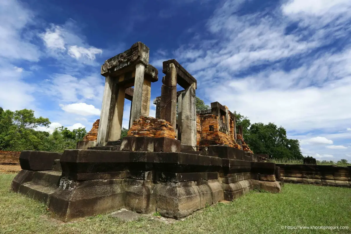
The innermost zone contains three sanctuaries on a shared platform, all facing north. The principal tower stands in the center and dominates the composition. Its inner chamber, or garbhagriha, once housed the main sacred image or linga. Two subsidiary sanctuaries flank it and may have contained associated deities or supported additional ritual functions. Their symmetrical placement focuses attention on the principal tower and creates an ordered cosmic composition.
A mandapa projects from the front of the main sanctuary. This chamber formed an intermediate space between the outer approach and the most sacred inner room. Offerings could be prepared or presented there, and priests or patrons may have assembled before entering the central chamber. Stairs approached the mandapa from the front and both sides. The alignment of successive doorways created a powerful visual axis leading toward the sanctuary’s center.
Elements surviving around the central sanctuary include sandstone doorframes, decorative door columns, window openings, stone balusters, wall foundations, and portions of the tower body. The balusters imitate forms originally developed in timber architecture, demonstrating how builders translated wooden designs into stone. Sandstone doorframes had to bear the weight of heavy lintels and upper masonry, requiring precise cutting, fitting, and weight distribution.
Two brick buildings stand on either side of the mandapa and face the principal sanctuary. Archaeologists interpret them as libraries or ritual halls. The conventional term “library” is used for a recurring building type in Khmer sanctuaries, although written manuscripts are rarely recovered from these structures. They may have held sacred objects, ritual equipment, offerings, or texts. Their inward orientation confirms a close relationship with the ceremonies of the central shrine.
A brick enclosure wall separated the innermost sanctuary from the surrounding precinct. Passing through the wall represented more than a physical movement; it marked entry into a more restricted sacred area. Along the eastern side stood an elongated rectangular brick building parallel to the enclosure. It had entrances on the western and northern sides, and portions of a decorated doorframe remain visible. Its original function may have involved ritual preparation, storage, or the administration of the sanctuary.
The inner gopura, or gateway, stands only on the northern side and contains three entrance passages. It is aligned with the mandapa and principal sanctuary. Multiple passages may have organized the movement of priests, attendants, patrons, and ritual objects. Sandstone frames and decorative columns strengthened the openings and gave the gateway a formal appearance appropriate to the threshold of the inner sacred enclosure.
Additional brick foundations survive beside the inner gateway near the front corners of the enclosure. A paved brick route connected one of these structures with the elongated eastern building. This evidence demonstrates that circulation inside the sanctuary was deliberately designed. Worshippers and attendants did not simply wander between buildings; routes helped establish a sequence from entry and preparation to the approach toward the principal deity.
The second zone consists of an outer boundary formed in association with a broad pond or moat. The water feature nearly surrounded the sanctuary but left an opening along the central northern approach. Earth removed during excavation of the pond was used to form an embankment around the inner complex. The project therefore combined water storage, drainage, boundary construction, and landscape design.
Water also carried religious meaning. In Hindu cosmology, the sacred mountain at the center of the universe is surrounded by cosmic oceans and continents. A moat around a sanctuary could evoke this ordered universe and separate divine space from the ordinary landscape. Practical engineering and religious symbolism were therefore not mutually exclusive; the same water system could manage seasonal conditions while reinforcing the temple’s cosmic identity.
A passage on the northern side crossed the water boundary and led toward the inner enclosure. The outer gateway was a large cruciform structure positioned directly in line with the inner gateway. Its projecting arms created the cross-shaped plan, while windows, stone balusters, and sandstone doorframes articulated the walls. The building marked the formal entrance to the entire sanctuary and controlled movement from the surrounding settlement into the ceremonial precinct.
The third architectural zone lies beyond the outer gateway on the northern side. Two buildings stand opposite each other, one facing east and the other west. Their bases incorporate laterite, sandstone, and brick, while their upper portions may have been built partly of timber. Both structures had high square platforms, projecting entrance sections, stairs on all four sides, individual enclosure walls, and gateways.
A sandstone linga-and-yoni base remained in the main room of the western building, while the eastern building contained another sandstone image pedestal. These remains demonstrate that sacred activity extended beyond the central enclosure. The buildings may have been subsidiary shrines, spaces for specialized ceremonies, or institutions serving groups connected with the main sanctuary. Their inward-facing orientation created a defined space between them that may have functioned as an additional ritual court.
The use of laterite in these outer foundations probably contributed to later descriptions identifying the entire monument as a laterite sanctuary. In reality, the archaeological plan shows a more sophisticated selection of materials. Brick and sandstone dominate the central sacred architecture, while laterite appears where a strong foundation was advantageous. Recognizing this variation provides a clearer understanding of ancient building knowledge.
The three-zone organization created a carefully controlled ceremonial journey. A visitor approaching from the north would pass the outer buildings, enter the monumental outer gopura, cross the water boundary, proceed through the inner gateway and enclosure wall, and finally reach the mandapa and central shrine. Each threshold reduced ordinary access and increased sacred intensity. Architecture organized society as well as space, because permission to enter particular zones likely depended on ritual role and social status.
Three sandstone inscriptions were discovered near the outer gopura. All were written in ancient Khmer script and the Khmer language and share compatible letter forms and subject matter. They are collectively known as the Prasat Mueang Khaek inscriptions and individually identified as Inscriptions 1, 2, and 3. Their survival gives the monument an exceptional historical dimension because they identify sacred images, royal commands, personnel, donations, and responsibilities associated with the functioning temple.
Inscription 1 records a royal command concerning the installation of several divine images and the incorporation of another deity associated with Lingapura. Officials and members of the court were ordered to maintain the images and sanctuary. People, rice, oil, and other resources were allocated for continuing service. The text reveals that a temple required a stable institutional economy rather than occasional ceremonial attention.
Inscription 2 consists largely of names of personnel assigned to the institution. Inscription 3 also lists people and concludes with offerings or property. Those attached to the temple may have cultivated land, prepared food, supplied oil and incense, maintained buildings, cared for sacred objects, performed craftwork, or assisted priests. The sanctuary was therefore an economic and social organization supported by a significant labor force.
Donations of land, agricultural produce, objects, and personnel were central to temple patronage in the ancient Khmer world. They provided dependable income and allowed daily offerings and annual ceremonies to continue. In return, the institution linked royal authority with divine protection and communicated the legitimacy of political power. Prasat Mueang Khaek was consequently a religious sanctuary, an administrative center, an economic institution, and a visible statement of authority.
The elaborate divine names recorded in the inscription combine honorifics, personal associations, and sacred titles. Installing an image was not merely a matter of placing sculpture inside a room. Ritual consecration established the image as a living divine presence, assigned property and personnel, and defined the rules by which worship would continue. Recording these arrangements in stone allowed future caretakers to preserve institutional memory.
The location of the inscriptions near the outer gateway was appropriate because the gateway connected the institution with the public landscape. Regulations and royal gifts could be acknowledged at a place through which attendants and visitors passed. The inscriptions are now preserved at Maha Viravong National Museum in Nakhon Ratchasima, where they are protected from weathering and can be examined by specialists.
Other excavated objects include lingas, linga pedestals, the Nandi bull, a pediment depicting Shiva and Uma, a lintel of Indra riding Airavata, the Vishnu reclining lintel, divine figures above kala motifs, and numerous sandstone architectural fragments. Moving vulnerable objects into museums protects them from theft, rain, temperature change, and biological deterioration. Visitors seeking a complete understanding should combine the archaeological site with relevant museum collections.
Kala is represented as a powerful face with wide eyes and an open mouth, often without a lower jaw. Vegetal forms may emerge from its mouth or sides. The motif symbolizes consuming time and protects the sacred doorway. When a divine figure appears above kala, the design emphasizes the deity’s position beyond ordinary time and destructive power. Variations in kala and surrounding foliage also help scholars date Khmer sculpture.
The Uma-Mahesvara scene presents Shiva together with Uma and expresses the union of masculine and feminine energy. It can symbolize fertility, harmony, legitimate rule, and cosmic stability. Indra riding Airavata represents the guardian of the eastern direction and a deity associated with rain, storms, and royal power. Each carved scene contributed to a structured network of meaning within the temple.
Prasat Non Ku lies approximately 500 meters south of Mueang Khaek along the principal axis. The two sanctuaries belong to a broadly similar period and share Hindu associations, but their size and layout differ. Mueang Khaek is larger and contains multiple layers of architecture, while Non Ku focuses on a single sanctuary raised on a high platform with subsidiary buildings. Their proximity suggests different ritual functions, patron groups, or institutional status within the same ancient community.
Sema Ancient Town lies nearby and preserves a moated urban settlement with a strong Dvaravati Buddhist foundation. Its religious monuments, sema stones, inscriptions, and sandstone sculptures provide a different cultural perspective. Studying Sema together with the Khorat Subdistrict temples reveals how the Sung Noen region changed from Dvaravati Buddhist urbanism toward increasing Hindu and Khmer political influence.
Prasat Mueang Kao represents a still later phase. It was the religious chapel of an Arogayasala, one of the ancient hospitals established during the reign of King Jayavarman VII. Its Mahayana Buddhist function contrasts with the Shaiva identity of Mueang Khaek. The monuments demonstrate that Sung Noen remained important from the 10th-century Hindu period into the late 12th and early 13th centuries.
Prasat Mueang Khaek was formally registered as a national ancient monument on 27 September 1936. Its recognized boundaries were developed through subsequent declarations in 1952 and 1983. Legal protection applies not only to visible masonry but also to archaeological deposits beneath the ground. Digging, construction, removal of artifacts, and alteration of the landscape are therefore regulated.
Major archaeological work included excavation in 1959 and further investigation, architectural clearance, and landscaping in 1990–1991. These projects exposed the sanctuary foundations, enclosure system, gateways, water features, and outer buildings. The three inscriptions were studied and translated after their discovery in 1992, making it possible to connect the physical remains with named deities, royal commands, donations, and institutional personnel.
Archaeological excavation differs from simply rebuilding a ruin. Soil must be removed layer by layer, artifacts and architectural relationships recorded, and masonry studied before conservation decisions are made. Original blocks can be stabilized or repositioned when reliable evidence exists, but missing towers should not be reconstructed according to imagination. This approach preserves authenticity and leaves information available for future research.
The present landscape includes maintained lawns, mature trees, interpretive signs, a ticket point, and parking. These improvements make the plan easier to understand, but the site remains exposed to rain, sunlight, water accumulation, soil movement, and tree roots. The 10th Regional Office of Fine Arts continues to inspect and manage the area, including drainage planning and visitor-support improvements during the rainy season.
Large trees provide shade and contribute to the atmosphere, yet roots growing through ancient foundations can displace brick and sandstone. Vegetation management at an archaeological monument must therefore balance landscape quality with structural safety. Monitoring cracks, settlement, moisture, and root direction is an essential part of long-term conservation.
A formal ticket service began on 25 September 2024, initially charging 10 baht for Thai visitors and 50 baht for foreign visitors. The current rate published in May 2026 is 10 baht for Thai visitors and 80 baht for foreign visitors. The monument remains open daily from 07.30 to 17.30. Revenue supports the management of the heritage site and visitor services.
The most comfortable visiting times are early morning between 07.30 and 10.00 or late afternoon after approximately 15.30. Temperatures are lower, and angled light reveals the surfaces of brick and sandstone more clearly. Morning suits visitors seeking a quiet historical experience, while late-afternoon light produces warm tones and long shadows across foundations and doorframes.
The cool season from November to February is ideal for extended exploration. During the hot season, carry drinking water, a hat, an umbrella, and sun protection because most architectural areas are exposed. The rainy season produces vivid green lawns but can make earth, steps, and stone slippery. Follow temporary barriers and official instructions when water accumulates or conservation work is underway.
For photography, begin on the northern approach so that the outer gateway, inner gateway, mandapa, and principal sanctuary align within the frame. Side views reveal the three sanctuaries sharing one platform. Lower viewpoints emphasize the height of sandstone columns and platforms. Close-up photographs of doorframes, balusters, tool marks, brick joints, and weathered surfaces show craftsmanship that wide views may miss.
Visitors must never climb, sit, or stand on ancient masonry to obtain a photograph. Wear supportive footwear because the site includes grass, soil, gravel, steps, and uneven surfaces. Do not push, lean against, or hold sandstone doorframes and columns. Although they appear massive, they have endured centuries of weathering and structural stress.
No brick, stone, pottery fragment, or other object may be removed. An apparently ordinary fragment may provide essential information when studied in its original position. If an unusual object is discovered, leave it untouched and notify staff. The relationship between an artifact, soil layer, and nearby structure is often more valuable than the object alone.
Families can use the site as an outdoor classroom by comparing brick, sandstone, and laterite, identifying the three architectural zones, and distinguishing the principal sanctuary from subsidiary buildings. Children should remain under close supervision and must not run across foundations, climb steps in restricted areas, or approach the water features without an adult.
Older travelers and visitors with limited mobility can view much of the complex from maintained lawns and surrounding paths. However, raised platforms, ancient steps, and uneven surfaces are not accessible at every point. Assistance is recommended, particularly during wet weather. Wheelchair users can obtain broad views from level ground even when individual sanctuary platforms cannot be entered.
Prasat Mueang Khaek provides the setting for Kin Khao Kham, a major cultural festival of Sung Noen. In the local Khorat dialect, the expression means eating the evening meal. The event combines shared local meals, historical presentations, light-and-sound performances, cultural shows, exhibitions, and community products. The ancient sanctuary becomes a setting through which local residents connect their contemporary identity with regional heritage.
The festival is a modern community tradition rather than a direct continuation of ancient Khmer worship. Its significance lies in encouraging local participation and transmitting knowledge to younger generations. Dates vary each year; in 2026 the festival was held from 13 to 15 March. Travelers planning future visits should check the annual announcement.
Festival periods bring temporary stages, lighting, vendors, and larger crowds. Parking and vehicle routes may differ from ordinary days. Visitors seeking quiet archaeological study should arrive in the morning, while those attending evening performances should allow additional travel time and follow the designated movement zones. Event equipment must be installed without placing damaging loads on ancient foundations.
A rewarding heritage route begins at Prasat Mueang Khaek, continues to nearby Prasat Non Ku, and then proceeds to Prasat Mueang Kao, Sema Ancient Town, and Wat Dhammachak Semaram. This sequence introduces early Khmer Hindu architecture, Dvaravati Buddhist urban traditions, and the later Mahayana hospital network. A full day is recommended for detailed exploration.
Prasat Non Ku is smaller than Mueang Khaek but retains a high platform and sandstone doorway components. Visiting both monuments makes differences in patronage, building scale, and spatial planning immediately visible. Sema Ancient Town, with its moats, ramparts, and dispersed Dvaravati monuments, shows that Sung Noen was a multi-centered cultural landscape rather than a single isolated temple settlement.
Wat Dhammachak Semaram houses a monumental Dvaravati sandstone Reclining Buddha. Traveling from Mueang Khaek to the temple shifts the visitor from the divine world of Hindu Khmer sculpture to the Buddhist environment of Dvaravati art. The contrast in sacred images, building forms, materials, and ritual traditions makes the combined route particularly valuable.
The Sung Noen Black Bridge represents a later stage of local transport history. Including the railway bridge in the itinerary connects ancient river and overland networks with the modern rail system that transformed Sung Noen. The district’s history can therefore be understood as an ongoing relationship between communities, movement, resources, and changing technologies.
Getting There from central Nakhon Ratchasima, follow Highway 2, or Mittraphap Road, toward Sung Noen and Saraburi. Near kilometer markers 221–222, turn onto Highway 2161 toward Sung Noen town. Continue for approximately 2.7–3 kilometers to the intersection near Wat Yanasophit Wanaram, also known locally as Wat Pa Sung Noen. Turn right, continue for about 1.5 kilometers, turn left, cross the railway line, and proceed approximately 1.6 kilometers. At the next junction, turn left; Prasat Mueang Khaek will be on the right.
From Bangkok, follow Phahonyothin Road to Saraburi and continue along Mittraphap Road through Muak Lek, Pak Chong, and Sikhio. Approximately 14.5 kilometers east of the Sikhio interchange, turn onto Highway 2161 toward Sung Noen. Traffic can be heavy through Muak Lek, Pak Chong, and Mittraphap Road during holidays, so allow additional time and reduce speed on local community roads.
Rail travelers can disembark at Sung Noen Railway Station and hire a local taxi or motorcycle taxi. Travelers planning to include Prasat Non Ku, Sema Ancient Town, and Wat Dhammachak Semaram should agree on the full itinerary and return pickup in advance because the attractions are dispersed and no regular service continuously connects every monument.
Allow approximately 1–2 hours for Prasat Mueang Khaek when reading signs, photographing the architecture, and examining all three zones. A half-day is appropriate when adding Prasat Non Ku and Prasat Mueang Kao. A full day is preferable for a route including Sema Ancient Town, Wat Dhammachak Semaram, and the Black Bridge. Most restaurants and accommodations are located in Sung Noen town or near Mittraphap Road.
Prasat Mueang Khaek is more than a picturesque ruin. Its architecture records the organization of sacred space, its sculpture communicates Hindu cosmology, its inscriptions reveal royal patronage and institutional labor, and its water system demonstrates planned landscape management. Studied together, these elements restore the monument’s meaning as an active religious, economic, and political institution rather than an abandoned collection of bricks and stones.
Preservation depends upon cooperation among the Fine Arts Department, local authorities, surrounding communities, and visitors. Admission revenue alone cannot prevent damage if people climb structures, move fragments, leave rubbish, or ignore restricted zones. Respectful behavior is a direct form of conservation because every brick and sandstone block contains historical information that cannot be recreated once destroyed.
Prasat Mueang Khaek is therefore an essential destination for travelers seeking the historical foundations of Nakhon Ratchasima and the ancient Khmer presence on the Khorat Plateau. Its three sanctuaries on a shared platform, unusual north-facing orientation, three-layered ceremonial plan, Vishnu reclining lintel, ancient Khmer inscriptions, Shaiva sculptures, and living Kin Khao Kham festival create a site of exceptional archaeological, artistic, and community value. Although the upper towers have disappeared, the surviving foundations and stone frames continue to communicate the beliefs, labor, and organization of a society that flourished more than a thousand years ago.
| Name | Prasat Mueang Khaek |
| Location | Ban Kok Kok, Moo 7, Khorat Subdistrict, Sung Noen District, Nakhon Ratchasima Province 30170, Thailand |
| Coordinates | 14.913063, 101.833750 |
| Monument Type | Ancient Khmer Hindu sanctuary dedicated primarily to Shaivism |
| Period | Late 10th to early 11th Buddhist centuries in Thai chronology, associated with the Koh Ker–Pre Rup artistic transition |
| Construction Materials | Sandstone and brick are the principal materials; laterite occurs in foundations of selected outer buildings |
| Highlights | Three sanctuaries on one platform facing north, with a mandapa, libraries, inner and outer gateways, enclosure walls, ponds, embankments, and ancient Khmer inscriptions |
| Important Evidence | Lingas, yoni pedestals, Nandi, Uma-Mahesvara pediment, Vishnu reclining lintel, Indra riding Airavata lintel, and three Prasat Mueang Khaek inscriptions |
| Architectural Plan | A rectangular north-facing complex divided into three progressively sacred architectural zones |
| Main Areas / Zones | 1. Inner Zone: principal sanctuary, two subsidiary sanctuaries, mandapa, libraries, and inner enclosure 2. Outer Zone: pond or moat, earthen embankment, and cruciform outer gopura 3. Northern Exterior Zone: two buildings with laterite, sandstone, and brick foundations, including a linga-yoni pedestal and image base |
| Open Days | Daily |
| Opening Hours | 07.30 – 17.30 |
| Admission Fees | Thai visitors 10 baht; foreign visitors 80 baht |
| Current Status | Open to visitors, conserved and landscaped, with continuing site-management and drainage monitoring |
| Caretaker | Fine Arts Department through the 10th Regional Office of Fine Arts, Nakhon Ratchasima, in cooperation with Khorat Subdistrict Administrative Organization |
| Main Contact Numbers | 044-471518, 044-481024 |
| Facilities | Ticket point, parking, interpretive signs, maintained lawns, and open-air visitor areas |
| Important Festival | Kin Khao Kham, the annual cultural and community festival of Sung Noen, held according to each year’s official schedule |
| Travel Information | Follow Mittraphap Road from Nakhon Ratchasima, turn onto Highway 2161 toward Sung Noen, turn near Wat Yanasophit Wanaram, cross the railway line, and continue toward Ban Kok Kok |
| Recommended Visit Duration | Approximately 1–2 hours, or half a day when combined with Prasat Non Ku and Prasat Mueang Kao |
| Nearby Tourist Attractions | 1. Prasat Non Ku, approximately 1 km 2. Prasat Mueang Kao, approximately 4 km 3. Sema Ancient Town, approximately 5 km 4. Sung Noen Black Bridge, approximately 6 km 5. Wat Dhammachak Semaram and the Sandstone Reclining Buddha, approximately 7 km |
| Nearby Restaurants | 1. Combo5 Café, approximately 8 km, Tel. 094-287-9876 2. Jae Tu Lab Ped, approximately 8 km, Tel. 089-719-1690 3. LanLao, approximately 8 km, Tel. 080-004-0925 4. Chan Mit Han Phalo, approximately 9 km, Tel. 044-419-595 5. Ran Lab Ban Lao, approximately 10 km, Tel. 044-286-892 |
| Nearby Accommodations | 1. High Hill Fresh Resort, approximately 4 km, Tel. 098-556-4664 2. The Lofts Eco Resort, approximately 7 km, Tel. 081-987-1518 3. Phloi Namkhang Resort, approximately 8 km, Tel. 086-500-8099 4. Sema Nakhon Hotel, approximately 8 km, Tel. 086-262-7985 5. Baan Sakulpetch Hotel, approximately 10 km, Tel. 088-079-4650 |
Frequently Asked Questions (FAQ)
Q: Where is Prasat Mueang Khaek located?
A: It is located at Ban Kok Kok, Moo 7, Khorat Subdistrict, Sung Noen District, Nakhon Ratchasima Province, close to Prasat Non Ku and the Old Khorat Town archaeological landscape.
Q: What days and hours is Prasat Mueang Khaek open?
A: The monument is open daily from 07.30 to 17.30.
Q: How much is the admission fee?
A: The current admission fee is 10 baht for Thai visitors and 80 baht for foreign visitors.
Q: Was Prasat Mueang Khaek built entirely of laterite?
A: No. Sandstone and brick are the principal construction materials. Laterite was used in foundations of some buildings in the outer northern zone.
Q: Which religion was Prasat Mueang Khaek associated with?
A: It was a Hindu sanctuary dedicated primarily to Shaivism. Lingas, yoni pedestals, and a Nandi sculpture provide important evidence of Shiva worship.
Q: What is distinctive about the architectural plan?
A: Three sanctuaries stand on a shared platform facing north. The complex is divided into three zones and includes a mandapa, libraries, gateways, enclosure walls, water features, embankments, and exterior shrines.
Q: How long should travelers spend at the monument?
A: Allow approximately 1–2 hours. A half-day or full day is recommended when combining the visit with Prasat Non Ku, Prasat Mueang Kao, Sema Ancient Town, and Wat Dhammachak Semaram.
Q: Can travelers reach the site by train?
A: Yes. Disembark at Sung Noen Railway Station and continue by local taxi or motorcycle taxi. Arrange transport in advance when visiting several archaeological sites.
 Category: ●Art, Culture and Heritage
 Group: ●Historical Sites and Monuments
Last Update : 3 MonthAgo
 Last Update : 3 MonthAgo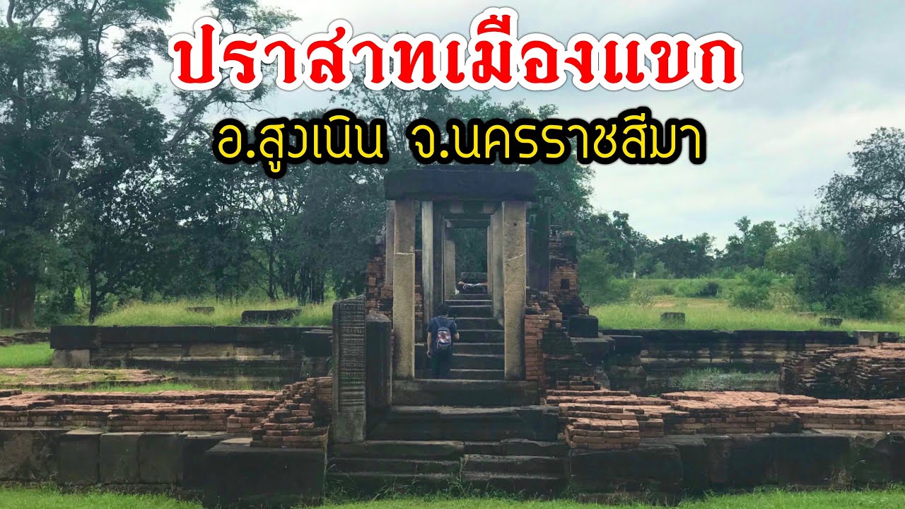
 Click to Access the Navigation Map GPS
Prasat Muang Khaek Map
Recommend
 Historical Sites and Monuments(20)
 Landmarks and Memorials(5)
 Art, Craft Centres, Tradition(7)
 Museums(6)
 Art Gallery(1)
 Educational Places
 Educational Gardens, Farm(4)
 Places of Worship
 Temple(29)
 Mosque(1)
 Other Sacred Sites(6)
 Research and Development
 Royal Project(3)
 Suburban Living
 Village, Community(6)
 Local Market(4)
 Floating Market(1)
 Nature and Wildlife
 National Parks and Marine Reserves(3)
 Mountain (Doi)(5)
 Dam, Reservoir, Lake(8)
 Waterfalls(9)
 Hot Springs(1)
 Caves(2)
 Flower Field(1)
 River, Canal(8)
 Bays and Beaches(2)
 Other natural attractions(3)
 Entertainment and Agricultural
 Zoos and Aquariums(2)
 Animal camps and shows(1)
 Farms, Parks and Ecotourism(21)
 Waterpark(4)
 Outdoor and Adventure Activities(6)
 Shopping
 Shopping and Night Market(2)
 Travel Articles, Recipes
 Travel Review, Food Review(6)


