
lovethailand home >Northeastern Travel Attractions >Nakhon Ratchasima Travel Attractions >Huai Thalaeng >Lung Pradu > Prasat Ku Sila
TL;DR: Prasat Ku Sila is located at Inside Wat Ku Sila Khan, Ban Ku Sila Khan, Moo 4, Lung Pradu Subdistrict, Huai Thalaeng District, Nakhon Ratchasima Province, open Daily, hours 08:00 – 17:00 is the recommended period for visiting the temple grounds and.
Prasat Ku Sila
Open Days: Daily
Opening Hours: 08:00 – 17:00 is the recommended period for visiting the temple grounds and archaeological site
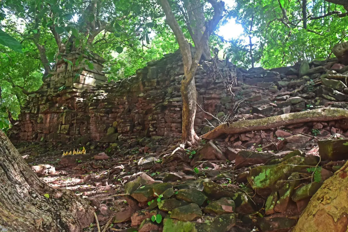
Prasat Ku Sila, also known as Ku Sila Khan, is an ancient Khmer archaeological monument associated with the royal-road network between Angkor and Phimai. It stands inside Wat Ku Sila Khan in Ban Ku Sila Khan, Moo 4, Lung Pradu Subdistrict, Huai Thalaeng District, Nakhon Ratchasima Province. The monument occupies a large earthen mound and survives as the heavily collapsed remains of a sandstone building. Its roof has fallen into the center, weathered sandstone blocks are scattered around the mound, and large trees grow over and through the ancient structure. A limited section of masonry and architectural fragments still provide evidence of a dharmasala or Vahni-griha constructed during the reign of King Jayavarman VII. Admission is free, but visitors must not climb, touch, or move the stones. Daytime visits between 08:00 and 17:00 are recommended because the site has uneven ground, limited lighting, and no permanent visitor staff.
The monument is recorded under several closely related names, including Prasat Ku Sila, Prasat Ku Sila Khan, Prang Ku Sila, and Ku Sila Khan. All refer to the same archaeological site. The word ku is widely used in northeastern Thailand for a small ancient sanctuary, sacred tower, stupa, or ruined religious structure. Sila means stone, reflecting the principal construction material of the monument. Khan survives in the names of the village, temple, and archaeological site. Ku Sila Khan is therefore more than the name of an isolated ruin; it is part of the local identity preserved through place-names, annual ceremonies, and community memory.
Prasat Ku Sila lies approximately 12 km north of central Huai Thalaeng. The surrounding landscape consists of agricultural land, rural communities, an active Buddhist temple, and mature trees. This setting helps explain that the monument was not constructed in an empty or isolated location. A stopping place on a long-distance route required access to water, food, nearby settlements, and terrain that travelers could approach safely. The position of Ku Sila Khan therefore preserves geographical evidence of the road leading between Phimai and important religious and administrative centers farther south.
The principal historical importance of Ku Sila Khan is its identification as a dharmasala or Vahni-griha. Vahni-griha is a Sanskrit term commonly translated as a “house with fire.” Archaeologists use it for small religious buildings associated with traveler-resting stations established along major roads of the ancient Khmer Empire. The surviving stone building should not be imagined as a dormitory in which large groups slept inside a narrow chamber. It was more probably the sacred center of a stopping complex, while shelters, kitchens, animal areas, and other service buildings may have been constructed from timber and perishable materials that have disappeared.
The inscription of Preah Khan at Angkor records the establishment of 121 Vahni-griha buildings along important routes during the reign of King Jayavarman VII. This network demonstrates that long-distance movement depended on more than roads. Resting places, shrines, water supplies, and supporting communities helped travelers move through the empire. Seventeen dharmasalas have been identified along the route between Angkor and Phimai. Eight stand in present-day Cambodia, while 9 are located in Thailand. Repeating a recognizable architectural form along the route created order, support, and visible royal authority across territories far from the capital.
The 9 dharmasalas in Thailand begin with Prasat Ta Muean in Surin Province. The route then continues through the monuments of Thamo, Ban Bu, Nong Kong, Nong Plong, Nong Ta Pleng, and Ban Samrong in Buriram Province before reaching Prasat Huai Khaen and Ku Sila Khan in Nakhon Ratchasima Province and finally Phimai. Ku Sila Khan is therefore the last of the Thai dharmasalas encountered when traveling north from Angkor toward Phimai. When the journey begins at Phimai and proceeds toward Angkor, it becomes the first dharmasala on the route. Descriptions calling it either the “first” or the “last” are both correct when the direction of travel is specified.
King Jayavarman VII ruled during the late 12th and early 13th centuries CE and was an important patron of Mahayana Buddhism. His public-building program included temples, roads, bridges, Arokayasala hospitals, and dharmasalas. These projects expressed an ideal of royal responsibility in which the ruler sought to relieve suffering and improve movement through the realm. A dharmasala therefore combined religious, political, and practical meanings. Travelers received access to a protected stopping place and sacred support, while the repeated architecture communicated the presence and authority of the state along distant roads.
Phimai was the northern destination of this royal-road system. The city developed in the Mun River basin around the monumental sanctuary now preserved within Phimai Historical Park. The route served more than royal officials and armies. Monks, pilgrims, traders, craftsmen, messengers, and ordinary travelers also moved between regional communities. Resting stations allowed them to plan overnight stops, obtain water, care for animals, perform protective rituals, and continue the journey in stages. Ku Sila Khan proves that the Huai Thalaeng area participated in a major regional transportation network approximately 800 years ago.
The standard Vahni-griha plan is a rectangular building facing east. It normally has doorways at the eastern and western ends, several windows in the southern wall, and a solid northern wall. Although the destruction of Ku Sila Khan prevents every architectural element from being read clearly, surviving masonry, doorway fragments, foundation stones, and scattered architectural pieces can be compared with better-preserved examples such as Prasat Ban Bu and Prasat Huai Khaen. Comparative study allows archaeologists to reconstruct the probable form and function of the ruined building without inventing unsupported details.
The eastern orientation relates to sunrise, light, renewal, and the ceremonial entrance to sacred space, all common themes in ancient Khmer architecture. The eastern door formed the main approach, while the western opening may have provided an exit or connection to supporting spaces. Windows in the southern wall brought light and ventilation into the interior, whereas the solid northern wall offered structural stability and protection from weather. The plan therefore balanced religious symbolism with practical environmental considerations.
Ku Sila Khan is exceptional among the 9 dharmasalas in Thailand because surveys describe its principal building as constructed entirely from sandstone. Most other examples used laterite for the main walls and reserved sandstone for doorframes, lintels, columns, and carved components. The extensive use of sandstone gave Ku Sila Khan a different color, surface, weight, and pattern of deterioration. Sandstone can be shaped accurately, but it is vulnerable to moisture, temperature variation, salt movement, biological growth, and pressure from tree roots. When maintenance ceases for a long period, the stone may split into layers or disintegrate into grains.
Many blocks at the site have deteriorated into fragments and have lost enough surface detail to make their original positions difficult to identify. This damage develops gradually. Rainwater enters pores in the stone and repeatedly evaporates. Heating during the day and cooling at night create cycles of expansion and contraction. Shade and retained moisture encourage moss, algae, and microorganisms. These processes interact with the weight of the building, settlement of the mound, and past disturbance until the walls and roof can no longer retain their original balance.
The large trees growing over the monument create both a dramatic appearance and a serious conservation problem. Roots enter joints between blocks and gradually force the stones apart. The canopy retains moisture and slows drying after rain. However, cutting down a mature tree without structural planning can also be dangerous because some roots may now help support unstable soil or masonry. Tree management at an archaeological monument must therefore be planned by conservators, archaeologists, structural specialists, and arborists. Visitors and local residents should never cut roots, excavate around trunks, or rearrange stones independently.
The roof has collapsed into the center of the building, leaving piles of sandstone across the mound. Some fragments appear to belong to clustered mouldings or the former upper tower. These pieces suggest that the original roof rose in diminishing levels above the main chamber. Even when a stone no longer stands in its original position, its measurements, shape, joints, and find location can help archaeologists reconstruct the sequence of collapse and prepare a hypothetical architectural drawing. Moving a fragment without recording it therefore destroys information.
The remaining wall provides valuable evidence of construction technique. Each block was shaped to relate to its location within the masonry. Ancient Khmer builders did not rely on modern cement mortar. Stability depended on the weight of the stone, accurately prepared surfaces, careful courses, and specially shaped joints in selected positions. When a foundation stone shifts, the upper wall loses alignment and may collapse. Examining the masonry helps visitors understand that building a dharmasala required quarrying knowledge, transportation, surveying, and control of structural loads rather than simply stacking stones.
Constructing most of the building from sandstone also demonstrates the ability to mobilize considerable resources. Builders needed a suitable quarry, workers to extract blocks, masons to finish the surfaces, transport systems, and labor capable of lifting heavy stones into position. Different specialists probably surveyed the plan, cut stone, assembled walls, carved architectural details, and performed foundation rituals. Although Ku Sila Khan was much smaller than Prasat Hin Phimai, its construction still required organized labor and a relationship between royal authority and surrounding communities.
A dharmasala should not be understood as a hotel in the modern sense. The surviving stone chamber is too small and too clearly religious to have accommodated every traveler. The actual sleeping shelters may have been timber halls or temporary structures nearby. Travelers could worship a sacred image, request protection, perform rituals, maintain a useful fire, and rest within the larger compound before continuing. The translation “house with fire” may refer to ritual fire, a protected flame, practical fire, or symbolic hospitality, but the surviving evidence does not prove that every building maintained a permanently burning fire at all times.
Mahayana Buddhist thought during the reign of Jayavarman VII emphasized the compassion of bodhisattvas who acted to relieve the suffering of living beings. Roads, hospitals, and traveler facilities can be understood as material expressions of this ideal. The dharmasalas also transmitted artistic forms, ritual practices, language, and political symbols from the center to distant communities. Ku Sila Khan therefore represents the meeting point of religion, mobility, and administration rather than merely a ruined example of Khmer art.
Dharmasalas were not placed at mathematically identical distances. Their locations responded to terrain, water, safety, and communities capable of supporting travelers. Some sections of the royal road crossed plains, forests, hills, or mountain passes. The distance between stations therefore reflected the difficulty of each stage. Ku Sila Khan stood before the final approach to Phimai for travelers arriving from the south. It may have functioned as a last stopping place before entry into a major regional city containing a monumental sanctuary, markets, administrators, and a large population.
Prasat Huai Khaen is another dharmasala in Huai Thalaeng District. It was built mainly from laterite and preserves a form that can be read more easily than the heavily collapsed Ku Sila Khan. Visiting both sites allows travelers to compare materials and deterioration. Laterite is porous and dark red, while the sandstone at Ku Sila Khan splits into layers and loose grains. The same architectural concept produced different visual results and conservation requirements when executed in different materials.
Prasat Ban Bu in Buriram Province is another useful comparison. It faces east, has 5 windows in the southern wall, a solid northern wall, and entrances at the eastern and western ends. This plan provides a model for interpreting Ku Sila Khan. Nevertheless, the details of Ban Bu must not simply be copied and treated as evidence for every missing feature at Ku Sila Khan. Each monument has a different history of construction, alteration, collapse, and material use. Archaeological excavation is required to establish the real wall lines, openings, and associated structures of the Nakhon Ratchasima site.
Ku Sila Khan was registered as a national ancient monument in the Royal Gazette, Volume 53, Part 34, dated 27 September 1936. Legal protection applies to the building, earthen mound, displaced stone blocks, artifacts, and archaeological deposits. Visitors may not remove sandstone, pottery fragments, soil, or any object from the area. Even a plain and very small fragment may help identify chronology, building technique, or past activity. Unauthorized digging or rearrangement can permanently destroy information that cannot be recreated.
From 13 to 17 May 2024, the Conservation of Ancient Monuments Group of the 10th Regional Office of Fine Arts conducted measured survey and drawing work in preparation for archaeological excavation at Ku Sila Khan. Such work is essential before excavation or stabilization. Specialists record levels, prepare plans, photograph individual blocks, examine cracks, and study the relationship between the structure and mound. The results help identify safe excavation areas, structural risks, tree-management requirements, and drainage problems. Surveying does not mean that the monument can immediately be rebuilt; it creates an evidence base for responsible future conservation.
Archaeological excavation is not a search for treasure. Its purpose is to reveal structures and soil layers systematically. Every deposit and artifact must be recorded by location, depth, and relationship to other evidence. When a fallen stone is found, archaeologists compare its joints and dimensions with gaps in the surviving architecture. Mechanical or hurried digging can destroy thin layers that record construction, occupation, abandonment, and collapse. Work may therefore proceed in several phases according to funding, safety, and conservation priorities.
Restoring Ku Sila Khan is particularly difficult because many sandstone blocks have lost their original strength. Reassembling weakened stones under heavy structural loads could cause further fracture. Conservators must distinguish between reusable blocks, fragments that should remain where discovered, and pieces requiring protected storage or display. The most appropriate conservation may focus on stabilizing surviving walls and preserving the archaeological layout rather than reconstructing a complete tower unsupported by sufficient evidence.
Drainage is another major concern. The large mound must shed rainwater without erosion or prolonged saturation beneath the building. Ponded water softens soil and causes uneven settlement. Roots and animal burrows create channels that carry moisture deeper into the mound. Drainage improvements must preserve ancient levels and avoid cutting through archaeological deposits. Grass control, visitor paths, and management of bare soil all affect water movement and therefore the long-term survival of the sandstone.
The monument stands inside an active Theravada Buddhist temple. The same area therefore contains heritage from 2 very different periods: a Mahayana Buddhist road shrine of the ancient Khmer world and a modern Thai monastic community. Continuous use has helped prevent complete abandonment, but management must accommodate worship, ceremonies, traffic, and modern temple buildings. The temple and village maintain cleanliness, observe unusual activity, and provide information to visitors, while structural conservation remains under the legal authority of the Fine Arts Department.
Publicly available information identifies Phra Athikan Kawi Phuriyano as the abbot of Wat Ku Sila Khan. The abbot, temple committee, and community oversee monastic activities and everyday use of the grounds. However, any removal of stone, excavation, tree work affecting the monument, or construction near the protected area requires coordination with the Fine Arts Department. Academic groups, large tours, and commercial filming teams should contact the temple, Lung Pradu Subdistrict Administrative Organization, or the 10th Regional Office of Fine Arts before visiting.
The community continues to hold a worship ceremony for Prang Ku Sila on the full moon of the 5th lunar month, usually falling around April. The exact solar-calendar date changes each year. The ceremony shows that local residents continue to recognize the monument as a sacred place even though the original meaning of the Jayavarman VII-period dharmasala has changed. Local accounts also mention ritual bathing and rocket-related activities during the annual season. Such traditions make Ku Sila a living cultural heritage site rather than an archaeological ruin disconnected from present society.
Contemporary ritual must be compatible with conservation. Incense, candles, fire, wax, and oil should not be placed against ancient sandstone because heat and residue stain and weaken the surface. Offerings should be placed only at designated worship points. Large groups should avoid standing on stone piles or moving fragments to create activity space. Local faith and archaeological protection can support one another when ceremonies respect both community belief and the physical needs of the monument.
Visitors should begin at the outer edge of the mound and observe the overall landform, mature trees, and position of the ruin before approaching along the designated path. This wider view makes it clear that the building stands on a substantial mound rather than ordinary level ground. From closer positions, visitors can examine the surviving wall, collapsed roof area, doorway fragments, and clustered tower mouldings. Barriers and warning signs must be respected because stones that appear stable may rest upon fractured blocks or loose soil.
The site can be interpreted through several zones: the temple courtyard and approach, the archaeological mound, surviving sandstone masonry, the central roof-collapse area, piles of architectural fragments, remains of upper-tower mouldings, the mature-tree and root zone, and areas used for survey or excavation. These zones may not be separated by fences, but recognizing them encourages a careful walking sequence. Visitors must not climb the stone pile for photographs, both because of injury risk and because movement changes the archaeological position of fragments.
Photography should emphasize the relationship between the ruin, trees, mound, and living temple. Close views can record weathered surfaces and masonry joints, but a zoom lens or change of standing position should replace physical contact. Morning provides softer light and lower temperatures. Late afternoon creates stronger shadows around roots and surviving walls. Fallen leaves can conceal stones and holes, so photographers concentrating on the viewfinder should move carefully.
November to February generally provides the most comfortable conditions. March to May can be hot even beneath the trees, making morning visits preferable. During the rainy season the vegetation becomes greener, but the mound can be slippery, water may flow between the stones, and branches can fall during storms. Travelers should check the weather, wear footwear with reliable grip, and avoid unstable walls in heavy rain or strong wind.
Facilities are those of a local temple rather than a large tourist center. Parking, a resting pavilion, temple restrooms, and a path to the mound are available, but there is no ticket office, permanent exhibition, souvenir shop, or full-time guide. Bring drinking water, mosquito repellent, sun protection, and suitable shoes. Older visitors can view the site from the courtyard and lower mound, while wheelchair users should travel with assistance and assess the path before approaching the ruin.
Admission is free. Donations may be made to the temple at designated points, but they are not entrance fees and should never be left on ancient stones. Groups should notify the temple in advance, especially when arriving by bus or planning educational activities. Daytime access between 08:00 and 17:00 is recommended. Night visits are unsuitable because lighting is limited, the ground is uneven, and no visitor staff remain permanently at the monument.
Visitor etiquette must respect both an active monastery and a protected archaeological site. Wear modest clothing, keep noise low, do not smoke or consume alcohol, remove rubbish, and do not fly a drone without permission. Climbing walls, sitting on stones, moving fragments, and collecting sandstone are prohibited. Parents should supervise children because roots, slopes, and spaces between fallen blocks create tripping hazards.
Ku Sila Khan is valuable for educational visits. Students can study the difference between a temple tower, a dharmasala, and a traveler-resting complex; examine the royal-road network; and learn about sandstone deterioration and archaeological conservation. Drawing a plan from visible evidence, comparing it with a standard Vahni-griha plan, or documenting tree-root impacts encourages observation without touching artifacts. The incomplete state of the monument does not reduce its educational value. It demonstrates directly how time, vegetation, water, and human activity alter cultural heritage.
University students in archaeology, architecture, and conservation can study several complex issues at the site: reconstructing plans from limited remains, managing trees on monuments, stabilizing weakened sandstone, controlling visitor routes, and balancing a modern temple with protected ruins. Comparing historical photographs with current conditions can measure changes in vegetation and masonry. Ku Sila Khan therefore teaches conservation processes as effectively as it teaches ancient Khmer architectural history.
For general travelers, the attraction lies in the quiet atmosphere and the opportunity to encounter a site not yet transformed into a heavily commercial tourist destination. There are no rows of shops, theatrical reconstructions, or newly built replicas. Visitors see the genuine results of collapse, weathering, tree growth, and long-term community use. The monument may be less visually monumental than Phimai, but it provides a powerful lesson in the vulnerability of archaeological evidence.
Getting There from central Huai Thalaeng requires following local roads toward Lung Pradu Subdistrict and Ban Ku Sila Khan for approximately 12 km. Enter Wat Ku Sila Khan, where the archaeological mound stands within the temple grounds. The coordinates are approximately 15.077366, 102.606219. The final road passes through villages and agricultural areas, so drivers should reduce speed and watch for motorcycles, farm vehicles, and animals. Navigation should be set specifically to Wat Ku Sila Khan in Huai Thalaeng District because similar temple and monument names occur elsewhere.
From Phimai, use the regional road network toward Huai Thalaeng and Lung Pradu. The driving distance is approximately 25 km and normally requires 35–45 minutes. This route suits travelers following the first dharmasala outward from Phimai. Begin at Phimai Historical Park or Prasat Kuti Rishi, continue to Ku Sila Khan, and then visit Prasat Huai Khaen to compare a sandstone dharmasala with a laterite example.
From Nakhon Ratchasima city, follow Highway 226 through Chakkarat to Huai Thalaeng, then take local roads toward Lung Pradu and Ban Ku Sila Khan. The total distance is approximately 85–95 km depending on the starting point and selected route, requiring around 1.5–2 hours. A private or rental vehicle is the most convenient option because no scheduled public transport stops directly at the temple. Fuel should be purchased in Huai Thalaeng or along Highway 226.
Rail travelers can disembark at Huai Thalaeng Railway Station on the Northeastern Line and hire a local vehicle for the remaining 12 km. Agree on the fare, waiting time, and return journey before leaving the station because no regular taxi service waits at the temple. Bus passengers can use the same method from central Huai Thalaeng. Train and bus schedules should be checked directly with the operators, particularly for evening return services.
A half-day route can begin with breakfast in Huai Thalaeng, followed by Ku Sila Khan for 45–90 minutes and Prasat Huai Khaen before returning to town for lunch. A full-day plan can continue to Prasat Kuti Rishi, Phimai Historical Park, Phimai National Museum, and Sai Ngam. This sequence presents a traveler shrine, an Arokayasala hospital chapel, the regional sacred center at Phimai, museum interpretation, and the Mun River landscape within one day.
Travelers seeking a complete royal-road experience can plan a multi-day journey from Phimai through Ku Sila Khan, Prasat Huai Khaen, Ban Samrong, Nong Ta Pleng, Nong Plong, Nong Kong, Ban Bu, Thamo, and the Ta Muean group. A private vehicle and careful planning are essential because many sites stand inside villages, temples, schools, or agricultural land. Access conditions vary. Visiting the entire sequence reveals the scale of Jayavarman VII’s public-infrastructure program more clearly than any single monument can.
Most restaurants are located in central Huai Thalaeng, around 12–13 km from Ku Sila Khan. Pa Khiat Grilled Chicken stands behind the railway station and is known for Huai Thalaeng-style grilled chicken. Tung Na Coffee @ Huai Thalaeng offers noodles, meals, drinks, and bakery items in a rural-themed setting. Jungle Cafe provides drinks and snacks, while Phon Nuea Yang 39 serves grilled dishes and jaew hon in the evening. Sit_Nee is another local dining and social venue. Groups should call before arrival because business hours may change.
Huai Thalaeng grilled chicken is the local food most closely associated with the district. The chicken is marinated and grilled until aromatic, then served with sticky rice, som tam, and dipping sauce. Other common choices include northeastern Thai food, larb, nam tok, jaew hon, noodles, and made-to-order dishes. Supporting local restaurants connects an archaeological journey with the district’s food culture. Meals should not be taken onto the mound because food waste attracts animals and increases rubbish around the temple.
Accommodation is concentrated in central Huai Thalaeng and along Highway 226. Sleep Tight Hotel provides rooms and parking in town. Sooksan Resort offers a garden-style setting in Thap Sawai Subdistrict. Pechra Naka Resort is a smaller local property, while Suan Manao Resort provides daily rooms within the community. Advance booking is recommended during festivals, long weekends, and group travel. Confirm the map location directly with the property because some resort names can appear at more than one location online.
Allow approximately 45–90 minutes for a meaningful visit. A quick stop may take 30 minutes, but travelers interested in history should observe the mound, materials, masonry, roots, and orientation. Slow observation reveals details that photographs often miss, including granular stone decay, accumulated soil, and the changing level of the collapsed structure. The goal is not to climb for a dramatic viewpoint but to preserve the evidence in its existing position.
The value of Ku Sila Khan does not depend on a complete tower or spectacular reliefs. Its significance lies in the dharmasala network, its unusual sandstone construction, its position before Phimai, and the conservation problems visible across the ruin. The collapse allows specialists to study stone decay, root action, foundation settlement, and the consequences of continuing land use. These processes are often less visible at monuments that have already been extensively reconstructed.
For the community, Ku Sila Khan unites the names of the village and temple with annual ritual and local pride. The full-moon ceremony introduces younger residents to the monument and creates opportunities for elders to pass on local knowledge. Community observation is critical because conservation officers cannot remain permanently at every site. Tourism development should remain proportionate, avoid construction on the mound, and prevent events that create heavy vibration, fire, or excessive waste.
Travelers can support conservation by following signs, avoiding contact with fragile stones, using local restaurants and accommodation, and sharing accurate information. Photographs should identify the location clearly as Prasat Ku Sila or Ku Sila Khan in Huai Thalaeng District, Nakhon Ratchasima Province. Any unauthorized digging, stone movement, or new damage should be reported to the temple, Lung Pradu Subdistrict Administrative Organization, or the 10th Regional Office of Fine Arts rather than corrected independently.
Prasat Ku Sila is an appropriate destination for travelers who wish to understand history beyond monumental and fully restored temples. Standing among weathered sandstone beneath mature trees reveals both the achievement of builders 800 years ago and the vulnerability of stone exposed to time, nature, and human activity. The site has changed from a royal-road dharmasala into an archaeological monument inside a living temple and a center of community ceremony. Its story has therefore continued through several cultural periods.
A visit should be approached with the understanding that authenticity, not architectural completeness, is the principal attraction. Only limited wall lines survive; the roof has collapsed, stone is fragmented, and trees dominate the mound. Yet these remains preserve evidence of the Angkor–Phimai road, Mahayana Buddhist public works, sandstone technology, and the movement of travelers under Jayavarman VII. When combined with Prasat Huai Khaen, Prasat Kuti Rishi, and Phimai Historical Park, Ku Sila Khan becomes an essential key to understanding the historical landscape of Nakhon Ratchasima and northeastern Thailand.
| Name | Prasat Ku Sila, also known as Ku Sila Khan |
| Alternative Names | Prasat Ku Sila Khan, Prang Ku Sila, Ku Sila Khan |
| Location | Inside Wat Ku Sila Khan, Ban Ku Sila Khan, Moo 4, Lung Pradu Subdistrict, Huai Thalaeng District, Nakhon Ratchasima Province |
| Address | Moo 4, Ban Ku Sila Khan, Lung Pradu, Huai Thalaeng, Nakhon Ratchasima 30240, Thailand |
| Coordinates | 15.077366, 102.606219 |
| Site Type | Dharmasala or Vahni-griha, a religious building associated with a traveler-resting station on the ancient royal road |
| Period | Reign of King Jayavarman VII, approximately the late 12th to early 13th century CE |
| Religion And Belief | Mahayana Buddhism and the concept of religious facilities serving travelers |
| Position On The Route | The first dharmasala after leaving Phimai toward Angkor and the last before reaching Phimai when traveling from Angkor |
| Dharmasala Network | 1 of 17 known dharmasalas on the Angkor–Phimai route and 1 of 9 located in present-day Thailand |
| Main Material | Sandstone; its principal building is identified as the only Thai-route dharmasala constructed entirely from sandstone |
| Highlights | A heavily collapsed sandstone structure on a large mound, with surviving masonry, a central roof collapse, scattered blocks, and fragments of upper-tower mouldings |
| Architectural Form | Rectangular Vahni-griha form, normally with an eastern main entrance, southern windows, and a solid northern wall |
| Main Areas And Zones | 1. Temple courtyard and approach 2. Large archaeological mound 3. Surviving sandstone wall 4. Central roof-collapse area 5. Scattered sandstone and architectural fragments 6. Clustered mouldings and upper-tower fragments 7. Mature-tree and root zone 8. Archaeological survey and excavation area |
| Conservation Condition | Severely damaged, with mature trees and deteriorated sandstone; the Fine Arts Department conducted measured survey work for planned excavation in May 2024 |
| National Registration | Registered as a national ancient monument in the Royal Gazette, Volume 53, Part 34, dated 27 September 1936 |
| Local Tradition | Annual worship ceremony on the full moon of the 5th lunar month, together with temple and community merit-making activities |
| Open Days | Daily |
| Opening Hours | 08:00 – 17:00 is the recommended daytime visiting period |
| Admission Fee | Free admission; voluntary temple donations may be made at designated points |
| Recommended Visit Duration | Approximately 45–90 minutes |
| Facilities | Temple parking, resting pavilion, temple restrooms, and a path to the mound; no permanent visitor center or guide |
| Archaeological Caretaker | Fine Arts Department through the 10th Regional Office of Fine Arts, in cooperation with Wat Ku Sila Khan, Lung Pradu Subdistrict Administrative Organization, and the community |
| Abbot | Phra Athikan Kawi Phuriyano |
| Official Contact Numbers | 10th Regional Office of Fine Arts, Nakhon Ratchasima: +66 44 471 518 Lung Pradu Subdistrict Administrative Organization: +66 44 950 623 |
| Travel Information | Approximately 12 km from central Huai Thalaeng via Lung Pradu Subdistrict and about 25 km by road from Phimai |
| Visitor Rules | Do not climb or move stones, excavate soil, or remove fragments. Watch for roots, slopes, loose blocks, and unstable masonry. |
| Current Status | Open within the temple grounds as a protected national monument undergoing archaeological study and conservation planning |
| Nearby Tourist Attractions | 1. Prasat Huai Khaen, approximately 18 km; 10th Regional Office of Fine Arts Tel. +66 44 471 518 2. Prasat Kuti Rishi Or Phimai Arokayasala, approximately 23 km 3. Phimai Historical Park, approximately 25 km, Tel. +66 44 471 568 4. Phimai National Museum, approximately 26 km, Tel. +66 44 471 167 5. Sai Ngam Banyan Grove, approximately 28 km; Phimai Municipality Tel. +66 44 002 323 |
| Nearby Restaurants | 1. Pa Khiat Grilled Chicken Huai Thalaeng, approximately 12 km, Tel. +66 85 015 8553 2. Tung Na Coffee @ Huai Thalaeng, approximately 12 km, Tel. +66 80 351 4938 3. Jungle Cafe Huai Thalaeng, approximately 12 km, Tel. +66 86 023 0263 4. Phon Nuea Yang 39, approximately 13 km, Tel. +66 92 631 8893 5. Sit_Nee Huai Thalaeng, approximately 13 km, Tel. +66 81 158 4719, +66 81 905 0898 |
| Nearby Accommodations | 1. Sleep Tight Hotel Huai Thalaeng, approximately 12 km, Tel. +66 98 881 0108, +66 44 001 665 2. Sooksan Resort Huai Thalaeng, approximately 13 km, Tel. +66 98 631 9795 3. Pechra Naka Resort Huai Thalaeng, approximately 14 km, Tel. +66 62 135 4358, +66 88 968 7898 4. Suan Manao Resort Huai Thalaeng, approximately 16 km, Tel. +66 63 979 1414 5. Hotels And Guesthouses In Central Phimai, approximately 25 km; Phimai Historical Park Tourist Information Tel. +66 44 471 568 |
Frequently Asked Questions (FAQ)
Q: Where is Prasat Ku Sila located?
A: It is located inside Wat Ku Sila Khan in Ban Ku Sila Khan, Moo 4, Lung Pradu Subdistrict, Huai Thalaeng District, Nakhon Ratchasima Province, at approximately 15.077366, 102.606219.
Q: When was Prasat Ku Sila constructed?
A: It was constructed during the reign of King Jayavarman VII in the late 12th or early 13th century CE as part of the royal-road dharmasala network.
Q: What is a dharmasala or Vahni-griha?
A: It is a religious building associated with a traveler-resting station on an important route of the ancient Khmer Empire. Vahni-griha is commonly translated as a “house with fire.”
Q: Why is Ku Sila Khan different from the other dharmasalas in Thailand?
A: Its principal building is identified as the only one among the 9 Thai-route dharmasalas constructed entirely from sandstone. It is also the first station encountered when leaving Phimai toward Angkor.
Q: What are the opening hours and admission fee?
A: The site can be visited daily without an admission charge. The recommended visiting period is 08:00–17:00 because the monument is inside a temple and has limited lighting and no permanent visitor staff at night.
Q: Can visitors climb the stones or enter the central ruin?
A: No. The monument is severely damaged, the sandstone is fragile, and the location of every fragment forms part of the archaeological evidence.
Q: Is there an annual tradition associated with Ku Sila Khan?
A: The community holds a worship ceremony on the full moon of the 5th lunar month, together with merit-making and temple activities.
Q: Which attractions can be combined with Ku Sila Khan?
A: A suitable route includes Prasat Huai Khaen, Prasat Kuti Rishi, Phimai Historical Park, Phimai National Museum, and Sai Ngam.
 Category: ●Art, Culture and Heritage
 Group: ●Historical Sites and Monuments
Last Update : 3 MonthAgo
 Last Update : 3 MonthAgo
 Click to Access the Navigation Map GPS
Prasat Ku Sila Map
Recommend
 Historical Sites and Monuments(20)
 Landmarks and Memorials(5)
 Art, Craft Centres, Tradition(7)
 Museums(6)
 Art Gallery(1)
 Educational Places
 Educational Gardens, Farm(4)
 Places of Worship
 Temple(29)
 Mosque(1)
 Other Sacred Sites(6)
 Research and Development
 Royal Project(3)
 Suburban Living
 Village, Community(6)
 Local Market(4)
 Floating Market(1)
 Nature and Wildlife
 National Parks and Marine Reserves(3)
 Mountain (Doi)(5)
 Dam, Reservoir, Lake(8)
 Waterfalls(9)
 Hot Springs(1)
 Caves(2)
 Flower Field(1)
 River, Canal(8)
 Bays and Beaches(2)
 Other natural attractions(3)
 Entertainment and Agricultural
 Zoos and Aquariums(2)
 Animal camps and shows(1)
 Farms, Parks and Ecotourism(21)
 Waterpark(4)
 Outdoor and Adventure Activities(6)
 Shopping
 Shopping and Night Market(2)
 Travel Articles, Recipes
 Travel Review, Food Review(6)


