
lovethailand home >Northeastern Travel Attractions >Nakhon Ratchasima Travel Attractions >Non Sung >Muang Prasat > Ku Prasat
TL;DR: Ku Prasat is located at Moo 7, Ban Prasat, Mueang Prasat Subdistrict, Non Sung District, Nakhon Ratchasima Province, open Daily, hours Accessible 24 hours; the recommended visiting time is 08.00 – 17.00.
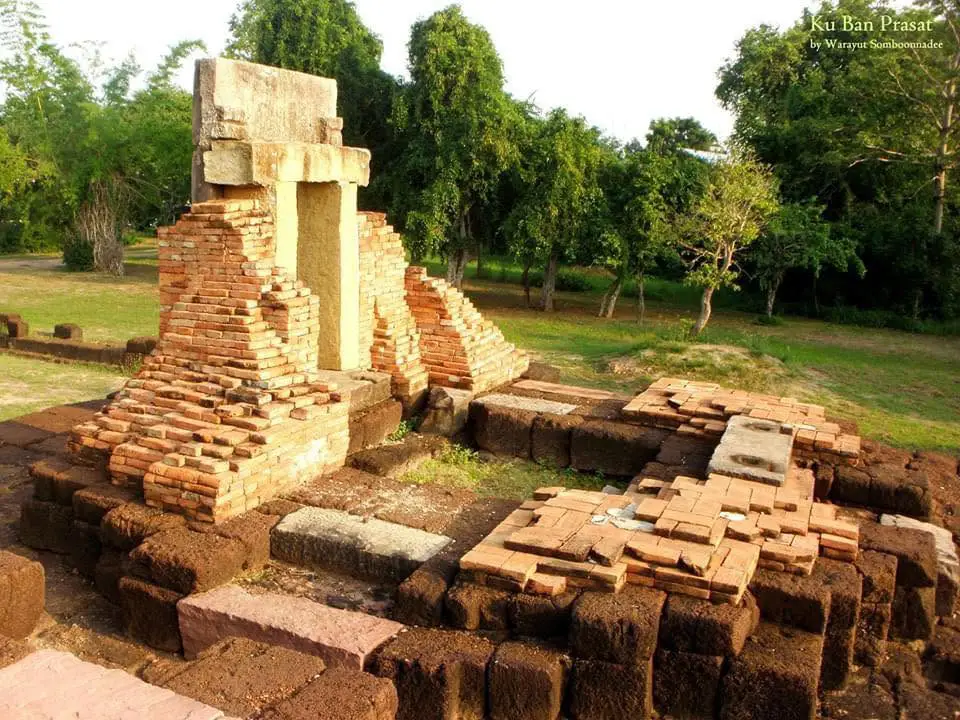
Ku Prasat
Open Days: Daily
Opening Hours: Accessible 24 hours; the recommended visiting time is 08.00 – 17.00
Admission Fee: Free admission
Prasat Ban Prasat, sometimes described as the Ku sanctuary near Wat Ban Prasat, is located in Moo 7, Ban Prasat, Mueang Prasat Subdistrict, Non Sung District, Nakhon Ratchasima Province. The monument is an ancient Khmer sanctuary constructed during the 18th Buddhist century, approximately 800 years ago, in the reign of King Jayavarman VII. It belonged to the Bayon artistic tradition and served as the religious center of an arokayasala, an ancient healthcare institution founded according to Mahayana Buddhist beliefs. Although the buildings survive only in a partial state, the principal sanctuary, bannalai, gopura gateway, laterite enclosure, approach platform, pond, sacred-water pedestal, and community guardian shrine provide valuable evidence of the relationship between religion, healing, water management, and regional administration in the ancient Khmer world.
The identity of the site requires careful clarification because two major Khmer monuments stand close together within Mueang Prasat Subdistrict. The first is Prasat Ban Prasat in Moo 7, the Bayon-period arokayasala discussed in this article. The second is Prasat Ku Ban Prasat in Moo 11, Ban Non Phatthana, approximately 500 meters to the west. Prasat Ku Ban Prasat is older and was first constructed during the 15th Buddhist century in the Koh Ker artistic tradition as a Hindu sanctuary before being modified during later periods. The statement that the sanctuary near Wat Ban Prasat is 2,000–3,000 years old does not agree with the architectural evidence. Prasat Ban Prasat itself dates to approximately 800 years ago.
Distinguishing the two monuments is essential for both navigation and historical interpretation. Although they occupy the same cultural landscape and can easily be visited on one journey, they were created during different centuries, followed different religious traditions, and used different architectural plans. Prasat Ban Prasat represents Mahayana Buddhism and Jayavarman VII’s arokayasala network during the 18th Buddhist century, while Prasat Ku Ban Prasat reflects Hindu worship and the Koh Ker tradition of the 15th Buddhist century. Visiting both places reveals several centuries of cultural and religious change within the Upper Mun River Basin.
Prasat Ban Prasat stands within an agricultural community in Non Sung District. The surrounding landscape consists largely of low plains, rice fields, local waterways, and villages whose livelihoods remain closely connected with farming. The location of an ancient healthcare institution near a settlement and a dependable source of water was practical rather than accidental. An arokayasala required water, food, medicinal plants, labor, and access routes for patients, carers, monks, officials, and travelers.
Non Sung District is one of the most archaeologically important areas of Nakhon Ratchasima Province. Sites such as Ban Non Wat and Ban Prasat Archaeological Site in Than Prasat Subdistrict preserve evidence of prehistoric farming communities, metallurgy, pottery production, long-distance exchange, and burial traditions. Prasat Ban Prasat and Prasat Ku Ban Prasat represent a later period in which the region became connected to cities, religious networks, and the political authority of the ancient Khmer Empire. The district therefore contains archaeological evidence extending across several thousand years, even though Prasat Ban Prasat itself is approximately 800 years old.
Prasat Ban Prasat was established during the reign of King Jayavarman VII, who ruled the Khmer Empire from 1181 to 1218 CE. The king followed Mahayana Buddhism and sponsored an extensive program of religious monuments, roads, bridges, traveler rest houses, water facilities, and arokayasala institutions throughout important cities and communication routes. These projects had religious significance but also strengthened regional administration, supported mobility, and presented the king as a compassionate ruler responsible for relieving the suffering of his people.
The Sanskrit-derived term arokayasala refers to a place associated with freedom from illness or the care of the sick. It should not be imagined as a modern hospital containing multi-storey wards, emergency rooms, advanced medical equipment, and permanent clinical departments. An ancient arokayasala was an institution combining a religious sanctuary, personnel, knowledge of herbs and medicine, food supplies, water, and service buildings constructed from several materials. The masonry sanctuary that survives today formed the ritual center, while timber buildings used for accommodation, food preparation, storage, or treatment have disappeared.
The Ta Prohm inscription in Cambodia records 102 arokayasala institutions within the realm of Jayavarman VII. Prasat Ban Prasat has been identified as part of this network through its architectural plan, Bayon-period style, and Mahayana Buddhist antiquities. The distribution of these institutions indicates that organized care for the sick was extended to regional cities and travel corridors rather than being restricted to the capital or royal court.
Arokayasala sanctuaries were smaller than major state temples but generally followed a recognizable plan. Common components included a principal sanctuary, a bannalai or subsidiary building, an enclosure wall, an eastern gopura gateway, and a pond outside the sacred enclosure. This standardized arrangement allows archaeologists to identify the function of a monument even when a local inscription has not survived. It also reflects central planning and the transmission of architectural knowledge across the territories influenced by Jayavarman VII.
The religious program of an arokayasala was associated with Bhaisajyaguru Vaiduryaprabha, the Medicine Buddha of Mahayana Buddhism, who symbolized the healing of physical illness and mental suffering. Ritual activities may have included chanting, offerings of medicine, water, food, and sacred objects, combined with herbal remedies, rest, nutrition, and care provided by trained personnel. This framework reflects a worldview in which religion and medicine were not separated as clearly as they are in modern institutions.
Caring for sick people required substantial resources. Water was needed for drinking, preparing meals, washing utensils, cleaning the body, boiling medicinal plants, and conducting rituals. Rice and other food had to be supplied continuously, while herbs were gathered locally or transported from other areas. Buildings were needed for rest, storage, preparation, and worship. An arokayasala therefore functioned simultaneously as a religious sanctuary, a social-service institution, and a place of support for people traveling through the region.
The location of Prasat Ban Prasat was also connected with Phimai, an important city in the Mun River Basin. Phimai contained a monumental sanctuary, moat, city walls, water systems, and routes linking it with surrounding communities. An arokayasala in the Non Sung area could support local residents and travelers moving between Phimai and communities farther west. Prasat Ban Prasat should consequently be understood as one element within a wider network of cities, routes, religion, and public infrastructure rather than as an isolated rural ruin.
The archaeological plan consists of a principal sanctuary inside an enclosure wall, a bannalai to the southeast, an eastern gopura entrance, and a pond to the northeast outside the enclosure. The eastward orientation of the principal approach corresponds with a widespread convention in ancient Khmer architecture, in which the east was associated with light, beginnings, and entry into sacred space.
The principal sanctuary was the most important building within the compound. Its upper structure collapsed, leaving the foundation and several architectural elements for study. Archaeological descriptions identify brick construction standing on a laterite foundation, with sandstone used for selected components. Each material served a different purpose. Laterite was suitable for foundations and weight-bearing structures, brick was used for walls and the sanctuary body, and sandstone was selected for door frames, thresholds, sculpture pedestals, and elements requiring strength or detailed carving.
The innermost chamber of the principal sanctuary was the garbhagriha, where sacred images were installed. Although the original images no longer stand in their ancient positions, the foundations, sculpture fragments, and archaeological finds allow researchers to reconstruct the function of the chamber. The loss of the upper tower does not remove the site’s value. The surviving foundation and plan remain direct evidence of architecture, worship, and ritual movement.
An approach platform or ceremonial pathway stood in front of the principal sanctuary. It helped organize movement toward the sacred center and may have supported processions, offerings, or preparation before worshippers entered the inner chamber. Visitors should observe changes in ground level and the direction of the approach. These details reveal the original sequence of movement even though timber posts, roofing, and other perishable elements have disappeared.
The gopura was the principal eastern gateway into the sacred compound. Passing through the entrance represented both a physical and ritual transition from the ordinary landscape into a protected religious zone. Surviving laterite masonry and doorway elements indicate the scale of the entrance and the principal east–west axis of the sanctuary.
The laterite enclosure wall surrounded the principal sanctuary and bannalai, clearly defining the ritual boundary. It was not primarily a military fortification. Its purpose was to separate sacred space from residential and agricultural activity, regulate access, and guide the movement of participants. A principal entrance on the eastern side ensured that movement toward the sanctuary followed a specific ceremonial direction.
The bannalai stands southeast of the principal sanctuary and has an entrance facing west. The building was constructed mainly from laterite. Although the term bannalai is often translated as library, the structure may have stored scriptures, ritual equipment, sacred images, medicine, or other important materials. Its location inside the enclosure demonstrates its close relationship with the ritual activities of the central sanctuary.
A rectangular pond lies northeast of the enclosure and formed an essential component of the arokayasala landscape. Ponds of this type were often lined with laterite to protect the edges and maintain their form. Water could be used for everyday needs as well as religious purification. Its proximity to the sanctuary made it possible to prepare medicine and food, wash equipment, and conduct rituals without transporting water over a long distance.
Another important discovery was a sacred-water pedestal or stone base designed to allow water to flow through a central opening. Such equipment was connected with pouring water over a sacred image or producing consecrated water. The liquid that passed through the ritual arrangement could be collected and used for worship or healing according to contemporary belief. This object provides a direct link between the pond, the water system, and the healing rituals of the arokayasala.
The principal construction materials were brick, laterite, and sandstone. Laterite is widely available in the region and can be cut while relatively soft before hardening through exposure to air. It was therefore appropriate for foundations, walls, and subsidiary buildings. Brick was lighter and suitable for the body of the central sanctuary. Sandstone could be carefully shaped and carved, making it appropriate for doorways, pedestals, and sculpture.
Building an arokayasala required organized labor and material management. Craftspeople selected clay for bricks, cut and transported laterite, obtained sandstone, prepared stable foundations, and aligned each structure with the intended orientation. The repetition of similar plans in distant locations shows that architectural models and technical knowledge were transmitted from central authorities, while local builders adapted the design to regional materials and ground conditions.
Antiquities discovered at Prasat Ban Prasat are central to the identification of its Mahayana Buddhist function. They include a Vajradhara image, a sandstone head of Avalokiteshvara, a hand holding a scripture, a hand holding a lotus, part of the foot of a standing image, and a sacred-water pedestal. These objects were not merely decorative works of art. They help reconstruct the group of sacred figures and ritual practices that once occupied the arokayasala.
Vajradhara is associated with spiritual power and advanced Mahayana Buddhist practice. The local community transferred this important object to Wat Ban Prasat for safekeeping. Its preservation demonstrates the role of the temple and community in protecting heritage discovered within their landscape. Long-term care should be coordinated with archaeological authorities so that documentation, security, conservation, and public education can be maintained.
Avalokiteshvara embodies compassion in Mahayana Buddhism. The discovery of a head and related image fragments is therefore consistent with the purpose of an institution devoted to reducing illness and suffering. A hand holding a scripture may symbolize wisdom or sacred teaching, while a hand holding a lotus represents purity and liberation from suffering. Together, these symbols gave the ancient healthcare institution physical, psychological, and spiritual dimensions.
Before conservation, trees and dense vegetation covered much of the site. Architectural elements had collapsed, and the surrounding land was used for agriculture. Some residents saw the remains only as piles of old stone because the original plan was difficult to recognize. Archaeological excavation was conducted during fiscal year 2003, followed by restoration and landscape improvement in fiscal year 2005. This work revealed the plan of the principal sanctuary, enclosure, gopura, bannalai, and related arokayasala features.
Restoration does not mean rebuilding the sanctuary until it resembles a new replica. Its purpose is to stabilize original material, strengthen vulnerable sections, and arrange surviving elements so that visitors can understand the plan without destroying archaeological evidence. Leaving the principal sanctuary as a foundation is therefore an honest presentation of its surviving condition rather than a failure to reconstruct it.
Prasat Ban Prasat is now an important historical learning site for the community and Nakhon Ratchasima Province. Conservation involves Fine Arts Office 10, Nakhon Ratchasima, Mueang Prasat Subdistrict Administrative Organization, Wat Ban Prasat, and the local community. Archaeological authorities provide technical guidance and monitor the monument, while local organizations and residents help maintain the landscape, cleanliness, and daily awareness of possible damage.
Beside the sanctuary stands the village guardian shrine known as Ta Pu Chao Prang. It expresses the continuing relationship between the archaeological monument and contemporary community belief. Residents conduct an annual worship ceremony in May to honor the guardian associated with the village. The ceremony allows a sanctuary formerly connected with Mahayana Buddhism to retain a spiritual role in modern society, even though the form of belief has changed over time.
The Ta Pu Chao Prang ceremony should not be described as an unchanged ritual transmitted directly from Jayavarman VII’s period. It is a later community interpretation that creates a new relationship between residents and the ancient monument. Local people experience the sanctuary as a sacred and protective place, while archaeologists study it as historical evidence. These perspectives can coexist when ritual activity respects and does not damage the architecture.
Although the monument is near Wat Ban Prasat, the archaeological sanctuary is not an active monastic building used by resident monks for regular Buddhist ceremonies. It therefore does not have an abbot responsible specifically for the ancient monument. The caretakers listed in this article are heritage authorities, the local administrative organization, the temple as a community institution, and residents rather than an unverified individual abbot.
Prasat Ku Ban Prasat in Moo 11, Ban Non Phatthana, is approximately 500 meters west and should be included in the same excursion. The older complex contains three brick towers arranged north–south on a shared laterite base, together with an enclosure wall, gopura, bannalai, cross-shaped building, open hall, and remains of a moat. Its earliest phase belongs to the Koh Ker tradition during the reign of Jayavarman IV in the 15th Buddhist century, followed by modifications in later Khmer periods.
Comparing the two places reveals significant differences. Prasat Ku Ban Prasat has three principal towers and began as a Hindu sanctuary, while Prasat Ban Prasat has a single principal sanctuary accompanied by the standardized elements of an arokayasala and follows Mahayana Buddhism. The comparison demonstrates that the expression “Khmer sanctuary” covers many architectural types and does not imply that every monument had the same religious function.
A visit to Prasat Ban Prasat should begin outside the enclosure by observing the pond and its relationship with the settlement. Visitors can then enter through the eastern gopura, follow the enclosure wall and central axis, and proceed toward the principal sanctuary. This sequence reveals the transition from ordinary space to the sacred center and is more informative than walking directly to the foundation for a photograph.
At the principal sanctuary, visitors should observe the height of the foundation, construction materials, doorway alignment, and location of the garbhagriha. These can then be compared with the bannalai to the southeast. The central sanctuary contained the primary sacred images, while the bannalai supported related ritual functions. Understanding the complete arrangement is more valuable than judging the monument only by its size or surviving height.
The pond and sacred-water pedestal deserve particular attention because they demonstrate the practical and ritual importance of water. Travelers can consider how the same water source supported medicine, food preparation, washing, and the ceremonial pouring of water over sacred images. This combination is one of the characteristics that helps distinguish an arokayasala from a sanctuary without a healthcare function.
Information signs explain the monument’s history, plan, and archaeological discoveries. Reading the signs before and after walking through the remains allows visitors to compare written interpretation with the surviving evidence. Identifying brick, laterite, and sandstone or locating the bannalai and pond makes the experience more meaningful than using the site only as a photography stop.
Visitors must not climb the foundations, sit on the enclosure wall, move stones, write on surfaces, or remove fragments from the area. A brick or stone may appear insignificant, but its original position can contain archaeological information. Moving even a small object destroys part of its relationship with the surrounding evidence and may prevent accurate future study.
Incense, candles, and offerings should be placed only in areas designated by the community. Hot objects, oil, wax, paint, and food should not be placed on brick or laterite because heat and staining damage ancient surfaces. Cloth, nails, or heavy objects must not be attached to original masonry. Respect for a sacred place must be combined with respect for its physical conservation.
Photography is generally possible when no temporary restriction is posted, but visitors should remain on safe ground and avoid climbing for elevated viewpoints. Drone use requires appropriate permission. Images shared online should identify the location correctly as Prasat Ban Prasat in Moo 7 rather than Prasat Ku Ban Prasat in Moo 11, preventing further circulation of inaccurate information.
The monument is an open-air archaeological site within a village rather than a large visitor center. Facilities are consequently limited. Travelers should bring drinking water, a hat, an umbrella, insect repellent, and sun protection. Shops, air-conditioned facilities, and regularly serviced restrooms are easier to find in Non Sung town than immediately beside the monument.
Online place information lists the site as accessible 24 hours because there is no ticket gate and the monument stands in an open community area. The recommended visiting time is nevertheless 08.00–17.00, when daylight makes uneven ground visible and a visit is less likely to disturb residents. Night visits are not advisable because lighting and permanent staff presence are limited.
Morning is the most comfortable period because temperatures are lower and angled sunlight reveals the texture of brick and laterite. Late afternoon offers attractive light for photography but requires sufficient time before sunset. The cool season from November to February is generally most comfortable, while March to May can be extremely hot and midday visits should be avoided.
The rainy season creates a green landscape, but grass, soil, and the area near the pond may become slippery. Shoes with good grip are recommended. Visitors should remain away from the pond edge and must not climb the foundations after rain. Water drainage around an ancient monument is also a conservation concern, so restricted areas and temporary barriers must be respected.
Older travelers and people with limited mobility can view much of the monument from the surrounding open area, although sections consist of uneven soil and grass. Continuous modern ramps are not available throughout the compound. A companion may be helpful, particularly during wet weather. Vehicles should be parked without obstructing village traffic and must not be driven close to the archaeological foundations.
Families can use the site as an outdoor classroom. Children can identify three building materials—brick, laterite, and sandstone—and locate five key features: the principal sanctuary, bannalai, gopura, enclosure wall, and pond. Adults should explain that an arokayasala was an ancient healthcare institution, not a military castle or royal residence.
Schools and organized educational groups should contact Fine Arts Office 10 or Mueang Prasat Subdistrict Administrative Organization in advance. A knowledgeable guide can explain the difference between the two nearby Khmer monuments and introduce the concepts of an arokayasala, Bayon art, Mahayana Buddhism, and the regional policies of Jayavarman VII.
Prasat Ban Prasat and Prasat Ku Ban Prasat can be visited together because they are separated by approximately 500 meters. Allow at least 1.5–2 hours for both. Beginning with the arokayasala at Prasat Ban Prasat and continuing to the three-towered Koh Ker sanctuary provides a clear comparison of age, plan, and religious tradition.
Ban Non Wat Archaeological Site expands the historical context of Non Sung District. It preserves evidence of prehistoric settlement, burials, metallurgy, and exchange. Combining Ban Non Wat with Prasat Ban Prasat allows travelers to follow a development from Metal Age agricultural communities to a society containing organized cities, religious institutions, and regional healthcare infrastructure.
Ban Prasat Archaeological Site in Than Prasat Subdistrict should not be confused with Prasat Ban Prasat in Mueang Prasat Subdistrict. The former is an open-air excavation site containing human skeletons and prehistoric community evidence. The latter is a Jayavarman VII-period arokayasala. Including the subdistrict and district in search terms is the most reliable way to distinguish them.
Phimai Historical Park and Phimai National Museum are suitable continuation points. Travelers can first examine the community-level arokayasala at Prasat Ban Prasat, then explore the monumental city sanctuary at Phimai, and finally study sculpture, inscriptions, and archaeological objects in the museum. The route connects a small regional institution with a major urban center of ancient Khmer culture.
A half-day itinerary can include Prasat Ban Prasat and Prasat Ku Ban Prasat in the morning, followed by lunch in Non Sung town. Ban Non Wat may be added when time permits. This route covers a relatively compact area and allows archaeology enthusiasts to examine details without rushing.
A full-day itinerary can begin with the two Mueang Prasat monuments, continue to Ban Non Wat or Ban Prasat Archaeological Site in Than Prasat, and finish at Phimai Historical Park and Phimai National Museum. Opening days and hours for the museum and historical park should be checked before departure because those institutions maintain fixed schedules and closure days.
Most restaurants are concentrated in Non Sung town, approximately 10–15 minutes from the monument. Options include local meals, noodles, hot-pot restaurants, bakeries, and cafés. Travelers should telephone smaller businesses before visiting because operating hours may change according to holidays, staffing, or ingredient availability.
The closest accommodation options are small resorts in Mueang Prasat and Ban Non Phatthana. They are suitable for travelers wishing to begin an archaeological itinerary early in the morning. Non Sung town provides easier access to restaurants, markets, and convenience stores, while Phimai is a practical overnight base for visitors continuing to the historical park and museum.
Getting There from central Nakhon Ratchasima involves following Highway 2, or Mittraphap Road, toward Non Sung District and continuing on local roads to Mueang Prasat Subdistrict and Ban Prasat, Moo 7. The driving distance is approximately 45–50 kilometers. Search for “Prasat Ban Prasat, Mueang Prasat” or use the approximate coordinates 15.1952, 102.1770 to avoid being directed to Ban Prasat Archaeological Site in Than Prasat Subdistrict.
From Non Sung town, follow local roads toward Mueang Prasat Subdistrict for approximately 8–10 kilometers. The route passes through agricultural land and residential communities. Drivers should watch for motorcycles, farm vehicles, pedestrians, and animals. On reaching Ban Prasat, follow signs for the village, Wat Ban Prasat, and the archaeological monument.
Public-transport travelers can reach Non Sung by bus or train and arrange a local vehicle to Ban Prasat. There is no frequent scheduled service operating directly to the monument. Return transport, waiting time, and fares should be agreed in advance, especially when combining the visit with Prasat Ku Ban Prasat, Ban Non Wat, or other archaeological places.
Foreign travelers may encounter several English names, including Prasat Ban Prasat, Ban Prasat Arokayasala, and the Ku sanctuary near Wat Ban Prasat. Using the Thai name “ปราสาทบ้านปราสาท” together with Mueang Prasat Subdistrict and Non Sung District will distinguish the place from Ban Prasat Archaeological Site in Than Prasat and Prasat Ku Ban Prasat in Ban Non Phatthana.
Prasat Ban Prasat is important because it demonstrates that ancient Khmer civilization was not represented only by monumental state temples and royal ceremonies. Small community sanctuaries linked religion, healthcare, water, food, and transportation. The arokayasala system reveals a society capable of allocating resources and organizing assistance for sick people across a regional network.
The monument’s incomplete condition does not reduce its value. The sanctuary foundation identifies the position of sacred images, the enclosure defines ritual space, the bannalai represents subsidiary functions, the pond records water management, and the antiquities communicate ideals of compassion, wisdom, and healing. Read together, these elements form a historical document created from brick, laterite, sandstone, water, and community memory.
Responsible travel will allow the site to remain an educational resource. Visitors should read the information, distinguish the monuments correctly, respect the community guardian shrine, avoid disturbing residents, and protect the original structures. Photographs and online descriptions should help correct the inaccurate claim that the monument is 2,000–3,000 years old and instead explain its genuine significance as an approximately 800-year-old arokayasala from the reign of Jayavarman VII.
| Name | Prasat Ban Prasat |
| Alternative Names | Ban Prasat Arokayasala, Ku Sanctuary near Wat Ban Prasat |
| Thai Name | ปราสาทบ้านปราสาท |
| Location | Moo 7, Ban Prasat, Mueang Prasat Subdistrict, Non Sung District, Nakhon Ratchasima Province |
| Address | Ban Prasat, Moo 7, Mueang Prasat, Non Sung, Nakhon Ratchasima 30160, Thailand |
| Coordinates | Approximately 15.1952, 102.1770 |
| Monument Type | Religious sanctuary of an arokayasala healthcare institution founded according to Mahayana Buddhist beliefs |
| Period and Age | 18th Buddhist century, reign of King Jayavarman VII, Bayon artistic tradition, approximately 800 years old |
| Construction Materials | Brick, laterite, and sandstone |
| Highlights | One of the arokayasala institutions associated with Jayavarman VII’s network of 102 ancient hospitals, illustrating the relationship between religion, healthcare, water management, and communities in the Mun River Basin |
| Important Antiquities | Vajradhara image, sandstone head of Avalokiteshvara, hand holding a scripture, hand holding a lotus, foot fragment from a standing sculpture, and sacred-water pedestal |
| Location of Vajradhara Image | Wat Ban Prasat |
| Main Areas / Zones | 1. Principal sanctuary and garbhagriha 2. Ceremonial approach platform 3. Bannalai southeast of the principal sanctuary 4. Eastern gopura gateway 5. Laterite enclosure wall 6. Pond northeast of the enclosure 7. Sacred-water pedestal and water-ritual area 8. Ta Pu Chao Prang guardian shrine and community courtyard 9. Information signs and surrounding archaeological landscape |
| Annual Tradition | The community conducts an annual worship ceremony for Ta Pu Chao Prang in May |
| Conservation History | Archaeological excavation in fiscal year 2003 and restoration with landscape improvement in fiscal year 2005 |
| Caretaker | Fine Arts Office 10, Nakhon Ratchasima, in cooperation with Mueang Prasat Subdistrict Administrative Organization, Wat Ban Prasat, and the Ban Prasat community |
| Current Status | Open to the public, functioning as a community historical learning site, and periodically maintained for conservation |
| Open Days | Daily |
| Opening Hours | Accessible 24 hours; recommended visiting time 08.00 – 17.00 |
| Admission Fee | Free admission |
| Facilities | Information signs, an open walking area, and limited community parking. Visitor facilities are limited, so travelers should bring drinking water and sun protection. |
| Recommended Visit Duration | Approximately 45 – 90 minutes, or 1.5 – 2 hours when combined with Prasat Ku Ban Prasat |
| Travel Information | From central Nakhon Ratchasima, follow Highway 2 toward Non Sung and continue on local roads to Mueang Prasat and Ban Prasat, Moo 7. The distance is approximately 45 – 50 km, or approximately 8 – 10 km from Non Sung town. |
| Site Contact Number | +66 89 532 5478 |
| Caretaker Contact Number | Fine Arts Office 10, Nakhon Ratchasima: +66 44 471 518 |
| Nearby Tourist Attractions | 1. Prasat Ku Ban Prasat, Ban Non Phatthana, approximately 1 km; Fine Arts Office 10 Tel. +66 44 471 518 2. Ban Non Wat Archaeological Site, approximately 18 km 3. Ban Prasat Archaeological Site, Than Prasat Subdistrict, approximately 26 km; Fine Arts Office 10 Tel. +66 44 471 518 4. Phimai Historical Park, approximately 39 km, Tel. +66 44 471 568 5. Phimai National Museum, approximately 39 km, Tel. +66 44 471 167 |
| Nearby Restaurants | 1. marchmayRo Cafe, approximately 10 km, Tel. +66 87 963 5059 2. Ton Rak Cake Non Sung, approximately 10 km, Tel. +66 97 135 6197, +66 97 335 5428 3. Mesa Shabu & Grill, approximately 10 km, Tel. +66 64 912 0542 4. Chaew Hon Non Sung, approximately 10 km, Tel. +66 95 664 8263 5. PunThai Coffee Non Sung Market, approximately 10 km, Tel. +66 92 275 2913 |
| Nearby Accommodations | 1. Ton Rak Resort, Ban Non Phatthana, approximately 2 km, Tel. +66 86 877 7295 2. Leelawadee Resort Non Sung, approximately 4 km, Tel. +66 87 960 0442 3. Attitude The Resort Non Sung, approximately 11 km, Tel. +66 90 975 3230 4. 212 Saeng Khan Resort, approximately 11 km, Tel. +66 83 378 9159 5. My Home Resort, Don Chomphu, approximately 18 km, Tel. +66 88 359 0599 |
Frequently Asked Questions (FAQ)
Q: Where is Prasat Ban Prasat located?
A: It is located in Moo 7, Ban Prasat, Mueang Prasat Subdistrict, Non Sung District, Nakhon Ratchasima Province, at approximately 15.1952, 102.1770.
Q: Is Prasat Ban Prasat really 2,000–3,000 years old?
A: No. The monument is a Bayon-period arokayasala constructed during the 18th Buddhist century in the reign of King Jayavarman VII and is approximately 800 years old. Non Sung District contains other prehistoric sites that are considerably older.
Q: Are Prasat Ban Prasat and Prasat Ku Ban Prasat the same place?
A: No. Prasat Ban Prasat is the 18th-century Buddhist arokayasala in Moo 7. Prasat Ku Ban Prasat is an older sanctuary in Moo 11, Ban Non Phatthana, approximately 500 meters away, with an initial construction phase dating to the 15th Buddhist century.
Q: What was an arokayasala?
A: An arokayasala was an ancient healthcare institution established under Jayavarman VII. It combined a religious sanctuary with personnel, medicine, herbs, water, food, and service buildings. The surviving masonry structure was its ritual center.
Q: What are the opening hours and admission fee?
A: The open-air site is accessible daily and is listed as open 24 hours. Admission is free. Travelers should visit between 08.00 and 17.00 for daylight, safety, and respect for the community.
Q: What can visitors see at Prasat Ban Prasat?
A: Important features include the principal sanctuary foundation, ceremonial platform, bannalai, gopura, laterite enclosure, pond, sacred-water pedestal, Ta Pu Chao Prang shrine, and information signs.
Q: Where are the important antiquities from the site?
A: The Vajradhara image is kept at Wat Ban Prasat. Current information about other excavated objects should be requested from Fine Arts Office 10, Nakhon Ratchasima.
Q: How long should travelers spend at the monument?
A: Allow approximately 45 – 90 minutes for Prasat Ban Prasat. A combined visit with nearby Prasat Ku Ban Prasat should take at least 1.5 – 2 hours.
 Category: ●Art, Culture and Heritage
 Group: ●Historical Sites and Monuments
Last Update : 3 MonthAgo
 Last Update : 3 MonthAgo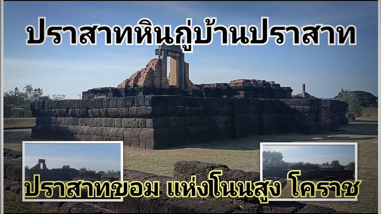
 Click to Access the Navigation Map GPS
 Historical Sites and Monuments(20)
 Landmarks and Memorials(5)
 Art, Craft Centres, Tradition(7)
 Museums(6)
 Art Gallery(1)
 Educational Places
 Educational Gardens, Farm(4)
 Places of Worship
 Temple(29)
 Mosque(1)
 Other Sacred Sites(6)
 Research and Development
 Royal Project(3)
 Suburban Living
 Village, Community(6)
 Local Market(4)
 Floating Market(1)
 Nature and Wildlife
 National Parks and Marine Reserves(3)
 Mountain (Doi)(5)
 Dam, Reservoir, Lake(8)
 Waterfalls(9)
 Hot Springs(1)
 Caves(2)
 Flower Field(1)
 River, Canal(8)
 Bays and Beaches(2)
 Other natural attractions(3)
 Entertainment and Agricultural
 Zoos and Aquariums(2)
 Animal camps and shows(1)
 Farms, Parks and Ecotourism(21)
 Waterpark(4)
 Outdoor and Adventure Activities(6)
 Shopping
 Shopping and Night Market(2)
 Travel Articles, Recipes
 Travel Review, Food Review(6)


