
lovethailand home >Northeastern Travel Attractions >Nakhon Ratchasima Travel Attractions >Khong >Ban Prang > Prang Ban Prang
TL;DR: Prang Ban Prang is located at Ban Prang Nakhon Community, Ban Prang Subdistrict, Khong District, Nakhon Ratchasima, open Daily; advance contact with the community is recommended, hours 08.30 – 16.30.
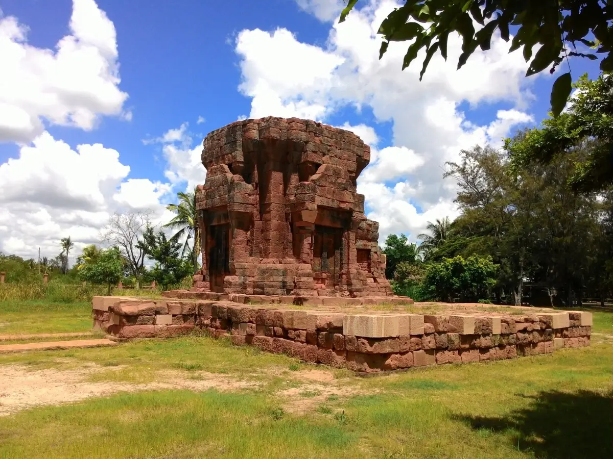
Prang Ban Prang
Open Days: Daily; advance contact with the community is recommended
Opening Hours: 08.30 – 16.30
Prang Ban Prang in Nakhon Ratchasima Province, also known as Prasat Ban Prang, is an ancient Khmer sanctuary situated in the Ban Prang Nakhon community of Ban Prang Subdistrict, Khong District. The monument was constructed as a Hindu religious site during the 17th Buddhist century, corresponding to the transitional period between the late Baphuon and early Angkor Wat artistic styles. Its age is broadly comparable with that of the principal sanctuary at Phimai. The surviving tower was built mainly from laterite, with sandstone used for important architectural components such as the doorway. Although much of the upper structure has collapsed, the central body and part of an upper tier remain sufficiently intact to reveal the original proportions of the building.
Archaeological descriptions indicate that the original complex consisted of 3 sanctuary towers standing on a shared platform and arranged along a north–south axis. Over many centuries, the structures deteriorated at different rates, leaving one tower as the most prominent surviving element today. A U-shaped moat surrounded the sanctuary group, with access routes left open on the eastern and western sides. The monument was also related to a wider water-management landscape that is now presented through the community story of Barai Sawan, traditional agricultural areas, and the cultural environment of Ban Prang Nakhon.
There is no formal admission charge for visiting the archaeological monument. The site is particularly suitable for travelers interested in Khmer architecture, the history of the lower northeastern region, Hindu religious traditions, rural communities, and locally managed cultural tourism. A general archaeological visit takes approximately 45–90 minutes. Travelers who wish to include the barai, old Korat houses, traditional food, local crafts, community transport, or a homestay should allow at least half a day and arrange the program in advance. Guided activities, meals, workshops, and accommodation are charged separately according to the selected community package.
The name Prang Ban Prang can cause confusion because several monuments and communities in Nakhon Ratchasima use similar names. The site described here is located in Ban Prang Nakhon, Ban Prang Subdistrict, Khong District. It is not the similarly named monument in Huai Thalaeng, Chok Chai, or another district. Travelers should search for “Prasat Ban Prang, Khong District” or use the coordinates 15.4919163, 102.0986684 to avoid being directed to the wrong location.
The importance of Prang Ban Prang extends beyond its age. It provides evidence that the area now known as Khong District was once connected to the political, religious, commercial, and cultural networks of Khmer communities on the Khorat Plateau. Constructing a sanctuary from laterite and sandstone required skilled builders, organized labor, knowledge of structural engineering, quarrying, and transportation. The presence of the monument therefore indicates that this rural landscape was linked to wider regional centers and established routes of communication.
The monument dates to a period when Khmer architecture was developing from the Baphuon tradition toward the early Angkor Wat style. Characteristic features of this era included shrine towers centered on a sacred inner chamber, the use of sandstone for doorways and finely shaped components, and the extensive use of laterite for foundations and structural walls. Prang Ban Prang is therefore a valuable small-scale example through which visitors can understand broader architectural developments without examining only the largest and most elaborate temple complexes.
Describing Prang Ban Prang as being similar in age to the principal sanctuary at Phimai does not mean that the 2 monuments had identical functions, size, or artistic detail. The comparison refers mainly to their general chronological and architectural context. The surviving sandstone doorway and the arrangement of openings on the eastern façade show certain proportions that can be compared with architectural work at Phimai, although Prang Ban Prang was a considerably smaller sanctuary serving a local community.
Phimai was a major urban and religious center with a complex plan, extensive ceremonial spaces, and numerous carved architectural elements. Prang Ban Prang was a much smaller community sanctuary. Comparing them helps travelers understand the hierarchy of Khmer religious architecture, from large regional centers to smaller sacred sites distributed among agricultural settlements and along communication routes.
In the general architectural symbolism of Hindu temples, the principal sanctuary represented a sacred cosmic center and housed an image of a deity. The inner chamber, or sanctuary cell, was the most important ritual space. However, the principal publicly available archaeological descriptions do not identify with certainty the specific deity worshipped at Prang Ban Prang. It is therefore more accurate to describe the monument as a Hindu sanctuary without assigning it to Shiva, Vishnu, or another deity unless further archaeological evidence becomes available.
The original plan consisted of 3 towers built upon the same raised platform and aligned north to south. This arrangement reflects deliberate architectural planning in which several sacred buildings were treated as parts of a single composition. Although the towers no longer survive equally well, the shared foundation and remaining architectural materials help define the boundaries of the original sanctuary group.
The most visible surviving tower has lost much of its upper section, but the central body and part of an additional tier remain. Compared with many small Khmer monuments that have collapsed almost completely to foundation level, Prang Ban Prang preserves a substantial portion of its original mass. The remaining laterite walls, entrance frame, and upper masonry allow visitors to imagine the scale and vertical form of the original tower.
The central chamber was a relatively small room intended to contain a sacred image rather than accommodate a large congregation. Access to the sacred interior followed a controlled progression from the surrounding area, across the raised platform, through the doorway, and into the inner chamber. Ceremonies involving larger groups would have taken place outside the confined shrine room, with only officiants or selected participants entering the most sacred space.
On the eastern side, the tower has window-like openings or recessed architectural spaces on both sides of the entrance. These features provide depth to the façade and would have allowed some light to reach the front interior area. Although their upper sections are damaged, the surviving walls still reveal the relationship between the openings, the doorway, and the mass of the sanctuary. Such details are especially valuable because many small Khmer ruins have lost too much of their wall structure to preserve comparable evidence.
The doorway was framed with sandstone, a material finer and easier to shape accurately than laterite. Sandstone was well suited to door frames, decorative columns, lintels, and surfaces intended to receive carved ornament. Although much of the original decoration above the entrance has disappeared, the proportions of the surviving frame display similarities to the architectural vocabulary seen at Phimai.
The original superstructure would have risen in receding tiers, creating a tall and visually dominant sacred tower. When the upper levels collapsed, many stones fell around the platform or were reused and rearranged during later periods. The present appearance is therefore the result of natural deterioration, structural collapse, changing religious use, later community activity, and modern conservation work.
Laterite was the principal building material. This iron-rich tropical material can be cut into blocks while relatively soft below ground and hardens further after exposure to the air. Ancient builders used it for foundations, walls, and large structural masses. Its porous texture and reddish-brown color give the monument a distinctive appearance that blends naturally with the soil and agricultural landscape of the Khorat Plateau.
Constructing with laterite required careful cutting, sizing, and placement of blocks. Builders had to distribute the weight of the walls and upper tiers without relying on modern cement. Visitors can observe joints, layers, and wall thickness as evidence of this construction system. Pulling, climbing, or attempting to examine loose blocks by hand may disturb the structural balance and must be avoided.
Sandstone served a different purpose. It was used where both strength and precision were required, particularly around entrances and other visually important architectural points. The combined use of laterite and sandstone demonstrates a sophisticated understanding of material properties. Laterite formed the structural body, while sandstone marked the ceremonial transition between the outside world and the sacred chamber.
A roughly square enclosure wall surrounds the sanctuary area, but the eastern entrance does not preserve a monumental gopura of the type seen at some larger Khmer temples. Archaeological descriptions suggest that stones from collapsed structures may have been collected and rearranged to create or repair sections of the enclosure during a later period. The wall visible today may therefore include both ancient construction and subsequent modification.
The absence of a clearly preserved gopura does not mean that access was unregulated. Openings or pathways through the enclosure still directed movement into the compound. The principal routes were located on the eastern and western sides. As in many Khmer sanctuaries, the east was especially important because of its association with sunrise and the ceremonial approach toward the sacred building.
A U-shaped moat surrounded the sanctuary group, leaving access on the eastern and western sides. Water helped manage drainage and define the sacred compound, while also carrying symbolic meaning within Khmer religious landscapes. Viewed together, the raised platform, central towers, moat, and controlled approach created a clear distinction between the sacred center and the surrounding settlement.
Beyond the immediate sanctuary area, a long water feature aligned approximately north–south forms part of the community landscape. The term barai is commonly used for large reservoirs associated with Khmer settlements, irrigation, agriculture, and sacred geography. However, the present water landscape has been affected by sedimentation, agricultural use, settlement development, and modern improvements. Visitors should not assume that every visible bank or boundary remains unchanged from the period when the temple was first constructed.
Barai Sawan has become an important component of the Ban Prang Nakhon community-tourism route. A bamboo bridge extends into the wetland and agricultural landscape, giving visitors a broad view that contrasts with the dense masonry of the sanctuary. Together, the monument and barai illustrate the relationship between sacred architecture, water resources, farming, and settlement. Boat trips, community vehicles, welcoming ceremonies, and other activities are not guaranteed every day and must be arranged in advance.
The site did not immediately lose all religious importance after the political influence of the ancient Khmer communities declined. During the 20th–21st Buddhist centuries, corresponding to the Ayutthaya–Lan Xang cultural period, a rectangular brick building was added to the east of the sanctuary platform. Its floor and walls were built from brick, while the posts and roof structure were wooden and covered with fired-clay tiles.
This later building probably functioned as a Buddhist viharn or image hall. Its construction indicates that later communities did not simply abandon the Hindu sanctuary. Instead, they adapted the old sacred landscape to Buddhist worship. The Khmer towers remained as a respected focal point, while a new building was added to support the religious practices of a later population.
The transition from Hindu to Buddhist use did not require complete destruction of the earlier monument. Communities could preserve the ancient tower, add a viharn in front of it, and reinterpret the surrounding landscape. Similar patterns are found at several Khmer sites in northeastern Thailand and help explain why many ancient sanctuaries continued to be respected by Thai and Lao-speaking Buddhist communities.
What visitors see today is therefore not a frozen image of the original construction date. The monument contains several historical layers: the ancient Khmer sanctuary, the later Buddhist building, rearranged enclosure stones, changing water systems, the growth of the modern village, archaeological protection, restoration, and community-tourism development. Understanding these layers prevents the mistaken assumption that every surviving element belongs to a single period.
The Fine Arts Department registered Prang Ban Prang as a national ancient monument in the Royal Gazette, Volume 53, Part 34, dated 27 September 1936. Registration protects the monument under Thai heritage law. Excavation, alteration, removal of stones, or any activity capable of damaging archaeological remains requires official permission.
The protected archaeological boundary was formally declared on 15 September 1983 in the Royal Gazette, Volume 100, Part 36. The registered area covers 6 rai, 1 ngan, and 80 square wah. This protected zone is important because archaeological conservation includes not only the visible tower but also foundations, the moat, the enclosure, buried evidence, and the surrounding historical landscape.
In 2015, the Fine Arts Department implemented a restoration and landscape-improvement project at Prang Ban Prang. The final project inspection took place on 3 September 2015. The work was intended to stabilize the monument, improve the surrounding area, and make the site more suitable for education and cultural tourism while retaining authentic materials and archaeological evidence.
Recent official information confirms continuing maintenance. Personnel from the 10th Regional Office of Fine Arts cleared vegetation and cleaned the archaeological area on 1–2 July 2026. The named monument maintenance officer was Ms. Suphan Baipho, working with an official team. This current activity confirms that the monument remains open, actively cared for, and recognized as a cultural learning and tourism site.
Managing an archaeological monument inside a rural community is different from operating a major historical park. There may be no permanent ticket office, full-time guide, or large visitor center. Management depends on cooperation among the 10th Regional Office of Fine Arts, Ban Prang local authorities, community leaders, and the Ban Prang Nakhon tourism group. Large parties, researchers, commercial photographers, and visitors requiring organized activities should make advance arrangements.
Ban Prang Nakhon is notable for connecting its ancient monument with living community culture. A community itinerary may include the Khmer sanctuary, old Korat houses, the barai, agricultural landscapes, traditional crafts, local food, and welcoming activities organized by residents. This approach allows tourism revenue and cultural pride to remain within the village rather than treating the monument as an isolated archaeological object.
Traditional Korat houses demonstrate local wooden architecture, raised-floor construction, natural ventilation, and the organization of domestic space for agricultural families. Some houses are many decades old and preserve important elements of regional design. Moving from a stone Khmer sanctuary to a traditional Korat house enables travelers to observe several centuries of settlement history within the same community.
Local food is another important part of the experience. Community programs have included Korat noodles, traditional snacks, chili pastes, local dishes, and food-processing activities. These meals and workshops are not necessarily available as a permanent restaurant service every day. Travelers should contact the community in advance to confirm group size, menu, price, timing, and the availability of residents who organize the activity.
Rattanaphiman Shrine at Ban Prang Thong is sometimes used as a starting point for organized community visits. It contains modern images of Hindu deities such as Shiva, Kali, and Ganesha according to contemporary local devotion. This is a living community shrine and not an original architectural component of Prang Ban Prang. Foreign visitors should distinguish modern devotional practices from archaeological conclusions concerning the ancient sanctuary.
Local narratives about spiritual power, solar alignment, sacred energy, or unusual phenomena form part of the community’s modern beliefs and cultural memory. These stories are valuable for understanding how present-day residents relate to the monument, but they should not be treated as substitutes for archaeological evidence. A responsible visit can respect oral traditions while clearly separating belief from established architectural and historical findings.
A useful visit begins outside the moat, where the relationship among the village, water system, and sanctuary can be observed. Enter from the eastern side and examine the shared platform of the original 3 towers. Identify the positions of structures that have collapsed and focus on the tower that remains most visible. From a safe distance, compare the rough laterite masonry with the smoother sandstone doorway.
Continue slowly around the sanctuary without stepping onto foundations. Observe wall thickness, openings, changes in ground level, and the arrangement of fallen materials. Examine the enclosure, remembering that some stones may have been rearranged in a later period. The eastern side also contains evidence of the brick Buddhist building added during the Ayutthaya–Lan Xang era.
The most comfortable time to visit is between 08.30 and 10.30, when temperatures are lower and morning light emphasizes the eastern façade, laterite texture, and sandstone doorway. Late afternoon between approximately 15.00 and 16.30 provides angled light suitable for photography. Visitors should leave before the community service period ends and should not remain around the monument after dark without local permission.
November to February generally offers the most pleasant weather. During the hot season, carry drinking water, a hat, an umbrella, and sun protection. Rainy-season vegetation creates an attractive green landscape around the barai and fields, but soil surfaces, laterite blocks, and uneven paths can become slippery. Closed shoes with good grip are recommended.
The eastern view is one of the best photographic positions because it records the doorway, side openings, and remaining height of the tower in a single composition. An oblique side view reveals wall thickness, while a wider view from the moat explains the overall plan. Never stand on the platform, loose laterite blocks, or enclosure wall to gain elevation. Repeated pressure and vibration accelerate deterioration.
Drone use, commercial filming, organized events, and large equipment require advance permission from the relevant heritage and local authorities. Free admission does not grant unrestricted use of the archaeological site. Visitors planning professional work should contact the 10th Regional Office of Fine Arts and the community before arriving.
Basic visitor rules include no climbing, no movement of stones, no graffiti, no fire close to the masonry, and no removal of objects. If a traveler notices pottery fragments, carved stone, or an unusual archaeological object, it should remain exactly where it was found. Photograph it without touching it and inform the caretaker or local coordinator.
Visitors should remove their own rubbish, avoid throwing food into the moat or barai, and refrain from damaging vegetation. Conservation involves more than preserving masonry. Water, trees, soil, wildlife, and the quiet character of the village all contribute to the meaning and long-term survival of the heritage landscape.
Facilities are those of a community attraction rather than a major historical park. Parking is available in areas designated by residents, and the monument is explored on foot in an open-air setting. Community guides, meals, workshops, and accommodation can be arranged in advance. Visitors should bring water, necessary medication, cash, and any personal items they may require.
Older visitors can observe much of the monument from relatively level outer areas, but uneven soil, stone foundations, and changes in ground level may restrict wheelchair access. Travelers with mobility requirements should contact the community to ask about the closest parking point and available assistance. Toilets and shops are found within the village rather than in a large dedicated visitor building beside the sanctuary.
Getting There from Nakhon Ratchasima city is most convenient by private or rental car. Follow Highway 205 toward the northern districts of the province and continue on local roads to Ban Prang Subdistrict, Khong District. The journey is approximately 70–80 km and normally takes around 1 hour 20 minutes to 1 hour 45 minutes, depending on the starting point, traffic, and road conditions.
Near Ban Prang, enter “Prasat Ban Prang, Khong District” or the coordinates 15.4919163, 102.0986684 into the navigation system. Searching only for Prang Ban Prang may produce results for a similarly named monument elsewhere in Nakhon Ratchasima. The final approach passes through villages and agricultural land, so drivers should slow down and watch for motorcycles, farm vehicles, pedestrians, and animals.
Public transportation can be used to reach Khong District or Bua Yai, followed by a locally hired vehicle. Ban Prang Subdistrict is approximately 30 km from central Khong District, and scheduled transport into the community is limited. Agree on the fare and return pickup time before leaving town, and keep the driver’s telephone number because finding another vehicle at the monument may be difficult.
A half-day itinerary can begin with the sanctuary in the morning, followed by the old Korat houses and community-learning areas. Continue to Barai Sawan and the bamboo bridge. With advance arrangements, visitors may have a local meal or join a community workshop. This compact route combines archaeology, vernacular architecture, food heritage, agriculture, and local water management.
A full-day route can add Rattanaphiman Shrine at Ban Prang Thong and then continue to Ban Prasat Archaeological Site. Another option is to travel to Phimai Historical Park and Phimai National Museum. Combining Prang Ban Prang with Phimai provides a valuable comparison between a small community sanctuary and a major ancient urban and religious center.
Restaurants and formal accommodation with clearly published contact details are concentrated in central Khong District, approximately 30–35 km from the community. Travelers who have not reserved a community meal should eat or purchase supplies before arriving. Small village shops operate according to the owners’ schedules and may not be able to serve large groups without notice.
The closest cultural accommodation option is a community homestay, which must be reserved in advance. It offers closer contact with local households, food, and village life. Travelers preferring a conventional resort can stay in central Khong District at properties such as Homjan Resort, Thanapat Resort, or Romklao Siri Resort and travel to the monument in the morning.
Foreign visitors should understand that permanent English-language interpretation may not be available. Save the Thai name of the monument, download an offline map, and use a translation application when communicating with residents. Cash remains useful for community meals, local transport, workshops, and small purchases. Travelers requiring an English-speaking guide should request one well in advance.
Prang Ban Prang is not a vast monument filled with complete carvings, but its significance lies in the ability to experience Khmer architecture within a living rural environment. Laterite walls, a sandstone doorway, a moat, a later Buddhist building, old Korat houses, and present-day community life can all be encountered within one cultural landscape.
Preservation requires cooperation among the Fine Arts Department, local government, community leaders, landholders, young residents, and travelers. Restoration and vegetation clearing help maintain the structure, but visitor behavior is equally important. Avoiding climbing, stone removal, littering, and disturbance of community life directly contributes to the monument’s survival.
Prang Ban Prang offers a deeper view of Nakhon Ratchasima beyond its most famous destinations. It demonstrates that Khmer civilization was not limited to the city of Phimai but was distributed among rural settlements and ancient communication routes. The surviving tower, standing among homes, water features, and farmland, connects present-day residents with a community that lived in this landscape almost 1,000 years ago.
The most rewarding visit is unhurried. Observe the architecture through the surviving evidence, listen respectfully to community stories, and consider why the sanctuary was built in this particular place. Understanding the relationship among the monument, the water system, agriculture, and later settlement provides a far richer experience than taking a photograph and leaving immediately.
With its 17th-Buddhist-century origin, late Baphuon–early Angkor Wat style, 3-tower plan, U-shaped moat, later Ayutthaya–Lan Xang brick building, and living community heritage, Prang Ban Prang is an important educational destination for archaeology, architecture, religion, water management, and local history. Respectful travelers who support properly organized community activities also help ensure that this cultural inheritance remains meaningful and protected for future generations.
| Name | Prang Ban Prang, also known as Prasat Ban Prang |
| Site Type | Ancient Khmer archaeological monument and Hindu sanctuary |
| Location | Ban Prang Nakhon Community, Ban Prang Subdistrict, Khong District, Nakhon Ratchasima |
| Address | Moo 14, Ban Prang Nakhon, Ban Prang Subdistrict, Khong District, Nakhon Ratchasima 30260, Thailand |
| Coordinates | 15.4919163, 102.0986684 |
| Historical Period | Approximately the 17th Buddhist century, corresponding to the late Baphuon–early Angkor Wat artistic period |
| Religious Tradition | Hindu sanctuary; currently published archaeological information does not conclusively identify the principal deity |
| Construction Materials | Laterite for the principal structure, with sandstone used for the doorway and important architectural elements |
| Original Plan | 3 sanctuary towers on a shared platform, aligned north–south and surrounded by a U-shaped moat with approaches from the east and west |
| Distinctive Features | Surviving central body and part of an upper tier, paired openings on the eastern façade, and a sandstone doorway showing architectural similarities to Phimai |
| Later Addition | A rectangular brick viharn or image hall built on the eastern side during the 20th–21st Buddhist centuries in the Ayutthaya–Lan Xang cultural context |
| Enclosure and Water System | A square enclosure without a surviving monumental gopura; some stones may have been rearranged from collapsed structures. The archaeological area is related to a moat and the wider community barai landscape. |
| National Registration | Registered in the Royal Gazette, Volume 53, Part 34, on 27 September 1936 |
| Protected Area | Boundary declared on 15 September 1983; total protected area of 6 rai, 1 ngan, and 80 square wah |
| Restoration | Fine Arts Department restoration and landscape-improvement project, with final inspection completed on 3 September 2015 |
| Caretaker | 10th Regional Office of Fine Arts; the latest maintenance report identifies Ms. Suphan Baipho as the monument maintenance officer working with the official team |
| Current Status | Open and actively maintained; official vegetation clearance and cleaning were carried out on 1–2 July 2026 |
| Open Days | Daily; advance contact is recommended for groups and community activities |
| Opening Hours | 08.30 – 16.30 |
| Admission Fee | Free admission; community tours, meals, workshops, and homestays are charged according to advance arrangements |
| Recommended Visit Duration | 45–90 minutes for the monument, or at least half a day with community activities |
| Best Time to Visit | 08.30–10.30 or 15.00–16.30; November to February provides the most comfortable weather |
| Main Areas and Zones | 1. Eastern approach 2. Shared platform of the original 3 towers 3. Best-preserved tower and sanctuary chamber 4. Sandstone doorway and eastern openings 5. Remains of the later brick Buddhist building 6. Enclosure wall 7. U-shaped moat 8. Barai Sawan and the community landscape |
| Facilities | Community-designated parking, open-air paths, pre-arranged guiding and meals, homestay services, and small shops within the village |
| Visitor Guidelines | Do not climb, move stones, write on surfaces, light fires near masonry, or remove objects. Drone use and commercial filming require permission. |
| Travel Information | From Nakhon Ratchasima city, follow Highway 205 and local roads to Ban Prang Subdistrict, Khong District. The road distance is approximately 70–80 km. Use the coordinates to avoid similarly named monuments. |
| Main Contact Numbers | Ban Prang Nakhon Community Tourism: 096-292-8808 Ban Prang Nakhon Community Tourism Enterprise Chairman: 089-718-8182 10th Regional Office of Fine Arts: 044-471518, 044-481024 |
| Nearby Tourist Attractions | 1. Barai Sawan and Ban Prang Nakhon Bamboo Bridge, approximately 1 km, Tel. 096-292-8808 2. Traditional Korat Houses and Ban Prang Nakhon Community Learning Area, approximately 1 km, Tel. 096-292-8808 3. Rattanaphiman Shrine at Ban Prang Thong, approximately 3 km, contact through the community at 096-292-8808 4. Ban Prasat Archaeological Site, approximately 40 km 5. Phimai Historical Park, approximately 65 km, Tel. 044-471568 6. Phimai National Museum, approximately 65 km, Tel. 044-471167 |
| Nearby Restaurants | 1. Ban Prang Nakhon Community Meal Service, approximately 1 km, advance reservation required, Tel. 096-292-8808 or 089-718-8182 2. Saturday Cafe Muang Khong, approximately 30 km, Tel. 091-214-9337 3. Homjan Kitchen, Khong District, approximately 31 km, Tel. 081-148-6589 4. Je Nui Made-to-Order Restaurant, Khong District, approximately 32 km, Tel. 087-733-2040 5. G&T Garden, Khong District, approximately 33 km |
| Nearby Accommodations | 1. Ban Prang Nakhon Community Homestay, approximately 1 km, advance reservation required, Tel. 089-718-8182 or 096-292-8808 2. Homjan Resort, Khong District, approximately 30 km, Tel. 081-148-6589 3. Thanapat Resort, Khong District, approximately 32 km, Tel. 094-797-6648, 081-563-0795 4. Romklao Siri Resort, Khong District, approximately 32 km, Tel. 094-392-9492 5. Soontaree Boutique, Khong District, approximately 33 km |
Frequently Asked Questions (FAQ)
Q: Where is Prang Ban Prang located?
A: It is located in Ban Prang Nakhon, Moo 14, Ban Prang Subdistrict, Khong District, Nakhon Ratchasima. The coordinates are 15.4919163, 102.0986684. Always include Khong District in the map search because several monuments have similar names.
Q: When was Prang Ban Prang built?
A: The sanctuary dates to approximately the 17th Buddhist century and represents a transition from the late Baphuon to early Angkor Wat artistic styles. It is broadly comparable in age with the principal sanctuary at Phimai.
Q: How many towers did Prang Ban Prang originally have?
A: Archaeological descriptions identify an original group of 3 towers standing on a shared platform and aligned north to south. The structures survive to different heights, with one tower remaining the most visually prominent.
Q: What are the opening hours and admission fee?
A: The community visitor-service period is approximately 08.30–16.30 daily. There is no formal admission fee for the monument, but community guiding, meals, workshops, and homestays must be booked and paid for separately.
Q: Who is responsible for caring for the monument?
A: The site is supervised by the 10th Regional Office of Fine Arts. The most recent official maintenance report identifies Ms. Suphan Baipho as a monument maintenance officer working with the official team, in cooperation with local organizations and the Ban Prang Nakhon community.
Q: Can visitors climb the tower for photographs?
A: No. Visitors must not climb the platform, walls, laterite blocks, or enclosure. Photographs should be taken from designated walking areas and stable ground outside the ancient structures.
Q: How long should travelers spend at Prang Ban Prang?
A: Allow approximately 45–90 minutes for the archaeological monument. A half-day is recommended when including Barai Sawan, traditional Korat houses, local meals, and community activities.
Q: Are food and accommodation available near the monument?
A: Community meals and homestays can be reserved in advance at Ban Prang Nakhon. Conventional restaurants and resorts with regular services are mainly located in central Khong District, approximately 30–35 km away.
 Category: ●Art, Culture and Heritage
 Group: ●Historical Sites and Monuments
Last Update : 3 MonthAgo
 Last Update : 3 MonthAgo
 Click to Access the Navigation Map GPS
Prang Ban Prang Map
Recommend
 Historical Sites and Monuments(20)
 Landmarks and Memorials(5)
 Art, Craft Centres, Tradition(7)
 Museums(6)
 Art Gallery(1)
 Educational Places
 Educational Gardens, Farm(4)
 Places of Worship
 Temple(29)
 Mosque(1)
 Other Sacred Sites(6)
 Research and Development
 Royal Project(3)
 Suburban Living
 Village, Community(6)
 Local Market(4)
 Floating Market(1)
 Nature and Wildlife
 National Parks and Marine Reserves(3)
 Mountain (Doi)(5)
 Dam, Reservoir, Lake(8)
 Waterfalls(9)
 Hot Springs(1)
 Caves(2)
 Flower Field(1)
 River, Canal(8)
 Bays and Beaches(2)
 Other natural attractions(3)
 Entertainment and Agricultural
 Zoos and Aquariums(2)
 Animal camps and shows(1)
 Farms, Parks and Ecotourism(21)
 Waterpark(4)
 Outdoor and Adventure Activities(6)
 Shopping
 Shopping and Night Market(2)
 Travel Articles, Recipes
 Travel Review, Food Review(6)


