
lovethailand home >Northeastern Travel Attractions >Nakhon Ratchasima Travel Attractions >Si Khui >Mittraphap > Sikhio Stone Quarry Site
TL;DR: Sikhio Stone Quarry Site is located at Mittraphap Road, Highway 2, kilometre markers 206–207, Lat Bua Khao Subdistrict, Sikhio District, Nakhon Ratchasima Province 30140, open Daily, hours 08.00 – 17.00.

Sikhio Stone Quarry Site
Open Days: Daily
Opening Hours: 08.00 – 17.00
Admission Fee: Free admission
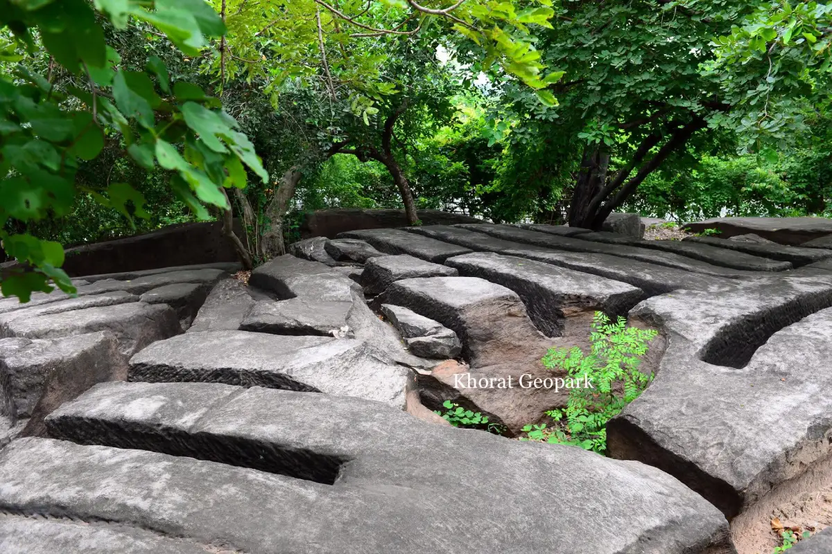
Sikhio Stone Quarry Site, Nakhon Ratchasima Province is an important archaeological site and outdoor geology learning centre beside Mittraphap Road, around kilometre markers 206–207 in Lat Bua Khao Subdistrict, Sikhio District. It lies approximately 40 kilometres from Nakhon Ratchasima city. Its main attraction is not a completed ancient monument or stone sanctuary, but an exposed sandstone surface containing long extraction trenches, rectangular cutting channels, iron-tool marks, and blocks that remain partly separated from the parent rock. These traces reveal the work that took place before sandstone could be used to construct ancient Khmer sanctuaries, a process that required geological knowledge, skilled craftsmanship, organised labour, and a transport system capable of moving massive blocks to religious sites in Sikhio and Sung Noen districts.
The site is known by several names, including Sikhio Stone Quarry Site, Sikhio Stone-Cutting Site, Ancient Stone Quarry Site, and Sikhio Sandstone Quarry Site. All refer to the same archaeological area on a small sandstone hill near Wat Khao Thong Wanaram, also called Wat Phu Khao Thong, opposite the Sikhio branch of the Provincial Waterworks Authority. From the Sikhio interchange, travel west towards Pak Chong for approximately 2.5 kilometres. The entrance lies beside the frontage road, so drivers should slow down and watch for signs well in advance, as Mittraphap Road is a major route used throughout the day by private vehicles, buses, and fast-moving trucks.
The importance of the Sikhio Stone Quarry Site lies in its evidence of an organised production area and raw-material source, rather than merely a place where natural marks happen to appear on rock. Across several sections of the exposed surface, the quarrying channels were laid out systematically. The grooves form straight lines and correspond closely with the sandstone’s natural joint patterns. Ancient quarry workers used these structural weaknesses to reduce the force and time required to detach each block. The site therefore functions like an open-air classroom, explaining the stages through which sandstone passed before becoming building foundations, door frames, columns, walls, lintels, and other architectural elements of stone sanctuaries.
The archaeological site occupies a sandstone hill rising more than 10 metres above Mittraphap Road and reaching approximately 279 metres above mean sea level. Although the hill is not large, its position exposes sandstone outcrops across the area. Some sections are covered by mature trees, dry leaves, and seasonal vegetation. From the car park, visitors will find an information sign, a pavilion for resting, and steps leading to the upper area. The walk is short, but parts of the surface are uneven and include deep channels, natural holes, and rocks at different levels. Visitors should therefore wear secure footwear with good traction.
The bedrock belongs to the Phu Phan Formation of the Khorat Group, part of the extensive sedimentary sequence of the Khorat Plateau. The rock is generally greyish-white sandstone, with pale pink tones in some places. It has a relatively coarse texture and occurs in thick beds. Because it can be cut into blocks and finished to a smoother surface, it was well suited to large-scale construction. The relationship between the properties of the stone and the traces of human activity gives the Sikhio Stone Quarry Site twofold importance: it is both a place for learning about geological landscape formation and evidence of past construction technology.
The Phu Phan Formation sandstone around Sikhio is approximately 130 million years old. It formed from sand and gravel deposited by ancient river systems, then compressed and cemented into solid rock over an immense period. The exposed surface therefore records events separated by very different timescales, from natural processes tens of millions of years ago and changes in waterways and landforms, to human selection, cutting, and transport of stone roughly one thousand years ago. Visitors are not simply looking at ancient quarry trenches; they are standing on a geological record millions of times older than human civilisation.
The northern side of the hill lies close to Mittraphap Road, while Lam Takhong is approximately 1.8 kilometres to the north. Aerial photographs show traces of an ancient watercourse east of the hill that could have connected with Lam Takhong. This setting is significant for understanding the quarry because water sources were essential to ancient communities for consumption, agriculture, and the movement of heavy materials. Although no direct evidence confirms every stage of the stone-transport route, the quarry’s position near waterways and ancient settlements helps reveal a landscape network favourable to the construction of large religious monuments.
Among the clearest visible features are rectangular extraction trenches. These grooves were cut around areas intended to be separated as blocks. Some blocks are square or cube-like, while other areas contain long continuous trenches from which the stone was never removed. Together, these remains demonstrate a sequence of work: determining the required size, opening channels around the block, cutting the sides, and finally separating the base from the original bedrock. Differences among the trenches allow visitors to compare areas where extraction was completed with areas where work stopped midway.
Marks on the sidewalls of the blocks are consistent with the repeated use of iron tools such as chisels. The tool was driven into the stone again and again along a planned line, leaving small, closely spaced marks. Quarry workers had to control both direction and depth with precision, because force applied in the wrong place could crack or deform the block and make it unusable. Stone extraction therefore depended not only on physical labour but also on experience in reading the rock’s texture, fractures, bed thickness, and the direction in which it could be separated safely.
Most quarry trenches correspond with two natural joint directions in the sandstone: northeast to southwest and northwest to southeast. These intersecting lines create shapes resembling rectangles or rounded turtle backs. Ancient workers incorporated this natural structure into their plan because cutting along existing joints reduced the risk of the stone breaking beyond the intended dimensions. A careful look at the site shows that many trenches are not randomly distributed; they were deliberately aligned with the geological structure of the rock.
The choice of block size reflects planning before extraction began. Rectangular blocks were suitable for walls, foundations, and load-bearing architectural components, while square blocks of similar dimensions made it easier for builders to keep courses level. Some blocks may have been cut larger than the final component to allow for surface finishing and reshaping at the construction site. This process shows that work at the quarry had to be closely coordinated with work at the destination, including dimensional standards, the number of blocks required, transport order, and the responsibilities of different groups of craftsmen.
In addition to human-made channels, the rock surface contains natural depressions known in Thai as “kumphalak”, or geological potholes. These are deep holes with broad openings that gradually narrow towards the bottom, relatively smooth inner walls, and pot-like shapes. They form when flowing water traps pebbles in a circular motion at one point for a long period. The rotating gravel slowly abrades the stone, making the hole deeper and wider over hundreds or thousands of years. These potholes confirm that the area was once influenced by flowing water and represent natural evidence that must be distinguished from quarry trenches made by human tools.
Comparing quarry channels with geological potholes is an engaging learning activity for families and students. Human-cut trenches are generally straight, angular, and laid out according to the dimensions of stone blocks. Potholes, by contrast, have curved outlines, rounded walls, and depth produced by swirling water. Observing these differences helps visitors understand how a single rock surface can preserve traces of both nature and culture. A visit should therefore involve more than walking quickly through the site for photographs; it is worth stopping to read the signs, compare shapes, and examine the relationship between each type of mark.
The period when the quarry was used as a production site corresponds with ancient Khmer culture during approximately the 15th–18th Buddhist centuries, or the 9th–13th centuries CE. During this era, communities in the Nakhon Ratchasima region were connected to wider political, religious, artistic, and construction networks. Many sanctuaries used sandstone as a major material because it could be dressed, carved, and assembled into large structures. A raw-material source such as Sikhio was therefore part of the economic and labour system that supported monumental architecture, rather than an isolated area detached from surrounding communities.
Sandstone from this area is associated with major sanctuaries in Sikhio and Sung Noen, including Prasat Mueang Khaek, Prasat Hua Sa, and Prasat Non Ku. This relationship is considered through the sites’ locations, material characteristics, dates, and the scale of the nearby sanctuary network. The quarry helps answer an important question: where did the enormous quantity of stone used in these monuments come from? After visiting the quarry, travellers who continue to the sanctuaries can view the blocks in their walls with a new understanding because they have already seen the beginning of the production process.
Prasat Mueang Khaek is one of the most important ancient Khmer religious sites in Sung Noen District. Its buildings and architectural components required a substantial volume of material. Linking the Sikhio Stone Quarry Site with Prasat Mueang Khaek creates an educational route from raw-material source to finished monument. Visitors can begin at the quarry to examine extraction trenches, then continue to the sanctuary to observe stone masonry, surface finishing, and architectural design. Experiencing the sites in this order makes the archaeological story more tangible than reading about each place separately.
Prasat Non Ku and Prasat Hua Sa form other parts of Sung Noen’s cultural landscape. Although the size and condition of each site differ, together they reflect the distribution of ancient settlements and religious monuments. A nearby source of good-quality stone reduced the burden of long-distance transport, yet still required organised labour and routes capable of moving heavy blocks. Considering these places together demonstrates that an ancient monument was not created solely by craftsmen working at the building site; it depended on networks of people, raw materials, water, food, and management.
Moving blocks away from the production area is one of the most intriguing aspects of the quarry. Large stones were extremely heavy and could not be lifted by a small number of people. The process may have involved wooden levers, ropes, rollers, sledges, draught animals, or dragging along prepared routes. Water transport may have played a role where the terrain allowed, but water levels, seasons, and the distance between quarry and construction site would all have mattered. Although no transport equipment survives directly, the extraction channels and the amount of stone removed indicate labour organisation on a considerable scale.
Before cutting began, quarry workers had to select an area where the bed was thick enough, free from damaging fractures, and suitable for the required dimensions. They then marked or defined the boundaries, opened grooves with iron tools, deepened the channels around the block, and separated its base from the bedrock. After removal, preliminary shaping may have reduced the weight before transport. Fine surface finishing and important carving were generally carried out nearer the construction site, helping to prevent damage in transit and allowing the block to be adjusted to its exact architectural position.
The surviving channels preserve work that ended at several different stages. In some places, only an initial outline is visible. Elsewhere, deep grooves nearly surround a block. Some blocks were detached but remain close to their original positions, while other areas contain only voids left after stone was removed. This variety makes the Sikhio quarry more valuable than a production area worked so completely that no evidence remained, because researchers can see multiple stages on the same surface. Preserving these traces is therefore essential for future study of ancient quarrying methods.
The visitor area can be understood as a sequence beginning at the entrance and car park, followed by the information sign, rest pavilion, steps up the hill, the rock platform containing quarry trenches, and the geological pothole area. Visitors should first spend time reading the sign to understand the overall context before examining the evidence itself. On reaching the rock platform, follow safe routes and look for rectangular grooves in the ground. Some are covered by leaves or have colours similar to the surrounding rock. Viewing them from several angles helps reveal their depth and cutting direction more clearly.
The car park is the starting point for preparing equipment and checking readiness. It is suitable for private vehicles and short visits, but spaces may be limited when school groups or study tours arrive at the same time. Vehicles should be parked neatly without blocking access, and never on the shoulder of Mittraphap Road. The pavilion is a useful place to rest before or after climbing the hill, particularly for older visitors, children, and anyone arriving during hot weather.
Interpretive signs are important because quarry marks can resemble natural features to visitors who have never seen an ancient stone-production site. Reading the information before exploring helps identify what to look for, including rectangular forms, chisel marks, natural joints, and potholes. When several groups are present, visitors should avoid standing in front of a sign for too long. Stickers, writing, or marks should never be placed on the panels, as these interpretive materials are part of the site’s educational infrastructure.
The staircase makes the upper area easier to reach than climbing directly across the rock face, but dry leaves, loose sand, and wet surfaces during the rainy season still require caution. Older visitors should use the handrail or walk with assistance. Wheelchair users can access the car park, pavilion, and lower information area, but the steps and uneven upper rock surface mean the complete route is not wheelchair-accessible. Families with young children should supervise them closely at all times and should not allow them to run across the rock platform.
The quarry-trench platform is the central feature of the visit. Walk slowly around the edges and avoid stepping across deep gaps unnecessarily. Some channels are wide enough to trap a foot or cause a loss of balance, and fallen leaves may make their depth difficult to judge. Standing slightly back and viewing from an angle reveals the block shapes and trench walls more clearly than straddling the grooves. Visitors should not sit, stand, or place belongings inside the channels, both for safety and to prevent surface damage.
The pothole area requires the same level of care. Some depressions have broad openings and smooth walls; when filled with rainwater, their depth can be difficult to see. Visitors should not climb into them for photographs or try to rotate stones inside, as doing so creates a slipping hazard and disturbs the natural condition of the evidence. Parents can explain to children that these holes were not drilled by quarry workers but formed through the prolonged action of water and gravel. Learning to distinguish natural marks from human-made ones is one of the site’s most valuable experiences.
The morning period between 08.00 and 10.00 is one of the best times to visit. Temperatures are still moderate, angled sunlight casts shadows into the extraction channels and makes their depth easier to see, and visitor numbers are usually low. The period after 15.00 also offers a quieter atmosphere and softer light, but visitors should begin exploring before 16.00 to allow enough time to descend and leave before closing. Midday visits are possible, although the rock surface absorbs heat and shaded areas are unevenly distributed.
The cool season from November to February is particularly suitable for outdoor exploration. Morning temperatures are comfortable, and the rock surface may be easier to see when vegetation is less dense. From March to May, visitors should bring a hat, drinking water, and sunscreen. Trees provide some shade, but heat radiating from the stone can make conditions feel hotter. During the rainy season, the surroundings become greener and the air fresher, but steps and rock surfaces may be slippery. Check the weather and avoid climbing the hill during heavy rain or storms.
Suitable footwear includes closed shoes or sports shoes with treaded soles. High heels, smooth-soled sandals, and loose shoes that can slip off easily should be avoided. Clothing should be breathable and allow comfortable movement. Visitors sensitive to insects may wish to bring repellent, as the area contains trees, leaf litter, and natural vegetation. Bags should be compact so that they do not strike rocks or branches while walking. Heavy hiking equipment is unnecessary because the uphill distance is short, but caution is more important than speed.
A typical visit takes approximately 45–90 minutes. Visitors who want only to see the principal features and take photographs may spend around 45 minutes, while those interested in archaeology, geology, or detailed photography should allow at least 1.5 hours. Walking through too quickly can mean missing small chisel marks, blocks that were never lifted, and differences among individual work areas. Before leaving, check all belongings and take every piece of rubbish away, as this natural site does not provide extensive services like a park or museum.
Photography should emphasise angles that show the shape of the trenches and the relationship between extraction marks and the surrounding rock. Side lighting in the morning or afternoon creates shadows that reveal detail better than direct midday light. A wide-angle lens is useful for overall views of the platform, while a standard lens or smartphone can record chisel marks and surface texture effectively. Do not place tripods across walking routes or insert equipment into the grooves. Drone photography requires permission from the responsible authority and must comply strictly with aviation regulations.
Chalk, water, paint, or any other material should never be applied to the grooves to make them appear more clearly in photographs. Although this might temporarily emphasise the lines, it can leave stains, alter the surface, and mislead later visitors. Rubbing, scraping, or testing the rock with a striking tool must be strictly avoided because the ancient tool marks are valuable precisely in their original condition. Taking fragments of stone as souvenirs is also inappropriate, even when the pieces are small, because every element forms part of the archaeological and geological context.
The Fine Arts Department is the principal authority responsible for the Sikhio Stone Quarry Site, with local work carried out under the 10th Regional Office of Fine Arts, Nakhon Ratchasima. Maintenance includes clearing vegetation, cleaning around the site, inspecting paths, and keeping the quarry marks visible. The most recent recorded operation, dated 14 January 2026, states that Narong Chinnuhaen, an ancient-monument maintenance worker, and a team of officials cleared and cleaned the area. Continued care prevents roots, leaves, and weeds from obscuring or disturbing the evidence on the rock surface.
Although the archaeological database states that the site has not yet been formally registered as an ancient monument, this does not mean that anyone may excavate, cut, move, or alter it. The area is supervised by the Fine Arts Department and is valuable as an archaeological production site and raw-material source. Visitors should behave as they would in an open-air museum: do not climb over barriers, enter closed areas, touch or move stones, and report vandalism, graffiti, or unusual activity to the responsible authority.
Confirmed facilities at the site include a car park, interpretive panels, a rest pavilion, and steps leading up and down the hill. These features were installed to make the archaeological site more accessible to the public. This is not a large tourism centre, so visitors should not expect restaurants, drink shops, or permanently available guide services inside the grounds. Use a toilet, refill drinking water, and purchase snacks at a petrol station, local shop, or in central Sikhio before visiting.
School groups and educational tours should contact the 10th Regional Office of Fine Arts, Nakhon Ratchasima, in advance, especially when requesting a speaker, academic information, or access for a large group. Providing the number of participants and a clear schedule allows officials to assess parking, safety, and the order of activities. Students should be divided into smaller groups to avoid crowding on the extraction trenches, while supervisors should closely monitor areas containing holes or uneven surfaces.
Outdoor learning at the site can connect several subjects. History explains ancient Khmer cultural networks and the construction of religious monuments. Geology covers rock types, sediment deposition, joint patterns, and potholes. Engineering raises questions about tools, load-bearing structures, and transport, while environmental studies can examine conservation challenges at an outdoor site exposed to rain, sunlight, roots, and human activity. The quarry is therefore especially suitable for developing observation and inquiry rather than merely memorising facts.
Families can use the visit to show children that stone sanctuaries did not appear fully formed. Their construction began with selecting a rock bed, cutting blocks, moving them, finishing their surfaces, and assembling them into buildings. Children can count block shapes, compare wide and narrow trenches, or look for areas where chisel marks remain visible, provided parents set clear boundaries against touching the stone or climbing into holes. Learning from visible evidence makes the labour and knowledge of past communities easier to understand than seeing only a photograph of a completed sanctuary.
Older visitors who can walk independently may reach the upper area at an unhurried pace. Resting at the pavilion before climbing and avoiding the hottest midday period are advisable. Anyone with knee problems, balance difficulties, or heart disease should consider viewing the lower information area and asking companions to bring back detailed photographs. Forcing a climb when physically unprepared adds unnecessary risk. Companions should carry drinking water, essential medication, and a sufficiently charged telephone.
Solo travellers should tell someone where they are going and avoid overgrown or off-route areas. Although the site is close to a major road, parts of the hill can be quiet, particularly on weekdays. Visiting during opening hours, carrying a telephone, and parking in the designated area reduce risk. Valuables should not be left visible inside a vehicle. If broken branches, venomous animals, or unsafe path conditions are encountered, turn back and inform the responsible authority rather than continuing.
The Sikhio Stone Quarry Site is open daily from 08.00 to 17.00 and admission is free. Free access allows residents, students, and travellers to encounter archaeological heritage easily, but every visitor also contributes to its protection by keeping the area clean, avoiding damage, and sharing accurate information. Reviews and social-media posts should use the correct site name and location and should mention appropriate visitor conduct, helping future travellers understand its value as more than a roadside photography stop.
Getting There from Nakhon Ratchasima city, take Mittraphap Road or Highway 2 towards Sung Noen, Sikhio, and Pak Chong for approximately 40 kilometres. After passing Sung Noen and approaching the Sikhio interchange, prepare to enter the frontage road following signs towards Pak Chong. The quarry lies near kilometre markers 206–207 beside Wat Khao Thong Wanaram, or Wat Phu Khao Thong, opposite the Sikhio branch of the Provincial Waterworks Authority. Open navigation before reaching the area and reduce speed in advance to avoid missing the entrance.
Travellers from Bangkok should take Highway 1 to Saraburi, then join Mittraphap Road through Muak Lek, Pak Chong, Lam Takhong Dam, and Sikhio. After passing the dam and heading towards Nakhon Ratchasima, look for Wat Khao Thong Wanaram and the waterworks office. Depending on the direction of travel, access may require using the frontage road or a designated U-turn. Drivers should never change lanes abruptly because this section carries many trucks and traffic speeds vary considerably between lanes.
The reference coordinates are 14.85672, 101.67604. Using coordinates reduces confusion caused by the site’s several names. In map applications, search for “แหล่งหินตัดสีคิ้ว” or “Sikhio Stone Quarry Site”. Check the route again before departure because navigation systems may select an entrance on the opposite side of Mittraphap Road. Entering the frontage road at the correct point is safer than stopping or reversing after passing the entrance.
Public transport is possible on routes serving Sikhio District or Mittraphap Road. From a stop in central Sikhio, continue by hired car, motorcycle taxi, or a prearranged vehicle. Walking along the shoulder of Mittraphap Road from a distant stop is unsafe because traffic moves quickly and some sections lack a protected footpath. Arrange a return pickup in advance, as there is no permanent taxi rank at the quarry.
Rail travellers can disembark at Sikhio Railway Station and continue by hired vehicle. The distance is short by road but unsuitable for walking along the highway. Those staying in town can ask their accommodation to call a vehicle or organise a transfer. Renting a car or travelling by private vehicle remains the most convenient choice because it allows the quarry to be combined in one day with Sap Pradu Reservoir, Lam Takhong Dam, Khao Yai Thiang, and other cultural attractions.
A practical half-day itinerary begins at the quarry in the morning, allowing approximately 1 hour, followed by Sap Pradu Reservoir for scenery, rest, and a meal before returning to central Sikhio. This route suits travellers with limited time who do not want to drive into mountainous terrain. Families travelling with children or older people should schedule adequate rest and avoid adding so many stops that the day becomes rushed.
A full-day itinerary can begin at the quarry, continue to the Somdet Phra Phutthachan To Great Vihara Merit Park, include lunch along Mittraphap Road, and finish in the afternoon at the upper reservoir and wind turbines of Khao Yai Thiang. This route combines history, religion, engineering, and natural scenery. Drivers should allow extra time for steep roads and check their brakes before ascending Khao Yai Thiang. Descend before dark to avoid reduced visibility.
Travellers with a strong interest in archaeology can plan a route from the quarry to Prasat Mueang Khaek, Prasat Non Ku, and Prasat Hua Sa in Sung Noen District. Beginning at the raw-material source reveals the trenches and block sizes before visitors see how sandstone was used in actual sanctuaries. Allow enough time at each place to read the signs and examine the materials. The purpose is not simply to accumulate the greatest number of stops, but to connect production, transport, and construction into one coherent story.
Wat Khao Thong Wanaram, also called Wat Phu Khao Thong, adjoins the quarry area and is an important landmark for navigation. Visitors may stop to pay respect and rest in a quiet atmosphere, but should dress modestly, keep noise low, and avoid disturbing monks or community activities. The temple and quarry serve different functions, so follow the signs in each area. Do not use the temple grounds for parking without permission when the quarry car park remains available.
Sap Pradu Reservoir lies a short distance from central Sikhio and provides a relaxing change from the rock platform and archaeological story to a waterside landscape. Viewpoints, restaurants, and several recreation areas surround the reservoir. Water levels and scenery change with the seasons. Visitors should take care on sloping banks, dispose of rubbish responsibly, and avoid swimming in areas without designated safety provisions. Combining the quarry and Sap Pradu Reservoir in one day is suitable for families and travellers seeking light activities.
Lam Takhong Dam is a major landmark on the route between Pak Chong and Sikhio. Rest areas and viewpoints overlook a broad expanse of water, mountain ridges, and the dam structure. Travellers can stop before or after the quarry according to their direction of travel. Light near sunset is attractive, although holiday traffic may be heavy. Vehicles should stop only in designated parking areas, and pedestrians should use marked bridges or walking routes.
Khao Yai Thiang and the upper reservoir of the Lam Takhong power plant suit visitors who want scenic views and an introduction to pumped-storage hydropower. The area includes cycling routes, wind-turbine viewpoints, and elevated views across Lam Takhong Reservoir. The mountain road has bends and steep gradients, so drivers must select appropriate gears and avoid excessive speed. Cyclists should follow site regulations. Pairing Khao Yai Thiang with the quarry links the historical use of natural resources with a contemporary energy system.
Nearby restaurants are distributed across central Sikhio, along Mittraphap Road, and around Lam Takhong Reservoir. Travellers seeking local food can choose Krua Pa Mon, while those wanting suki can visit Nuch Suki Sikhio. Wagyu Korat serves beef and steak dishes connected with local producers. Lam Takhong Cafe is suitable for coffee and meals in a shaded setting, while Na Korat Plateau offers a contemporary dining atmosphere. Telephone ahead to confirm opening days and kitchen closing times.
Accommodation choice depends on the travel plan. Green Place Sikhio and The River Apartment suit visitors who want to stay near the market, shops, and services in central Sikhio. Those preferring a resort atmosphere can consider Mountain Creek Golf Resort & Residences or Fa Plai Rung Resort, while Ban Yai Resort is an option farther from the town centre. Room rates and services vary by travel date, so book directly and confirm the exact location before payment.
An overnight stay makes the itinerary less rushed. On the first day, visitors can explore the quarry, the sanctuaries in Sung Noen, and Sap Pradu Reservoir. The second day can be devoted to Lam Takhong Dam, Khao Yai Thiang, or Pak Chong. This approach reduces prolonged evening driving and makes it easier to choose suitable light for photography. Travellers from Bangkok can use Sikhio as an overnight stop before continuing to Nakhon Ratchasima, while those arriving from northeastern Thailand can pause here before travelling towards Pak Chong and Saraburi.
The Sikhio Stone Quarry Site has no light-and-sound show, souvenir shop, or large-scale entertainment. Its appeal lies in observing authentic evidence in an outdoor setting. Visitors expecting only a major photography attraction may spend little time, but those who read the background and know how to examine the extraction marks will find many details. The quiet surroundings make it easier to imagine the rhythm of chisels, cooperation among workers, and the movement of stone blocks away from the hill hundreds of years ago.
Another major value of the site is the relationship it reveals between natural resources and culture. Sandstone formed through natural sedimentary processes, but once people understood its properties, it became part of religion, art, architecture, and social power. Selecting the source, organising labour, and constructing buildings required knowledge across many fields. The quarry therefore reminds visitors that cultural heritage includes not only objects made by humans, but also the landscapes and resources that made creation possible.
Conserving an outdoor site presents challenges different from preserving objects inside a museum. Rain wets and erodes the stone, sunlight causes temperature changes, roots penetrate fractures, leaves retain moisture, and trampling or graffiti causes direct damage. Vegetation must therefore be cleared carefully so that tools do not strike the rock surface. Maintaining paths and signs is equally important because they guide visitor movement and reduce entry into fragile areas.
The local community contributes to protection by watching over the site, maintaining cleanliness, and passing knowledge to visitors. Shops, accommodation providers, and transport services also support the surrounding economy. When tourism is responsible, income can circulate locally without turning an archaeological area into an entertainment venue. Using local services, buying food in the district, and respecting regulations help balance economic benefit with conservation.
Information about the quarry should be presented carefully, separating facts visible in the evidence from unsupported stories. Extraction trenches and chisel marks can be observed directly. Connections between the sandstone and individual sanctuaries are archaeological interpretations based on material, distance, and date. Stories about treasure, tunnels, or rituals should not be invented without evidence, as they obscure the site’s genuine value as a record of technology and labour.
Visitors should check traffic conditions on Mittraphap Road before departure, particularly during New Year, Songkran, long weekends, and Sunday evenings. Congestion can develop around Pak Chong, Lam Takhong Dam, and the Sikhio interchange. Refuel, check tyre pressure, and prepare drinking water before reaching the area. Allowing extra travel time avoids rushing near closing time and reduces the temptation to change lanes suddenly.
Before leaving the site, make sure all belongings have been collected and take bottles, food packaging, and paper to an appropriate disposal point. Coins, flowers, incense, or offerings should not be placed in the potholes because this is an archaeological and geological site, not a ritual location. Preserving the original condition keeps the evidence readable for future researchers, students, and travellers.
The Sikhio Stone Quarry Site completes the story of Nakhon Ratchasima’s stone sanctuaries. People usually encounter only the finished buildings, but this place reveals the first stages of construction, from selecting a suitable bed and determining block dimensions to using chisels along natural joints and preparing stone for transport. Every groove functions like a record of unnamed workers whose knowledge and skill remain clearly inscribed on the rock surface.
The most rewarding visit gives time to detail: walk carefully, read the signs, compare human-cut channels with natural potholes, and relate the evidence to the landscape around Lam Takhong. When continuing to Prasat Mueang Khaek, Prasat Non Ku, or other religious sites, visitors will better understand the complex process each block passed through before becoming part of the architecture. The Sikhio Stone Quarry Site is therefore more than a stop beside Mittraphap Road; it is a tangible gateway to the technology, resources, and social organisation of people in the past.
| Name | Sikhio Stone Quarry Site |
| Alternative Names | Sikhio Stone-Cutting Site, Ancient Stone Quarry Site, and Sikhio Sandstone Quarry Site |
| Site Type | Archaeological production and raw-material site, as well as an outdoor geology learning site |
| Location | Mittraphap Road, Highway 2, kilometre markers 206–207, Lat Bua Khao Subdistrict, Sikhio District, Nakhon Ratchasima Province 30140 |
| Landmarks | Beside Wat Khao Thong Wanaram, also called Wat Phu Khao Thong, opposite the Sikhio branch of the Provincial Waterworks Authority, approximately 2.5 km towards Pak Chong from the Sikhio interchange |
| Coordinates | 14.85672, 101.67604 |
| Distance From Nakhon Ratchasima City | Approximately 40 km |
| Highlights | Rectangular sandstone extraction trenches, iron-tool marks, partly quarried blocks, natural joint patterns, and geological potholes on the rock surface |
| Archaeological Period | 15th–18th Buddhist centuries, approximately the 9th–13th centuries CE |
| Historical Period and Culture | Historic period associated with ancient Khmer culture |
| Geological Characteristics | A sandstone hill in the Phu Phan Formation of the Khorat Group; the sandstone is approximately 130 million years old |
| Related Ancient Monuments | Prasat Mueang Khaek, Prasat Hua Sa, Prasat Non Ku, and other ancient Khmer religious sites in Sikhio and Sung Noen |
| Main Areas and Zones | 1. Car park and entrance 2. Interpretive information panels 3. Rest pavilion 4. Staircase and path up the hill 5. Sandstone extraction-trench platform 6. Partly quarried stone-block area 7. Geological pothole and natural-evidence area |
| Facilities | Car park, interpretive panels, rest pavilion, and steps leading up and down the sandstone hill |
| Accessibility Limitations | The upper area has steps, deep trenches, and uneven rock surfaces, so the entire route is not wheelchair-accessible |
| Open Days | Daily |
| Opening Hours | 08.00 – 17.00 |
| Admission Fee | Free admission |
| Recommended Visiting Time | 08.00–10.00 or 15.00–16.30 |
| Suggested Visit Duration | Approximately 45–90 minutes |
| Responsible Authority | Fine Arts Department through the 10th Regional Office of Fine Arts, Nakhon Ratchasima. The most recent recorded site maintenance on 14 January 2026 was carried out by Narong Chinnuhaen, an ancient-monument maintenance worker, and a team of officials. |
| Responsible Authority Contact | 10th Regional Office of Fine Arts, Nakhon Ratchasima: 044-471518 and 044-481024 |
| Travel Information | From Nakhon Ratchasima city, take Mittraphap Road towards Sikhio and Pak Chong. After passing the Sikhio interchange, enter the frontage road and continue for approximately 2.5 km. Look for Wat Khao Thong Wanaram and the Provincial Waterworks Authority office. |
| Current Status | Open to visitors and maintained through regular cleaning and vegetation clearance |
| Nearby Tourist Attractions | 1. Wat Khao Thong Wanaram or Wat Phu Khao Thong, approximately 1 km 2. Sap Pradu Reservoir, approximately 7 km 3. Somdet Phra Phutthachan To Great Vihara Merit Park, approximately 13 km 4. Lam Takhong Dam and viewpoint, approximately 15 km 5. Khao Yai Thiang upper reservoir and wind turbines, approximately 22 km 6. Wat Loet Sawat and Khao Chan Ngam prehistoric rock paintings, approximately 25 km |
| Nearby Restaurants | 1. Krua Pa Mon Sikhio, approximately 4 km, Tel. 086-876-2977 2. Nuch Suki Sikhio, approximately 13 km, Tel. 081-389-4300 3. Wagyu Korat, approximately 13 km, Tel. 084-246-9523 4. Lam Takhong Cafe & Resort, approximately 18 km, Tel. 065-878-5992 5. Na Korat Plateau, approximately 20 km, Tel. 084-364-9336 and 098-164-1417 |
| Nearby Accommodations | 1. Green Place Sikhio, approximately 5 km, Tel. 086-256-9988 2. The River Apartment, approximately 6 km, Tel. 088-581-6607 3. Mountain Creek Golf Resort & Residences, approximately 8 km, Tel. 088-885-3782, 094-889-8869, and 044-756100-5 4. Fa Plai Rung Resort, approximately 9 km, Tel. 088-377-9989 5. Ban Yai Resort Sikhio, approximately 15 km, Tel. 093-324-2922 |
Frequently Asked Questions (FAQ)
Q: Where is the Sikhio Stone Quarry Site?
A: It is beside Mittraphap Road, or Highway 2, around kilometre markers 206–207 in Lat Bua Khao Subdistrict, Sikhio District, Nakhon Ratchasima Province. The site is next to Wat Khao Thong Wanaram and opposite the Sikhio branch of the Provincial Waterworks Authority.
Q: What are the opening hours, and is admission free?
A: The site is open daily from 08.00 to 17.00, and admission is free.
Q: Why is the Sikhio Stone Quarry Site important?
A: It is an ancient sandstone raw-material and production site preserving evidence of iron tools used to cut blocks for religious construction associated with ancient Khmer culture in Sikhio and Sung Noen.
Q: What created the grooves on the rock surface?
A: Straight and rectangular grooves were cut by ancient quarry workers. Some broad, rounded holes are geological potholes formed when swirling water and gravel eroded the sandstone over a long period.
Q: How much time should visitors allow?
A: Allow approximately 45–90 minutes to read the signs, examine chisel marks, compare extraction trenches, and photograph the details properly.
Q: Can older visitors and wheelchair users access the site?
A: The car park, pavilion, and lower information area are relatively accessible, but the upper quarry platform has steps, uneven rock, and deep channels. The complete route is therefore not wheelchair-accessible.
Q: What should visitors bring?
A: Wear secure closed shoes with good traction and bring drinking water, a hat, sunscreen, and insect repellent. Avoid high heels and smooth-soled sandals.
Q: Which attractions can be combined with the quarry?
A: The site can be included in an itinerary with Sap Pradu Reservoir, Lam Takhong Dam, Khao Yai Thiang, the Somdet Phra Phutthachan To Great Vihara Merit Park, Prasat Mueang Khaek, Prasat Non Ku, and Prasat Hua Sa.
 Category: ●Art, Culture and Heritage
 Group: ●Historical Sites and Monuments
Last Update : 3 MonthAgo
 Last Update : 3 MonthAgo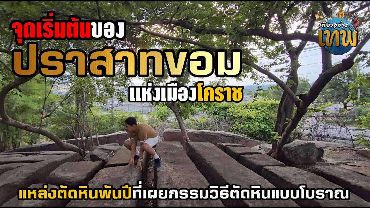
 Click to Access the Navigation Map GPS
Sikhio Stone Quarry Site Map
Recommend
 Historical Sites and Monuments(20)
 Landmarks and Memorials(5)
 Art, Craft Centres, Tradition(7)
 Museums(6)
 Art Gallery(1)
 Educational Places
 Educational Gardens, Farm(4)
 Places of Worship
 Temple(29)
 Mosque(1)
 Other Sacred Sites(6)
 Research and Development
 Royal Project(3)
 Suburban Living
 Village, Community(6)
 Local Market(4)
 Floating Market(1)
 Nature and Wildlife
 National Parks and Marine Reserves(3)
 Mountain (Doi)(5)
 Dam, Reservoir, Lake(8)
 Waterfalls(9)
 Hot Springs(1)
 Caves(2)
 Flower Field(1)
 River, Canal(8)
 Bays and Beaches(2)
 Other natural attractions(3)
 Entertainment and Agricultural
 Zoos and Aquariums(2)
 Animal camps and shows(1)
 Farms, Parks and Ecotourism(21)
 Waterpark(4)
 Outdoor and Adventure Activities(6)
 Shopping
 Shopping and Night Market(2)
 Travel Articles, Recipes
 Travel Review, Food Review(6)


