
lovethailand home >Northeastern Travel Attractions >Nakhon Ratchasima Travel Attractions >Phi Mai >Nai Muang > Phimai Historical Park
TL;DR: Phimai Historical Park is located at Nai Mueang Subdistrict, Phimai District, Nakhon Ratchasima Province, open Daily, with no regular weekly closing day, hours 07:30 – 17:30.
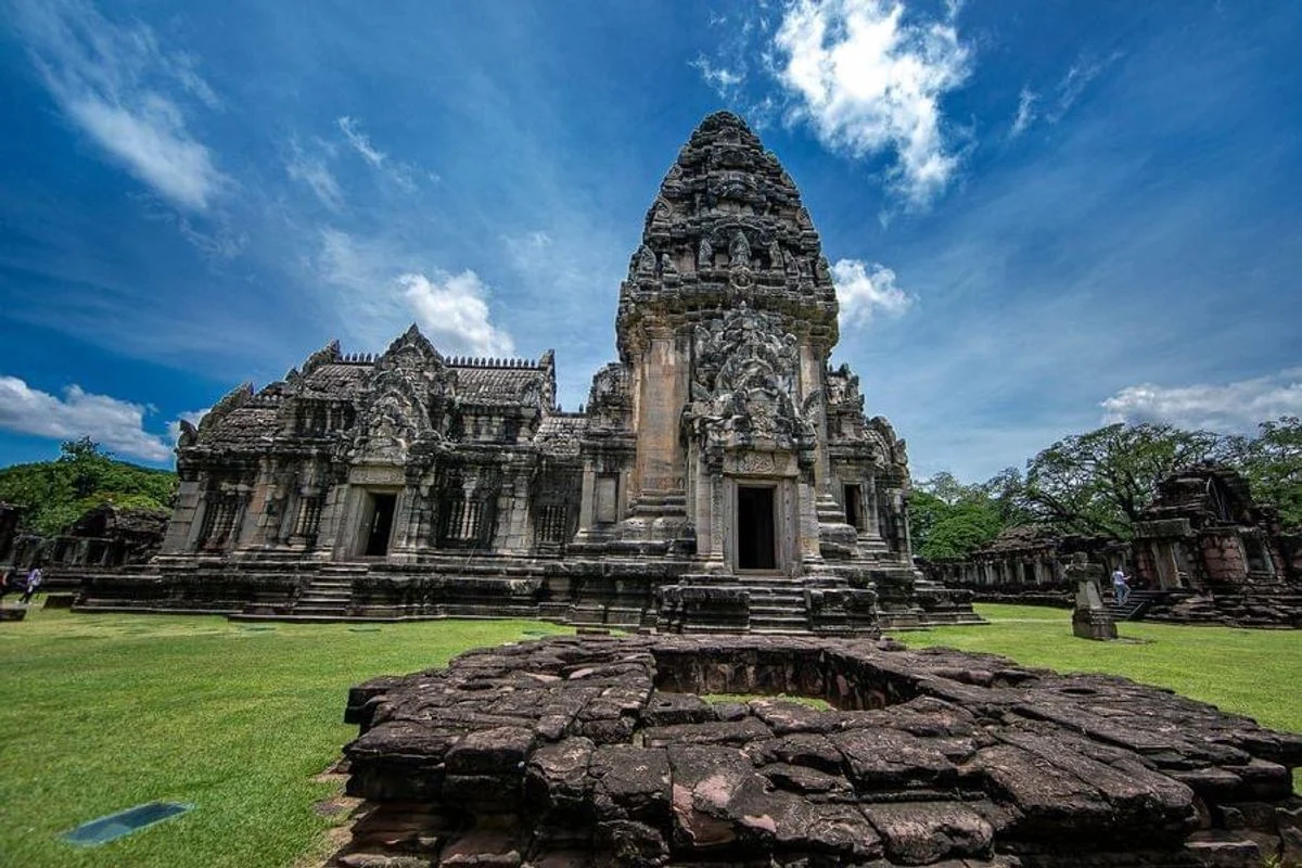
Phimai Historical Park
Open Days: Daily, with no regular weekly closing day
Opening Hours: 07:30 – 17:30
Phimai Historical Park in Nakhon Ratchasima Province is one of Thailand’s most important archaeological landscapes and one of the finest surviving centers of ancient Khmer architecture in the country. Its principal monument, Prasat Hin Phimai, stands in the center of modern Phimai town within an ancient urban plan that still preserves city gates, defensive walls, moats, water systems, religious buildings, and archaeological sites beyond the main sanctuary. Phimai is distinguished by its monumental sandstone architecture, Buddhist imagery, architectural sculpture reflecting both Mahayana Buddhism and Brahmanical traditions, and an unusual south-facing ceremonial axis connected to the ancient road toward Angkor. The park is open daily from 07:30 to 17:30. Admission is THB 20 for Thai visitors and THB 200 for foreign visitors. Children, students, senior citizens, and Buddhist monks receive free admission under the park’s conditions. Travelers should allow approximately 2–3 hours for the main sanctuary and visit in the morning or late afternoon to avoid the strongest heat.
The area managed as Phimai Historical Park is considerably larger than the ticketed sanctuary compound. The Fine Arts Department is responsible for approximately 2,658 rai covering the major archaeological components of the ancient city. The northern and eastern boundaries relate to the Mun River, the western side to the Chakkarat watercourse, and the southern area extends toward the ancient baray. The central sanctuary visited by most travelers occupies approximately 115 rai. The ancient urban enclosure formed a rectangle approximately 565 m wide and 1,030 m long, surrounded by walls and moats. Understanding this distinction is essential: Phimai was not simply a large temple standing alone, but an urban center with residential communities, transportation routes, water management, religious institutions, and public infrastructure arranged around the sacred core.
Geography played a central role in the development of Phimai. The town occupies fertile lowland supplied by the Mun River, the Chakkarat River, and associated waterways. These conditions supported permanent settlement, rice cultivation, animal husbandry, water transport, and regional trade. The Mun River passes along the north and east, while the Chakkarat waterway lies toward the west and smaller watercourses and reservoirs extend southward. This position connected settlements throughout the Mun River basin with the interior of the Khorat Plateau and with routes crossing the Dongrek Mountains toward Angkor. The combination of a monumental sanctuary, city gates, a baray, an Arokayasala hospital chapel, and extensive surrounding settlement demonstrates that Phimai functioned as a regional center rather than a small village that happened to possess an isolated temple.
The name Phimai is associated with the ancient Khmer terms Vimaya and Vimayapura. Khmer inscriptions appear on the doorway of the inner gallery and at several related sites. One inscription refers to Kamrateng Jagat Vimaya and records an important sacred image known as Kamrateng Jagat Senapati Trailokyavijaya, together with information connected to the year 1108 CE. Vimaya may originally have been the name of a sacred image, sanctuary, or holy city. Through changes in pronunciation and writing, the ancient term developed into the modern Thai name Phimai. The inscriptions confirm that the city possessed an established religious administration responsible for images, offerings, property, and personnel and that it occupied an important position within the political and religious networks of the ancient Khmer world.
Prasat Hin Phimai was developed over several centuries, broadly from the 11th to the 13th century CE. Architectural and sculptural elements belong to the Baphuon, Angkor Wat, and Bayon periods, demonstrating that the complex was not completed during a single reign. The earliest major phases are associated with the period of King Suryavarman I, while later additions and modifications continued through changing political and religious circumstances. Prang Brahmadat, sections of the city gates, and the Arokayasala south of the city relate strongly to the reign of King Jayavarman VII. The sanctuary should therefore be read as a stone record of several historical phases rather than as a building representing one fixed moment in time.
Although Phimai employs the architectural vocabulary and engineering traditions of ancient Khmer culture, its principal religious identity is associated with Mahayana Buddhism. This differs from many Khmer sanctuaries founded primarily as Brahmanical temples. Images of the Buddha protected by the naga, bodhisattvas, and Buddhist sacred figures appear beside deities, guardians, and narratives derived from Hindu epics. This combination was not necessarily contradictory. Ancient Khmer religious culture could incorporate deities and protective symbols from different traditions within a Buddhist sacred framework. The central tower represented the most sacred cosmic center, while the galleries, walls, gates, naga bridge, and secondary buildings created a sequence leading from the human world toward the realm of enlightenment and divine power.
The most unusual feature of Prasat Hin Phimai is its principal southern orientation. Many Khmer sanctuaries place their main approach toward the east, but Phimai faces the route leading south from the town toward Angkor. Ancient travelers approaching from that direction entered through Pratu Chai, the Victory Gate, and could see the temple centered within the gateway. The same axis continued through the naga bridge, southern gopura, inner gallery, and central tower. This careful alignment integrated urban planning with sacred architecture. It also transformed the arrival at Phimai into a ceremonial progression in which travelers moved step by step from the road, through the fortified city, and toward the religious heart of the region.
Before reaching the naga bridge, visitors pass the structure traditionally called the Robing Pavilion or Treasury. The sandstone building may have provided a place where a ruler or ceremonial party rested, changed clothing, prepared offerings, or stored valuables before entering the sanctuary. Its exact ancient function cannot be established in every detail, but its position outside the main ceremonial bridge shows that preparation occurred before entry into the sacred enclosure. The foundations, doorways, and column positions demonstrate that the approach to the temple contained buildings with supporting functions and was not simply an empty foreground before the monumental tower.
The Naga Bridge is the first element to create an unmistakable transition into sacred space. It stands before the southern gateway in a cruciform plan and rises approximately 2.50 m above the surrounding ground. Its balustrades take the form of serpentine naga bodies ending in 7 hooded heads facing the stairways in the 4 directions. Lion sculptures stand nearby as protective guardians. The bridge did not cross an ordinary river. It represented a symbolic passage between the human world and the divine or enlightened realm. The image of the naga is meaningful in both Buddhist and Brahmanical cosmology, and climbing the bridge marked the visitor’s movement from the everyday landscape into the ordered universe of the sanctuary.
Beyond the bridge stands the southern gopura of the outer enclosure. Constructed from sandstone, the gateway has a cruciform plan with chambers, projecting porches, and a central passage. Similar gopuras stand to the north, east, and west. The connecting outer wall forms a rectangle approximately 277.50 m from north to south and 220 m from east to west. These gateways controlled access and marked the boundary of the temple, but they also created spaces where processions paused, guards or attendants worked, and ritual movement was organized. Looking back toward the naga bridge from the southern gopura clearly reveals the deliberate sequence of the ceremonial axis.
The western gateway preserves an important carved lintel depicting a procession carrying an image of the Buddha seated beneath a naga. The scene provides direct evidence of the Mahayana Buddhist character of Phimai and may preserve aspects of real ceremonies involving the movement of sacred images. Figures carrying the beam, attendants, ritual objects, and the protected Buddha reveal information about religious performance, clothing, and social organization. Other lintels and pediments throughout the complex illustrate episodes from Buddhist texts, the Ramayana, the Mahabharata, and Tantric traditions. Visitors should therefore examine the sculpture as a visual religious language rather than viewing it only as ornamental stonework.
Past the outer courtyard stands the inner enclosure, constructed as a roofed gallery surrounding the central sanctuary. The gallery forms a rectangle approximately 80 m from north to south and 72 m from east to west. Its passage is around 2.35 m wide and originally continued beneath stone roofing around all 4 sides. The enclosed corridor created an atmosphere distinct from the bright exterior courtyard and may have supported circumambulation, ritual preparation, controlled access, or resting areas for participants. Doorways align with the principal and secondary axes, creating framed views of the central tower. Walking through the long passage demonstrates how ancient architects controlled light, movement, and visual focus.
Restoration of the gallery in 1989 revealed repoussé gold sheets decorated with 8-petalled lotus designs. They had been deposited in prepared cavities beneath the stone floor near several gateways. Such concealed deposits were associated with foundation and consecration ceremonies. The lotus symbolized purity, sacred birth, and cosmic order in Buddhist thought. Their discovery demonstrates that religious meaning was embedded not only in visible architecture but also within hidden construction layers. The floor on which visitors walk therefore covers ritual deposits that transformed the structure into sacred ground from the moment of its foundation.
The central sanctuary stands in the middle of the inner courtyard and forms the supreme architectural and religious focus of the complex. It is constructed primarily from durable pale sandstone, contrasting with the red sandstone used for many walls and gateways. The tower rises approximately 28 m. Its square base, about 22 m on each side, incorporates 12 recessed corners that create a vertical rhythm leading toward the summit. The ascending form represented Mount Meru, the cosmic mountain at the center of the universe in Indian religious thought. Placing the tower within successive galleries and walls reinforced the idea that worshippers moved through concentric cosmic realms before reaching the sacred center.
A mandapa stands in front of the central tower and is connected to it by an antarala or narrow vestibule. The tower, connecting chamber, and mandapa rest on a shared platform. Porches and stairways extend on the northern, eastern, and western sides, allowing access from 4 directions even though the primary ceremonial approach to the entire complex remains in the south. The inner chamber once contained an important sacred image. Doorways, lintels, and pediments present Buddhist and Indian narrative imagery. Examining the mandapa, vestibule, and sanctuary separately reveals that the building is a sequence of spaces with different ritual functions rather than a single undivided mass.
The carved lintels and pediments of the central sanctuary deserve careful attention. Images of the Buddha meditating beneath the protective hood of the naga express spiritual authority and divine protection. Other carvings depict deities, guardians, mythical animals, and episodes from the Ramayana and Mahabharata. Crowns, jewelry, gestures, weapons, and floral patterns help scholars identify artistic periods and religious meanings. The sculpture did more than beautify the building; it communicated doctrine, royal power, protection, and the sacred character of each entrance. The position of a narrative above a particular doorway may have influenced how worshippers understood the direction and ritual importance of that side.
Prang Brahmadat stands in front of and slightly to the left of the central sanctuary when approached from the south. It is built from laterite on a recessed square base approximately 14.50 m wide and rises about 15 m. Its form relates to construction during the reign of King Jayavarman VII. A seated sandstone figure discovered inside has been interpreted as a portrait image of the king. The original sculpture is preserved in Phimai National Museum, while a replica is placed in the tower. The name Brahmadat comes from the local legend of King Brahmadat and Nang Oraphim. The association demonstrates how later communities gave ancient structures new identities through oral history and local storytelling.
The seated image linked to Jayavarman VII has a calm, inward-looking expression that differs from representations emphasizing military authority. This contemplative character corresponds to the ideal of a righteous Buddhist king and compassionate bodhisattva. Jayavarman VII sponsored roads, bridges, rest houses, Arokayasala hospitals, and religious buildings across his territories. The discovery of his portrait at Phimai reflects the city’s close relationship with royal authority during the late 12th and early 13th centuries. Travelers wishing to examine the original sculpture and related artifacts should continue to Phimai National Museum.
Prang Hin Daeng, or the Red Stone Tower, stands to the right of the central sanctuary when viewed from the southern approach. It is built from red sandstone, measures approximately 11.40 m across, rises about 15 m, and has projecting entrances in all 4 directions. The material distinguishes it immediately from the pale central tower. A northern lintel depicts the Mahabharata episode of Karna hunting a wild boar. The dynamic figures and narrative detail demonstrate the adaptation of Indian epic literature into Khmer art. The building probably served as a subsidiary sanctuary associated with a particular image or ritual function.
Two buildings traditionally called libraries stand as a pair in the western outer courtyard. In Khmer architecture, the term library is used for small ancillary structures, although their precise functions may have included storing manuscripts, ritual objects, or sacred images. They should not automatically be understood as public libraries in the modern sense. Four ponds positioned near the corners of the compound served practical and symbolic roles connected with water, purification, drainage, and cosmic order. Their placement balances the plan and demonstrates that empty space and water were designed as carefully as the stone buildings.
The structure known as Ho Brahm is another component of the temple’s supporting architecture. Its modern name associates it with Brahmin ritual specialists, although its exact original function remains uncertain. A major sanctuary required a permanent community of priests, attendants, craftsmen, guards, suppliers, and workers responsible for images, offerings, food, water, and maintenance. Smaller structures may therefore have supported activities that did not take place inside the central tower. Paying attention to such buildings helps visitors imagine the daily operation of the sanctuary rather than seeing Phimai only as a stage for royal ceremonies.
Important archaeological monuments continue beyond the main sanctuary walls. The 4 city gates were constructed or substantially modified during the period of Jayavarman VII. Pratu Chai, the southern Victory Gate, was the most important because it received the road from Angkor. Its rectangular building contained a central passage, although the roof has collapsed. Standing inside the gateway and looking north reveals Prasat Hin Phimai aligned precisely in the opening. This view demonstrates that the temple and city were planned together. The gate controlled entry and defended the settlement, but it also created a monumental ceremonial image for travelers approaching the regional center.
Other city gates developed names and associations within local memory. The northern gate became known as Pratu Phi, the Ghost Gate, because it was associated with the route used to carry the dead out of the city. The western gate is commonly known as Pratu Hin, while another gate opened toward the east. Sections of walls and moats survive among roads, homes, and public spaces. Following all 4 gates gives travelers a much clearer understanding of the ancient city’s size. Modern Phimai has grown within and over the old urban plan, making the town a living historical landscape where archaeological remains appear beside shops, hotels, and residential neighborhoods.
Meru Brahmadat lies southeast of the main sanctuary. Today it appears as a rounded mound approximately 30 m high and about 59 m in diameter, covering the remains of a brick structure. Local legend identifies it as the cremation place of King Brahmadat. Archaeological interpretation, however, suggests that the surviving construction may belong to the late Ayutthaya period. The mound therefore demonstrates continued occupation and reinterpretation of the ancient city long after the Khmer period. It also shows how local narratives connected later monuments with the characters of the Brahmadat and Oraphim legend.
Tha Nang Sra Phom, south of the city, is associated with the story of Nang Oraphim washing her hair at a riverside landing. Archaeologically, the location reflects the importance of river access and movement into the town. Waterways served transport, domestic activities, ritual purification, and urban boundary functions. The site should therefore be understood both as a place preserved in local legend and as evidence of the community’s relationship with the river. Oral tradition does not replace archaeology, but it reveals how later generations interpreted ancient landscapes and kept them culturally meaningful.
Prasat Kuti Rishi, or the Arokayasala, stands outside the southern city. It formed the Buddhist chapel associated with an ancient hospital established during the reign of Jayavarman VII. The surviving stone building represents the religious component rather than the entire medical facility, because other structures were probably made from timber and perishable materials. The Arokayasala indicates that Phimai supported a substantial population and occupied an important place on regional routes. It also reflects a political and religious ideal in which the ruler was responsible for relieving suffering and providing institutions for public welfare.
The baray south of the city formed another major element of the Phimai landscape. Large reservoirs supported agriculture, domestic use, and possibly ritual meanings as symbolic oceans surrounding Mount Meru. The combination of rivers, moats, ponds, canals, and a baray demonstrates sophisticated adaptation to a lowland environment. The prosperity of Phimai depended on water management, and the temple cannot be separated from this environmental system. Although modern development has altered some features, their locations and traditional names allow archaeologists to reconstruct the organization of the ancient city.
Phimai National Museum should be included in the same itinerary because it preserves artifacts and architectural elements that cannot remain exposed outdoors. Exhibitions cover prehistoric settlement in the Mun River basin, Dvaravati culture, Khmer influence, and later local history. Important objects include lintels, Buddha images, deities, guardians, domestic artifacts, and the original seated sculpture associated with Jayavarman VII. Visiting the museum after exploring the temple allows travelers to connect individual carvings with their original architectural context and understand that museum objects once formed part of living buildings and ceremonies.
The restoration of Prasat Hin Phimai occupies an important place in the history of conservation in Thailand. The ancient city was officially registered as a national monument on 27 September 1936. Between 1964 and 1969, the Fine Arts Department and the French government carried out a major restoration of the central sanctuary using the anastylosis method. Original stones were documented, numbered, studied, and returned to their correct positions wherever evidence was sufficient. New material was inserted only where structurally necessary to connect surviving ancient components. The objective was not to construct an entirely new temple from imagination but to recover the original structure through archaeological and architectural evidence.
Following the major restoration, the Fine Arts Department continued conserving monuments across the ancient city, improving the landscape, developing visitor services, and establishing the historical park project. Phimai Historical Park was officially opened on 12 April 1989. Conservation today includes monitoring sandstone, controlling vegetation and moisture, repairing cracks, archaeological research, site security, and visitor management. Pale sandstone, red sandstone, and laterite weather in different ways, requiring specialized treatment. The monument’s present appearance is therefore the result of continuous conservation rather than a condition that survived unchanged for 1,000 years.
The park is managed by the Fine Arts Department of Thailand’s Ministry of Culture through Phimai Historical Park and the 10th Regional Office of Fine Arts in Nakhon Ratchasima. Their responsibilities include maintenance, archaeological survey, research, conservation, public information, safety, cleanliness, and educational development. Archaeologists, conservators, guides, ticket staff, landscape workers, and security officers contribute to daily operations. Management also requires cooperation with Phimai Municipality, provincial authorities, local communities, businesses, and event organizers because many archaeological remains stand within the modern town.
A clear walking route begins at the Robing Pavilion and continues across the Naga Bridge to the southern outer gopura. From the outer courtyard, proceed to the roofed inner gallery and then enter the central courtyard. Examine the central sanctuary first, followed by Prang Brahmadat on the left and Prang Hin Daeng on the right. Walk around the gallery to study doorframes, lintels, and long passages. After leaving the main compound, continue to Pratu Chai, Meru Brahmadat, Prasat Kuti Rishi, Tha Nang Sra Phom, Phimai National Museum, and Sai Ngam. This sequence begins with the sacred center and gradually expands toward the urban plan, public institutions, waterways, and surrounding cultural landscape.
Visitors should compare the building materials. Pale sandstone forms most of the central tower and was selected for durability and detailed work. Red sandstone appears in walls, gateways, and Prang Hin Daeng, while laterite was used prominently in Prang Brahmadat and several foundations. Each material has a distinct color, texture, and weathering pattern. Red sandstone can become fragile through repeated exposure to heat and moisture, while laterite is porous and rough. Examining the joints also reveals how ancient masons assembled large structures without modern cement. Weight, precisely cut corners, shoulders, grooves, and carefully arranged courses held the stones together.
The most important overall viewpoint follows the southern axis from the Naga Bridge through the gateways toward the central tower. Morning light from the east reveals the texture of the side elevations and pediments, while afternoon light emphasizes western architectural details. Photographers should remain on designated paths and never climb foundations, walls, or loose blocks. Wide views communicate relationships among buildings, while longer lenses are useful for lintels, pediments, balusters, and stone joints. Drone flights require official permission because the park is a protected monument with safety and commercial-photography regulations.
November to February generally provides the most comfortable climate. March to May can be extremely hot, making visits near opening time or after 15:00 preferable. The rainy season produces green lawns and dramatic skies, but stone and grass surfaces may become slippery. Travelers should carry water, a hat, sunscreen, rain protection when necessary, and shoes with reliable grip. Trees provide shade in several areas, but the main courtyards and processional routes remain exposed to direct sunlight.
Facilities include ticketing, parking, restrooms, an information point, interpretive signs, resting areas, and staff assistance. Group guiding may be arranged through the park. Main courtyards are relatively accessible, but ancient thresholds, stone stairs, and uneven surfaces cannot accommodate wheelchairs in every section. Senior visitors and travelers with limited mobility can view much of the architecture from the surrounding courtyards without climbing the tower platforms. Children should remain under supervision and must not climb stones or touch unstable joints.
Responsible behavior protects both the monument and other visitors. Dress respectfully, avoid excessive noise, do not touch carvings, move stones, write on surfaces, or eat on the ancient structures. Incense, candles, wax, oil, and offerings must not be placed against sandstone because heat and residue cause discoloration and deterioration. Although the sanctuary is not an active monastery, it remains a sacred archaeological monument. Any unusual object or displaced fragment should be reported to staff rather than handled or removed.
Phimai is highly suitable for families, students, and travelers interested in architecture. The real landscape can explain Buddhist cosmology, Mahayana belief, interaction with Brahmanical traditions, stone engineering, urban planning, and conservation. Children can identify pale sandstone, red sandstone, and laterite, compare real and false doorways, or search for naga, lion, deity, and epic figures. Reading basic information before arrival greatly improves the experience because many important details are positioned above doorways and can be missed during a hurried visit.
The legend of King Brahmadat and Nang Oraphim forms an important part of Phimai’s cultural identity. The story of love, separation, conflict, and loyalty became associated with Prang Brahmadat, Meru Brahmadat, and Tha Nang Sra Phom. Legend cannot be used to date archaeological structures, but it records the way later communities interpreted monuments inherited from the distant past. Used together with archaeological evidence, local storytelling allows visitors to understand both material history and the cultural memory that has kept the ancient landscape meaningful.
The annual Phimai Festival is one of the district’s most important events and normally combines cultural performances, markets, historical presentations, and long-boat racing. Dates and programs change each year. Accommodation can fill quickly, and traffic arrangements around the park may be modified. The Fine Arts Department also presents Phimai Night Light Up during selected periods, illuminating the monuments and extending access into the evening on announced dates. Night opening is not part of the regular daily schedule, so visitors must check the park’s latest announcement and registration requirements.
Getting There from Nakhon Ratchasima city is straightforward. Follow Highway 2, Mittraphap Road, toward Khon Kaen for approximately 50 km. At Talat Khae intersection, turn right onto Highway 206 and continue about 10 km into Phimai. Phimai National Museum appears on the left, and the historical park is approximately another 500 m ahead on the right. The total driving distance is around 60 km and normally takes approximately 1 hour, depending on traffic. Streets in the town center can be narrow, especially during festivals, so travelers should use designated parking areas.
Public-transport travelers can reach Nakhon Ratchasima and transfer to the Nakhon Ratchasima–Phimai–Chum Phuang bus route. Services enter Phimai town, after which the park can be reached on foot or by local transport depending on the drop-off point. Train passengers should disembark at Nakhon Ratchasima railway station, continue to the bus terminal, and take a bus to Phimai. Confirm the final return departure before sightseeing, particularly on holidays and in the evening. A hired local vehicle is useful for Sai Ngam, Prasat Kuti Rishi, and monuments outside the central walking area.
From Bangkok, drive on Highway 1 and Highway 2 through Saraburi, Pak Chong, and Nakhon Ratchasima, then continue to Talat Khae and Highway 206. The total distance is approximately 320 km and normally requires 4–5 hours. Alternatively, take a bus or train to Nakhon Ratchasima and transfer to Phimai. Staying overnight is recommended for travelers who wish to explore the temple, museum, Sai Ngam, city gates, and outlying monuments without rushing back on the same day.
A 1-day itinerary can begin when the park opens, following the route from the Naga Bridge to the central sanctuary, Prang Brahmadat, and Prang Hin Daeng. After lunch in town, visit Phimai National Museum, Pratu Chai, Meru Brahmadat, Prasat Kuti Rishi, and Sai Ngam. Travelers with limited time should prioritize the museum and Sai Ngam after the temple because they provide archaeological interpretation and a contrasting natural setting. Late-afternoon photography is possible around Pratu Chai and the city-wall remains, but visitors must leave the ticketed park by the regular closing time.
A 2-day plan allows a more detailed exploration. The first day can focus on Prasat Hin Phimai, the museum, and monuments within the ancient town. On the second day, travel to Sai Ngam, the Thung Samrit Memorial, or Ban Prasat Archaeological Site in Non Sung District. Combining Phimai with Ban Prasat reveals community development on the Khorat Plateau from prehistoric settlement to Khmer-period urban and religious organization. Thung Samrit adds the history of local resistance during the early Bangkok period, creating an itinerary that spans several thousand years.
Restaurants are concentrated near the historical park and throughout central Phimai. Local specialties include Phimai noodles or Korat stir-fried noodles, roasted duck, northeastern Thai dishes, som tam, larb, and general Thai food. Nearby businesses with publicly listed contact numbers include District Regular, Rabbit Cafe Phimai, Phot Roasted Duck, Wan Wan Na Phimai, and Krua Khun Phim by Chef Watch. Restaurant schedules may change during holidays and festivals, so groups should call before arrival.
Accommodation ranges from hotels within walking distance of the temple to guesthouses, apartments, and properties on roads outside the center. Phimai Paradise Hotel and Amatara Hotel are convenient for early-morning walking visits. Phimai Residence and Phimai Buri Apartment suit travelers with private vehicles, while Phimai Inn Hotel is slightly farther from the central monument. Advance booking is strongly recommended during the Phimai Festival, long weekends, and night-lighting events. Confirm parking, check-in times, room conditions, and cancellation policies directly with each property.
Phimai Historical Park is valuable as evidence of a major urban center in the Mun River basin, a leading Mahayana Buddhist sanctuary, and a terminal point in the ancient road network connected with Angkor. The scale of the central tower, walls, gates, reservoirs, and outlying monuments demonstrates substantial population, resources, and administrative organization. Sculpture records interaction between Buddhist and Brahmanical thought, while the use of anastylosis made Phimai important in the history of Thai architectural conservation. A visit is therefore not merely an opportunity to photograph a stone temple; it is a way of reading an entire city through architecture, inscriptions, waterways, legends, and living community life.
When travelers leave the park and return to the streets of modern Phimai, the central tower remains visible above trees and buildings. The view is a reminder that the present town continues within a landscape shaped by approximately 1,000 years of history. Protecting Phimai is not the responsibility of the Fine Arts Department alone. Residents, businesses, visitors, and all users of the town contribute through respectful behavior, accurate understanding, support for local services, and compliance with conservation rules. These actions help preserve Prasat Hin Phimai, the ancient city, and the memory of Vimayapura for future generations.
| Name | Phimai Historical Park And Prasat Hin Phimai |
| Location | Nai Mueang Subdistrict, Phimai District, Nakhon Ratchasima Province |
| Address | Ananthachinda Road, Nai Mueang, Phimai, Nakhon Ratchasima 30110, Thailand |
| Coordinates | 15.220672, 102.493858 |
| Site Type | Historical park, ancient city, archaeological site, and ancient Khmer Mahayana Buddhist sanctuary |
| Managed Area | Approximately 2,658 rai covering the ancient city and associated monuments; the central sanctuary compound covers approximately 115 rai |
| Ancient City Dimensions | Rectangular plan approximately 565 m wide and 1,030 m long, enclosed by walls and moats |
| History And Period | Developed from approximately the 11th to 13th centuries CE, with Baphuon, Angkor Wat, and Bayon-period elements |
| Name Origin | Derived from Vimaya or Vimayapura, terms recorded in ancient Khmer inscriptions at the inner gallery and other sites |
| Highlights | A monumental south-facing temple aligned with Pratu Chai and the ancient route toward Angkor, centered on a pale-sandstone tower approximately 28 m high |
| Religion And Belief | Mahayana Buddhism incorporating Brahmanical-Hindu and Tantric Buddhist imagery |
| Main Areas And Zones | 1. Robing Pavilion 2. Naga Bridge And Lion Guardians 3. Outer Gopuras And Enclosure 4. Inner Gallery And Gateways 5. Central Sanctuary 6. Prang Brahmadat 7. Prang Hin Daeng 8. Libraries And Ponds 9. Ho Brahm 10. City Gates And Walls 11. Meru Brahmadat 12. Tha Nang Sra Phom 13. Prasat Kuti Rishi Or Arokayasala 14. Baray And Ancient Water Systems |
| Registration And Restoration | Registered as a national monument on 27 September 1936; major anastylosis restoration took place from 1964 to 1969; officially opened as a historical park on 12 April 1989 |
| Open Days | Daily, with no regular weekly closing day |
| Opening Hours | 07:30 – 17:30 |
| Admission Fee | Thai visitors THB 20; foreign visitors THB 200; children, students, senior citizens, and Buddhist monks receive free admission under park conditions |
| Recommended Visit Duration | Approximately 2–3 hours for the main sanctuary; allow a full day for the museum, city gates, Sai Ngam, and outlying monuments |
| Facilities | Ticket office, parking, restrooms, information point, interpretive signs, resting areas, staff assistance, and group guiding by prior arrangement |
| Caretaker | Fine Arts Department, Ministry of Culture, through Phimai Historical Park and the 10th Regional Office of Fine Arts, Nakhon Ratchasima |
| Main Contact Numbers | +66 44 471 568 and +66 44 471 535 |
| hp_pimai@finearts.go.th | |
| Travel Information | From Nakhon Ratchasima, follow Highway 2 for approximately 50 km to Talat Khae intersection, turn right onto Highway 206, and continue approximately 10 km to Phimai |
| Current Status | Open to visitors as a protected national monument and educational site managed by the Fine Arts Department |
| Nearby Tourist Attractions | 1. Phimai National Museum, approximately 0.8 km, Tel. +66 44 471 167 2. Pratu Chai And Southern City Wall, approximately 0.9 km 3. Meru Brahmadat, approximately 1.2 km 4. Prasat Kuti Rishi Or Arokayasala, approximately 2 km 5. Sai Ngam Banyan Grove, approximately 2.3 km; Phimai Municipality Tel. +66 44 002 323 |
| Nearby Restaurants | 1. District Regular, approximately 0.7 km, Tel. +66 80 117 8568 2. Rabbit Cafe Phimai, approximately 1.1 km, Tel. +66 64 441 2555 3. Phot Roasted Duck, approximately 1.7 km, Tel. +66 44 928 129, +66 98 162 3282 4. Wan Wan Na Phimai, approximately 1.8 km, Tel. +66 98 641 4541 5. Krua Khun Phim By Chef Watch, approximately 2.4 km, Tel. +66 91 776 6198 |
| Nearby Accommodations | 1. Phimai Paradise Hotel, approximately 0.6 km, Tel. +66 90 241 5041 2. Amatara Hotel Phimai, approximately 0.7 km, Tel. +66 44 928 256 3. Phimai Residence, approximately 1.5 km, Tel. +66 81 931 3740 4. Phimai Buri Apartment, approximately 2 km, Tel. +66 44 083 875 5. Phimai Inn Hotel, approximately 3 km, Tel. +66 81 266 9058 |
Frequently Asked Questions (FAQ)
Q: What days and hours is Phimai Historical Park open?
A: The park is open daily with no regular weekly closing day from 07:30 to 17:30. Night visits are available only during officially announced special programs.
Q: How much is admission to Phimai Historical Park?
A: Admission is THB 20 for Thai visitors and THB 200 for foreign visitors. Children, students, senior citizens, and Buddhist monks receive free admission under the park’s conditions.
Q: How long should travelers spend at Prasat Hin Phimai?
A: Allow approximately 2–3 hours for the central sanctuary. A full day is recommended when combining the park with the museum, Sai Ngam, city gates, and surrounding monuments.
Q: Why does Prasat Hin Phimai face south?
A: Its southern orientation aligns the sanctuary with Pratu Chai and the ancient route connecting Phimai with Angkor, the political center of the ancient Khmer Empire.
Q: Which religion was practiced at Prasat Hin Phimai?
A: Phimai was an important Mahayana Buddhist sanctuary that also incorporated Brahmanical-Hindu deities, narratives, and protective imagery.
Q: Where does the name Phimai come from?
A: The name is associated with Vimaya or Vimayapura, terms recorded in ancient Khmer inscriptions on the inner gallery and at related sites.
Q: How can travelers reach Phimai Historical Park from Nakhon Ratchasima?
A: Follow Highway 2 toward Khon Kaen for approximately 50 km, turn right at Talat Khae onto Highway 206, and continue approximately 10 km into Phimai town.
Q: Which nearby attractions should be combined with Phimai Historical Park?
A: Recommended nearby sites include Phimai National Museum, Pratu Chai, Meru Brahmadat, Prasat Kuti Rishi, and Sai Ngam, all within approximately 0.8–2.3 km of the park.
Tel : 044471568
 Tel : 044471568
 Category: ●Art, Culture and Heritage
 Group: ●Historical Sites and Monuments
Last Update : 3 MonthAgo
 Last Update : 3 MonthAgo
 Click to Access the Navigation Map GPS
Phimai Historical Park Map
Gellery
Recommend
 Historical Sites and Monuments(20)
 Landmarks and Memorials(5)
 Art, Craft Centres, Tradition(7)
 Museums(6)
 Art Gallery(1)
 Educational Places
 Educational Gardens, Farm(4)
 Places of Worship
 Temple(29)
 Mosque(1)
 Other Sacred Sites(6)
 Research and Development
 Royal Project(3)
 Suburban Living
 Village, Community(6)
 Local Market(4)
 Floating Market(1)
 Nature and Wildlife
 National Parks and Marine Reserves(3)
 Mountain (Doi)(5)
 Dam, Reservoir, Lake(8)
 Waterfalls(9)
 Hot Springs(1)
 Caves(2)
 Flower Field(1)
 River, Canal(8)
 Bays and Beaches(2)
 Other natural attractions(3)
 Entertainment and Agricultural
 Zoos and Aquariums(2)
 Animal camps and shows(1)
 Farms, Parks and Ecotourism(21)
 Waterpark(4)
 Outdoor and Adventure Activities(6)
 Shopping
 Shopping and Night Market(2)
 Travel Articles, Recipes
 Travel Review, Food Review(6)


