
lovethailand home >Northeastern Travel Attractions >Nakhon Ratchasima Travel Attractions >Pra Thai >Nang Ram > Prasat Nang Ram
TL;DR: Prasat Nang Ram is located at Ban Nang Ram, Nang Ram Subdistrict, Prathai District, Nakhon Ratchasima Province, open Daily, hours 08:30 – 16:30.
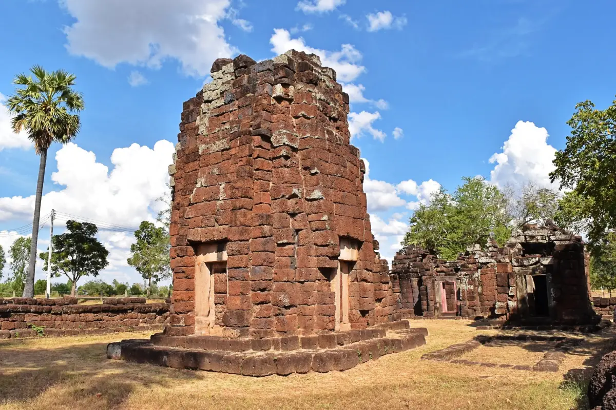
Prasat Nang Ram
Open Days: Daily
Opening Hours: 08:30 – 16:30
Prasat Nang Ram, also known as Nang Ram Stone Sanctuary, is an important Khmer archaeological site in Prathai District, Nakhon Ratchasima Province. It stands in Ban Nang Ram, Nang Ram Subdistrict, within the quiet agricultural landscape of northeastern Thailand. The significance of the site extends far beyond its surviving laterite walls and sandstone architectural fragments. Prasat Nang Ram was a Saugatālaya, a Buddhist chapel associated with an Arokayasala or ancient hospital complex constructed during the reign of King Jayavarman VII around the 13th century CE. It therefore preserves evidence of the relationship between Mahayana Buddhism, public healthcare, royal administration, transportation networks, and ancient settlement. The sanctuary is open daily from 08:30 to 16:30, admission is free, and travelers should allow at least 1 hour to explore both Prasat Nang Ram and the adjoining Ku Phrom Chamsin archaeological complex.
Prasat Nang Ram is not a monumental complex on the scale of Phimai or Phanom Rung. Its appeal lies in its relatively compact plan, tranquil surroundings, and the opportunity to examine architectural elements at close range. Visitors can observe the remains of the central sanctuary, its projecting entrance porch, the eastern gateway pavilion, the laterite enclosure, an auxiliary building, and a small laterite-lined pond. The open rural setting is rarely crowded, making the site particularly rewarding for travelers interested in archaeology, Khmer architecture, cultural landscapes, and lesser-known historical destinations in Thailand.
In the context of Khmer architecture, the Thai word prasat does not necessarily mean a royal palace or fortified castle. It refers primarily to a sacred structure built to enshrine a revered image and provide a focal point for religious ceremonies. The central sanctuary represented the most sacred part of the compound, while the enclosure, gateway, auxiliary buildings, and water features established a carefully ordered transition from the secular world to the ritual interior. Understanding the complete layout is therefore essential. The surviving stones should not be viewed as isolated ruins but as parts of a coordinated architectural and symbolic system.
Prasat Nang Ram dates from the 18th Buddhist century, corresponding broadly to the late 12th or early 13th century CE, during the reign of King Jayavarman VII. The king is remembered for an extensive construction program that included Buddhist sanctuaries, roads, bridges, rest houses, and Arokayasala hospital complexes across territories connected to the Khmer Empire. These projects expressed a political ideal in which Mahayana Buddhist compassion was incorporated into royal government. The treatment of illness was consequently understood in both physical and spiritual terms, linking medicine with religious merit, ritual protection, and the duty of the ruler to relieve suffering.
Archaeologists describe Prasat Nang Ram more precisely as a Saugatālaya, or Buddhist chapel belonging to an Arokayasala. This distinction is important because the surviving stone sanctuary was not the entire hospital. It formed the sacred component of a larger medical institution that would also have required spaces for attendants, patients, supplies, medicinal preparation, water, and daily activities. Buildings made from timber or other perishable materials have largely disappeared, while the laterite and sandstone chapel remains as the most visible evidence of the original complex.
The architectural form of Prasat Nang Ram is associated with the Bayon style of the Jayavarman VII period. Laterite was used extensively for foundations, walls, the enclosure, and several structural components. Sandstone was reserved for doorframes, lintels, carved details, and sculptures because its finer texture allowed craftsmen to create more precise forms. Laterite could be quarried and cut while still relatively soft and hardened after exposure to air, making it a practical material for large-scale construction in the region. The combined use of the 2 materials reflects both technical efficiency and a clear understanding of their different structural properties.
The central sanctuary faces east, the principal orientation of many Khmer religious monuments and a direction closely associated with sunrise. A projecting porch once extended from the eastern side, creating a formal approach to the inner chamber. Although the upper structure and portions of the walls have collapsed, the surviving base, doorway alignment, and architectural fragments still allow visitors to reconstruct the original form mentally. The eastern orientation also corresponds with the position of the main gateway, establishing a direct ceremonial axis through the compound.
An auxiliary laterite building stands southwest of the central sanctuary. Local descriptions often call it a vihara, while in the broader vocabulary of Khmer architecture it may be interpreted as an ancillary structure or library. Its entrance faces west, creating a deliberate relationship with the central courtyard. Its position and orientation are consistent with recurring patterns found at several Arokayasala chapels. By examining the doorway, foundation, and distance from the central sanctuary, visitors can see that the building was not placed randomly but formed part of a standardized and carefully organized plan.
The sanctuary and its auxiliary building were enclosed by a laterite wall that separated the sacred precinct from the surrounding area. The enclosure served not merely as a defensive feature but as a symbolic boundary between ordinary space and the ritual interior. The main entrance was positioned on the east and took the form of a cruciform gopura, or gateway pavilion. Its projecting wings created a transitional space in which worshippers moved from the exterior into the protected courtyard. Even where only foundations remain, walking through the original location of the gopura helps visitors understand the controlled progression toward the central shrine.
Outside the northeastern section of the enclosure is a small pond lined with laterite. Water was essential to an Arokayasala complex for drinking, washing, medicinal preparation, daily maintenance, and ritual purification. Placing the pond outside the sacred enclosure but close to the entrance made it accessible without disturbing ceremonies inside. Travelers should look closely at the pond’s edges, changes in ground level, and its alignment with the entrance. These features demonstrate that ancient builders considered drainage, water access, and the practical operation of the institution as integral parts of the site plan.
Local tourism descriptions traditionally present Prasat Nang Ram as 2 adjacent groups of monuments. The first is the Jayavarman VII-period Arokayasala chapel. South of it stands another complex with 3 principal towers arranged along a north–south axis. The Fine Arts Department identifies this southern monument separately as Ku Phrom Chamsin. Recognizing the distinction is essential because the 2 groups were constructed in different periods and served different functions. They should not be treated as a single building phase simply because they occupy the same archaeological landscape.
Ku Phrom Chamsin is older than Prasat Nang Ram. Its architecture and carved lintels date it to the latter half of the 16th Buddhist century, corresponding broadly to the 11th century CE and the Baphuon style of Khmer art. The complex contained 3 principal towers aligned north to south on a shared base, with entrances facing east. Library buildings stood to the northeast and southeast, while an enclosure and a moat surrounded the sacred compound. Although much of the superstructure has collapsed, sandstone doorframes, foundations, and decorated lintels preserve important evidence of its original appearance.
The lintels associated with Ku Phrom Chamsin are among the most significant artistic features in the area. The Fine Arts Department records 6 important examples depicting subjects such as Indra riding the elephant Airavata, seated figures above kala faces, a bearded male figure accompanied by women, a sword-bearing guardian deity, Vishnu riding Garuda, and Varuna. Baphuon-style lintels commonly place a kala face near the lower center, with garlands emerging from its mouth and curling foliage arranged around divine or narrative figures. These carvings communicated religious meaning, directional protection, and the status of the sanctuary while displaying the skill of Khmer stone carvers.
The close proximity of a Baphuon-period sanctuary and a later Bayon-period hospital chapel makes Ban Nang Ram exceptionally valuable for understanding the long development of an ancient community. Ku Phrom Chamsin shows that an established settlement and religious center existed here by the latter half of the 16th Buddhist century. Several generations later, an Arokayasala was constructed nearby during the reign of Jayavarman VII. The sequence indicates continuity rather than a short-lived occupation. The community survived, adapted, and received new religious and public infrastructure over a period of several centuries.
The name Nang Ram, meaning dancer, is connected to a local account of a green-stone female dancing image that once stood approximately 1.5 km west of the auxiliary building. The figure became sufficiently well known to provide the name for the sanctuary and surrounding locality. The sculpture is no longer present at its original location, although traces of a shrine and stone pedestal remain. The story links the archaeological monument with local memory and illustrates how communities often name places after distinctive sacred objects that were once familiar landmarks.
The term dancer may bring to mind the apsaras and celestial female figures carved on Khmer monuments. However, the local record specifically describes a green-stone image made in the form of a female dancer without preserving enough information to establish its exact date, artistic style, or religious identity. Its importance today lies primarily in its role in the origin of the place-name. Visiting Prasat Nang Ram is therefore also an encounter with an absent object whose memory survives in the names of the village, subdistrict, and archaeological site.
Another major artifact discovered at Prasat Nang Ram is a standing male guardian holding a 3-pronged weapon. The sculpture functioned as a dvarapala protecting the entrance to the sacred compound. It was once suggested that the weapon might represent a vajra and that the figure could be Vajrapani, an interpretation compatible with a Mahayana Buddhist sanctuary. Comparative study of the face and weapon, however, indicates that the object was probably a trident with a broken shaft. The smiling guardian may therefore represent Nandikesvara, traditionally paired with the fierce Mahakala as a protector of sacred buildings.
The interpretation of this guardian demonstrates that Khmer religious art did not always separate Hindu and Buddhist imagery into rigid categories. Protective figures familiar from Shaiva or Vaishnava temples could also appear at Buddhist monuments. Artistic conventions, workshop practices, and the general concept of guarding sacred space allowed symbols to move across religious contexts. Prasat Nang Ram consequently offers a useful example of interaction and continuity among religious traditions rather than a monument defined by a single, isolated iconographic system.
Prasat Nang Ram was officially registered as a national ancient monument in the Royal Gazette, Volume 53, Part 34, dated 27 September 1936. The protected archaeological boundary was formally declared on 30 June 1981 and covers approximately 13 rai, 2 ngan, and 92 square wah. National registration places the site under Thai legislation governing ancient monuments and antiquities. Visitors must not climb unstable walls, move stones, remove fragments, carve names into surfaces, or undertake any activity that could damage archaeological evidence.
The monument has undergone conservation and landscape improvement so that it can function as a historical learning site and community attraction. Archaeological conservation does not involve rebuilding a complete temple according to modern imagination. Its purpose is to stabilize surviving structures, preserve original materials, document evidence, and make the layout understandable. The laterite alignments visible today should therefore be read as archaeological information identifying walls, building foundations, entrances, courtyards, and circulation routes rather than as random piles of weathered stone.
A visit should begin from the east, the original ceremonial front of the sanctuary. From this position, travelers can identify the former gateway, the enclosure, and the central shrine arranged on the same axis. Walking along this route recreates the gradual movement from the exterior toward the sacred center. After examining the main sanctuary, continue toward the auxiliary building in the southwest, follow the line of the enclosure, and then inspect the pond to the northeast. The route can then be extended south to Ku Phrom Chamsin, where the earlier architectural phase becomes visible.
Details worth examining include the porous texture of laterite, the smoother surface of sandstone, joints between blocks, surviving doorway frames, foundation lines, and changes in ground elevation. Laterite generally appears reddish brown and naturally pitted, while sandstone has a finer texture and was better suited to carved architectural elements. Identifying the 2 materials helps explain how builders matched each stone to a specific purpose. Walls and broad structural masses were usually constructed from laterite, while frames, lintels, sculptures, and carefully finished details required sandstone.
Morning is particularly suitable for photographing the eastern entrance because sunlight emphasizes the texture of the laterite and illuminates the formal approach to the central shrine. Late afternoon offers softer light and lower temperatures. Most of the archaeological area is outdoors, so visitors should carry drinking water, a hat or umbrella, and shoes suitable for grass and uneven ground. During the rainy season, sections of the site may become slippery. In the hot season, midday temperatures can be severe, making an early or late visit considerably more comfortable.
Photographers should try to show relationships among the buildings instead of concentrating exclusively on close views of individual ruins. A photograph from the east can capture the entrance axis and central sanctuary. Side angles reveal the auxiliary structure and enclosure, while the pond provides an opportunity to illustrate the role of water in the plan. Remaining at ground level and avoiding the temptation to stand on walls or stone blocks protects fragile structures and produces images that better communicate the archaeological context.
The atmosphere differs from that of a major historical park. Prasat Nang Ram remains closely connected to a rural community, agricultural land, and the quiet rhythm of local life. Wind, birds, and sounds from nearby households replace the crowds and commercial activity found at larger attractions. This setting helps visitors imagine why an ancient hospital complex was established here. Such an institution needed access to residents, water, travel routes, supplies, and an existing settlement. The sanctuary was part of a living landscape rather than an isolated monument in an empty field.
Visitors should behave respectfully even though the monument is no longer an active temple requiring a formal dress code. Modest clothing, quiet conduct, and proper disposal of rubbish are appropriate. Stones and architectural fragments must not be touched, shaken, or removed. Even a small fragment may contain information about construction, chronology, or decoration. Adults accompanying children should ensure that they do not climb foundations or unstable walls.
Allow approximately 1–2 hours to explore Prasat Nang Ram and Ku Phrom Chamsin properly. A quick overview may take around 45 minutes, but travelers interested in architecture should walk around the enclosure, examine the pond, compare the 2 building phases, and study the remaining sandstone elements. The additional time makes the difference between simply photographing ruins and understanding the contrast between the earlier Baphuon-style sanctuary and the later Bayon-style Arokayasala chapel.
Facilities at the site are basic. Parking is available close to the monument, and the archaeological remains can be explored through an open outdoor area. There is no large visitor center or extensive range of shops and services. Travelers should refuel, purchase water, and use restrooms at service stations or businesses in the surrounding communities before arriving. Older visitors can enjoy views from the outer area, although sections of the ground are uneven. Wheelchair users should travel with assistance and assess the surface conditions before approaching the foundations.
Getting There from Nakhon Ratchasima city requires following Highway 2, the Nakhon Ratchasima–Khon Kaen route, for approximately 62 km to the Ban Wat intersection. Turn right onto Highway 207 and continue for about 22 km to Ban Ya Kha, located approximately 11 km before central Prathai. Turn left onto the local road toward Wat Prasat Nang Ram and continue for another 4 km to the archaeological site. The final section passes through rural communities and farmland. Navigation should be set to approximately 15.502933, 102.622930.
Travelers beginning in central Prathai should follow Highway 207 toward Ban Ya Kha and then turn into Nang Ram Subdistrict. The driving distance from the town area is approximately 14–16 km, depending on the starting point. Visitors arriving from Khon Kaen can travel south on Highway 2 through Phon and Bua Yai before connecting with Highway 207. Those approaching from Buriram or Phimai should use the road network around Phimai and follow navigation carefully, as several local junctions occur along the route.
A private car or rental vehicle is the most convenient transport option because scheduled public vehicles do not travel directly to the monument. Travelers using public transport can reach Prathai town and arrange a local hired vehicle for the final journey. The fare, return time, and meeting point should be agreed upon before leaving town, as taxis or local vehicles do not wait regularly at the archaeological site. Saving the location pin and the telephone number of the driver or accommodation is advisable.
A 1-day cultural route can begin at Prasat Nang Ram and Ku Phrom Chamsin in the morning, followed by lunch in Prathai town and a visit to Kanchanaphisek Park or local temples. Travelers with a private vehicle can continue to Prang Ban Sida in Bua Yai District or connect the journey with Phimai Historical Park and Phimai National Museum. Combining the sites reveals how Khmer religious monuments and communities were distributed across northern Nakhon Ratchasima and how different places were connected through regional movement and settlement.
Most restaurants and cafés are concentrated in central Prathai, approximately 14–15 km from Prasat Nang Ram. Suitable stops include Café Baan Mee by Ko Tae, Baan Cake Prathai by Wanthong, The Mee Tang Café & Restaurant, Baan Suan Coffee & Restaurant, and Boeng Bueng. Accommodation is available in both Nang Ram Subdistrict and the Prathai town area. Nearby options include Lake Resort Korat, Crystal Place Prathai, Ingdao Resort, Bed Box, and Diary Resort Prathai.
Prasat Nang Ram is especially suitable for school groups, university students, families, and independent travelers seeking to learn from an actual archaeological landscape. The site can be used to explain construction materials, orientation, water management, Mahayana Buddhist belief, public healthcare, and the role of the state in ancient society. Comparing the monument with Ku Phrom Chamsin demonstrates how artistic styles and religious institutions changed over time while the surrounding community remained important.
From the perspective of social history, the Arokayasala shows that medicine was not separated from religion and political administration. Healing was connected to merit, ritual protection, sacred images, and the provision of resources by the community and state. Constructing a religious chapel at a hospital therefore communicated both the king’s authority and the principle that a ruler had a responsibility to relieve the suffering of the population.
The sanctuary also broadens the understanding of Khmer influence in Thailand. This influence did not mean that every community possessed an identical population or culture. It reflects a network of political relationships, religious ideas, artistic forms, trade, and transportation linking many different communities. Local builders adopted models from major centers but adjusted them to available materials, terrain, labor, and local requirements. Each monument consequently combines recognizable regional features with details shaped by its immediate environment.
The value of Prasat Nang Ram does not depend solely on a complete tower or spectacular carvings. Its importance lies in the evidence of an Arokayasala network, settlement continuity across several centuries, an ordered architectural plan, the story of the lost green-stone dancer, and the discovery of a guardian sculpture. Together, these elements transform the monument from a collection of ruins into a source for understanding healthcare, religion, art, royal policy, and community memory in ancient northeastern Thailand.
Prasat Nang Ram is therefore an excellent destination for travelers who appreciate quiet historical sites, wish to avoid heavily crowded attractions, and prefer to study the past through physical evidence. Before traveling, check the weather, prepare water, and save the coordinates. Begin from the east, follow the main axis toward the sanctuary, examine the auxiliary building and pond, and continue south to Ku Phrom Chamsin. This sequence allows the visitor to experience both the 13th-century hospital chapel and the remains of a community whose history reaches back to the 11th century within a single archaeological landscape.
| Name | Prasat Nang Ram, also known as Nang Ram Stone Sanctuary |
| Location | Ban Nang Ram, Nang Ram Subdistrict, Prathai District, Nakhon Ratchasima Province |
| Address | Nang Ram Subdistrict, Prathai District, Nakhon Ratchasima 30180, Thailand |
| Coordinates | 15.502933, 102.622930 |
| Highlights | A Saugatālaya or Buddhist chapel associated with a Jayavarman VII-period Arokayasala, adjoining the older Ku Phrom Chamsin sanctuary |
| History And Period | Built around the 18th Buddhist century during the reign of King Jayavarman VII in the Bayon style as the sacred component of an Arokayasala hospital complex |
| Name Origin | Named after a green-stone female dancer image formerly located approximately 1.5 km west of the auxiliary building; traces of its shrine and stone pedestal remain |
| Distinctive Features | East-facing central sanctuary, southwestern auxiliary building, laterite enclosure, cruciform eastern gopura, and a laterite-lined pond to the northeast |
| Important Artifact | A male guardian holding a 3-pronged weapon, interpreted as possibly representing Nandikesvara carrying a trident |
| Protected Area | Approximately 13 rai, 2 ngan, and 92 square wah |
| National Registration | Registered as a national ancient monument on 27 September 1936; protected boundary declared on 30 June 1981 |
| Main Areas And Zones | 1. Prasat Nang Ram Arokayasala chapel: central sanctuary, auxiliary building, enclosure, gopura, and pond 2. Ku Phrom Chamsin: 3 principal towers, library buildings, enclosure, decorated lintels, and moat |
| Open Days | Daily |
| Opening Hours | 08:30 – 16:30 |
| Admission Fee | Free admission |
| Recommended Visit Duration | Approximately 1–2 hours for both Prasat Nang Ram and Ku Phrom Chamsin |
| Facilities | Parking close to the archaeological site and an open outdoor walking area; visitors should carry water, sun protection, and suitable footwear |
| Travel Information | From Nakhon Ratchasima, follow Highway 2 for approximately 62 km to Ban Wat intersection, turn onto Highway 207 for about 22 km to Ban Ya Kha, then turn left and continue another 4 km toward Wat Prasat Nang Ram |
| Current Status | Open to visitors as a protected national ancient monument and community historical learning site |
| Caretaker | Fine Arts Department through the 10th Regional Office of Fine Arts, Nakhon Ratchasima, in coordination with local authorities and the community |
| Official Contact Number | 10th Regional Office of Fine Arts, Nakhon Ratchasima: +66 44 471 518 |
| Official Information | Nang Ram Subdistrict Administrative Organization and the 10th Regional Office of Fine Arts, Nakhon Ratchasima |
| Nearby Tourist Attractions | 1. Ku Phrom Chamsin, approximately 0.3 km 2. Kanchanaphisek Park, Prathai, approximately 15 km 3. Wat Aran Phrommaram, approximately 20 km 4. Prang Ban Sida, approximately 28 km 5. Phimai Historical Park, approximately 55 km |
| Nearby Restaurants | 1. Café Baan Mee by Ko Tae, approximately 14 km, Tel. +66 84 755 9394 2. Baan Cake Prathai by Wanthong, approximately 14 km, Tel. +66 83 276 6228, +66 89 717 0199 3. The Mee Tang Café & Restaurant, approximately 15 km, Tel. +66 85 856 3958 4. Baan Suan Coffee & Restaurant Prathai, approximately 15 km 5. Boeng Bueng, approximately 14 km |
| Nearby Accommodations | 1. Lake Resort Korat, approximately 8 km, Tel. +66 98 625 5434 2. Crystal Place Prathai, approximately 14 km, Tel. +66 80 001 0021 3. Ingdao Resort, approximately 15 km, Tel. +66 84 416 3249 4. Bed Box, approximately 17 km, Tel. +66 88 226 6266 5. Diary Resort Prathai, approximately 17 km |
Frequently Asked Questions (FAQ)
Q: Where is Prasat Nang Ram located?
A: Prasat Nang Ram is located in Ban Nang Ram, Nang Ram Subdistrict, Prathai District, Nakhon Ratchasima Province, at approximately 15.502933, 102.622930.
Q: What days and hours is Prasat Nang Ram open?
A: The archaeological site is open daily from 08:30 to 16:30. Morning or late afternoon visits are recommended to avoid the strongest heat.
Q: Is there an admission fee for Prasat Nang Ram?
A: Admission is free. Visitors may explore the archaeological area while following all conservation rules.
Q: When was Prasat Nang Ram constructed?
A: It was built around the 18th Buddhist century during the reign of King Jayavarman VII as a Saugatālaya or Buddhist chapel associated with an Arokayasala hospital complex.
Q: How did Prasat Nang Ram receive its name?
A: The name comes from a green-stone female dancer image that once stood approximately 1.5 km west of the auxiliary building. Traces of its shrine and stone pedestal remain.
Q: Are Prasat Nang Ram and Ku Phrom Chamsin the same monument?
A: They are adjoining archaeological complexes from different periods. Ku Phrom Chamsin dates from approximately the latter half of the 16th Buddhist century, while Prasat Nang Ram was built in the 18th Buddhist century.
Q: How much time should visitors allow at Prasat Nang Ram?
A: Allow approximately 1–2 hours to explore the central sanctuary, auxiliary building, enclosure, gateway, pond, and the adjoining Ku Phrom Chamsin complex.
Q: Can Prasat Nang Ram be reached by public transport?
A: Scheduled public transport does not travel directly to the monument. Travelers can reach Prathai town and arrange a local hired vehicle, preferably with a return journey agreed in advance.
 Category: ●Art, Culture and Heritage
 Group: ●Historical Sites and Monuments
Last Update : 3 MonthAgo
 Last Update : 3 MonthAgo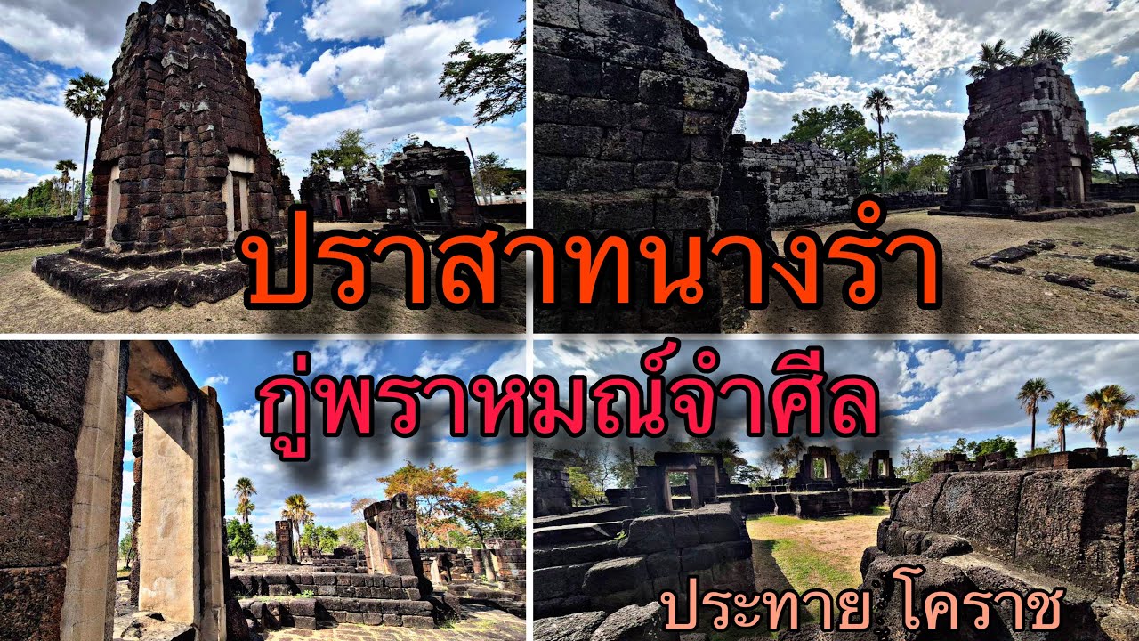
 Click to Access the Navigation Map GPS
Prasat Nang Ram Map
Recommend
 Historical Sites and Monuments(20)
 Landmarks and Memorials(5)
 Art, Craft Centres, Tradition(7)
 Museums(6)
 Art Gallery(1)
 Educational Places
 Educational Gardens, Farm(4)
 Places of Worship
 Temple(29)
 Mosque(1)
 Other Sacred Sites(6)
 Research and Development
 Royal Project(3)
 Suburban Living
 Village, Community(6)
 Local Market(4)
 Floating Market(1)
 Nature and Wildlife
 National Parks and Marine Reserves(3)
 Mountain (Doi)(5)
 Dam, Reservoir, Lake(8)
 Waterfalls(9)
 Hot Springs(1)
 Caves(2)
 Flower Field(1)
 River, Canal(8)
 Bays and Beaches(2)
 Other natural attractions(3)
 Entertainment and Agricultural
 Zoos and Aquariums(2)
 Animal camps and shows(1)
 Farms, Parks and Ecotourism(21)
 Waterpark(4)
 Outdoor and Adventure Activities(6)
 Shopping
 Shopping and Night Market(2)
 Travel Articles, Recipes
 Travel Review, Food Review(6)


