
lovethailand home >Northeastern Travel Attractions >Nakhon Phanom Travel Attractions >Ban Phaeng >Phai Lom > Tat Pho Waterfall
TL;DR: Tat Pho Waterfall is located at Phu Langka National Park, Phai Lom Subdistrict, Ban Phaeng District, Nakhon Phanom Province, Thailand, open Daily during the open season. In 2026, the waterfall and associated nature, hours 07:00 – 15:00.

Tat Pho Waterfall
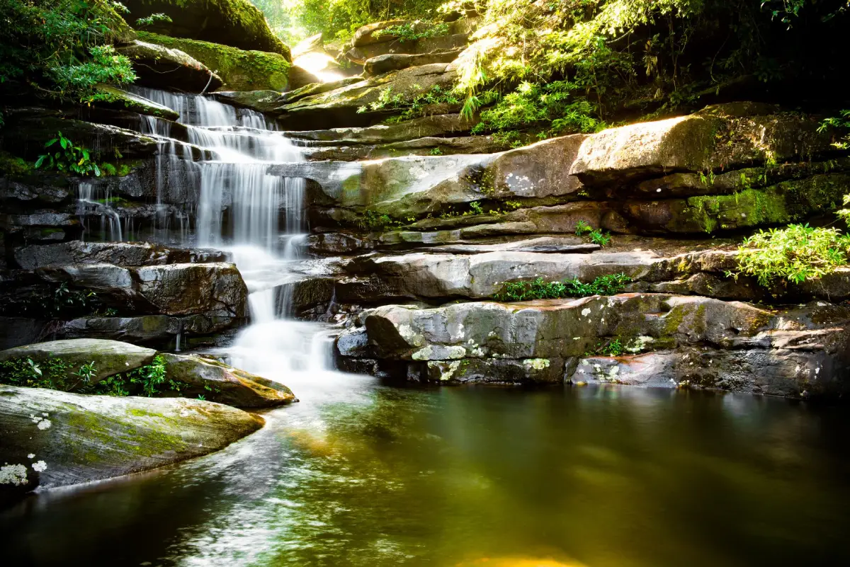
Open Days: Daily during the open season. In 2026, the waterfall and associated nature trails were closed for ecological recovery from 1–30 June and reopened on 1 July 2026.
Opening Hours: 07:00 – 15:00
Tat Pho Waterfall in Nakhon Phanom Province, also written as Tad Pho Waterfall, is a multi-tiered natural waterfall within Phu Langka National Park in Ban Phaeng District. The waterfall originates in the highlands of the Phu Langka mountain range, where rainwater gathers in forested watersheds before flowing into Huai Langka and descending across a series of sandstone cliffs. It is commonly described as having four principal tiers, surrounded by lush forest, rocky streams, seasonal wildflowers, butterflies, birds, and distinctive sandstone formations. The waterfall is approximately 3 kilometres from Ban Na Pho and about 5 kilometres from Highway 212, the main Nakhon Phanom–Nong Khai route.
Essential information for visitors Tat Pho Waterfall is at its most impressive after the annual ecological closure in June, particularly from July to September, when the forest is green and the stream normally carries a substantial volume of water. Visitors who only wish to see the lower falls can complete a relatively short walk, while those continuing to the upper tiers, Naki Cave, or Pha Naki Viewpoint need suitable hiking shoes, drinking water, rain protection, and sufficient time. Registration and compliance with national park instructions are required for the upper nature trails. Admission for Thai visitors is 20 baht for adults and 10 baht for children. The foreign visitor rate is 200 baht for adults and 100 baht for children, with separate vehicle charges.
A waterfall shaped by the Phu Langka mountains Tat Pho Waterfall is not simply a single drop of water over one cliff. Its landscape is formed by the interaction of a mountain watershed, forest cover, sandstone beds, natural fractures, and a stream that changes in volume throughout the year. The Phu Langka range extends broadly parallel to the Mekong River. Its elevated plateaus and slopes collect rainfall and release it gradually into streams, creating cascades, pools, rocky channels, and cliff edges at different elevations.
The watershed above the waterfall contains several forest types, including dry evergreen forest, mixed deciduous forest, and dry dipterocarp forest in areas with shallower soil. These forests slow surface runoff, retain moisture, reduce soil erosion, and protect the quality of the water flowing downstream. The condition of Tat Pho Waterfall therefore depends on the conservation of the wider mountain forest rather than the immediate waterfall area alone.
During the rainy season, water collected across the plateau flows into the stream in larger quantities. The waterfall becomes wider and more powerful, its sound travels through the valley, and fine spray cools the surrounding vegetation. Toward the end of the rainy season, water levels gradually decline, exposing more of the sandstone ledges, natural pools, and channels. As a result, the appearance and character of the waterfall vary considerably according to the month, rainfall, and conditions in the upstream catchment.
How many tiers does Tat Pho Waterfall have? Provincial tourism information traditionally groups Tat Pho Waterfall into four principal tiers. This description follows the main route from the lower waterfall near the visitor facilities to the upper cliff area connected with Pha Ngoi, Pha Naki, and Naki Cave. Along the stream, however, there are additional small cascades, rapids, ledges, and intermediate drops. Some park signs and field descriptions may therefore identify more numbered waterfall points. For practical travel planning, the four-tier description remains the clearest way to understand the principal sections of the route.
The first tier is the easiest section to reach. It is approximately 100 metres from the parking and visitor service area, allowing families, older travelers, and visitors with limited time to experience the waterfall without undertaking a long mountain hike. The area contains shaded rocks, flowing water, forest vegetation, and places where visitors can stop to observe the stream.
Easy access does not mean that the first tier is free from risk. Wet sandstone and algae can make the surface extremely slippery, particularly after heavy rain. Visitors should not run, jump between rocks, or approach sections where the current is strong. Children must remain under close adult supervision, and all warning signs or instructions from park officers should be followed immediately.
The second tier is approximately 200 metres beyond the first. Here, the stream begins to cross higher rock faces and broader sandstone slabs before falling into a pool below. The area is sometimes associated with the name Pha Sawan Waterfall. The larger drop and clearer view of the rock formation make it a popular photography location, although visitors must choose stable ground and avoid blocking the path while taking photographs.
The short walk between the first and second tiers introduces visitors to a more natural forest setting. Sounds from the service area fade and are replaced by running water, insects, and birds. The trail also reveals the contrast between humid streamside vegetation and plants growing on drier slopes or shallow soil away from the water.
The third tier, known as Sai Ngam Waterfall, is approximately 1.5–1.7 kilometres from the park office along the trail. Reaching this area requires more effort than visiting the first two tiers. The water spreads across rock faces in a quieter and more densely forested setting. Visitors should allow sufficient time for the return journey, avoid beginning the upper walk late in the afternoon, and assess their health and fitness before proceeding.
Sections of the route to Sai Ngam Waterfall include slopes, exposed rocks, damp soil, and muddy areas after rain. Ordinary footwear with a smooth sole can become unsafe. Hiking shoes should fit securely and provide reliable grip. Clothing should be lightweight, quick-drying, and close enough to the body to avoid catching on branches or vines beside the trail.
The fourth tier around Pha Ngoi and Pha Naki lies approximately 2 kilometres from the starting area. It is the highest of the four principal sections and contains a prominent cliff approximately 50 metres high. The waterfall descends from the sandstone edge against a backdrop of Phu Langka forest. This upper area forms part of the nature route leading toward Naki Cave and Pha Naki Viewpoint and is most suitable for visitors who are physically prepared for mountain hiking.
Naki Cave is approximately 300 metres beyond the upper waterfall, while Pha Naki Viewpoint is another 500 metres beyond the cave. Although these figures appear short, the terrain includes steep sections, uneven sandstone, wet ground, and repeated elevation changes. The route requires considerably more effort than the same distance on a paved road. Visitors must register, confirm access times, and comply with current park regulations before entering the upper trail.
The connection between Tat Pho Waterfall and Naki Cave makes this destination different from a conventional waterfall visit. Travelers can follow the mountain stream and sandstone cliffs toward a geological landscape noted for weathered rock surfaces, unusual patterns, and formations popularly compared with the scales of a mythical naga. The combination of geology, forest ecology, and cultural beliefs associated with the Mekong region attracts both hikers and travelers interested in spiritual traditions.
The Naki Cave trail should be treated as a sensitive natural environment rather than merely a location for photographs. Visitors should not scratch, mark, or remove material from the rock, place objects that become waste, or leave the designated route. Repeated trampling outside the trail damages moss, lichen, seedlings, and the thin layer of soil that supports vegetation on the mountain.
The sandstone landscape of Phu Langka provides the geological foundation of Tat Pho Waterfall. Sandstone contains bedding planes, fractures, and zones with different levels of resistance. Over long periods, rainfall, flowing water, temperature changes, and natural weathering remove softer material more rapidly than harder rock. This process forms ledges, cliffs, channels, pools, and irregular surfaces throughout the stream.
Water flowing from the mountain also transports small sediment, leaves, branches, and organic material from the watershed. These materials form part of the natural nutrient cycle. During high water, however, branches or stones carried by the current may become dangerous. Visitors should leave the stream immediately when the water turns cloudy, changes colour rapidly, rises unexpectedly, or begins carrying an unusual amount of debris.
Forest ecology and biodiversity are major reasons to walk slowly and pay attention to the environment rather than concentrating only on the main waterfall. The Phu Langka forest contains plants adapted to humid stream banks, shaded valleys, shallow sandstone soil, and seasonally dry slopes. During the rainy season and early cool season, visitors may see wildflowers, orchids, ferns, moss, and small plants growing in cracks and damp areas.
Butterflies often gather around moist ground, shallow pools, and mineral-rich patches, especially when sunshine appears after rain. They should be observed and photographed without being captured or disturbed. Birds, insects, and small forest animals may also be heard in the canopy even when they remain hidden from view.
Early morning is generally the best time for bird activity and a quieter forest atmosphere. Visitors should speak softly, avoid portable speakers, and refrain from playing recorded animal calls. Excessive noise can affect feeding, communication, nesting, and escape behaviour among wildlife.
The best season to visit Tat Pho Waterfall normally begins after the June ecological closure and continues from July to approximately October. July through September usually provides the strongest water flow and greenest vegetation, although frequent rain creates slippery trails and a higher risk of flash floods. October often brings easier walking conditions and remaining waterfall flow, but the volume of water begins to decline according to the rainfall pattern of each year.
Travelers seeking a powerful waterfall and a rain-forest atmosphere should visit during the middle of the wet season after checking current park notices. Those more interested in hiking and photographing exposed sandstone may prefer the later rainy season, when water does not cover every rock feature. A weather forecast for Ban Phaeng town alone cannot confirm safety on the mountain; visitors must also check same-day announcements from Phu Langka National Park.
Annual ecological closure is an important part of managing tourism in a national park. In 2026, Tat Pho Waterfall and the Naki Cave trail were closed from 1–30 June to allow ecological recovery, trail maintenance, and safety inspections before reopening on 1 July. Temporary closure reduces trampling while the soil is heavily saturated and gives officers time to inspect bridges, paths, signs, drainage, and hazardous sections.
In addition to a scheduled closure, the park may stop access immediately during heavy rain, flash-flood danger, strong wind, landslides, damaged trails, or other unsafe conditions. Travelers should not rely solely on old reviews or a previously published timetable. Calling the national park before departure reduces the risk of arriving when a route has been temporarily closed.
Flash-flood awareness is essential at any mountain waterfall. Heavy rain may occur in the upper watershed even when the entrance area remains dry. Once water accumulates across the plateau, stream levels can rise rapidly. Warning signs include water becoming muddy or changing colour, an unusual increase in sound, a rapid rise in water level, and large quantities of leaves, branches, or debris moving downstream.
When officers instruct visitors to leave, everyone should move immediately rather than remaining to take photographs or recover belongings close to the stream. Equipment can be replaced, but escaping from a narrow valley becomes difficult as water rises. Groups should agree on a meeting point and count all members before beginning the walk so that nobody is left behind during an emergency.
Swimming should only take place in areas permitted by the park and when the current is calm. Natural pools may have uneven depth, submerged holes, sharp rocks, or branches hidden beneath the surface. Visitors must not jump from cliffs or boulders or swim directly beneath a waterfall, where downward force and circulating water may cause loss of balance.
Children, older visitors, and people who are not confident swimmers should avoid deep pools. A life jacket can improve safety but does not replace an assessment of the current and weather. Alcohol should never be consumed before or during swimming because it reduces balance, judgement, and reaction time.
What to bring includes hiking shoes with a reliable sole, quick-drying clothing, a compact rain jacket, drinking water, energy-rich food, a waterproof bag, personal medication, and a small first-aid kit. Mobile phones should be fully charged, and park contact numbers should be saved before departure because mobile coverage is inconsistent on the upper trail.
Every visitor should carry a bag for removing personal waste. Food packaging, tissues, face masks, and plastic bottles must not be left at resting points. Food scraps should not be poured into the stream or left for wildlife, as this changes natural feeding behaviour and increases conflict between animals and people.
Appropriate clothing should be suitable for hot and humid conditions. A lightweight long-sleeved shirt helps protect the skin from insects and scratches. Flexible long trousers make climbing easier, while higher socks reduce friction and prevent soil from entering the shoes. Heavy clothing should be avoided because it traps heat and dries slowly.
During rain, a poncho or jacket should not be so long or loose that it hides the feet or catches on branches. A trekking pole can improve balance on slopes, but its tip should be placed carefully to avoid damaging plants beside the trail. Wet footwear should be cleaned and dried after the trip to reduce odour, mould, and deterioration.
Waterfall photography is possible with either a mobile phone or a dedicated camera. Morning light is softer and the number of visitors is often lower. Cloudy weather can reduce the strong contrast between bright sky and shaded forest. A tripod can help create a smooth-water effect, but it should only be used where it does not obstruct the trail, and all equipment should be protected from spray.
Visitors should never leave the marked route or climb unstable rocks for a unique photograph. Apparently dry sandstone may still be slippery or undercut. Drone use inside a national park is subject to legal requirements and prior permission from relevant authorities. Aircraft must not disturb wildlife, visitors, or park operations.
Travel from Ban Phaeng District follows Highway 212, the main Mekong-side route. Near kilometre marker 214, turn toward Phu Langka National Park and Tat Pho Waterfall, following local signs. The waterfall is approximately 3 kilometres from Ban Na Pho and about 5 kilometres from the main highway, depending on the access point used. Drivers should reduce speed during the rainy season because water, soil, and leaves may accumulate on the final approach.
Travel from Nakhon Phanom city follows Highway 212 through Tha Uthen District toward Ban Phaeng. The journey is approximately 107 kilometres and normally takes between 1 hour 30 minutes and 2 hours, depending on traffic and stops. Most of the route is paved and accessible to an ordinary passenger vehicle, although fuel should be sufficient before entering the mountain area.
Travelers approaching from Bueng Kan Province can also follow Highway 212 toward Ban Phaeng. The riverside route can be incorporated into a longer journey through northeastern Thailand, but the daily schedule should not be too crowded because hiking at Tat Pho Waterfall and Naki Cave requires time and must be completed within park access hours.
Public transportation is less convenient than using a private or rental vehicle. Interprovincial buses can bring travelers to Ban Phaeng, but a local hired vehicle, rental car, or transfer arranged by an accommodation provider is required for the final journey. The fare, pickup time, and return meeting point should be agreed before entering the park because regular public transport does not continuously serve the waterfall entrance.
A vehicle with a local driver is practical for travelers combining Tat Pho Waterfall, Tat Kham Waterfall, and Mekong-side sites around Ban Phaeng. It removes concerns about parking and the return drive after a tiring hike. The driver should be informed in advance that the itinerary includes a nature trail so that sufficient waiting time can be arranged.
A half-day itinerary is suitable for visitors concentrating on the lower waterfall. Arrive in the morning, register, ask officers about conditions, and walk to the first and second tiers. After allowing time for photography and observing the streamside forest, return to the visitor area before midday. This program requires less physical effort and leaves time for Tat Kham Waterfall or Ban Phaeng town in the afternoon.
A full-day itinerary requires arrival before the trail becomes busy, with food, water, and equipment prepared in advance. Hikers may continue from the lower tiers to Sai Ngam Waterfall, the fourth tier, Naki Cave, and Pha Naki Viewpoint when access is permitted. A firm turnaround time must be established even when the group has not reached every destination, as descending wet rock can take as long as climbing.
First-time hikers should begin with a shorter route rather than choosing an upper trail solely because of attractive photographs. Cardiovascular fitness, knee condition, muscle strength, and balance all affect safety. Travelers with medical conditions should carry medication, inform companions, and stop immediately if they experience dizziness, chest pain, abnormal breathing, or severe joint discomfort.
Visitor facilities are concentrated near the national park office and entrance area. They include parking, toilets, an information point, officer assistance, and designated camping or accommodation areas subject to park regulations. Facilities become extremely limited on the upper trail, so drinking water and essential supplies must be carried from the starting point.
Anyone planning to stay overnight should contact the park in advance regarding accommodation, camping areas, equipment, and current rules. Tents must be placed in designated areas rather than on riverside rocks or unofficial clearings, where flash floods, falling branches, and disturbance to nocturnal wildlife create significant risks.
National park admission is 20 baht for Thai adults and 10 baht for Thai children. The foreign visitor rate is 200 baht for adults and 100 baht for children. Motorcycles are charged 20 baht and four-wheel vehicles 30 baht. Guide services, porters, camping, accommodation, and special trail activities are not included in the admission rate. Visitors should carry a reasonable amount of cash because electronic payment and mobile reception may not be reliable at all times.
Management and protection Tat Pho Waterfall is administered by Phu Langka National Park under Thailand’s Department of National Parks, Wildlife and Plant Conservation. In 2026, the park superintendent was Mr. Aksorn Manawong (นายอักษร มานะวงศ์). Park responsibilities include watershed protection, visitor management, rescue operations, trail inspection, wildlife conservation, and recovery of areas affected by tourism.
Phu Langka National Park can be contacted at 084-792-3505 and 042-530-766, with information services generally available between 09:00 and 16:00. Visitors should ask about trail access, water conditions, weather, guide requirements, accommodation, and registration before traveling, especially on public holidays or after several days of rain.
Responsible nature tourism begins by carrying only what is necessary and removing everything brought into the forest. Visitors must not leave waste, use soap or shampoo in the stream, feed animals, collect flowers, remove stones, or mark trees and cliffs. A small action repeated by thousands of visitors can produce a major ecological impact.
Travelers should keep noise low, allow others to pass, and avoid occupying a photography point for an excessive period. Wildlife must be observed from a distance without blocking escape routes or using flash at close range. Respect for the landscape also includes understanding community beliefs without exaggerating local stories or treating culturally significant places merely as photographic props.
Importance to the Ban Phaeng community Tat Pho Waterfall is a natural resource, educational site, and component of the local tourism economy. Visitors who stay overnight, eat at local restaurants, purchase local products, or use transportation services help distribute income within the district. Choosing responsible services and paying fair prices strengthens the long-term connection between forest protection and community livelihoods.
A successful journey should not be measured only by the number of attractions visited in one day. It should also consider whether the trip benefits the destination and leaves minimal damage. Spending time learning from officers, observing the forest, and understanding park limitations gives a visit to Tat Pho Waterfall greater meaning than a brief stop for photographs.
Nearby attractions most directly connected with the waterfall are Naki Cave and Pha Naki Viewpoint on the upper nature trail. Visitors seeking a less demanding excursion can continue by road to Tat Kham Waterfall, approximately 4 kilometres away. Wat Pa Non Phaeng and Wat Phu Langka Tai add religious, community, and cultural dimensions to an itinerary around Ban Phaeng District.
Route planning should account for real walking time rather than map distance alone. Naki Cave is only around 300 metres beyond the fourth waterfall tier, but hikers must first climb from the trailhead. Attractions in Ban Phaeng town are geographically farther away but can be reached quickly by vehicle. Mountain hiking and community sightseeing should therefore be scheduled as separate parts of the day.
Restaurants and accommodation are concentrated in and around Ban Phaeng town, approximately 10–13 kilometres from the waterfall entrance. Visitors should eat or prepare supplies before entering the national park and should not assume that complete food services will be available along the trail. Staying overnight in Ban Phaeng allows an early start and avoids the fatigue of driving from Nakhon Phanom city immediately before a hike.
Travelers should telephone a restaurant or accommodation provider to confirm operating days, room availability, check-in time, and requested services. Smaller establishments may adjust their schedules seasonally. Guests departing before normal breakfast hours should ask about a packed meal or transportation arrangement in advance.
Tat Pho Waterfall as an outdoor classroom provides opportunities to study the relationship between watershed forest, sandstone geology, the water cycle, and visitor management. Families can use the lower route to introduce children to stream flow, natural pools, algae, and the importance of removing waste. Schools or environmental groups should coordinate with the park in advance so activities can be matched to group size and current conditions.
Learning about nature does not require collecting specimens. Photography, sketching, note-taking, and responsible identification applications have less impact than removing plants, stones, or insects. Unknown plants and animals should never be touched or eaten because some may be toxic, cause allergic reactions, or receive legal protection.
Health considerations Mountain weather can change rapidly. Shaded forest may feel cooler than Ban Phaeng town, but high humidity increases perspiration and dehydration. Visitors should drink at regular intervals rather than waiting until they feel thirsty and should eat before beginning the hike. Walking too quickly at the start may cause exhaustion before reaching the steepest sections.
Travel plans should be shared with someone who is not participating in the hike, including the intended destination, expected exit time, and park contact number. Group members should not walk far ahead or remain alone at the rear. Rest stops should be taken on wider ground away from dead branches and without blocking the trail.
Why Tat Pho Waterfall belongs in a Nakhon Phanom itinerary is that it reveals a side of the province beyond the Mekong River, Buddhist temples, and historic urban communities. The destination demonstrates the mountainous landscape, watershed forest, and hiking culture of northern Nakhon Phanom. Travelers can experience a sequence of waterfalls, continue to Naki Cave, and stay within the Ban Phaeng community as part of one integrated route.
Tat Pho Waterfall is particularly rewarding for travelers who do not rush. Its details are distributed across the stream, rock surfaces, trees, moss, butterflies, and sounds of the forest rather than being limited to the highest cliff. Remaining in the area long enough to observe changes in light, humidity, and water flow provides an experience that cannot be gained from a brief roadside stop.
Getting There The most convenient option is a private or rental vehicle. From Nakhon Phanom city, follow Highway 212 through Tha Uthen District toward Ban Phaeng for approximately 107 kilometres. Turn from the main road according to signs for Phu Langka National Park. Tat Pho Waterfall is approximately 3 kilometres from Ban Na Pho and around 5 kilometres from the Nakhon Phanom–Nong Khai highway. Arriving in the morning provides sufficient time for the trail, and visitors should contact Phu Langka National Park to confirm access before every trip.
Tat Pho Waterfall is therefore more than a rainy-season recreation site. It is an entry point into the sandstone geography of the Phu Langka range, the ecology of a mountain watershed, and a nature route connected with Naki Cave. Traveling with appropriate preparation, respecting park regulations, and minimizing environmental impact will help preserve the water, forest, and landscape for the Ban Phaeng community and future visitors.
| Name | Tat Pho Waterfall |
| Alternative English Name | Tad Pho Waterfall |
| Location | Phu Langka National Park, Phai Lom Subdistrict, Ban Phaeng District, Nakhon Phanom Province, Thailand |
| Address | Phu Langka National Park, Ban Phaeng District, Nakhon Phanom 48140, Thailand |
| Coordinates | 17.9852, 104.1390 |
| Highlights | Four principal waterfall tiers, sandstone cliffs, forest trails, Sai Ngam Waterfall, Naki Cave, and Pha Naki Viewpoint |
| Distinctive Features | A mountain stream descending over sandstone cliffs through protected watershed forest, with an upper cliff approximately 50 metres high |
| Principal Tiers | Four principal tiers, with additional small cascades and rapids along the stream |
| Water Source | Huai Langka and the watershed of the Phu Langka mountain range |
| Name Origin | “Tat” is an Isan and Lao term for a waterfall or rapid, while “Pho” appears in local place names including Ban Na Pho and Huai Tat Pho |
| Main Areas / Zones | 1. Visitor service area and parking 2. First waterfall tier near the trailhead 3. Second tier or Pha Sawan area 4. Third tier or Sai Ngam Waterfall 5. Fourth tier around Pha Ngoi–Pha Naki 6. Naki Cave and Pha Naki nature trail 7. Designated camping and accommodation area |
| Approximate Walking Distances | Parking to Tier 1: 100 metres; Tier 1 to Tier 2: 200 metres; Tier 3: 1.7 kilometres; Tier 4: 2 kilometres; Naki Cave: approximately 300 metres beyond the upper tier |
| Best Travel Period | July–October, with generally stronger flow from July to September |
| Open Days | Daily during the open season. In 2026, the site reopened on 1 July after ecological closure from 1–30 June. |
| Opening Hours | 07:00 – 15:00 |
| Fees | Thai visitors: Adults 20 baht, children 10 baht Foreign visitors: Adults 200 baht, children 100 baht Motorcycles 20 baht and four-wheel vehicles 30 baht |
| Facilities | Parking, toilets, visitor information, park officers, designated accommodation, and camping areas subject to park regulations |
| Travel Information | From Nakhon Phanom city, follow Highway 212 through Tha Uthen toward Ban Phaeng for approximately 107 kilometres. The waterfall is approximately 3 kilometres from Ban Na Pho and 5 kilometres from the Nakhon Phanom–Nong Khai highway. |
| Current Status | Open following the 1–30 June 2026 ecological closure. Trail access remains subject to weather and national park safety announcements. |
| Caretaker | Phu Langka National Park, Department of National Parks, Wildlife and Plant Conservation. The park superintendent in 2026 was Mr. Aksorn Manawong (นายอักษร มานะวงศ์). |
| Main Contact Numbers | 084-792-3505 and 042-530-766. Information service: 09:00–16:00. |
| Official Website / Official Page | Phulangka National Park Thailand official page and the Department of National Parks, Wildlife and Plant Conservation website |
| Nearby Tourist Attractions | 1. Naki Cave, 2.3 km walking distance 2. Pha Naki Viewpoint, 2.8 km walking distance 3. Tat Kham Waterfall, 4 km 4. Wat Pa Non Phaeng, 12 km 5. Wat Phu Langka Tai, 16 km |
| Nearby Restaurants | 1. Krua Isan Zaep 8 Saen, 10 km, Tel. 086-232-7268 2. Krua Khun Nai, 10 km, Tel. 085-924-4956 3. Seoul Chic, 11 km, Tel. 063-787-2882 4. Pha Chill Restaurant, 11 km, Tel. 092-923-8334 5. Jungle Cafe at Ban Phaeng Municipal Market, 11 km, Tel. 083-872-9808 |
| Nearby Accommodations | 1. JB Place Hotel, 10 km, Tel. 088-884-4419 2. Langkalagoon Hotel, 11 km, Tel. 098-498-3000 3. Chom Dao Resort, 12 km, Tel. 082-477-5704, 082-116-5942 4. Khruea Khao View Resort, 12 km, Tel. 089-618-2004 5. Phu View, 13 km, Tel. 097-939-4744 |
Frequently Asked Questions (FAQ)
Q: Where is Tat Pho Waterfall located?
A: Tat Pho Waterfall is inside Phu Langka National Park in Phai Lom Subdistrict, Ban Phaeng District, Nakhon Phanom Province. It is approximately 3 kilometres from Ban Na Pho and around 5 kilometres from Highway 212.
Q: How many tiers does Tat Pho Waterfall have?
A: Provincial tourism information describes four principal tiers, extending from the lower waterfall near the visitor area to the upper Pha Ngoi–Pha Naki section. Additional small cascades and rapids occur along the stream.
Q: What are the opening hours and admission fees?
A: During the open season, access is from 07:00 to 15:00. Admission is 20 baht for Thai adults and 10 baht for Thai children. Foreign adults pay 200 baht and foreign children 100 baht. Vehicle fees are charged separately.
Q: When is the best time to visit Tat Pho Waterfall?
A: July to October is generally the best period. Water flow is normally strongest from July to September, although visitors must check weather and park announcements because heavy rain can close the trail.
Q: Can visitors walk from Tat Pho Waterfall to Naki Cave?
A: Yes. Naki Cave is approximately 300 metres beyond the upper waterfall, but the complete walk from the trailhead is around 2.3 kilometres over mountain terrain. Registration and compliance with park access rules are required.
Q: Is Tat Pho Waterfall suitable for children and older travelers?
A: The first tier is approximately 100 metres from the parking area and is the most accessible section. Upper tiers involve slopes, rocks, and longer walking distances, so individual health and mobility must be assessed before continuing.
Q: What should visitors bring for the hike?
A: Bring hiking shoes with good grip, a rain jacket, drinking water, energy-rich food, a waterproof bag, personal medication, a small first-aid kit, and a bag for carrying all waste out of the park.
Q: Is swimming allowed at Tat Pho Waterfall?
A: Swimming is permitted only in areas approved by the national park and when the current is safe. Do not enter the water during heavy rain, muddy flow, rapidly rising water, or a flash-flood warning, and never jump from cliffs or boulders.
 Category: ●Nature and Wildlife
 Group: ●Waterfalls
Last Update : 3 MonthAgo
 Last Update : 3 MonthAgo
 Click to Access the Navigation Map GPS
Tat Pho Waterfall Map
Recommend

 Art, Culture and Heritage
 Historical Sites and Monuments(3)
 Landmarks and Memorials(2)
 Art, Craft Centres, Tradition(3)
 Museums(3)
 Educational Places
 Library(1)
 Places of Worship
 Temple(23)
 Church(1)
 Other Sacred Sites(11)
 Suburban Living
 Village, Community(5)
 National Parks and Marine Reserves(1)
 Dam, Reservoir, Lake(5)
Waterfalls(2)
 River, Canal(3)
 Bays and Beaches(3)
 Other natural attractions(2)
 Entertainment and Agricultural
 Zoos and Aquariums(1)
 Farms, Parks and Ecotourism(2)
 Shopping
 Shopping and Night Market(1)
 Travel Articles, Recipes
 Travel Review, Food Review(1)


