
lovethailand home >Northeastern Travel Attractions >Surin Travel Attractions >Sang Kha >Ta Tum > Huai Khanat Mon Reservoir
TL;DR: Huai Khanat Mon Reservoir is located at Moo 5, Ban Khayong, Ta Tum Subdistrict, Sangkha District, Surin Province, Thailand, open Daily, hours 08.00 – 17.00.
Huai Khanat Mon Reservoir
Open Days: Daily
Opening Hours: 08.00 – 17.00
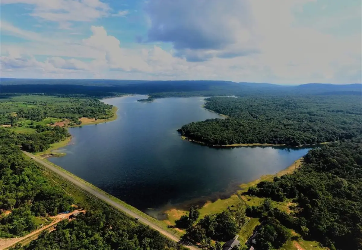
Huai Khanat Mon Reservoir in Surin, also known locally as Huai Khanat Mon Dam or Khayong Dam, is a scenic reservoir and waterfront recreation area in Ta Tum Subdistrict, Sangkha District, Surin Province. Located at Moo 5, Ban Khayong, the reservoir sits within the natural landscape of the Phanom Dong Rak mountain range. It is surrounded by hills, forest edges, rural communities, and a wide body of water. Its most distinctive feature is a sandy beach stretching for about 1 kilometer, creating a rare beach-like setting in southern Surin.
Huai Khanat Mon is one of the most interesting water-based attractions in Sangkha District because it combines reservoir scenery, mountain views, a local beach atmosphere, and community life in one place. Visitors come here to relax by the water, walk along the sand, take photographs, play in safe shallow areas, enjoy the breeze, and experience a quieter side of Surin Province. The destination is especially meaningful for travelers who want to see southern Surin beyond city temples, elephant culture, silk weaving, and Khmer ruins.
The reservoir is located in Ta Tum Subdistrict, in the southern part of Sangkha District, close to the Phanom Dong Rak mountain landscape. The surrounding area includes hills, farmland, local roads, forested sections, and villages that have long been connected with water resources. From the reservoir edge, visitors can see a broad water surface with green mountain lines in the background, giving the place a calm and spacious character.
The name Huai Khanat Mon is connected with Ban Khanat Mon and local waterways in the area. The place is also called Khayong Dam because of its association with Ban Khayong, the village located near the reservoir. The name therefore carries community meaning as well as geographical meaning. It refers not only to the water body itself, but also to the settlement history and local identity of Ta Tum Subdistrict.
Local history gives the reservoir deeper meaning. Before the construction of the dam, parts of the area were connected with the old Ban Khayong settlement and local routes. After water storage began, some low-lying areas were flooded, and the village moved to higher ground. This history makes Huai Khanat Mon more than a simple recreation site. The reservoir holds the memory of a community landscape that changed because of water development.
The most memorable feature of Huai Khanat Mon is its beach-like waterfront. The water edge does not drop suddenly; instead, it slopes gradually like a natural beach. This creates areas where visitors can enjoy the water in a relaxed way, especially during the hot season and long holidays. Several spots around the reservoir are known for this gentle slope, making the site popular with local families and groups of friends.
The sandy beach, approximately 1 kilometer long, gives the reservoir its unique identity. Walking along the sand while looking toward the water and mountains creates a different feeling from ordinary reservoirs. The beach makes the area more open, more comfortable for leisure, and more visually attractive for photography. This is why the destination is often remembered as a local beach in the mountains of Sangkha.
The atmosphere changes beautifully throughout the day. In the morning, the area is quiet, with soft light, cooler air, and occasional mist over the water during the cool season. The view of mist drifting above the reservoir with sunlight passing through creates one of the most beautiful scenes at Huai Khanat Mon. In the late afternoon, the reservoir becomes suitable for sitting by the water, watching the changing light, and enjoying the breeze.
During the cool season, Huai Khanat Mon has a particularly calm and scenic mood. The air from the Phanom Dong Rak range, the morning mist, the reflection on the reservoir, and the long sandy edge make the area suitable for nature photography and slow travel. During the hot season, the beach and shallow water areas attract more visitors who come to cool down, especially during Songkran and other holidays.
During the rainy season and periods of heavy rainfall, Huai Khanat Mon plays an important role in local water management. Visitors should follow local safety instructions, water-level conditions, and designated safe areas. The reservoir is beautiful in the rainy season, but water levels and flow conditions must always be respected. Safe travel is essential in every reservoir landscape.
Huai Khanat Mon Reservoir also supports agriculture and local livelihoods. Water stored in the reservoir helps communities around Ta Tum and southern Sangkha use water for farming and daily life. It supports the relationship between water, food production, local income, and rural settlement. For this reason, the reservoir is not only a leisure destination but also an important local resource.
The reservoir functions as a community recreation area. Local residents come here to meet friends, eat local food, play in the water, rest with family, and enjoy holiday activities. During Songkran, the area becomes especially lively because the beach-like waterfront is ideal for cooling off. At quieter times, the same place offers a peaceful waterfront atmosphere with broad views and fresh air.
Huai Khanat Mon is being promoted and developed as a tourism destination under the local concept of “Pattaya Ta Tum.” This idea reflects the strong potential of the area as a water-based attraction for Sangkha District. The development direction focuses on making the site more suitable for visitors while using the reservoir, sandy beach, local community, and mountain scenery as the main identity of the destination.
The planned development includes a man-made sandy beach, food rafts, camping areas, toilets, community shops, a concrete access road, solar-powered lighting, and a bridge linking an island area. These elements are designed to improve the visitor experience and support local income. The core character of the site remains the same: water, sand, mountains, fresh air, and a local community atmosphere.
Tourism development at Huai Khanat Mon is important for the local economy. It can create opportunities for food vendors, community shops, local products, fruit sellers, camping services, food rafts, and travel activities. When linked with environmental care, the reservoir can become a model of community-based tourism that uses a natural water resource responsibly.
The Ta Tum area is also known for agricultural identity, including the promotion of local mineral-water durian and other produce. Events held around Huai Khanat Mon connect agriculture, culture, food, and tourism. This makes the reservoir more than a scenic place. It becomes a platform for presenting local products, community pride, and the rural economy of southern Surin.
The Mineral-Water Durian Festival held at Huai Khanat Mon adds life to the area. Activities include local food, OTOP products, agricultural produce, cultural performances, community showcases, and fruit-related promotion. These activities show how the reservoir can serve as both a tourism site and a community event space.
For nature-focused travelers, the most rewarding areas are the sandy beach, the reservoir edge, the dam and viewpoint sections, and the zones where the Phanom Dong Rak hills are visible. Sitting by the water and looking toward the mountain line gives visitors a clear sense of the southern Surin landscape. It is a calm experience that differs from the province’s better-known historical and cultural attractions.
Recommended activities include relaxing by the reservoir, walking along the sand, photographing the water and mountains, playing in safe shallow areas, eating local food, enjoying morning mist, watching sunset, and combining the trip with nearby attractions in Sangkha District. The activities are simple, but they match the natural rhythm of the place.
Photographers will find several attractive angles here: the long sandy beach, families by the water, mountain reflections, local food zones, morning mist, sunset light, and the wide sky over the reservoir. The combination of water, sand, and mountains gives Huai Khanat Mon a distinctive visual identity in southern Isan.
Getting to Huai Khanat Mon is most convenient by private car, motorcycle, rental car, or hired local vehicle. The reservoir is about 30 kilometers from Sangkha town and around 80 kilometers from downtown Surin. Travelers can reach the area by heading toward Sangkha District, continuing into Ta Tum Subdistrict, and following the route toward Ban Khayong, Moo 5.
Getting There from Surin city involves traveling to Sangkha District, then continuing south toward Ta Tum Subdistrict and Ban Khayong. The total distance is about 80 kilometers. From Sangkha town, the reservoir is about 30 kilometers away. The destination is Huai Khanat Mon Reservoir, Ban Khayong, Moo 5, Ta Tum Subdistrict, Sangkha District, Surin Province.
Upon arrival, visitors should park only in appropriate areas and avoid blocking local access roads, waterfront service points, or community areas. Some sections have sandy surfaces and reservoir edges, so parking should be done on stable ground. This is especially important after rainfall or when the water level changes.
Swimming and water play should be limited to safe, commonly used areas. Water levels change by season, and visitors should avoid deep water, strong-flow sections, and areas near dam structures. Children should always be supervised. A reservoir visit is enjoyable when safety, space, and local rules are respected.
Huai Khanat Mon is suitable for a half-day or full-day trip. Visitors who want to see the view, take photos, play in the water, and eat local food can spend about 2 – 3 hours. Those who want to enjoy the morning atmosphere, visit nearby agricultural areas, join community events, or connect the trip with other Sangkha attractions should plan at least half a day.
Nearby attractions that can be combined with the reservoir include Noen 400 Pha Khoi Nang, the sacred Luang Pu Ong Dam worship point, Alongkon Waterfall, Nam Sap in Ban Khana, Thap Thim Siam Village, Prasat Phum Pon, Nong Lahan, and Prasat Mee Chai. These routes allow travelers to experience water, mountains, waterfalls, forest, local communities, and ancient heritage in one district.
Ta Tum Subdistrict also has strong potential for agricultural tourism. Visitors can combine the reservoir with fruit-related activities, community products, and local food experiences. This kind of route allows travelers to enjoy both the natural scenery of the reservoir and the real agricultural life of the area.
For international travelers, Huai Khanat Mon offers a clear view of rural southern Isan life. It is not a highly commercialized attraction, but a real water landscape used by local people for recreation, community events, agriculture, and tourism development. Foreign visitors can see how water, sand, mountains, local products, and community identity come together in one place.
What makes Huai Khanat Mon different from ordinary reservoirs is the combination of a beach-like shoreline, surrounding mountains, local community activity, and ongoing tourism development. It is not only a place for photographs. It is a living community space with food, events, agriculture, water management, and local pride.
Visitors should help keep the area clean, avoid littering on the sand or in the water, respect community spaces, avoid loud disturbance, and use the waterfront responsibly. These practices help preserve the sandy beach, the reservoir, and the mountain scenery while supporting the site’s long-term development as a district attraction.
Huai Khanat Mon Reservoir in Surin is therefore a valuable destination where nature, water, sand, community, agriculture, and tourism development meet. With its 1-kilometer sandy beach, shallow-water play areas, mountain scenery, morning mist, and community-based identity, it is one of the most distinctive water attractions in Sangkha District. Travelers who want to experience a calm, local, and scenic side of southern Surin should include Huai Khanat Mon in their route.
| Name | Huai Khanat Mon Reservoir, Surin / Huai Khanat Mon Dam / Khayong Dam |
| Location | Moo 5, Ban Khayong, Ta Tum Subdistrict, Sangkha District, Surin Province, Thailand |
| Address | Huai Khanat Mon Reservoir, Ban Khayong, Moo 5, Ta Tum Subdistrict, Sangkha District, Surin 32150, Thailand |
| Highlights | Reservoir surrounded by the Phanom Dong Rak mountain landscape, approximately 1-kilometer sandy beach, shallow-water play areas, mountain views, peaceful atmosphere, and a developing water-tourism destination of Sangkha District |
| History / Significance | An important reservoir of Ta Tum Subdistrict and southern Sangkha, linked with the former Ban Khayong community area, agriculture, local recreation, and community-based tourism development |
| Name Origin | The name Huai Khanat Mon is connected with Ban Khanat Mon and local waterways, while Khayong Dam reflects the local name associated with Ban Khayong near the reservoir. |
| Distinctive Features | A long sandy beach of about 1 kilometer, gently sloping waterfront areas, several water-play spots, green mountain views, and morning mist over the reservoir during the cool season |
| Travel Information | From Surin city, travel to Sangkha District, then continue to Ta Tum Subdistrict and Ban Khayong. The total distance is about 80 km. From Sangkha town, the reservoir is about 30 km away. |
| Current Status | Open to visitors as a water-based attraction, community recreation area, and developing tourism site promoted under the “Pattaya Ta Tum” concept |
| Open Days | Daily |
| Opening Hours | 08.00 – 17.00 |
| Admission Fee | Free admission |
| Facilities | Access road, waterfront rest areas, sandy beach, water-play areas, viewpoints, community activity spaces, and planned food rafts and community shop zones |
| Main Areas / Zones | 1. Long Sandy Beach Zone 2. Reservoir Water Area 3. Shallow Water-Play Zone 4. Dam And Scenic View Zone 5. Planned Food Raft And Community Shop Zone 6. Planned Camping Zone 7. Planned Island-Link Bridge Zone 8. Ban Khayong And Ban Khanat Mon Community Zone 9. Ta Tum Local Fruit And Agricultural Product Zone |
| Caretaker / Local Authorities | Ta Tum Subdistrict Administrative Organization, Sangkha District, Surin Province, together with local tourism-related agencies |
| Main Contact Numbers | Tourist attraction contact number: 064-4375948 Surin Provincial Office Of Tourism And Sports, Tel. 044-515832 |
| Nearby Tourist Attractions | 1. Alongkon Waterfall, Ban Khana, Ta Tum Subdistrict, about 12 km 2. Nam Sap, Ban Khana, Ta Tum Subdistrict, about 12 km 3. Noen 400 Pha Khoi Nang And Luang Pu Ong Dam Worship Point, about 18 km 4. Thap Thim Siam Village, Thep Raksa Subdistrict, about 25 km 5. Sangkha Town And Sangkha Market, about 30 km 6. Prasat Phum Pon, Dom Subdistrict, Sangkha District, about 42 km 7. Prasat Mee Chai / Prasat Muen Chai, Krathiam Subdistrict, about 45 km |
| Nearby Restaurants | 1. Jungle Cafe Sangkha Surin Branch, about 30 km, Tel. 090-5979692 2. LamoonLin Cafe’ at Sangkha, about 31 km, Tel. 064-2241967, 082-8545570 3. Sangkha Duck Noodles, about 31 km, Tel. 095-9428386 4. Sangkha Kung Phao, about 31 km, Tel. 092-6249874 5. Manee Sangkha Hotel Restaurant, about 32 km, Tel. 081-6698111, 091-8870666 6. Ban Aum Cafe Home Cafe’ With Love, about 32 km |
| Nearby Accommodations | 1. Manee Sangkha Hotel, about 32 km, Tel. 081-6698111, 091-8870666 2. Lom Rak Resort Sangkha, about 32 km, Tel. 090-5974588 3. Tulakan Resort Sangkha, about 33 km, Tel. 086-8728986 4. Rachawadee Resort Sangkha, about 33 km, Tel. 081-0752148 5. 289 HOME & RESORT, Dom Subdistrict, Sangkha District, about 40 km, Tel. 094-2823246, 099-3289289 6. Suan Pa Resort, about 50 km, Tel. 044-558663 |
Frequently Asked Questions (FAQ)
Q: Where is Huai Khanat Mon Reservoir in Surin located?
A: Huai Khanat Mon Reservoir is located at Moo 5, Ban Khayong, Ta Tum Subdistrict, Sangkha District, Surin Province, within the Phanom Dong Rak mountain landscape.
Q: What are the opening hours of Huai Khanat Mon Reservoir?
A: The reservoir is open daily from 08.00 to 17.00.
Q: Is there an admission fee at Huai Khanat Mon Reservoir?
A: Admission is free. Visitors can enter the public waterfront area, enjoy the view, and relax by the reservoir without an entrance fee.
Q: What is the main highlight of Huai Khanat Mon Reservoir?
A: The main highlight is the approximately 1-kilometer sandy beach, shallow water-play areas, mountain views, morning mist, and the development of the area as a water-based attraction of Sangkha District.
Q: Can visitors swim or play in the water?
A: Visitors can play in safe designated shallow areas used by local people. Deep water, strong-flow areas, and sections near dam structures should be avoided.
Q: What is the best time to visit Huai Khanat Mon Reservoir?
A: Morning is best for mist and soft natural light, while late afternoon is ideal for relaxing by the water, enjoying the breeze, and photographing the sunset.
Q: How do travelers get from Surin city to Huai Khanat Mon Reservoir?
A: Travel from Surin city to Sangkha District, then continue to Ta Tum Subdistrict and Ban Khayong. The total distance is about 80 km, and private car or rental car is the most convenient option.
Q: What nearby places can be visited with Huai Khanat Mon Reservoir?
A: Nearby places include Alongkon Waterfall, Nam Sap Ban Khana, Noen 400 Pha Khoi Nang, Thap Thim Siam Village, Prasat Phum Pon, Prasat Mee Chai, and Sangkha town.
 Category: ●Nature and Wildlife
 Group: ●Dam, Reservoir, Lake
Last Update : 3 WeekAgo
 Last Update : 3 WeekAgo
 Click to Access the Navigation Map GPS
Huai Khanat Mon Reservoir Map
Recommend

 Art, Culture and Heritage
 Historical Sites and Monuments(11)
 Landmarks and Memorials(2)
 Art, Craft Centres, Tradition(5)
 Museums(1)
 Places of Worship
 Temple(15)
 Other Sacred Sites(1)
 Suburban Living
 Village, Community(9)
 Local Market(1)
 National Parks and Marine Reserves(2)
 Mountain (Doi)(2)
Dam, Reservoir, Lake(6)
Mountain (Doi)(2)
Dam, Reservoir, Lake(6)
 Waterfalls(1)
 River, Canal(2)
 Other natural attractions(4)
 Entertainment and Agricultural
 Farms, Parks and Ecotourism(2)


