
lovethailand home >Northeastern Travel Attractions >Surin Travel Attractions >Muang Surin >Nai Muang > Surin City Wall and Moat
TL;DR: Surin City Wall and Moat is located at Nai Mueang Subdistrict, Mueang Surin District, Surin Province, open Daily, hours 08.00 - 17.00.

Surin City Wall and Moat
Open Days: Daily
Opening Hours: 08.00 - 17.00
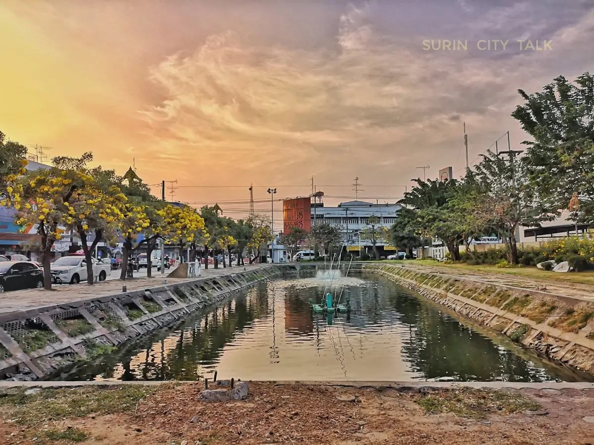
Surin City Wall and Moat is an important historical landscape in the heart of Surin Province. Located in Nai Mueang Subdistrict, Mueang Surin District, it preserves the traces of an ancient town through earthen ramparts, moats, embankments, and the historic layout of the old city. The site is known for its distinctive heart-like plan, 2 layers of earthen city walls, and parallel moats that once helped define and protect the ancient settlement. Today, parts of the area have been restored and improved by Surin Municipality as a public park, green space, recreation area, and exercise route for local residents. This makes the Surin City Wall And Moat a living historical site, where the memory of the old city remains connected with daily life in modern Surin.
The Surin City Wall And Moat should be understood first as an urban landscape rather than as a single monument. It does not appear as one isolated building, temple, or statue. Instead, it survives as a broad system of land, water, earthwork, and settlement pattern surrounding the old town area. The moats and earthen embankments reveal how people in the past chose a site, organized water, defined boundaries, and protected the community. Visiting this place is therefore a way to read history through real geography. The story of the site is found in the landform, water lines, roads, temples, neighborhoods, and public spaces that still shape Surin town today.
According to heritage records, the Surin City Wall And Moat was an ancient town with 2 layers of earthen walls and moats running parallel to them. The old city had a diameter of about 1,540 metres, a width of about 2,280 metres, and a length of about 1,540 metres, covering approximately 411 rai, 3 ngan, and 65 square wah. The outer moat was about 89 metres wide and 4,120 metres long, while the inner moat was about 55 metres wide and 8,640 metres long. The earthen embankment was about 20 metres wide and 8,640 metres long. These dimensions show that the site was not a minor settlement feature, but a large and organized ancient urban system.
The heart-like plan of the city wall and moat is one of the most memorable features of the site. Many ancient towns in Northeastern Thailand were surrounded by moats and earthen ramparts, but each town developed its own form according to landscape, water channels, soil conditions, expansion of settlement, and the needs of the community. The shape of Surin’s old town reflects a practical adaptation to local geography. It shows that ancient town planning was not only a matter of drawing straight lines, but also a process of working with the natural landform and the living conditions of the people.
The term “city wall” in the context of Surin does not refer to a high brick wall like those seen in some old capitals. Here, the wall was an earthen rampart created together with the excavation of the moats. Soil removed from the moat could be used to form embankments and defensive lines. This type of system was practical, efficient, and suitable for many ancient settlements in the region. The result was a combined defensive and water-management structure, where earth and water worked together to define and protect the town.
The Surin City Wall And Moat reflects the development of an ancient community with a high level of organization. Constructing large moats and earthen ramparts required labour, planning, coordination, and social structure. This indicates that Surin was not merely a loose cluster of small villages, but a place with urban importance in the past. The site also belongs to the wider cultural landscape of Southern Isan, a region rich in ancient communities and deeply connected with the cultural influence of the ancient Khmer world during an important period of regional history.
The connection between the Surin City Wall And Moat and ancient Khmer influence gives the site wider historical importance. Surin Province contains many Khmer archaeological sites, from small community sanctuaries to major temple groups near the Phanom Dong Rak mountain range. The city wall and moat in Surin town add another layer to this heritage. They show the history of settlement and urban organization, not only the history of religious monuments. When considered together with Khmer sanctuaries and other archaeological sites in the province, the city wall and moat help reveal Surin as a long-standing cultural landscape of settlement, movement, production, religion, and urban development.
The moat system was important for more than defence. Water was central to the life of an ancient town. The moat helped retain moisture, provide a water source, mark the town boundary, receive runoff during the rainy season, and create a buffer between the settlement and surrounding areas. The presence of 2 moat layers shows that water management was a major part of urban planning. The Surin City Wall And Moat is therefore not only evidence of protection, but also evidence of environmental knowledge and the ability to organize water within an ancient town.
Although some parts of the moat have become shallow and some areas have been affected by modern urban growth, the remaining lines of the moat and earthen embankment still allow visitors to understand the old town plan. Parts of the former landscape have become roads, neighborhoods, green spaces, and public parks. These changes show that a city is never frozen in time. It grows, shifts, and adapts. What matters is that the surviving traces continue to help modern residents and visitors recognize that Surin has a deeper urban history beneath the present city.
The role of Surin Municipality in improving the city wall and moat area has helped reconnect the historic landscape with everyday urban life. Clearing weeds, trimming trees, improving lighting, and developing the area as a public park and exercise space allow the historic moat to become useful again. This type of conservation keeps history visible and active. The site becomes more than a line on a map or a heritage record. It becomes a place where people walk, rest, exercise, meet, and experience the old city through daily life.
The area near Wat Nong Bua Intersection and the improved moat park is one of the places where the relationship between the old city and modern urban use can be seen clearly. The area includes moat lines, public green space, roads, and nearby communities. Local people use it as a place for relaxation and exercise, while visitors can observe how the old town boundary remains present within the modern city. The continued improvement of the area confirms that the Surin City Wall And Moat is still an active public landscape rather than an abandoned historical trace.
A meaningful visit to the Surin City Wall And Moat works best as a walking route rather than a single stop. Visitors can begin near the Phraya Surin Phakdi Si Narong Changwang Monument at the southern entrance to the city, then continue toward sections of the old moat, Surin City Pillar Shrine, Wat Burapharam, and the old town area. This route helps visitors understand Surin through several connected layers: the ancient town boundary, the city founder, the spiritual center of the town, and the temple heritage that remains central to local life.
The Phraya Surin Phakdi Si Narong Changwang Monument is closely connected with the historical meaning of the old city. It stands at the southern entrance to Surin, in an area associated with the former inner city wall. The monument tells the story of the city founder, while the moat and earthen wall tell the story of the town’s physical structure. Together, they create a fuller understanding of Surin. One represents leadership and memory; the other represents land, water, boundary, and settlement.
Surin City Pillar Shrine is another important place near the city wall and moat area. The shrine represents the auspicious spiritual center of the town, while the moat and wall represent the old physical boundary of the settlement. When the two are visited together, they show that an ancient town was built from both material and spiritual elements. The wall and moat defined the town in physical space, while the city pillar gave it symbolic and sacred meaning. This relationship gives Surin’s old town route greater depth.
Wat Burapharam Royal Monastery is also part of the nearby historic city route. The temple is one of Surin’s most respected religious sites and houses Luang Pho Phra Chi, a sacred Buddha image revered by local people. Linking the city wall and moat with the City Pillar Shrine, the Phraya Surin Phakdi Monument, and Wat Burapharam allows visitors to experience Surin as an old town with historical, spiritual, civic, and living cultural dimensions within a compact area.
As an urban landscape, the Surin City Wall And Moat also functions as green space in the modern city. The presence of water, trees, open ground, and walking areas softens the urban environment and gives residents a place to rest close to home. When maintained with clean pathways, lighting, and public access, the old moat becomes a public park, an exercise route, and an outdoor classroom at the same time. It shows how historical conservation and modern quality of life can support each other.
The value of the site does not depend on monumental buildings or dramatic ruins. Its importance lies in the surviving lines of the landscape. Visitors need to observe the moat, the embankment, the level of the land, the curve of the old town plan, nearby streets, and the way communities grew around the former boundary. When seen in this way, the Surin City Wall And Moat reveals the hidden structure of the old town still embedded within the present urban fabric.
For travelers interested in the history of Southern Isan, the city wall and moat provide an excellent starting point before visiting Khmer sanctuaries in other districts. The site shows that Surin town itself has ancient urban roots. It is not only a convenient base for visiting temples and archaeological sites elsewhere in the province. Starting with the old town landscape helps visitors understand settlement history first, then continue to places such as Prasat Sikhoraphum, Prasat Ban Phluang, Prasat Phum Pon, or the Ta Muen Temple Group to see the religious and artistic heritage of the wider province.
For foreign travelers, the Surin City Wall And Moat offers a clear introduction to Surin as a historic town in Southern Isan. Surin is known for elephants, silk weaving, and Khmer temples, but the old moat and earthen wall show another essential layer of the province: urban settlement. Earthen ramparts and moats are easy to understand as ancient systems for defining a town, managing water, and protecting the community. Visiting this place gives international travelers a stronger foundation for understanding Surin before exploring the province’s cultural attractions.
The everyday use of the city wall and moat area shows a simple but meaningful form of heritage revival. A historic landscape does not always need to become a closed museum. It can remain a public space when properly cared for. People who walk, jog, rest, or gather along the moat may not be studying history every time, but regular use keeps the old town boundary visible in local life. This familiarity helps residents recognize the value of the site naturally.
Morning and late afternoon are the best times to visit. The light is softer, the weather is more comfortable, and the lines of the moat and green space are easier to observe. Some sections are close to roads and active neighborhoods, so visitors should walk carefully and remain in safe public areas. A slow walk reveals more than a quick stop. The site rewards attention to small details: water, earth, trees, road alignment, old boundaries, and the way the city has grown around them.
Important details to observe include the surviving moat line, the earthen embankment, the curve of the old town, the parts improved as public parkland, the inner and outer moat areas, and the relationship between the moat and nearby temples or civic spaces. These details help visitors understand that the moat was not simply a body of water. It was a planning tool, a boundary marker, a defensive line, and an environmental system for the old town.
The Surin City Wall And Moat is also suitable for documentary-style urban photography. Instead of looking only for a single landmark image, visitors can photograph the waterline, trees, pathways, local movement, old-town streets, and public activities along the moat. Morning images capture a quieter side of the city, while evening images show people using the public space for exercise and relaxation. These scenes communicate the living character of Surin’s heritage.
A visit can take from 30 minutes to several hours depending on the route. A short visit is enough for observing one accessible section and taking photographs. A deeper visit can connect the moat with the Phraya Surin Phakdi Monument, Surin City Pillar Shrine, Wat Burapharam, and other old-town sites. This extended route gives a fuller picture of Surin as a historic city rather than a collection of separate attractions.
The importance of the Surin City Wall And Moat does not come from perfect preservation. It comes from the ability of the remaining landscape to tell the story of the old town. Many cities have lost their moats and walls to roads, buildings, and expansion. Surin still retains visible evidence and heritage records that confirm the structure of the ancient town. Keeping this area as both a public space and a learning landscape gives the city long-term cultural value.
Conservation of the city wall and moat depends on both local authorities and the public. Because the site lies within an active urban area, daily care is important. Keeping the water clean, avoiding waste disposal, respecting the embankment, protecting trees, and using the public space responsibly all help preserve the historic landscape. The success of the place is not measured only by renovation, but by continued respect and meaningful use.
The surrounding area has the full convenience of Surin town, including restaurants, cafés, hotels, markets, the railway station, government offices, and other attractions. Travelers can stay in Nai Mueang and easily connect the city wall and moat with nearby places. Restaurants and cafés are located within a short distance, making the site easy to include in a half-day or full-day city route.
Overall, the Surin City Wall And Moat is one of the most meaningful historical landscapes in Surin Province. It preserves evidence of an ancient town with 2 earthen wall layers, parallel moats, a large settlement area, and a distinctive heart-like plan. It connects past and present through public use, green space, recreation, and historical memory. For visitors who want to understand Surin beyond elephants and Khmer temples, this site reveals the urban roots of the province and the long continuity of settlement in Southern Isan.
| Name | Surin City Wall And Moat |
| Location | Nai Mueang Subdistrict, Mueang Surin District, Surin Province |
| Address | Old Surin Town Area, Nai Mueang Subdistrict, Mueang Surin District, Surin 32000, Thailand |
| Coordinates | Latitude 14.8832719755, Longitude 103.478267103 |
| Highlights | An ancient town landscape with 2 earthen wall layers, parallel moats, and a heart-like plan. Parts of the area are now used as a public park and recreation space for Surin residents |
| History / Period | A surviving ancient town landscape connected with settlement development in Southern Isan and the wider cultural influence of the ancient Khmer world in the region |
| Distinctive Features | 2 layers of earthen city walls, 2 moat lines, an outer moat about 89 metres wide and 4,120 metres long, an inner moat about 55 metres wide and 8,640 metres long, and an earthen embankment about 20 metres wide and 8,640 metres long |
| Ancient Town Area | Approximately 411 rai, 3 ngan, and 65 square wah, with a width of about 2,280 metres and a length of about 1,540 metres |
| Historical Meaning | Evidence of ancient urban planning, town defence, water management, and the historical boundary of old Surin |
| Travel Information | Located in Surin town, with easy access from the Phraya Surin Phakdi Si Narong Changwang Monument, Surin City Pillar Shrine, Wat Burapharam, and Surin Railway Station |
| Current Status | Open to visitors and used as a public space. Some sections have been improved as parkland and exercise areas for local residents |
| Open Days | Daily |
| Opening Hours | 08.00 - 17.00 |
| Fees | No Admission Fee |
| Main Areas / Zones | 1. Outer moat line 2. Inner moat line 3. Ancient earthen wall and embankment 4. City Wall And Moat public park near Wat Nong Bua Intersection 5. Recreation and exercise areas along the moat 6. Old town route linked with the Phraya Surin Phakdi Monument, Surin City Pillar Shrine, and Wat Burapharam |
| Caretaker / Coordinating Agencies | Surin Municipality and the Local Natural And Cultural Environment Conservation Unit of Surin Province |
| Main Contact Number | Surin Municipality Tel. 044-511117, 044-511272 Local Natural And Cultural Environment Conservation Unit Of Surin Province Tel. 044-515227 Tourism Authority of Thailand, Surin Office Tel. 044-514447 |
| Visitor Note | Some sections are close to roads and urban neighborhoods. Visitors should walk in safe public areas, keep the moat clean, and avoid damaging the ancient earthen embankment |
| Part 2: Nearby Attractions, Restaurants, And Accommodations | The following options help travelers plan a route in Surin town. Distances are approximate road distances |
| Nearby Tourist Attractions | 1. Phraya Surin Phakdi Si Narong Changwang Monument, about 300 m 2. Surin City Pillar Shrine, about 700 m 3. Wat Burapharam Royal Monastery, about 900 m 4. Surin Railway Station, about 1.5 km 5. Surin National Museum, about 4.4 km, Tel. 044-513274 6. Ban Tha Sawang Silk Weaving Village, about 8.1 km |
| Nearby Restaurants | 1. For Foo Cafe On Lak Mueang Road, about 1 km, Tel. 089-426-9992 2. Craft Cafe, about 1.7 km, Tel. 095-605-4281 3. SATI Coffee Roaster, about 1.9 km, Tel. 085-567-7104 4. Lab Mahanakhon Surin On Lak Mueang Road, about 2 km, Tel. 095-571-6286 5. Seoul Bar - Cafe & Bistro Surin, about 2 km, Tel. 080-959-7942 6. Thong Tarin Hotel Restaurant, about 1.4 km, Tel. 044-514281, 044-514282, 044-514283 |
| Nearby Accommodations | 1. The Grace Residence, about 300 m, Tel. 044-512164, 095-605-9350 2. The Wood Surin, about 1.1 km, Tel. 063-023-7999 3. Thong Tarin Hotel, about 1.4 km, Tel. 044-514281, 085-300-8858 4. Maneerote Hotel, about 1.1 km, Tel. 044-514569 5. Surin Majestic Hotel, about 1.1 km, Tel. 044-713980 6. Seven Bee Boutique Hotel - Surin, about 2.1 km, Tel. 089-355-5777 |
Frequently Asked Questions (FAQ)
Q: Where is the Surin City Wall And Moat located?
A: The Surin City Wall And Moat is located in Nai Mueang Subdistrict, Mueang Surin District, Surin Province, within the old town area of modern Surin city.
Q: What are the opening days and hours?
A: The site is open daily from 08.00 to 17.00.
Q: Is there an admission fee?
A: There is no admission fee. Visitors can walk, rest, take photographs, and learn about the old city landscape free of charge.
Q: What is special about the Surin City Wall And Moat?
A: The site preserves an ancient town landscape with 2 earthen wall layers, parallel moats, and a distinctive heart-like plan. Parts of the area now function as public green space and recreation areas.
Q: Why is the city wall and moat important to Surin history?
A: It is evidence of ancient urban planning, town defence, water management, and the historical boundary of old Surin.
Q: Which sections are suitable for walking?
A: Accessible sections around the old town area, especially the moat park near Wat Nong Bua Intersection and the route linked with the Phraya Surin Phakdi Monument, Surin City Pillar Shrine, and Wat Burapharam, are suitable for walking and observing the old town landscape.
Q: What nearby attractions can be visited with the city wall and moat?
A: Nearby attractions include the Phraya Surin Phakdi Si Narong Changwang Monument, Surin City Pillar Shrine, Wat Burapharam, Surin Railway Station, Surin National Museum, and Ban Tha Sawang Silk Weaving Village.
Q: How should visitors behave at the Surin City Wall And Moat?
A: Visitors should walk in safe public areas, avoid littering, keep the moat clean, avoid damaging the earthen embankment, and respect the historical landscape.
 Category: ●Art, Culture and Heritage
 Group: ●Landmarks and Memorials
Last Update : 2 MonthAgo
 Last Update : 2 MonthAgo
 Click to Access the Navigation Map GPS
Surin City Wall and Moat Map
Recommend

 Historical Sites and Monuments(11)
Landmarks and Memorials(2)
Historical Sites and Monuments(11)
Landmarks and Memorials(2)
 Art, Craft Centres, Tradition(5)
 Museums(1)
 Places of Worship
 Temple(15)
 Other Sacred Sites(1)
 Suburban Living
 Village, Community(9)
 Local Market(1)
 Nature and Wildlife
 National Parks and Marine Reserves(2)
 Mountain (Doi)(2)
 Dam, Reservoir, Lake(6)
 Waterfalls(1)
 River, Canal(2)
 Other natural attractions(4)
 Entertainment and Agricultural
 Animal camps and shows(1)
 Farms, Parks and Ecotourism(2)
 Travel Articles, Recipes
 Travel Review, Food Review(1)


