
lovethailand home >Northeastern Travel Attractions >Roi Et Travel Attractions >Muang Suang >Nong Phue > Wat Ban Lao Hok
TL;DR: Wat Ban Lao Hok is located at Ban Lao Hok, Nong Phue Subdistrict, Mueang Suang District, Roi Et Province, open Daily, hours 08.00 – 17.00.
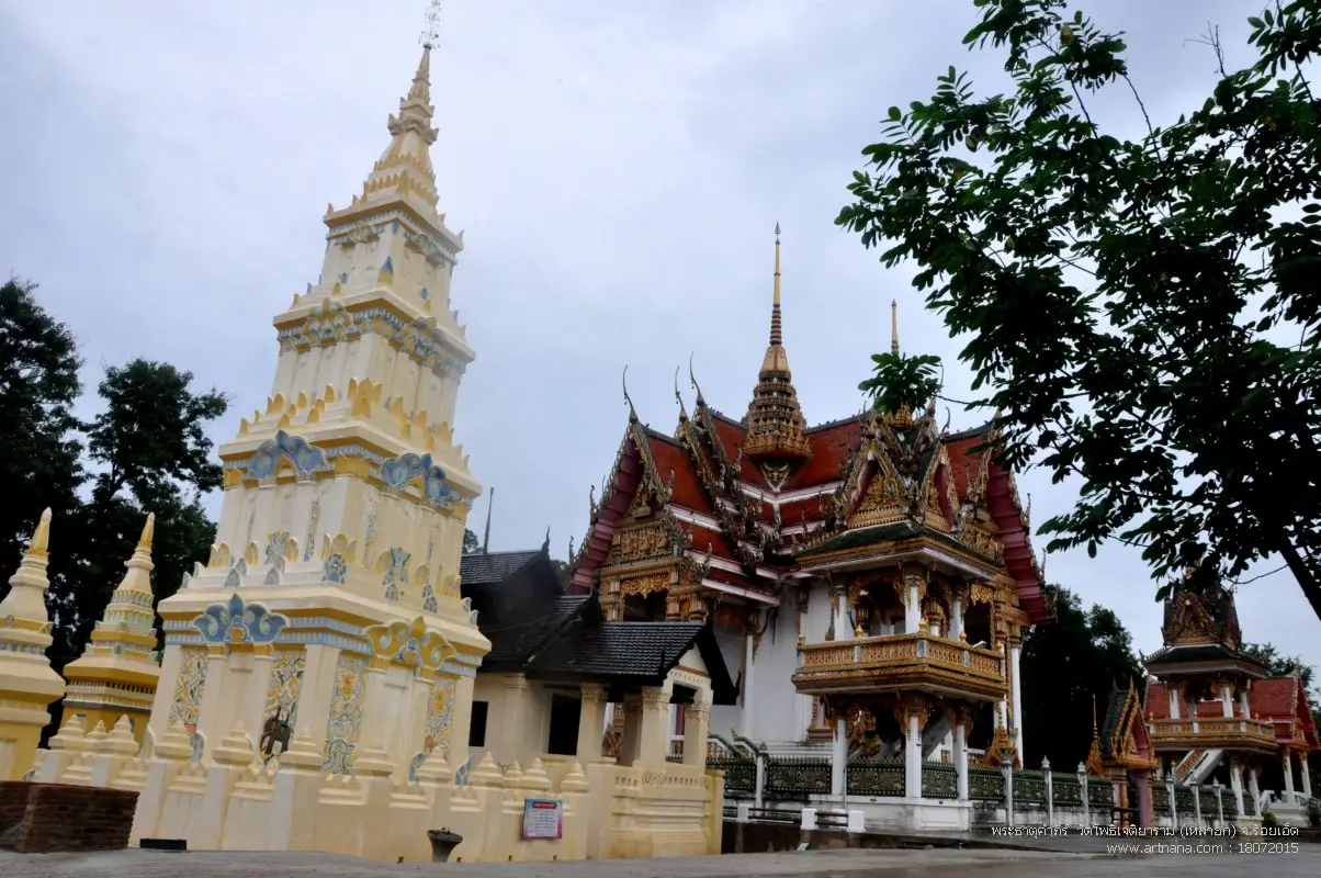
Wat Ban Lao Hok
Open Days: Daily
Opening Hours: 08.00 – 17.00
Wat Ban Lao Hok, also known as Wat Pho Chetiyaram in Roi Et Province, is a historic Buddhist monastery in Ban Lao Hok, Nong Phue Subdistrict, Mueang Suang District. It remains an active religious institution while preserving an old Isan ordination hall, locally called a sim, together with a distinctive square-based stupa decorated with extensive stucco reliefs. The village later constructed a larger modern ordination hall for contemporary ceremonies, but the earlier sim was retained as an important example of regional architecture and as a learning resource for future generations.
The monastery is known by several related names, including Wat Lao Hok, Wat Ban Lao Hok, Wat Pho Chetiyaram, and Phra That Lao Hok. Wat Lao Hok derives from the name of the surrounding village, while Pho Chetiyaram refers to a Buddhist monastery associated with a sacred chedi. The name Phra That Lao Hok appears in the historical temple register and indicates that the stupa has long been central to local religious identity. All of these names refer to the same monastery at Ban Lao Hok, Moo 4, Nong Phue Subdistrict, Mueang Suang District, Roi Et Province.
Wat Lao Hok remains open and active, with resident monks, Buddhist ceremonies, annual merit-making events, Kathin offerings, community memorial services, and religious education. Visitors can enter the temple grounds, make merit, worship the Buddha images, and view the old sim and stupa every day from 08.00 to 17.00 without paying an admission fee. Entry into the old sim requires coordination with a monk or temple caretaker because the historic building must be secured when it is not being used and its religious images and original architectural material require protection.
The historical temple register records that Wat Lao Hok was established in 1813 and was originally called Phra That Lao Hok. It received a royal grant of consecrated boundary in 1833, measuring 4 meters wide and 12 meters long. This period falls within the early Rattanakosin era, when Tai-Lao communities throughout northeastern Thailand were establishing village monasteries, ordination halls, stupas, and religious centers. A monastery served not only as a place for monastic ceremonies but also as a school, community meeting space, spiritual center, and repository of local knowledge.
Local historical accounts frequently state that the old sim was constructed in 1832, one year before the documented royal grant of consecrated boundary. The archaeological report does not identify an inscription giving the sim an exact construction date, so its age is also understood through architecture, building material, construction methods, and temple history. The surviving structure represents Isan religious architecture influenced by regional craftsmen and Vietnamese builders during the twenty-fourth and twenty-fifth Buddhist centuries. The year 1921, sometimes associated with restoration in popular accounts, is directly documented as the year in which construction of the principal stupa began. The stupa was completed in 1927.
Separating the histories of the monastery, the sim, and the stupa reveals a long sequence of development. The monastery was founded in 1813 and received its consecrated boundary in 1833. The old sim consequently belongs to the establishment of the Buddhist community during the early Rattanakosin period. The principal stupa was a later project constructed from 1921 to 1927, almost a century after the monastery was founded. Each structure represents the faith and resources of a different generation that contributed to the continuing development of Wat Lao Hok.
The village name Lao Hok reflects the language of settlement in northeastern Thailand. The word lao can refer to former woodland, scrubland, or an area cleared for habitation and cultivation. The temple took its identity from the village, demonstrating the close relationship between monastery and community. Residents contributed labor, material, funds, food, and maintenance. Wat Lao Hok is therefore not merely monastic property but a shared spiritual landscape containing the memories and collective work of Ban Lao Hok.
Mueang Suang District lies south of Roi Et city and forms part of a cultural landscape containing old settlements, moats, earthen mounds, archaeological remains, and historic monasteries. The district was connected with Suwannaphum, Chaturaphak Phiman, Kaset Wisai, and the Thung Kula Rong Hai plain. Monks, traders, craftsmen, and agricultural communities moved between these places, allowing architectural ideas to circulate widely. Wat Lao Hok consequently combines an Isan vernacular foundation with elements associated with Vietnamese builders who worked across northeastern Thailand.
The Isan term sim refers to a Buddhist ordination hall and derives from the concept of sima, the consecrated boundary within which monks perform formal acts of the Sangha. Village sims were usually much smaller than ordination halls at royal monasteries because they served limited numbers of monks and local residents. Brick, plaster, timber, and locally available roofing material were commonly used. Although modest in scale, a sim held high religious status and could receive carefully formed bases, porches, roof finials, brackets, gables, and sacred images.
The old sim at Wat Lao Hok is an enclosed rectangular brick-and-plaster building facing west. This orientation distinguishes it from many Thai temples whose principal entrances face east. Its projecting porch establishes a sheltered transition between the courtyard and the sacred interior. The porch reduces direct exposure of the wooden doorway to rain and sunlight while also providing a place for monks and worshippers to pause, remove footwear, arrange offerings, and prepare themselves before entering the consecrated space.
The sim measures approximately 3.90 meters in width, 6 meters in length, and 6.28 meters in height. Its plan is divided into three structural bays. The narrow, elongated room directs movement and attention toward the principal Buddha image at the far end. It was designed for a small monastic community rather than a large congregation. The dimensions preserve the intimate scale of a rural Isan sim, in which religious function and concentrated spiritual atmosphere were more important than monumental size.
The building stands on a raised molded lotus base composed of recessed and projecting horizontal profiles. This elevation protects the masonry from ground moisture and rain splash while separating the sacred floor from the ordinary courtyard. Strong horizontal lines visually stabilize the small building and balance the upward slope of its roof. The molded base demonstrates how local craftsmen combined practical climate response with architectural dignity.
The entrance porch projects approximately 3.30 meters from the main chamber. Its columns support the extended roof and carry lotus-petal stucco ornament at their bases and capitals. A low parapet surrounds the porch, defining its edge and protecting users from the raised platform. The porch is both a functional gathering space and an important architectural threshold between the public temple grounds and the more restricted interior.
Stairways rise to the porch from the northern and southern sides. Their paired arrangement creates visual balance and leaves the central front open toward the doorway. Visitors turn onto the porch before approaching the entrance, creating a gradual sequence rather than a direct movement from ground level into the sacred chamber. This controlled approach encourages slower movement and respectful behavior.
A single pair of wooden doors occupies the center of the western wall and opens outward. Three small windows appear on each side wall, admitting controlled light and ventilation without weakening the load-bearing masonry. The limited illumination creates a calm interior and emphasizes the Buddha image. Small openings also reduce direct rain and heat, making the structure appropriate for the climate of northeastern Thailand.
The interior has a polished cement floor and simple plastered walls supporting the timber roof. Decoration does not depend on expensive material. Proportion, light, shadow, and sacred images create the principal visual experience. This restraint is characteristic of a community-built sim, where collective religious purpose was more important than displaying political authority or wealth.
The roof is a gabled structure with a raised neck above the principal roof planes. Five wooden finials resembling regional ngo or chofa elements articulate the ridge and ends. These ornaments add rhythm and sacred meaning to an otherwise simple silhouette. At the time of archaeological documentation, the roof was covered with metal sheeting, while traces of cream and blue paint remained on parts of the structure. The different materials and colors record later phases of maintenance.
The relationship between masonry, plaster, timber, and roof ornament reflects a combination of Isan vernacular knowledge and Vietnamese building expertise. Vietnamese craftsmen were active in northeastern Thailand during the late nineteenth and early twentieth centuries and were valued for brick construction, plastering, arched forms, and stucco decoration. At Wat Lao Hok, their influence was adapted to the established form of a regional sim rather than replacing it.
The architecture has also been associated with Tai Yai or Kula cultural networks. Merchants and mobile communities carried more than commercial goods; they transmitted building techniques, religious ideas, and artistic preferences. The sim therefore provides physical evidence that rural Roi Et was connected with wider patterns of travel and cultural exchange across the Mekong region.
A principal Buddha image in the posture of subduing Mara stands on a lotus pedestal inside the sim. The seated figure reaches toward the earth, recalling the moment before enlightenment when the Buddha called the earth goddess to witness the merit accumulated throughout his previous lives. The image forms the visual and spiritual center of the room. The doorway, circulation axis, windows, and positions used by monks are all directed toward it.
An inscription records that Suphan and his family commissioned the principal Buddha image in 1961 and dedicated the merit to Thongbai and Kong. The image was made by a craftsman from Ban Samrong. This inscription identifies the donors, the purpose of the offering, and the connection between local communities. Commissioning a Buddha image in memory of relatives or benefactors allowed private merit to become a permanent religious resource shared by the entire village.
The hand gesture of the principal image differs in one detail from the most common form of the subduing-Mara posture. Instead of the right hand reaching toward the earth, observers have noted the use of the left hand. The variation may reflect a regional interpretation, a craftsman’s model, or a later intervention. It gives the image particular importance for the study of vernacular Buddhist iconography.
A wooden Buddha image in a Lao regional style is enshrined beside the principal figure. Wooden images were once common in village temples because timber was locally available and could be carved by community craftsmen. Such images are vulnerable to termites, insects, humidity, and temperature change. Their survival provides valuable evidence of devotional practice and artistic production outside major urban workshops.
The interior walls contain twelve low-relief stucco Buddha figures, each set within a triangular frame. The Buddhas are seated and shown with hands associated with teaching. Repetition creates a sacred rhythm across the wall without requiring a large mural program. The triangular frames emphasize each figure and echo the geometry of the roof above.
These stucco reliefs demonstrate how local craftsmen transformed simple material into sacred imagery. Changing daylight from the side windows produces shadows around the figures and frames, giving the walls visual depth. The plaster surfaces are fragile and must not be touched or cleaned by visitors, as pressure and abrasion can detach old material and remaining pigment.
The principal stupa stands north of the sim. Constructed from brick and plaster on a square plan measuring approximately 4.40 by 4.40 meters, it rises to about 16.30 meters. Four receding square tiers form the body before the structure transitions into its upper elements. The vertical stupa dominates the temple skyline and provides a strong contrast with the low horizontal form of the sim.
A red sandstone inscription shaped like a boundary marker records that construction began in 1921 and was completed in 1927. The six-year building period indicates continuing donations, labor, material procurement, and community organization. The inscription establishes that 1921 belongs directly to the history of the stupa rather than providing a confirmed restoration date for the sim.
The lowest tier is decorated with vegetation, worshipping deities, human figures, elephants, horses, tigers, rabbits, deer, kala faces, and mythological creatures. Some scenes show people riding elephants or horses. The animals carry symbolic associations but also reflect the natural and social world known to the local craftsmen. Elephants and horses represent power and travel, deer recall the Buddha’s first sermon, and kala functions as a guardian against destructive forces.
Scrolling foliage connects the figures and animals into a continuous composition. Leaves, stems, and flowers express fertility, growth, and the renewal of life. The designs do not follow the strict proportions of royal craftsmanship. Small differences between sides, irregular lines, and visible handwork give the monument its distinctive community character.
The second tier contains niches with meditating Buddhas and standing disciples holding flowers. The disciples express reverence and identify the stupa as a symbolic center of the Buddhist community. An eastern niche contains an unusual image of a Buddha seated on Garuda. Garuda, originally associated with Vishnu in Indian religion, is placed beneath the Buddha as a powerful supporting figure subordinated to Buddhist sacred authority.
The third tier depicts a standing Buddha in the posture of opening the worlds, accompanied by figures in a contemplative posture. The opening-the-worlds image refers to the Buddha’s descent from the Tavatimsa heaven after teaching his mother, when the realms of humans, gods, and beings in lower worlds became mutually visible. The adjacent contemplative figures express reflection and the compassionate decision to teach.
Two meditating Buddha figures appear on the fourth tier before the structure rises through a throne, small bell-shaped element, ringed spire, finial, and ceremonial umbrella. The progression from a heavy square base toward a narrow vertical crown directs the eye upward and symbolizes movement from the material world toward spiritual liberation.
Traces of red and blue pigment remain on the stupa, showing that its reliefs were once more extensively colored. Pigment helped separate Buddha figures, animals, deities, and foliage from the background. Each surviving layer can record a different phase of maintenance and must be studied before any repainting occurs. Applying modern impermeable paint without analysis could trap moisture and damage the historic plaster.
A low brick-and-plaster wall surrounds the stupa on a square plan of approximately 7 by 7 meters. The wall is about 1.20 meters high and has an eastern entrance. It establishes a sacred enclosure and protects the stupa base from ordinary circulation. Two smaller subsidiary stupas stand nearby, creating a formal group with a principal monument and secondary commemorative structures.
The temple layout changed as the community constructed a new ordination hall and reorganized access around the historic monuments. Such changes demonstrate that a living monastery evolves in response to religious and social requirements. Buildings acquire new functions, routes shift, and additional halls are introduced. Archaeological study makes it possible to identify these phases without treating the site as though it belonged to only one moment in history.
Archaeological work covered approximately 500 square meters around the sim and stupa. Excavation examined foundations, soil layers, former architectural features, surface levels, and evidence required for restoration. Archaeologists study not only visible walls but also buried traces of paths, building platforms, filling episodes, and earlier human activity. This information helps prevent restoration from destroying evidence below ground.
Conservation must prioritize original brick, plaster, timber, pigment, and construction evidence. The objective is structural stability and long-term survival rather than making every surface appear new. Replacement should be limited to material that has completely failed or creates a safety risk. New mortar and finishes must be compatible with old masonry because overly hard cement can trap moisture and cause historic brick to crack.
The roof requires regular inspection because a small leak can damage timber framing, plaster walls, Buddha images, and interior reliefs. Moisture increases the risk of termites, mold, biological growth, and salt crystallization. Drainage around the base must prevent standing water and erosion. Trees should be managed carefully so that dangerous roots and branches are controlled without removing the shade and landscape character of the monastery.
The modern ordination hall allows large ceremonies to take place without placing excessive pressure on the old sim. It provides more floor space, contemporary electrical services, ventilation, and easier access. The two buildings perform complementary roles: the new hall supports current monastic practice, while the old sim preserves historic craftsmanship, sacred images, and the physical scale of an earlier village community.
The old sim remains sacred even when it is not used for every formal monastic ceremony. Local residents continue to respect its Buddha images and religious history. Visitors must therefore treat it as a living place of worship rather than an ordinary museum exhibit. Shoes and hats should be removed, clothing should be modest, conversations should remain quiet, and religious images or architectural surfaces must not be touched.
The historical succession of abbots includes Phra Ma Phutthasaro, Phra Bo Piyadhammo, Phra Khanti Kalayano, Phra Hem Khemachitto, Phra Sonti Sirikutto, Phra Sutthi Sutthasilo, Phra Suwan Siriphatto, Phra Pramot Nakachoto, and Phra Samu Sila Aphinanto. Phra Khru Nanthawutthikon is also recorded as an important former abbot. The monastery is currently maintained by its resident Sangha together with the Ban Lao Hok community and relevant heritage authorities.
Managing a monastery containing historic architecture requires attention to monastic discipline, community use, safety, and conservation. Roof repair, electrical wiring, lighting, paving, drainage, and nearby construction can affect old material and views of the sim and stupa. The Sangha must balance these concerns with funerals, Kathin, robe offerings, meetings, education, and the everyday needs of residents.
Kathin remains an important annual activity at Wat Lao Hok. Held after the end of Buddhist Lent, the ceremony allows laypeople to present robes and donations to monks who have completed the rains retreat. Residents prepare food, clean the temple, receive visitors, and organize ceremonial spaces. Donations support monastic work and maintenance, while the event reconnects families who have moved away from the village.
Religious education continues to connect the monastery with the wider system of Buddhist study. Village temples historically taught reading, writing, Dhamma, local scripts, chanting, and social discipline. Although public schools now provide general education, Wat Lao Hok continues to offer a setting for moral instruction, community history, and the transmission of Buddhist practice.
Annual ceremonies associated with Makha Bucha, Visakha Bucha, Asalha Bucha, Buddhist Lent, the end of Lent, ancestral merit, Kathin, and Songkran keep the monastery active throughout the year. The old sim stands within a living ceremonial landscape rather than an isolated archaeological display. Different areas of the compound support chanting, food preparation, meetings, memorial services, and village gatherings.
A visit can begin in the principal courtyard, where the relationship among the old sim, stupa, modern ordination hall, and community buildings becomes clear. Stand at a moderate distance from the sim to observe its roofline, projecting porch, lotus base, and paired stairways. Walking around accessible sides reveals the small windows, masonry walls, and physical relationship between the sim and stupa.
When permission to enter the sim has been granted, remove footwear and headwear before climbing the stairs. Food and drinks should remain outside. Because the interior is narrow, small groups are more appropriate than large tour parties. Visitors can examine the principal Buddha, wooden image, twelve stucco reliefs, windows, and changing interior light without touching any material.
After leaving the sim, view the stupa from outside its low enclosure. Begin with the animals, figures, and vegetation on the lower level before following the niches upward. A camera zoom or small pair of binoculars allows details to be studied without climbing the wall or approaching fragile plaster. Oblique light provides stronger shadows and makes the reliefs easier to understand.
The compound can be understood through several zones: the historic sim, its interior image area, the principal stupa and subsidiary chedis, the modern ordination hall, the preaching and community halls, the monastic residential area, the ceremonial courtyard and parking zone, and the archaeological conservation area. Public spaces can be visited normally, while monks’ residences and working areas require permission.
The old sim is the most physically fragile zone. Visitors must not climb the base, sit on the porch parapet, write on walls, or lean bags against columns. Incense and candles should be used only at designated points away from old timber and plaster. Smoke, heat, and soot accelerate deterioration and create a fire risk.
The stupa enclosure is intended for respectful worship and controlled circulation. Do not climb the base, reach through damaged areas, or touch stucco figures. Offerings should be placed on designated stands rather than inserted into cracks. Moisture and pressure from inappropriate offerings can worsen structural damage.
The modern ordination hall is the principal setting for current monastic ceremonies and can accommodate larger groups. Comparing it with the old sim reveals changes in material, scale, ventilation, lighting, and community requirements. The old building expresses intimacy and vernacular knowledge, while the modern hall provides functional capacity for contemporary religious life.
The preaching hall and community courtyard support sermons, meetings, shared meals, and merit-making. During major events, cooking areas, seating, donation points, and ceremonial installations may occupy the grounds. Visitors should avoid obstructing these activities and should request permission before photographing individuals.
Facilities include parking, a multipurpose courtyard, shaded resting areas, and basic temple service buildings. The sim and stupa can be viewed from the level courtyard, but entry to the old sim requires stairs and is not wheelchair accessible. Older visitors can appreciate the exterior at close range without climbing the historic base.
Appropriate temple clothing covers shoulders and knees. Hats should be removed indoors, feet must not be pointed toward Buddha images, and visitors should avoid standing over seated monks. Historic structures and sacred images must not be used as props for disrespectful photographs.
Exterior photography is acceptable when it does not disturb monks or worshippers. A western view records the projecting porch, while a northwestern angle includes both the sim and stupa. Interior photography requires permission and flash should be avoided. Tripods must not stand on the historic base or obstruct stairs. Drone use requires temple authorization and compliance with Thai aviation law.
The period from 08.00 to 10.00 offers cooler conditions and relatively quiet temple activity. From approximately 15.00 to 17.00, western sunlight reaches the front of the sim and emphasizes the porch, columns, and molded base. Midday can be hot, particularly from March to May. Drinking water should be kept outside the historic buildings.
The cool season from November to February is suitable for combining several cultural attractions in Mueang Suang. The rainy season produces green agricultural landscapes but can leave stairs and ground surfaces slippery. The hot season coincides with Songkran and other community events. A weekday visit offers quieter architectural study, while a festival visit reveals the temple’s living social role.
Getting There from Roi Et city involves following Highway 215 south toward Mueang Suang District, then continuing into Nong Phue Subdistrict and Ban Lao Hok. The total road distance is approximately 30 kilometers and normally requires 35–45 minutes. The final section passes through village roads, where drivers should reduce speed and watch for motorcycles, agricultural vehicles, pedestrians, and animals.
The coordinates are approximately 15.825486, 103.721596. Online maps may list the destination as Wat Lao Hok, Wat Ban Lao Hok, or Wat Pho Chetiyaram. Confirm that the selected point is in Nong Phue Subdistrict, Mueang Suang District. Public transport users can travel to central Mueang Suang and arrange a local vehicle to the village. The fare and return time should be agreed in advance.
Wat Mueang Suang Yai, Phra That Chedi Si Mueang Suang, and the Thao Khattiyanam Monument lie approximately 2.5 kilometers away. Together they represent the principal religious and historical center of the district. Their larger scale provides a useful contrast with the intimate village sim at Wat Lao Hok.
Ku Mueang Suang at Wat Mueang Suang Kao lies approximately 3.5 kilometers from the temple. Its brick and laterite remains preserve evidence of an older settlement landscape. Wat Tha Sawang in Nong Phue Subdistrict is approximately 5 kilometers away and can be included in the same local cultural route.
Wang I Phui Phonthep Bridge is approximately 12 kilometers away and provides a rural viewpoint, particularly in the late afternoon. Travelers interested in Isan ordination halls can continue approximately 22 kilometers to Wat Traiphum Khanachan in Suwannaphum District, where an old sim, murals, and regional religious art provide further comparison.
The nearest dining option is Heng Heng Mookata Mueang Suang in Ban Lao Hok, approximately 1.5 kilometers away. Other restaurants and cafes in central Mueang Suang include Mueang Suang Cafe, Salayte Hashery, Café Amazon, Scottish Cafe, and Krua Kru Aen. These establishments are approximately 3–7 kilometers from the temple and provide Thai food, individual dishes, coffee, and refreshments.
Nearby accommodation includes Pieng Din Resort, approximately 3 kilometers away, and Coffee & Homestay 568, approximately 4–5 kilometers away. Additional options are available in Chaturaphak Phiman and Roi Et city, including Im Em Resort and 101 Hotel. Staying in Mueang Suang is convenient for an early temple visit and a cultural route through surrounding districts.
A half-day itinerary can begin at Wat Lao Hok in the morning, allowing one to two hours for the sim, stupa, and modern ordination hall. Continue to Wat Mueang Suang Yai, the Thao Khattiyanam Monument, and Ku Mueang Suang before having lunch in the district center. The route is compact and combines religion, architecture, and local history without requiring long drives.
A full-day route can continue to Wat Traiphum Khanachan, Wat Sa Ket, or Ku Phra Kona in Suwannaphum District. Wat Lao Hok represents an early Rattanakosin sim and twentieth-century community stupa. Wat Traiphum Khanachan preserves murals and local Buddha images, Wat Sa Ket is known for its paired sims, and Ku Phra Kona represents ancient Khmer architecture. Together they demonstrate centuries of cultural development in Roi Et.
Wat Lao Hok is a valuable architectural classroom. Its raised base limits moisture, extended eaves reduce sun and rain, small windows control light, the porch creates a transitional space, and the brick walls support the roof. Each element responds simultaneously to climate, construction resources, and religious practice.
For art history, the sim and stupa demonstrate interaction among Isan, Lao, Vietnamese, Tai Yai, and Kula cultural networks. Craftsmen adapted remembered models to local material, budgets, and religious expectations. The result is not a copy of a single external style but a distinctive regional synthesis.
In Buddhist spatial organization, the sim, Buddha images, and stupa perform complementary functions. The sim supports formal monastic acts, the images provide a focus for worship and teaching, and the stupa symbolizes sacred remains, memory, and the continuity of the religion. Together they integrate monastic practice, lay devotion, and merit dedicated to ancestors.
Socially, the temple records the work of many generations. Establishment of the monastery, consecration of its boundary, construction of the sim and stupa, dedication of Buddha images, building of the modern ordination hall, and preservation of older structures all required community labor and donations. History at Wat Lao Hok belongs not only to rulers or renowned monks but also to village craftsmen, farming families, donors, and ordinary worshippers.
Preserving the old sim after constructing a modern hall was a significant community decision. Many earlier village buildings elsewhere were demolished, abandoned, or reused as building material. At Ban Lao Hok, the historic sim was retained so that its actual scale, masonry, plaster, timber, images, and craftsmanship could be studied directly rather than known only through photographs.
Threats include rain, humidity, termites, mold, vibration, physical contact, incompatible repair material, and insensitive nearby construction. Increased visitor numbers can also place pressure on stairs, floors, and plaster. Conservation must therefore address the building, its landscape, and the behavior of everyone using the site.
Visitors assist preservation by avoiding contact, climbing, writing, moving objects, and bringing food into the sim. Damage should be reported to monks or caretakers rather than repaired independently. Donations can support temple maintenance, but intervention involving historic material requires qualified conservation practice.
The importance of Wat Lao Hok does not depend on monumental size. Its small sim preserves climate-responsive building knowledge, its Buddha images record personal and community devotion, its stupa contains a complex world of Buddhist figures, animals, and vegetation, and its modern ordination hall demonstrates continuing religious life. The ensemble is living heritage rather than an isolated collection of old objects.
A visit reveals how local history can be read through brickwork, plaster, windows, inscriptions, sacred images, and spatial relationships. Wat Lao Hok connects the establishment of an early Rattanakosin village, Isan religious architecture, Vietnamese craftsmanship, Kula cultural networks, community stupa building, and modern heritage conservation within one compound.
Wat Ban Lao Hok is particularly rewarding for travelers interested in historic temples of Roi Et, Isan sims, vernacular stupas, stucco relief, Vietnamese-influenced architecture, and the history of Mueang Suang. Respectful visitation protects the monastery’s religious atmosphere and supports continued appreciation of the heritage maintained by the Ban Lao Hok community.
| Name | Wat Ban Lao Hok, Also Known as Wat Pho Chetiyaram |
| Alternative Names | Wat Lao Hok, Wat Ban Lao Hok, Wat Pho Chetiyaram, and Phra That Lao Hok |
| Location | Ban Lao Hok, Nong Phue Subdistrict, Mueang Suang District, Roi Et Province |
| Address | Moo 4, Ban Lao Hok, Nong Phue, Mueang Suang, Roi Et 45220, Thailand |
| Coordinates | 15.825486, 103.721596 |
| Current Status | An Active Buddhist Monastery with Resident Monks, Religious Activities, and Public Access to the Temple Grounds |
| Open Days | Daily |
| Opening Hours | 08.00 – 17.00 |
| Admission Fee | Free Admission; Voluntary Temple Donations Are Welcome |
| Site Caretakers | The Resident Sangha, Ban Lao Hok Community, and Relevant Heritage Conservation Authorities |
| Recorded Former Abbot | Phra Khru Nanthawutthikon |
| Monastic Order | Mahanikaya |
| Temple Foundation | Established in 1813 and Originally Known as Phra That Lao Hok |
| Consecrated Boundary | Granted in 1833; the Boundary Measures 4 × 12 Meters |
| Local Construction Date for the Sim | 1832, during the Early Rattanakosin Period |
| Sim Architecture | An Enclosed Rectangular Brick-and-Plaster Sim Facing West, with a Projecting Porch and Raised Molded Lotus Base |
| Sim Dimensions | Approximately 3.90 Meters Wide, 6 Meters Long, and 6.28 Meters High; the Porch Projects Approximately 3.30 Meters |
| Artistic Influences | Isan Vernacular Architecture Combined with Vietnamese Craftsmanship and Elements Associated with Tai Yai or Kula Networks |
| Important Buddha Images | A Principal Subduing-Mara Buddha Dedicated in 1961, a Lao-Style Wooden Buddha, and Twelve Low-Relief Stucco Buddhas |
| Principal Stupa | A Square Brick-and-Plaster Stupa Measuring Approximately 4.40 × 4.40 Meters and Rising Approximately 16.30 Meters through Four Receding Tiers |
| Stupa Construction | Construction Began in 1921 and Was Completed in 1927, as Recorded on a Red Sandstone Inscription |
| Stupa Decoration | Vegetation, Worshipping Deities, Elephants, Horses, Tigers, Rabbits, Deer, Kala, Mythical Creatures, Buddha Images, and Standing Disciples |
| Archaeological Study | Approximately 500 Square Meters around the Sim and Stupa Were Investigated to Study Foundations, Construction Phases, and Conservation Requirements |
| Main Areas and Zones | 1. Historic Sim 2. Interior Buddha and Stucco Relief Zone 3. Principal Stupa 4. Subsidiary Chedis and Sacred Enclosure 5. Modern Ordination Hall 6. Preaching and Community Halls 7. Monastic Residential Area 8. Ceremonial Courtyard and Parking Area 9. Archaeological Conservation Zone |
| Facilities | Parking, a Multipurpose Courtyard, Shaded Resting Areas, and Basic Temple Service Buildings |
| Visitor Etiquette | Dress Modestly, Remove Shoes before Entering the Sim, Do Not Touch Stucco or Buddha Images, Do Not Climb Historic Bases, and Request Permission before Interior Photography |
| Getting There | Follow Highway 215 South from Roi Et City toward Mueang Suang, then Continue to Nong Phue Subdistrict and Ban Lao Hok; the Total Distance Is Approximately 30 km |
| Local Information | Mueang Suang Subdistrict Municipality, Tel. 043-597-069; Mueang Suang District Office, Tel. 043-597-071 Ext. 2 |
| Nearby Tourist Attractions | 1. Wat Mueang Suang Yai and Phra That Chedi Si Mueang Suang, Approximately 2.5 km, Local Information Tel. 043-597-069 2. Thao Khattiyanam Monument, Approximately 2.5 km, Local Information Tel. 043-597-069 3. Ku Mueang Suang at Wat Mueang Suang Kao, Approximately 3.5 km, Local Information Tel. 043-597-069 4. Wat Tha Sawang, Nong Phue Subdistrict, Approximately 5 km 5. Wang I Phui Phonthep Bridge, Approximately 12 km, Tourism Information Tel. 043-597-071 Ext. 2 6. Wat Traiphum Khanachan, Suwannaphum District, Approximately 22 km 7. Ku Phra Kona, Suwannaphum District, Approximately 36 km |
| Nearby Restaurants | 1. Heng Heng Mookata Mueang Suang, Approximately 1.5 km, Tel. 062-671-0754 2. Mueang Suang Cafe, Approximately 3 km, Tel. 063-727-9449 3. Salayte Hashery, Approximately 4 km, Tel. 043-030-088, 065-242-8188 4. Café Amazon DD2717 Mueang Suang, Approximately 4 km, Tel. 088-551-3356 5. Scottish Cafe, Approximately 6 km, Tel. 088-562-4390 6. Krua Kru Aen, Approximately 7 km, Tel. 096-494-4245 |
| Nearby Accommodations | 1. Pieng Din Resort, Approximately 3 km, Tel. 087-218-5669 2. Coffee & Homestay 568 Branch 2, Approximately 4 km, Tel. 093-584-7998 3. Coffee Homestay 568, Approximately 5 km, Tel. 064-247-3645 4. Im Em Resort, Chaturaphak Phiman District, Approximately 20 km, Tel. 085-057-5754 5. 101 Hotel, Roi Et City, Approximately 30 km, Tel. 043-513-999, 065-119-6999 |
Frequently Asked Questions (FAQ)
Q: Is Wat Ban Lao Hok currently open?
A: Yes. The monastery remains active, has resident monks, and is open to visitors daily from 08.00 to 17.00.
Q: Is there an admission fee?
A: Admission is free. Visitors may make a voluntary donation toward temple and heritage maintenance.
Q: When was the old sim built?
A: Local historical information dates the sim to 1832. The temple register records that the monastery was established in 1813 and received its consecrated boundary in 1833.
Q: Does 1921 refer to restoration of the sim or construction of the stupa?
A: The sandstone inscription identifies 1921 as the year construction of the principal stupa began. The stupa was completed in 1927. Conservation of the sim belongs to a separate history of maintenance.
Q: What are the main architectural features of the sim?
A: It is an enclosed west-facing brick-and-plaster sim with a raised lotus base, projecting porch, northern and southern stairways, three windows on each side, and a combination of Isan and Vietnamese craftsmanship.
Q: What important objects are kept inside the sim?
A: The interior contains a principal subduing-Mara Buddha dedicated in 1961, a Lao-style wooden Buddha, and twelve low-relief stucco Buddha figures in triangular frames.
Q: What is distinctive about the Phra That Lao Hok stupa?
A: The stupa rises approximately 16.30 meters through four square tiers and is decorated with Buddhas, disciples, worshipping deities, human figures, animals, mythical creatures, and scrolling vegetation, together with traces of red and blue pigment.
Q: How can travelers reach Wat Lao Hok from Roi Et city?
A: Follow Highway 215 south toward Mueang Suang District, then continue to Nong Phue Subdistrict and Ban Lao Hok. The total road distance is approximately 30 km and the journey normally takes 35–45 minutes.
 Category: ●Places of Worship
 Group: ●Temple
Last Update : 4 WeekAgo
 Last Update : 4 WeekAgo
 Click to Access the Navigation Map GPS
Wat Ban Lao Hok Map
Recommend

 Art, Culture and Heritage
 Historical Sites and Monuments(3)
 Landmarks and Memorials(5)
 Art, Craft Centres, Tradition(2)
 Museums(1)
 Educational Places
 Educational Gardens, Farm(3)
Temple(35)
Educational Gardens, Farm(3)
Temple(35)
 Other Sacred Sites(6)
 Suburban Living
 Village, Community(1)
 Local Market(1)
 Nature and Wildlife
 National Parks and Marine Reserves(1)
 Mountain (Doi)(2)
 Dam, Reservoir, Lake(8)
 Waterfalls(1)
 Flower Field(1)
 River, Canal(4)
 Entertainment and Agricultural
 Zoos and Aquariums(1)
 Stadium(1)
 Farms, Parks and Ecotourism(5)
 Shopping
 Shopping and Night Market(1)


