
lovethailand home >North Travel Attractions >Uttaradit Travel Attractions >Mueang Uttaradit >Pa Sao > Bueng Kalo
TL;DR: Bueng Kalo is located at Pa Sao Subdistrict and partly Khung Taphao Subdistrict, Mueang Uttaradit District, Uttaradit Province, open Open Daily, hours Morning To Evening Is Recommended.
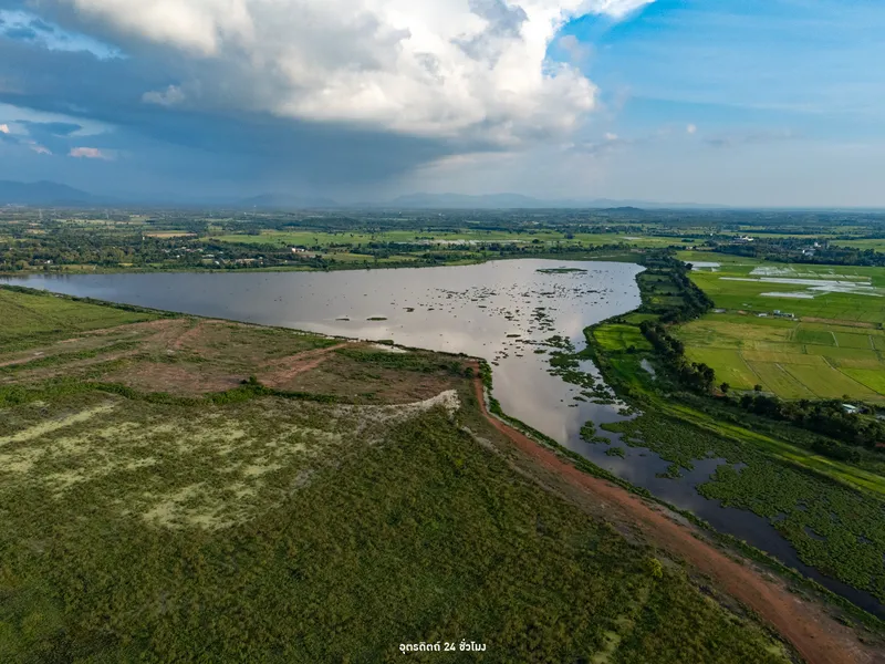
Bueng Kalo
Open Days: Open Daily
Opening Hours: Morning To Evening Is Recommended
Bueng Kalo, also known as Bueng Thung Kalo, is one of the largest and most important water-retention areas in Uttaradit Province. It is located mainly in Pa Sao Subdistrict and extends partly into Khung Taphao Subdistrict, Mueang Uttaradit District. The wetland lies about 2 km from National Highway 11 and covers approximately 7,500 rai. More than a large body of water, Bueng Kalo is a significant natural landscape connected to agriculture, local water management, wetland ecology, community beliefs, local history, and the long-term development of education, religion, recreation, and public space in Uttaradit.
Geographically, Bueng Kalo is closely linked to the Nan River system, the main river of Uttaradit and much of lower northern Thailand. During the rainy season, rising water from the Nan River can enter the wetland area, allowing the lake to function as a natural water-retention zone. This helps reduce flood pressure in nearby communities and agricultural land. During the dry season, stored water supports agriculture and daily use. For this reason, Bueng Kalo plays an important role as a natural reservoir, wetland ecosystem, and water-management buffer for Mueang Uttaradit District.
The area of about 7,500 rai gives Bueng Kalo a broad open landscape. Visitors can see water surfaces, wetland plants, reeds, embankments, local roads, and wide sky views. The atmosphere is very different from dense urban attractions. It feels open, quiet, and closely connected to seasonal nature. During the high-water season, the lake appears broad and reflective, while during the lower-water period, reeds and wetland vegetation become more visible. This seasonal change is one of the site’s main charms.
Bueng Kalo is also a notable birdwatching area in Uttaradit. Large wetlands provide habitat, food sources, and resting areas for resident waterbirds and seasonal migratory birds. Birdwatchers may observe birds around reeds, wetland edges, open water, embankments, and shallow areas. Bird diversity changes according to water levels, season, and habitat condition. Morning and late afternoon are generally the best times to visit because the light is softer, temperatures are lower, and birds are more active.
Environmentally, Bueng Kalo is an important example of a multifunctional wetland. Wetlands do not only store water. They help trap sediment, slow water movement, support fish and aquatic life, provide habitat for plants and animals, and maintain ecological balance near urban and agricultural areas. Preserving Bueng Kalo is therefore important for water security, biodiversity, and the quality of life of nearby communities.
Local legends give Bueng Kalo another layer of meaning. Communities around the lake, including areas near Khung Taphao and Huai Bong, have long told stories that the site may once have been an ancient city that later collapsed and became a lake. Although such stories belong to local oral tradition, they reflect the deep relationship between community memory and the landscape. The legend of the sunken city makes Bueng Kalo more than a natural reservoir; it becomes a place of mystery, imagination, and cultural memory.
Interest in this legend increased in June 2010, when the lake dried out and villagers burned dense reeds and aquatic vegetation, revealing remains of structures and ancient objects. This event brought renewed attention to the old stories about Bueng Kalo. While historical interpretation requires careful archaeological study, the discovery made the lake important as a place where physical traces of the past may still be hidden beneath water, sediment, and wetland vegetation.
On the southern side of Bueng Kalo stands the Chao Pho Kalo Shrine, a respected local spiritual site. Local people believe Chao Pho Kalo protects the area around the lake. The shrine represents the spiritual relationship between the community and the wetland. Visitors should behave respectfully, keep noise low, avoid littering, and treat the shrine and surrounding area with care.
Bueng Kalo has also played a role in provincial development planning. Because it is a large area located close to major transportation routes and Uttaradit city, it has been considered for development as an educational, sports, and recreational park. Past development efforts included canal dredging, road connections from Highway 11, and public facilities such as an OTOP center. Although some facilities are no longer active, they show the long-term attempt to connect the wetland with public recreation and local development.
Today, the surrounding area includes several important institutions and public landmarks, such as Uttaradit Rajabhat University’s Lam Rang Thung Kalo Campus, Boromarajonani College of Nursing Uttaradit, the Princess Srinagarindra monument, and the Uttaradit Buddhist Park. These places make Bueng Kalo more than a natural water area. It has become a strategic landscape linking education, healthcare, religion, culture, public memory, and community life.
Uttaradit Rajabhat University’s Lam Rang Thung Kalo Campus is especially important to the area. The presence of an educational institution gives Bueng Kalo potential as a living classroom for wetland ecology, water management, community development, and local history. Students, researchers, and local residents can use the area to study real environmental and social systems. This gives the wetland value beyond tourism alone.
The Uttaradit Buddhist Park and the Princess Srinagarindra monument add religious and public-memory dimensions to the landscape. Visitors can combine nature observation at the lake with visits to nearby cultural and religious sites. This type of route is suitable for travelers who prefer quiet, meaningful travel rather than fast-paced sightseeing.
Bueng Kalo is suitable for driving, walking, birdwatching, photography, cycling, and relaxing in a wide open landscape. Different access points provide different perspectives of the lake. Some areas are good for sunrise or soft morning light, while others are better for wide-sky views, reflections, wetland plants, and bird observation. Photographers should consider visiting in the morning or late afternoon when the light is softer and the weather is more comfortable.
Birdwatchers should bring binoculars, a camera with a long lens, a hat, water, and neutral-colored clothing. The best birdwatching behavior is quiet observation from a respectful distance. Visitors should not chase birds, make loud sounds, or use calls that disturb natural behavior. Wetland habitats are sensitive, and responsible birdwatching helps protect wildlife.
Bueng Kalo is also a useful place to learn about water and community life. Visitors can see how a wetland supports floodwater retention, dry-season water use, agriculture, aquatic life, bird habitat, and public open space. This relationship makes the lake a valuable example of how natural systems support both communities and ecosystems.
Responsible travel is essential. Visitors should not throw trash into the lake or along the road, should not disturb birds or aquatic animals, should not burn vegetation, and should not enter sensitive bird habitat areas. Litter, noise, and careless activity can directly harm wetland quality and wildlife.
During the rainy season, Bueng Kalo has more water and clearly performs its role as a natural retention area. Some roads or edges may be wet, muddy, or covered with shallow water. During the dry season, more reeds and wetland vegetation may be visible, making it a good time to observe the landform and reflect on local history. However, visitors should avoid lighting fires or entering areas with dry vegetation.
Access to Bueng Kalo is relatively convenient because the wetland is only about 2 km from Highway 11 and not far from Uttaradit city. Visitors can travel by private car, motorcycle, or bicycle when the weather is suitable. Main access routes include the side near Uttaradit Rajabhat University’s Lam Rang Thung Kalo Campus and the side near Wat Thung Setthi in Ban Huai Bong.
Getting There from Uttaradit city is straightforward. Travel toward Pa Sao Subdistrict near National Highway 11, then turn into the Bueng Kalo area about 2 km from the highway. Visitors heading to the university side can follow signs toward Uttaradit Rajabhat University’s Lam Rang Thung Kalo Campus. Those who want to visit the community and temple side can use the route toward Wat Thung Setthi in Ban Huai Bong. Road conditions should be checked during the rainy season and high-water periods.
The main local contact is Pa Sao Subdistrict Municipality, as Bueng Kalo lies mainly in Pa Sao Subdistrict and partly in Khung Taphao Subdistrict. Visitors who need current access information, local activity updates, or area conditions should contact the municipality during working hours.
Overall, Bueng Kalo is more than a quiet wetland. It combines nature, water management, birds, local legends, the Chao Pho Kalo Shrine, education, religion, and public space in one large landscape. Its beauty is not dramatic but broad, calm, and layered with meaning. Visitors who take time to understand the place will see how strongly this wetland reflects the relationship between Uttaradit people, water, nature, and community memory.
| Name | Bueng Kalo / Bueng Thung Kalo |
| Location | Pa Sao Subdistrict and partly Khung Taphao Subdistrict, Mueang Uttaradit District, Uttaradit Province |
| Address | Public land area in Pa Sao Subdistrict, extending partly into Khung Taphao Subdistrict, Mueang Uttaradit District, Uttaradit 53000, Thailand |
| Coordinates | 17.60417, 100.15722 |
| Area Size | Approximately 7,500 rai |
| Highlights | Large wetland and water-retention area of Uttaradit, important for agriculture, water management, ecology, and birdwatching |
| Distinctive Features | Located about 2 km from National Highway 11, with wide open wetland scenery suitable for birdwatching, photography, cycling, and scenic driving |
| Natural Importance | Natural water-retention area linked to the Nan River system and habitat for resident and migratory waterbirds |
| Historical And Cultural Importance | Associated with the local sunken-city legend, ancient remains found in 2010, and the Chao Pho Kalo Shrine on the southern side of the lake |
| Main Areas / Nearby Landmarks | Uttaradit Rajabhat University Lam Rang Thung Kalo Campus, Boromarajonani College of Nursing Uttaradit, Princess Srinagarindra Monument, Uttaradit Buddhist Park, and Wat Thung Setthi |
| Travel Information | From Uttaradit city, travel toward Pa Sao Subdistrict near National Highway 11, then enter the lake area about 2 km from the highway via the university side or the Wat Thung Setthi / Ban Huai Bong side |
| Current Status | Public land, agricultural water-retention area, and important wetland landscape of Uttaradit Province |
| Open Days | Open daily |
| Opening Hours | Morning to evening is recommended |
| Recommended Activities | Birdwatching, photography, scenic driving, cycling, wetland learning, visiting Chao Pho Kalo Shrine, and exploring nearby public landmarks |
| Caretaker / Contact Authority | Pa Sao Subdistrict Municipality |
| Main Contact Number | 055-817771 |
| Official Website / Official Page | www.pasaouttaradit.go.th / Pa Sao Subdistrict Municipality |
| Nearby Tourist Attractions | 1. Chao Pho Kalo Shrine, about 1 km 2. Uttaradit Rajabhat University Lam Rang Thung Kalo Campus, about 2 km 3. Wat Thung Setthi / Wat Huai Bong, about 3 km 4. Uttaradit Buddhist Park, about 4 km 5. Princess Srinagarindra Monument, about 4 km 6. Uttaradit City Center, about 8 km |
| Nearby Restaurants | 1. Local Food Shops In Ban Huai Bong, Pa Sao Subdistrict, about 3 km 2. Krua Ahan Pa Mae Chaliao, Si Chao Wang Soi 36, Ban Pa Sao, about 5 km, Tel. 095-387-4429, 095-436-4852 3. Lom Yen Restaurant, Highway 11, Pa Sao Subdistrict, about 6 km 4. Food Shops Around Uttaradit Rajabhat University / Thung Kalo, about 2 km 5. Restaurants In Uttaradit City Center, about 8 km |
| Nearby Accommodations | 1. Daily Rooms / Dormitory-Style Stays Near Uttaradit Rajabhat University, about 5 km 2. Baan Phu Jad Kan Resort, about 7 km 3. Sunee Boutique Hotel, about 8 km 4. K2 Living Hotel Uttaradit, about 8 km, Tel. 055-411548, 090-243-4468 5. Seeharaj Hotel Uttaradit, about 9 km, Tel. 055-832790 6. Friday Hotel Uttaradit, about 9 km, Tel. 055-832775-9 |
Frequently Asked Questions (FAQ)
Q: Where is Bueng Kalo located?
A: Bueng Kalo, or Bueng Thung Kalo, is located mainly in Pa Sao Subdistrict and partly in Khung Taphao Subdistrict, Mueang Uttaradit District, Uttaradit Province.
Q: How large is Bueng Kalo?
A: Bueng Kalo covers approximately 7,500 rai and is one of the major water-retention areas of Uttaradit Province.
Q: What activities are suitable at Bueng Kalo?
A: Suitable activities include birdwatching, photography, scenic driving, cycling, wetland learning, and visiting nearby public landmarks.
Q: How is Bueng Kalo connected to the Nan River?
A: Bueng Kalo is linked to the Nan River water system and helps retain water during the rainy season while supporting water use during the dry season.
Q: Is there a sunken-city legend at Bueng Kalo?
A: Yes. Local communities have long told stories of a sunken city, and ancient remains were found in 2010 when the lake dried out.
Q: Which route should visitors use to enter Bueng Kalo?
A: Visitors can enter from the Uttaradit Rajabhat University Lam Rang Thung Kalo Campus side or from the Wat Thung Setthi / Ban Huai Bong side. The lake is about 2 km from National Highway 11.
Q: When is the best time for birdwatching at Bueng Kalo?
A: Morning and late afternoon are best because the weather is cooler, the light is softer, and birds are more likely to be active in the wetland.
Q: Who can visitors contact for local information?
A: Visitors can contact Pa Sao Subdistrict Municipality at 055-817771.
 Category: ●Nature and Wildlife
 Group: ●River, Canal
Last Update : 4 MonthAgo
 Last Update : 4 MonthAgo
 Click to Access the Navigation Map GPS
 Art, Culture and Heritage
 Historical Sites and Monuments(2)
 Landmarks and Memorials(8)
 Art, Craft Centres, Tradition(3)
 Museums(1)
 Historic Homes and Cities(1)
 Places of Worship
 Temple(42)
 Other Sacred Sites(5)
 Suburban Living
 Village, Community(4)
 National Parks and Marine Reserves(4)
 Mountain (Doi)(3)
 Dam, Reservoir, Lake(3)
 Waterfalls(11)
 Caves(3)
River, Canal(3)
Caves(3)
River, Canal(3)
 Other natural attractions(3)
 Entertainment and Agricultural
 Farms, Parks and Ecotourism(1)


