
lovethailand home >North Travel Attractions >Uttaradit Travel Attractions >Mueang Uttaradit >Tha Sao > Nong Chang Phriang
TL;DR: Nong Chang Phriang is located at Chang Phriang Area, Moo 6, Tha Sao Subdistrict, Mueang Uttaradit District, Uttaradit Province, open Open Daily, hours Morning To Evening Is Recommended.
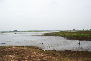
Nong Chang Phriang
Open Days: Open Daily
Opening Hours: Morning To Evening Is Recommended
Nong Chang Phriang is a local water area and leisure spot in Tha Sao Subdistrict, Mueang Uttaradit District, Uttaradit Province. It is located around Chang Phriang, Moo 6, and serves as a community water-retention area as well as a quiet place for local relaxation. The site is suitable for visitors who want a simple, peaceful, and easy-access place near Uttaradit city, especially for walking, resting, photography, and enjoying a local waterside atmosphere without traveling far from town.
The appeal of Nong Chang Phriang lies in its simplicity. It is not a large dam, a famous lake, or a commercial tourist attraction, but rather a community water landscape that reflects the relationship between local people and water. Visitors can experience an open waterside atmosphere, calm scenery, and the everyday character of Tha Sao Subdistrict. For those who enjoy quiet local places, Nong Chang Phriang offers a gentle and authentic side of Uttaradit.
Nong Chang Phriang is located in Tha Sao Subdistrict, an important community area of Mueang Uttaradit District. Tha Sao is close to Uttaradit city and connected to local roads, temples, restaurants, and riverside areas along the Nan River. This makes the site convenient for short visits, especially for travelers who already plan to explore Uttaradit city, Wat Yai Tha Sao, Wat Tha Thanon, local cultural sites, or restaurants in the Tha Sao area.
The area around Nong Chang Phriang has been improved so that local people can use it more comfortably. Local authorities have worked on landscape improvement and earth embankments around the pond to help protect the water area from unwanted runoff and waste. This shows that the site has value not only as a recreation area but also as a community water-retention resource for Tha Sao Municipality.
For travel, Nong Chang Phriang is best suited for light activities such as walking, sitting by the water, taking photos, relaxing in the morning or late afternoon, and observing a local community landscape. It is especially suitable for elderly visitors, families, and people who prefer quiet places rather than crowded tourist attractions. The best time to visit is usually early morning or late afternoon, when the weather is cooler and the light is softer.
Community water areas like Nong Chang Phriang are important for more than scenery. They help support local water management, provide open space, create a small habitat for plants and wildlife, and improve the environmental quality of the community. A pond in a residential area can function as both a practical water resource and a public leisure space when it is maintained properly.
Visitors should understand that Nong Chang Phriang is a community space rather than a developed attraction with full tourist facilities. Responsible behavior is essential. Visitors should not litter, throw waste into the water, disturb wildlife, make excessive noise, or damage the embankments and surrounding area. Keeping the place clean helps preserve it for local residents and future visitors.
The name “Nong Chang Phriang” reflects the local identity of the area. “Nong” means a pond or local water body, while Chang Phriang is the name associated with the Moo 6 area of Tha Sao Subdistrict. This makes the name closely tied to the geography and community memory of the place.
Tha Sao Subdistrict also has cultural and community attractions nearby. A visit to Nong Chang Phriang can be combined with Wat Yai Tha Sao, Wat Tha Thanon, Uttaradit city cultural sites, the Nan River area, local cafés, and restaurants. This makes it a suitable stop for travelers who want to explore the quieter side of Uttaradit without going far from the city.
Morning visits are pleasant because the air is cooler and the waterside scenery feels fresh. Late afternoon visits are also recommended for soft light and a calmer mood. The water surface, sky, embankments, plants, and local surroundings can create simple but attractive photography compositions. Visitors should avoid entering wet or unstable ground, especially after rain.
Nong Chang Phriang is also useful as a small learning site for community water management. The improvement of the landscape and embankments shows how a local pond can support public use, environmental protection, and community quality of life at the same time. Such places may look modest, but they are important to local residents because they are part of daily life and local environmental care.
Visitors should prepare basic items such as drinking water, a hat, sun protection, comfortable walking shoes, and a small trash bag. If visiting during the hot part of the day, shade may be limited in some areas, so morning or late afternoon remains more comfortable. Those planning to sit for a while should avoid blocking local paths or private access areas.
Families with children should keep children away from the water edge unless closely supervised. Community ponds can have uneven depth, soft ground, or slippery edges. Visitors should not enter the water unless there is a designated safe area, and should avoid walking on wet embankments or unstable ground after rainfall.
During the rainy season, the water level may rise and the surrounding area may become wet or muddy. Visitors should check the ground before walking close to the pond. During the dry season, the embankment and pond edges may be more visible, but visitors should still avoid activities that could damage the landscape or create fire risk around dry vegetation.
Nong Chang Phriang can be part of a short Uttaradit city route. Travelers may begin in the city center, visit temples or cultural sites, continue to Tha Sao Subdistrict, relax at Nong Chang Phriang, then end the day at a local restaurant or café. This kind of route is ideal for slow travel and for visitors who want to see community life rather than only major landmarks.
Because the site is close to Uttaradit city, accommodations are easy to find in the city center and nearby areas. Visitors can stay in hotels around Tha Sao, Tha It, or central Uttaradit, then make a short trip to Nong Chang Phriang. This makes the site convenient for travelers who prefer comfortable city accommodation while still visiting local community areas.
Getting There is most convenient by private car or motorcycle. From Uttaradit city, travel toward Tha Sao Subdistrict and continue to the Chang Phriang area in Moo 6. Visitors who are unfamiliar with the exact route should use a map together with local guidance from residents or Tha Sao Municipality.
The main local contact authority is Tha Sao Municipality, which oversees the local area of Tha Sao Subdistrict. Visitors who need current information about access, site conditions, or local regulations can contact the municipality during working hours.
In summary, Nong Chang Phriang is a quiet community water area and leisure spot in Tha Sao Subdistrict. Its value lies in its easy access, local atmosphere, water-retention function, and peaceful setting near Uttaradit city. With responsible behavior and respect for the community, it can be a pleasant stop for travelers who want a calm and local side of Uttaradit.
| Name | Nong Chang Phriang |
| Location | Chang Phriang Area, Moo 6, Tha Sao Subdistrict, Mueang Uttaradit District, Uttaradit Province |
| Address | Moo 6, Tha Sao Subdistrict, Mueang Uttaradit District, Uttaradit 53000, Thailand |
| Highlights | Community water-retention area and leisure spot suitable for walking, resting, photography, and enjoying a quiet local waterside atmosphere near Uttaradit city |
| Distinctive Features | A water-retention area of Tha Sao Municipality with landscape improvement and embankments around the pond for public use and environmental protection |
| Natural Environment | Open local water landscape, waterside area, embankments, community surroundings, and a calm atmosphere suitable for light recreation |
| Recommended Activities | Walking, sitting by the water, photography, relaxing, observing community landscape, and exploring nearby Tha Sao attractions |
| Travel Information | From Uttaradit city, travel toward Tha Sao Subdistrict and continue to the Chang Phriang area in Moo 6; private car or motorcycle is recommended |
| Current Status | Community water-retention area and leisure space of Tha Sao Subdistrict; no permanent closure information found |
| Open Days | Open daily |
| Opening Hours | Morning to evening is recommended |
| Recommended Items | Drinking water, hat, sun protection, comfortable walking shoes, and a small trash bag |
| Safety Notes | Supervise children near the water, do not enter the water unless a safe area is clearly designated, avoid wet or unstable embankments, and do not litter |
| Caretaker / Contact Authority | Tha Sao Municipality |
| Main Contact Number | 055-444-046 |
| Official Website / Official Page | www.thasao.go.th / Tha Sao Municipality, Mueang Uttaradit District, Uttaradit Province |
| Nearby Tourist Attractions | 1. Wat Yai Tha Sao, about 4 km 2. Wat Tha Thanon, about 5 km 3. Uttaradit Provincial Cultural Hall, about 6 km 4. Uttaradit City Museum, about 6 km 5. Tha Sao Nan River Bridge, about 6 km 6. Uttaradit City Center, about 7 km |
| Nearby Restaurants | 1. Local Food Shops In Tha Sao Subdistrict, about 2 km 2. Khrua Nam Ya Pla Phao, Tha Sao, about 5 km 3. Khwai Khwai Restaurant, Tha Sao, about 5 km 4. Energy Coffee Roaster, Tha Sao Riverside, about 6 km 5. Check-In Rim Nan, Tha Sao, about 6 km 6. Restaurants In Uttaradit City Center, about 7 km |
| Nearby Accommodations | 1. Daily Rooms / Dormitory-Style Stays In Tha Sao Subdistrict, about 4 km 2. Sunee Boutique Hotel, about 6 km 3. K2 Living Hotel Uttaradit, about 7 km, Tel. 055-411548, 090-243-4468 4. Seeharaj Hotel Uttaradit, about 8 km, Tel. 055-832790 5. Friday Hotel Uttaradit, about 8 km, Tel. 055-832775-9 6. B-Cozy Hotel Uttaradit, about 8 km |
Frequently Asked Questions (FAQ)
Q: Where is Nong Chang Phriang located?
A: Nong Chang Phriang is located around Chang Phriang, Moo 6, Tha Sao Subdistrict, Mueang Uttaradit District, Uttaradit Province.
Q: What activities are suitable at Nong Chang Phriang?
A: Suitable activities include walking, resting by the water, photography, enjoying the local waterside atmosphere, and exploring nearby Tha Sao attractions.
Q: What type of place is Nong Chang Phriang?
A: It is a community water-retention area and leisure space of Tha Sao Subdistrict.
Q: Has Nong Chang Phriang been improved for public use?
A: Yes. The area has undergone landscape improvement and embankment work so that people can use the area more comfortably and to help protect the water source.
Q: What is the best time to visit Nong Chang Phriang?
A: Morning or late afternoon is recommended because the weather is cooler and the light is suitable for walking and photography.
Q: Is Nong Chang Phriang suitable for children and elderly visitors?
A: It is suitable for light recreation, but children should be supervised near the water and visitors should avoid wet or unstable ground.
Q: What nearby places can be visited with Nong Chang Phriang?
A: Nearby places include Wat Yai Tha Sao, Wat Tha Thanon, Uttaradit Provincial Cultural Hall, Uttaradit City Museum, and Uttaradit city center.
Q: Who can visitors contact for local information?
A: Visitors can contact Tha Sao Municipality at 055-444-046.
 Category: ●Nature and Wildlife
 Group: ●Other natural attractions
Last Update : 4 MonthAgo
 Last Update : 4 MonthAgo
 Click to Access the Navigation Map GPS
 Art, Culture and Heritage
 Historical Sites and Monuments(2)
 Landmarks and Memorials(8)
 Art, Craft Centres, Tradition(3)
 Museums(1)
 Historic Homes and Cities(1)
 Places of Worship
 Temple(42)
 Other Sacred Sites(5)
 Suburban Living
 Village, Community(4)
 National Parks and Marine Reserves(4)
 Mountain (Doi)(3)
 Dam, Reservoir, Lake(3)
 Waterfalls(11)
 Caves(3)
 River, Canal(3)
Other natural attractions(3)
River, Canal(3)
Other natural attractions(3)
 Entertainment and Agricultural
 Farms, Parks and Ecotourism(1)


