
lovethailand home >South Travel Attractions >Yala Travel Attractions >Muang Yala >Lam Pha Ya > Lam Phaya Dam
TL;DR: Lam Phaya Dam is located at Lam Phaya Subdistrict, Mueang Yala District, Yala Province, Thailand, open Daily, hours 08.00 - 17.00.

Lam Phaya Dam
Open Days: Daily
Opening Hours: 08.00 - 17.00
Lam Phaya Dam in Yala Province, also known locally as Khuean Farang or Nop Farang, is a community-based natural attraction and local history learning site in Lam Phaya Subdistrict, Mueang Yala District. Its main identity is a small water-retention dam built across a basin that was once part of an old mining landscape. Over time, nature and the local community transformed this former industrial area into a forest-framed water source fed by the headwater stream and Butong Waterfall. The result is a quiet destination that combines water scenery, community life, mining history, and nature close to Yala city.
The appeal of Lam Phaya Dam lies not only in its reservoir-like basin and green surroundings, but also in the story of Lam Phaya’s tin-mining past. During the 1920s-1930s, a British company came into the valley area of Lam Phaya to explore and operate tin mining. The mining area included both upper and lower sections. The upper mine used water pressure for washing ore, while the lower mine involved dredging. Because modern water-pressure machinery was not available in the same way as today, a small dam or water-retaining barrier was built to store water and create enough pressure for mineral washing. This gives Lam Phaya Dam historical value as a trace of Yala’s former mining economy.
The local name “Nop Farang” is understood by the community as a water barrier built by foreigners. Although the original mining function ended long ago, the basin and the dam remain part of the community landscape. Today, the site serves as a water source, a resting place, and the endpoint of a community walking route within Lam Phaya’s local learning area. Visitors can still read the area’s past through the landform, the water, the route, and the stories preserved by local people.
The landscape around Lam Phaya Dam combines water, forested hills, orchards, and rubber plantations. The route to the dam passes through community and agricultural areas, giving visitors a strong sense of Lam Phaya as a green subdistrict surrounded by nature. Along the way, rubber trees, fruit orchards, and mountain slopes create a shaded and rural atmosphere. The journey itself is part of the experience because travelers gradually move from Yala city into a quieter local landscape before reaching the water source.
The water basin above the dam remains filled because it is fed by upstream water connected with Butong Waterfall. Butong Waterfall is a small waterfall in Lam Phaya with year-round water flow, a long stream, shallow pools suitable for recreation in certain sections, and shaded surroundings. The relationship between Butong Waterfall and Lam Phaya Dam is central to understanding the site: the waterfall provides the natural flow, while the dam stores and holds water for the landscape and the community.
The rainy season and the post-rainy period are the most scenic times to visit. When the water volume rises, the waterfall feeds the upper basin and water may flow over the dam crest, creating a curtain-like fall. This image of water moving over the old dam, set against the greenery of Lam Phaya, gives the site a beauty different from large modern reservoirs. It is a small community water source with a very specific history and atmosphere.
Lam Phaya Dam is suitable for travelers who enjoy quiet natural places near town and want to understand a local community beyond ordinary sightseeing. The site offers water views, forest sounds, a calm rural atmosphere, and a history that connects mining, water use, and community adaptation. Visitors can take photos, rest near the water, walk the community route, and combine the dam with Butong Waterfall and other learning sites in Lam Phaya Subdistrict.
Lam Phaya is an old community in Mueang Yala District. Local stories connect the name Lam Phaya with the term “Lam Phaya,” interpreted in relation to a historical intermediary or interpreter in the old Yala area. The subdistrict is now divided into 7 villages: Ban Nuea, Ban Lam Phaya, Ban Phru, Ban Thamniap, Ban Ok, Ban Thong Lon, and Ban Ton Yi. The area consists of rolling land, surrounding hills, farms, water sources, forest, and community settlements.
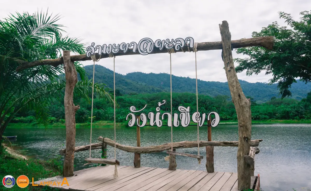
Lam Phaya is also known for cultural and religious coexistence. Thai Buddhist and Thai Muslim communities have lived in the area for generations. The subdistrict’s learning route includes Wat Siripunnaram, local mosques, the biodiversity research center, Tham Nam Lot Cave, Wang Nam Khiao, Butong Waterfall, and local community products such as salted eggs, tie-dyed fabric, mochi-style local sweets, rolled wafers, and solar-energy products. For this reason, Lam Phaya Dam works best as part of a community travel route rather than as a single isolated stop.
Travelers should understand that the name “Lam Phaya Dam” can refer to more than one water-related context in the area. In community tourism, it refers to Khuean Farang or Nop Farang, the old dam connected with the former mining basin and Butong Waterfall. Separately, Lam Phaya also has the Lam Phaya Reservoir Project under royal initiative, a major irrigation and water-management project developed to support agriculture, household water use, and flood mitigation. Both reflect the importance of water to Lam Phaya, but they have different roles and characters.
Historically, Khuean Farang or Nop Farang is one of the clearest traces of Lam Phaya’s tin-mining era. Old mining activity left basins, dug areas, and water landscapes that later became community water sources. Wang Nam Khiao, another large water body in Lam Phaya, is also associated with dredging during the mining period. Together, Lam Phaya Dam, Butong Waterfall, and Wang Nam Khiao show how the community landscape has changed from mining infrastructure into nature, water use, and learning spaces.
Wang Nam Khiao adds another layer to the story. It is a large water source in Lam Phaya that originated from dredging during the tin-mining period. Its scenery and water surface help visitors understand that Lam Phaya’s present landscape is closely tied to its mining past. When combined with Lam Phaya Dam and Butong Waterfall, the route tells a clear story of mountain headwaters, waterfall flow, mined basins, stored water, and community adaptation.
The Queen Sirikit 72nd Birthday Anniversary Biodiversity Research Center of Yala Rajabhat University is another important nearby learning site. It supports conservation, biodiversity awareness, local ecological learning, community knowledge, and nature-based education in the Lam Phaya valley area. Including this center with Lam Phaya Dam and Butong Waterfall turns the visit from a short nature stop into a broader learning experience about forest, water, plants, and local wisdom.
Because Lam Phaya Dam is a community-based natural site, preparation is important. Visitors should wear suitable shoes with good grip, especially during the rainy season when paths near water can become slippery. Drinking water, snacks, mosquito repellent, waterproof bags for phones or cameras, and a trash bag are useful. Those who want to play in the water around Butong Waterfall should choose calm and shallow areas only.
The best time to visit is from morning to late afternoon, when there is enough daylight for walking and enjoying the natural surroundings safely. The rainy and post-rainy periods are especially beautiful because the water flow is stronger and the dam area looks more active. The dry season is easier for travel, and the basin remains meaningful because the site continues to receive water from the upstream system. Travelers who want to see water flowing over the dam should visit after periods of steady rain and check weather conditions before traveling.
Responsible travel is essential. Lam Phaya Dam is not a large commercial attraction; it is a community water source and natural area. Visitors should not throw trash into the water, use soap or chemicals in the stream, climb risky sections of the dam, make excessive noise, damage plants, or enter unclear areas without local guidance. Groups should contact Lam Phaya Subdistrict Administrative Organization or local residents in advance when planning a larger visit.
Getting there from Yala city is straightforward by private car, motorcycle, or locally hired vehicle. Lam Phaya Subdistrict is about 20 km from the city. The route connects with Highway 409 and Highway 4068 before entering local community roads toward Khuean Farang or Nop Farang. Some parts of the route lead into natural and community areas, so travelers should use map navigation together with local directions.
Visitors who are unfamiliar with the area should begin from Yala city and contact Lam Phaya Subdistrict Administrative Organization or ask local residents for route details. This is especially useful during the rainy season or when combining the dam with Butong Waterfall and other learning sites. Local advice helps identify which sections are suitable for vehicles, where to walk, where water recreation is safe, and how long the visit should take.
A half-day itinerary can begin in Yala city in the morning, continue to Lam Phaya Dam and Butong Waterfall, then include nearby community learning points such as Wang Nam Khiao, Tham Nam Lot Cave, or Wat Siripunnaram before returning to Yala city in the afternoon. This plan is suitable for travelers who have limited time but want nature and local history close to town.
A full-day itinerary gives a more complete understanding of Lam Phaya. Start with Lam Phaya Dam and Butong Waterfall in the morning, then continue to Wang Nam Khiao, the biodiversity research center, Tham Nam Lot Cave, Wat Siripunnaram, and local community products such as salted eggs, tie-dyed cloth, local sweets, rolled wafers, or solar-energy products. This route shows that Lam Phaya is not only a waterfall and dam area but also a community of nature, faith, food, craft, and learning.
Travelers can also combine Lam Phaya with Yala city landmarks such as Yala City Pillar Shrine, Khwan Mueang Park, Yala Clock Tower, the Rainbow Buildings near Yala Railway Station, and restaurants in the city center. Because Lam Phaya is not far from Yala city, a practical route can include nature in the morning and city landmarks in the late afternoon or evening.
Lam Phaya Dam is suitable for families, students, local-history travelers, photographers, and visitors who prefer calm places rather than crowded attractions. Families should supervise children near water and rocky areas. Elderly travelers should choose easy walking sections and avoid slippery surfaces. During heavy rain, visitors should delay the trip or focus on safer community learning sites instead.
For photography, Lam Phaya Dam offers water-basin views, the dam crest, water flow during the rainy season, community paths, rubber plantations, orchards, and the shaded atmosphere of the route. Morning light creates a fresh and soft look, while late afternoon gives warmer reflection on the water. Photographers should protect lenses and phones from moisture and avoid standing on slippery or risky sections for the sake of a photo.
Food and services around Lam Phaya are community-based rather than concentrated like a large tourism center. Visitors should carry drinking water and snacks or plan meals in Yala city before or after the trip. Yala city offers a wide range of restaurants, including halal food, breakfast shops, noodle shops, seafood restaurants, Thai food, and cafés, making it practical to combine Lam Phaya with city dining.
The most convenient accommodation base for visiting Lam Phaya Dam is Yala city. Hotels in the city provide more choices and allow travelers to reach Lam Phaya without a long drive. A simple plan is to stay overnight in Yala city, visit Lam Phaya in the morning, and return to the city for food, markets, train connections, or other attractions later in the day.
Overall, Lam Phaya Dam is more meaningful than a small dam alone. It brings together the history of tin mining, a former mining basin, community water use, Butong Waterfall, orchards, rubber plantations, and the transformation of old industrial land into a natural and educational community space. Visitors who come here gain a quieter but deeper understanding of one part of Yala’s local landscape.
In summary, Lam Phaya Dam in Yala Province is a natural and historical community destination in Mueang Yala District. Its key features are the water basin formed from an old mining area, the year-round water connection with Butong Waterfall, the green route through orchards and rubber plantations, and the story of Nop Farang from Lam Phaya’s tin-mining past. The best visit is made in the morning or late afternoon, with proper footwear, care around water, respect for the community, and enough time to combine the dam with Butong Waterfall and other Lam Phaya learning sites.
| Name | Lam Phaya Dam |
| Related Names | Khuean Farang / Nop Farang |
| Place Type | Small Water-Retention Dam, Community Water Source, Natural Attraction, And Local Mining-History Learning Site |
| Location | Lam Phaya Subdistrict, Mueang Yala District, Yala Province, Thailand |
| Address Summary | Lam Phaya Dam Or Khuean Farang, Lam Phaya Subdistrict, Mueang Yala District, Yala Province 95160, Thailand |
| Reference Coordinates For Lam Phaya Weir Area | 6.579616, 101.152978 |
| Highlights | Old Mining Basin, Butong Waterfall, Year-Round Water, Forested Hills, Orchards, Rubber Plantations, And Lam Phaya Tin-Mining History |
| Distinctive Features | A Dam Built Across A Former Mining Basin, Fed By Headwater Flow From Butong Waterfall, Keeping The Upper Basin Filled Throughout The Year |
| Historical Importance | Connected With Tin-Mining Operations By A British Company During The 1920s-1930s, When A Water Barrier Was Built To Support Ore-Washing Work |
| Interesting Points | Dam Crest, Upper Water Basin, Community Walking Route, Butong Waterfall, Wang Nam Khiao, Tham Nam Lot Cave, And Lam Phaya Community Learning Sites |
| Main Areas / Zones | Upper Water Basin, Dam Crest, Community Walking Route, Butong Waterfall Zone, Orchard And Rubber Plantation Route, And Lam Phaya Learning Site Area |
| Travel Information | From Yala City, Travel About 20 Km To Lam Phaya Subdistrict Via Routes Connected With Highway 409 And Highway 4068, Then Continue On Local Community Roads Toward Khuean Farang Or Nop Farang |
| Current Status | A Community Natural Attraction And Learning Site In Lam Phaya Subdistrict |
| Open Days | Daily |
| Opening Hours | 08.00 - 17.00 |
| Fees | No Official Ticketing System Is Listed. Visitors Should Prepare Personal Expenses Such As Local Transport, Food, Drinks, Or Community Services If Needed |
| Best Time To Visit | Morning To Late Afternoon; Rainy And Post-Rainy Periods Are Best For Butong Waterfall And Water Flow Over The Dam |
| Facilities | Community-Based Natural Site. Visitors Should Bring Drinking Water, Snacks, Good-Grip Shoes, Waterproof Protection, And A Trash Bag |
| Safety Notes | Wet Areas Near Waterfalls And Streams Can Be Slippery, Especially During The Rainy Season. Avoid Strong Water, Do Not Climb Risky Dam Sections, And Follow Local Guidance |
| Management / Local Contact | Lam Phaya Subdistrict Administrative Organization, Mueang Yala District, Yala Province |
| Main Contact Number | Lam Phaya Subdistrict Administrative Organization Tel. 073-276-227 |
| Nearby Tourist Attractions | 1. Butong Waterfall, About 1 - 2 Km 2. Wang Nam Khiao, Lam Phaya Subdistrict, About 3 - 5 Km 3. Tham Nam Lot Cave, Lam Phaya Subdistrict, About 5 - 7 Km 4. Queen Sirikit 72nd Birthday Anniversary Biodiversity Research Center, About 5 - 8 Km 5. Wat Siripunnaram Or Wat Lam Phaya, About 5 - 8 Km 6. Yala City Pillar Shrine, About 20 - 25 Km 7. Khwan Mueang Park, Yala, About 22 - 27 Km |
| Nearby Restaurants / Suitable Stops For Trip Planning | 1. Krua Kan Eng, Mueang Yala, About 20 - 25 Km, Tel. 082-801-5309, 093-061-4762, 063-675-4086 2. Kuay Jap Peek Kai Thep Wiman, Mueang Yala, About 20 - 25 Km, Tel. 073-213-265, 081-276-9629, 089-655-7629 3. Nisa Chicken Rice & Kampong Noodle, Mueang Yala, About 20 - 25 Km, Tel. 063-102-0840 4. Ho Jia Breakfast And Cooked-To-Order Food, Phang Mueang 4, About 20 - 25 Km, Tel. 087-477-6571, 086-291-5898, 082-731-1563, 087-899-3207 5. Cha Yen Phang Mueang 4, About 20 - 25 Km, Tel. 062-468-7860 6. Wun Khun Cheer, Mueang Yala, About 20 - 25 Km, Tel. 073-215-190 |
| Nearby Accommodations | 1. Yala Grand Palace Hotel, About 20 - 25 Km, Tel. 073-215-711, 073-215-712 2. Park View Hotel Yala, About 20 - 25 Km, Tel. 073-217-001-5 3. @INN YRU, About 20 - 25 Km, Tel. 062-182-2662 4. Yala Rama Hotel, About 20 - 25 Km, Tel. 073-221-990-2 5. Metro Hotel Yala, About 20 - 25 Km, Tel. 073-212-175 |
Frequently Asked Questions (FAQ)
Q: Where Is Lam Phaya Dam Located?
A: Lam Phaya Dam is located in Lam Phaya Subdistrict, Mueang Yala District, Yala Province. It is a natural community attraction and learning site not far from Yala city.
Q: Are Lam Phaya Dam, Khuean Farang, And Nop Farang The Same Place?
A: In the community tourism context, they refer to the same site. Khuean Farang or Nop Farang is the local name for the old water-retention dam connected with Lam Phaya’s tin-mining history.
Q: What Are The Opening Days And Hours?
A: Lam Phaya Dam is open daily from 08.00 to 17.00.
Q: Is There An Entrance Fee?
A: No official ticketing system is listed. Visitors should prepare personal expenses such as local transport, food, drinks, or community services if needed.
Q: What Is The Main Highlight Of Lam Phaya Dam?
A: The main highlight is a dam built across a former mining basin, fed by Butong Waterfall throughout the year, surrounded by orchards, rubber plantations, forested hills, and the history of Lam Phaya’s tin-mining period.
Q: When Is The Best Time To Visit?
A: Morning to late afternoon is the best visiting period. The rainy and post-rainy seasons are especially good for seeing Butong Waterfall and water flowing over the dam.
Q: Which Nearby Places Can Be Combined With Lam Phaya Dam?
A: Nearby places include Butong Waterfall, Wang Nam Khiao, Tham Nam Lot Cave, the biodiversity research center, Wat Siripunnaram, Yala City Pillar Shrine, and Khwan Mueang Park.
Q: What Should Visitors Prepare Before Going?
A: Visitors should bring drinking water, good-grip shoes, waterproof protection, a trash bag, mosquito repellent, and check weather conditions, especially during the rainy season or when planning to play in the water around Butong Waterfall.
 Category: ●Nature and Wildlife
 Group: ●Dam, Reservoir, Lake
Last Update : 2 WeekAgo
 Last Update : 2 WeekAgo
 Click to Access the Navigation Map GPS
 Art, Culture and Heritage
 Landmarks and Memorials(1)
 Art, Craft Centres, Tradition(2)
 Museums(2)
 Educational Places
 Educational Gardens, Farm(1)
 Places of Worship
 Temple(6)
 Mosque(2)
 Other Sacred Sites(3)
 Suburban Living
 Village, Community(4)
 National Parks and Marine Reserves(2)
 Mountain (Doi)(5)
Dam, Reservoir, Lake(5)
Mountain (Doi)(5)
Dam, Reservoir, Lake(5)
 Waterfalls(13)
 Hot Springs(2)
 Caves(7)
 River, Canal(4)
 Islands(1)
 Other natural attractions(8)
 Entertainment and Agricultural
 Stadium(1)
 Farms, Parks and Ecotourism(4)
 Outdoor and Adventure Activities(1)
 Travel Articles, Recipes
 Travel Review, Food Review(2)


