
lovethailand home >South Travel Attractions >Satun Travel Attractions >Khuan Ka Long >Khuan Ka Long > Namtok Dao Krachai
TL;DR: Namtok Dao Krachai is located at Moo 11, Khuan Kalong Subdistrict, Khuan Kalong District, Satun Province, near Ban San Daeng Border Patrol Police School, open Daily, hours 08.00 – 17.00.

Namtok Dao Krachai
Open Days: Daily
Opening Hours: 08.00 – 17.00
Namtok Dao Krachai in Satun Province is a natural waterfall in Khuan Kalong District, best known for the way its water drops from a high rock face and bursts into fine spray when it hits the stones below. This star-like scattering of water gives the waterfall its Thai name, “Dao Krachai,” meaning scattered stars. The waterfall is located within Namtok Dao Krachai Forest Park at Moo 11, Khuan Kalong Subdistrict, Khuan Kalong District, Satun Province, near Ban San Daeng Border Patrol Police School. It has year-round water flow, natural pools suitable for safe bathing, a parking area, and a quiet forest atmosphere that makes it a worthwhile inland nature stop for travellers exploring Satun beyond beaches and islands.
The waterfall is closely linked with the mountain landscape of southern Thailand. Its headwater comes from the Nakhon Si Thammarat mountain range, also commonly associated with the Banthat range, which forms an important natural boundary between Phatthalung and Satun. On the Phatthalung side, the landscape connects with Pa Bon District, while the Satun side forms part of Khuan Kalong’s forested hill country. This mountain setting gives Dao Krachai its steady stream, rocky cascades, and powerful downward flow.
Although Dao Krachai is often described as a small waterfall in terms of tourist-site scale, its character is distinctive. The waterfall is known for a relatively high drop, strong water movement, and a striking spray pattern at the base. Unlike broad, shallow waterfalls that flow gently over low rock terraces, Dao Krachai has a more dramatic form. The water falls with force, hits the rock below, and spreads outward in a bright white burst, creating the visual effect that made the site famous among local nature travellers.
The surrounding area is important to the local community because the waterfall is a village headwater source and lies near Ban San Daeng. This relationship between forest, stream, and village is central to the identity of the place. The forest supplies water, the stream supports the landscape, and local communities benefit from and help preserve the natural environment. A visit to Dao Krachai is therefore not only a waterfall trip, but also a chance to understand how an inland forest watershed supports local life in Khuan Kalong.
Field information from local tourism coverage describes Dao Krachai as a seven-tier waterfall. The named tiers or pools are Wang Phueng, Wang Luk Wa, Wang Phu Yai Lep, Wang Pla Hot, Wang Pla Huat, Wang Mai Pak, and Wang Dao Krachai. The most suitable bathing areas are the lower sections, especially Wang Phueng, Wang Luk Wa, and Wang Phu Yai Lep, which are easier to reach. The route toward the highest section is longer, steeper, and more overgrown. Visitors who want to continue to the uppermost part should contact local people familiar with the route and should not attempt the trail alone.
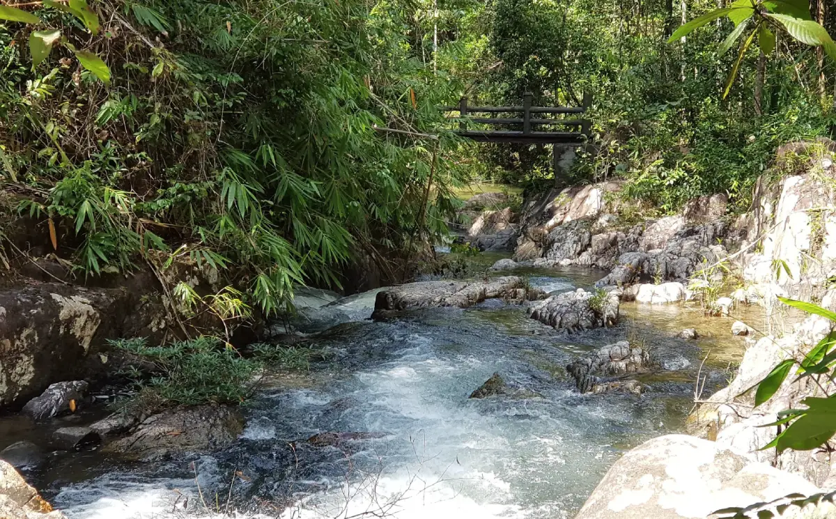
Wang Phueng is a practical starting area for resting by the stream because it is easier to access and suitable for families or visitors who prefer a lighter nature walk. Wang Luk Wa and Wang Phu Yai Lep offer a clearer view of the stream-and-pool character of the waterfall. Visitors can sit by the water, listen to the forest, take photos of the rocks and cascades, or bathe in safe shallow spots. Slippery stones and changing water levels should always be treated with caution.
The upper tiers, including Wang Pla Hot, Wang Pla Huat, Wang Mai Pak, and Wang Dao Krachai, feel more forested and are better suited to visitors with hiking experience. The path to the top is not an ordinary casual walking route. It passes through forest terrain, steeper sections, and areas that may be wet or overgrown. Anyone planning to continue upward should allow enough time, use local guidance, and avoid heavy-rain conditions.
The overall atmosphere of Dao Krachai remains strongly natural. Dense tropical vegetation surrounds the waterfall, the forest provides deep shade, and the stream flows over dark rocks along the route. Visitors can experience the coolness of southern forest, the smell of damp earth, the sound of water, insects, and birds, and a slower rhythm than more commercial tourist destinations. The site is best appreciated by walking carefully and spending time observing the forest rather than rushing through it.
Suitable activities include nature walking, bathing in safe pools, waterfall photography, plant observation, streamside relaxation, and family day trips. The beauty of Dao Krachai is not created by buildings or large-scale tourism facilities. It comes from the natural movement of water, the forested setting, the shaded rocks, and the unique spray pattern that gives the waterfall its name.
The best time to visit is from morning to early afternoon, when daylight is strong enough for walking, photography, and safe movement around the stream. During the rainy season, the forest becomes lush and the water volume is more impressive, but visitors must be careful of sudden rain, slippery trails, and fast-changing water flow. During the drier months, the waterfall remains visitable because it has year-round water, although the volume may vary.
Swimming or bathing should be limited to safe, shallow areas where the current is not too strong. Visitors should avoid climbing wet cliffs, jumping into pools without knowing their depth, or entering the water after heavy rain. Children and older travellers should stay mainly in the lower sections and remain under close supervision. Waterfalls in forested mountain areas can change quickly, especially after intense rain.
For photographers, Dao Krachai offers strong visual elements: falling water, rock surfaces, forest shadows, stream channels, and filtered light through the canopy. Morning light works well because it is softer and reduces harsh reflections on the water. After rain, the forest appears greener and the spray can be especially photogenic. Photographers should avoid damaging plants, moving rocks, or standing in unsafe positions for a better angle.
Useful items to bring include non-slip footwear, quick-dry clothing, a towel, drinking water, light food, a dry bag for phones or cameras, mosquito repellent, and a personal rubbish bag. There is no regular restaurant inside the waterfall area, so visitors should prepare food and water appropriately. All food waste and packaging should be taken back out to keep the headwater clean and to avoid changing the behaviour of wildlife.
Responsible behaviour is essential. Visitors should not leave rubbish, play loud music, wash dishes in the stream, carve names on rocks or trees, catch aquatic animals, collect plants, or leave designated paths unnecessarily. Dao Krachai is both a tourism site and a village headwater area. Keeping it quiet and clean respects both nature and the local community.
Getting There to Namtok Dao Krachai is easiest by private car or motorcycle. Travel toward Khuan Kalong District, then follow the route toward Nikhom Soi 10 and Ban San Daeng. The waterfall is near Ban San Daeng Border Patrol Police School, and the access route is about 25 km from the Nikhom Soi 10 junction. Public transport is not convenient for direct access, so private transport gives travellers better control over time and safety.
Travellers from Satun town can plan this as a Khuan Kalong inland nature trip. Drive into Khuan Kalong District and continue toward Ban San Daeng and the forest park. Travellers from Hat Yai or Phatthalung should check the route in advance and allow extra time because the final approach passes through rural, forested, and hill-country areas. Extra care is needed during and after rain because some sections may become slippery.
A practical itinerary can place Dao Krachai as the main waterfall stop and combine it with Sai Jai Waterfall, Namtok Thara Sawan Forest Park, Thung Nui Hot Spring, Wat Kumphin Banphot, or cafés and restaurants in Khuan Kalong. A relaxed half-day plan is often enough for the waterfall itself, while a full-day route can include nearby nature attractions and a meal in the district centre.
Dao Krachai helps reveal another side of Satun. The province is often known for Ko Lipe, Ko Tarutao, and the Andaman Sea, but Khuan Kalong shows Satun’s inland identity: mountains, waterfalls, rubber and fruit-growing communities, forest watersheds, and quiet streams. Visiting Dao Krachai gives travellers a clearer view of Satun’s natural diversity beyond the coast.
The waterfall is suitable for travellers who enjoy simple, less-developed nature sites, families who want a quiet forest outing, photographers, waterfall lovers, and visitors looking for a non-marine Satun itinerary. Its strengths are simplicity, forest atmosphere, year-round water, safe lower pools, and the distinctive spray that resembles scattered stars.
The long-term value of Dao Krachai lies in its role as both a natural attraction and a village headwater source. Visitors should use the area carefully, keep the forest quiet, remove their rubbish, and avoid damaging the stream environment. When treated with respect, Namtok Dao Krachai remains a refreshing forest waterfall and an important natural asset of Khuan Kalong District.
| Name | Namtok Dao Krachai / Namtok Dao Krachai Forest Park |
| Location | Moo 11, Khuan Kalong Subdistrict, Khuan Kalong District, Satun Province, near Ban San Daeng Border Patrol Police School |
| Address | Ban San Daeng Area, Khuan Kalong Subdistrict, Khuan Kalong District, Satun 91130, Thailand |
| Coordinates | 7.038202, 100.04631 |
| Highlights | A natural forest waterfall with year-round water, a high rock drop, star-like water spray, safe lower pools, and a role as a village headwater source |
| Distinctive Features | Seven waterfall sections: Wang Phueng, Wang Luk Wa, Wang Phu Yai Lep, Wang Pla Hot, Wang Pla Huat, Wang Mai Pak, and Wang Dao Krachai |
| Headwater | Flows from the Nakhon Si Thammarat mountain range, commonly associated with the Banthat range between Phatthalung and Satun |
| Travel Information | Follow the route from Nikhom Soi 10 toward Ban San Daeng and Ban San Daeng Border Patrol Police School. The waterfall access is about 25 km from the Nikhom Soi 10 junction |
| Current Status | Open as a natural attraction and recreation area in Khuan Kalong District |
| Open Days | Daily |
| Opening Hours | 08.00 – 17.00 |
| Fees | No Admission Fee For General Visits |
| Facilities | Parking area, safe lower pools, natural walking route, streamside rest areas, and nearby local community access |
| Main Areas / Zones | Wang Phueng, Wang Luk Wa, Wang Phu Yai Lep, Wang Pla Hot, Wang Pla Huat, Wang Mai Pak, Wang Dao Krachai, parking area, stream zone, and forest path |
| Caretaker / Local Authority | Forestry authorities responsible for the forest park area and Khuan Kalong Subdistrict Municipality as the local authority |
| Contact Number | Forest Resource Management Office 13 (Songkhla) Tel. 074-205-990 Khuan Kalong Subdistrict Municipality Tel. 0-7475-2457 |
| Nearby Tourist Attractions | 1. Wang Phueng, Namtok Dao Krachai, about 0 km 2. Wang Luk Wa, Namtok Dao Krachai, about 0.2 km 3. Wang Phu Yai Lep, Namtok Dao Krachai, about 0.4 km 4. Sai Jai Waterfall, about 8 km 5. Namtok Thara Sawan Forest Park, about 30 km 6. Thung Nui Hot Spring, about 35 km 7. Wat Kumphin Banphot, about 35 km |
| Nearby Restaurants | 1. Cha @ Kalong Cafe, about 25 km, Tel. 086-955-1522, 092-887-4794 2. Conner Cafe Khuan Kalong, about 25 km, Tel. 081-540-2684 3. Soil Pizza, about 26 km, Tel. 091-049-7047 4. Satun On View, about 30 km, Tel. 081-963-2456 5. Beehive Hill Resort Restaurant, about 35 km, Tel. 074-740-226 |
| Nearby Accommodations | 1. The Green Villa Resort, about 15 km, Tel. 094-114-5101 2. Phu Ton Nam Resort, about 16 km, Tel. 085-891-8197 3. Phuthan Resort Satun, about 17 km, Tel. 093-005-5501 4. Phu Banthat Resort, about 17 km, Tel. 085-796-2548 5. Ing Than Resort, about 17 km, Tel. 074-720-747 6. Beehive Hill Resort, about 35 km, Tel. 074-740-226 |
Frequently Asked Questions (FAQ)
Q: Where is Namtok Dao Krachai located?
A: Namtok Dao Krachai is located within Namtok Dao Krachai Forest Park at Moo 11, Khuan Kalong Subdistrict, Khuan Kalong District, Satun Province, near Ban San Daeng Border Patrol Police School.
Q: When is Namtok Dao Krachai open?
A: It is open daily from 08.00 to 17.00. Morning to early afternoon is the best period for walking, photography, and safe waterfall activities.
Q: Is there an entrance fee?
A: No admission fee is charged for general visits to the waterfall area.
Q: What makes Namtok Dao Krachai special?
A: Its water falls from a high rock face and bursts into spray when it hits the stones below, creating a star-like scattering effect. The waterfall also has year-round water and serves as a village headwater source.
Q: How many tiers does Namtok Dao Krachai have?
A: The waterfall has seven named sections: Wang Phueng, Wang Luk Wa, Wang Phu Yai Lep, Wang Pla Hot, Wang Pla Huat, Wang Mai Pak, and Wang Dao Krachai.
Q: Can visitors swim at Namtok Dao Krachai?
A: Visitors can bathe in safe lower pools such as Wang Phueng, Wang Luk Wa, and Wang Phu Yai Lep. Swimming should be avoided after heavy rain or when the current is strong.
Q: How do visitors get to Namtok Dao Krachai?
A: Travel toward Khuan Kalong District, then follow the route from Nikhom Soi 10 toward Ban San Daeng and Ban San Daeng Border Patrol Police School. The waterfall access is about 25 km from the Nikhom Soi 10 junction.
Q: What nearby places can travellers visit after Namtok Dao Krachai?
A: Nearby options include Sai Jai Waterfall, Namtok Thara Sawan Forest Park, Thung Nui Hot Spring, Wat Kumphin Banphot, and cafés or restaurants in Khuan Kalong District.
 Category: ●Nature and Wildlife
 Group: ●National Parks and Marine Reserves
Last Update : 1 MonthAgo
 Last Update : 1 MonthAgo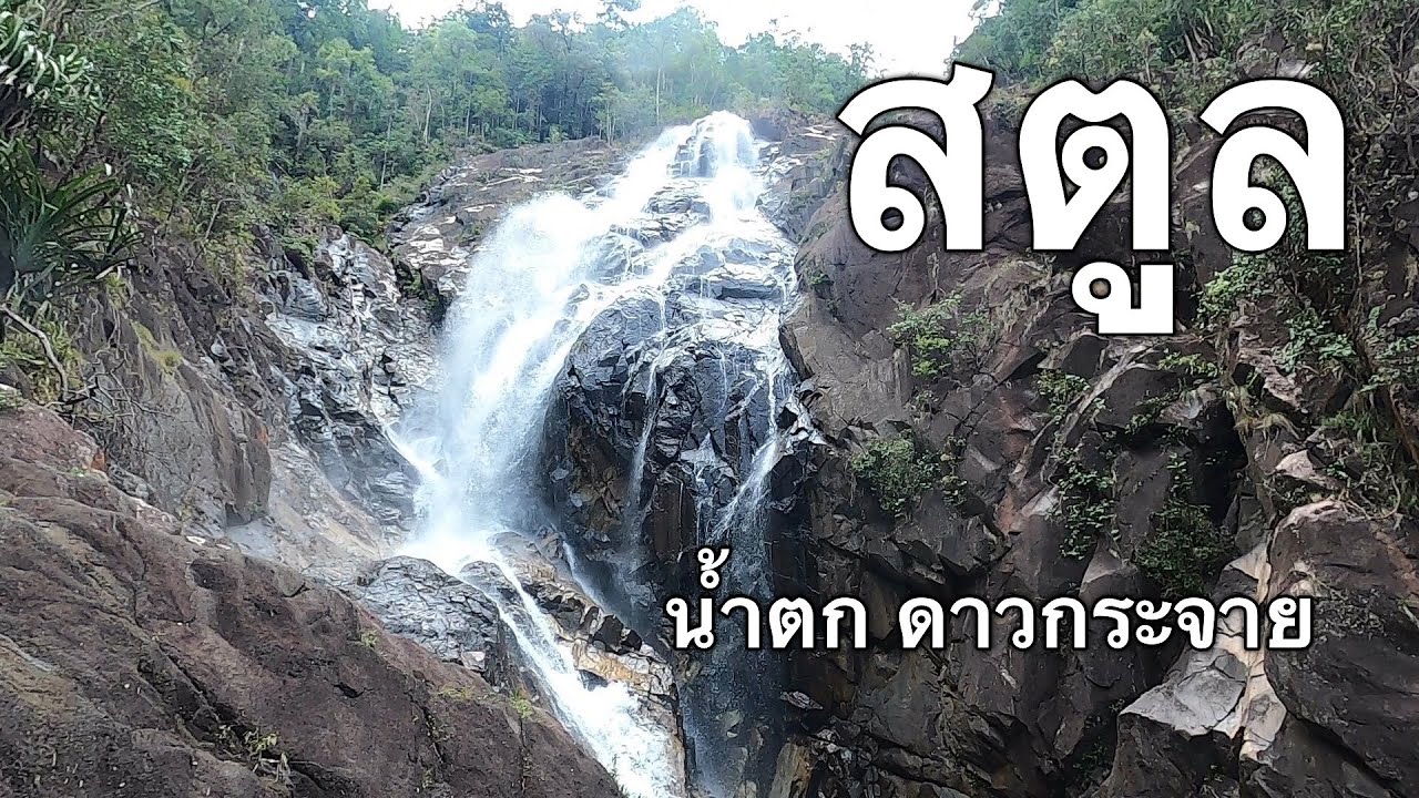
 Click to Access the Navigation Map GPS
Namtok Dao Krachai Map
Recommend

 Art, Culture and Heritage
 Historical Sites and Monuments(1)
 Landmarks and Memorials(1)
 Art, Craft Centres, Tradition(5)
 Museums(3)
 Places of Worship
 Temple(3)
 Mosque(27)
 Suburban Living
 Village, Community(1)
 Local Market(2)
National Parks and Marine Reserves(7)
Local Market(2)
National Parks and Marine Reserves(7)
 Mountain (Doi)(1)
 Dam, Reservoir, Lake(2)
 Waterfalls(9)
 Hot Springs(1)
 Caves(9)
 Bays and Beaches(10)
 Islands(16)
 Other natural attractions(5)
 Entertainment and Agricultural
 Zoos and Aquariums(1)
 Farms, Parks and Ecotourism(4)
 Outdoor and Adventure Activities(1)
 Travel Articles, Recipes
 Travel Review, Food Review(1)


