
lovethailand home >North Travel Attractions >Phayao Travel Attractions >Chiang Muan >Chiang Muan > Fang Ta
TL;DR: Fang Ta is located at Ban Chaiyasathan, Moo 4, Chiang Muan Subdistrict, Chiang Muan District, Phayao Province, open Daily.

Fang Ta
Open Days: Daily
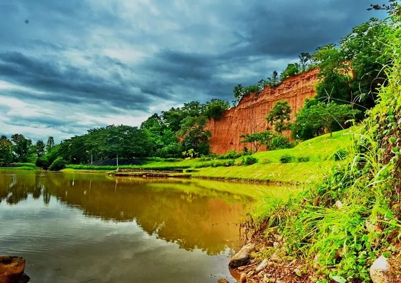
Fang Ta Chaiyasathan in Phayao Province is a distinctive natural attraction in Chiang Muan District, known for its eroded earth cliffs, unusual soil formations, and quiet rural landscape. Located near Ban Chaiyasathan, Moo 4, Chiang Muan Subdistrict, Chiang Muan District, Phayao Province, this site stands out for its half-mountain-like landform shaped by natural erosion over time. The scenery resembles the famous Phae Mueang Phi in Phrae Province and Sao Din Na Noi in Nan Province, yet Fang Ta has its own atmosphere: peaceful, spacious, and closely connected to the local landscape of Chiang Muan.
In simple terms, Fang Ta Chaiyasathan is a natural earth-cliff landscape created by the continuous action of rainwater, flowing water, wind, and soil collapse. Over time, parts of the original landmass were gradually washed away, leaving behind steep walls of earth, deep grooves, narrow ridges, and pillar-like soil formations. From a distance, the site looks like a natural earthen wall or a mountain that has been cut away on one side. Up close, visitors can see layers of soil, erosion lines, and irregular shapes that make the place visually striking and geologically interesting.
Fang Ta is situated on the eastern side of Ban Chaiyasathan, about 5 km from the Chiang Muan District Office. The surrounding area still retains a calm local character, with open natural scenery, rural roads, and nearby communities. This makes Fang Ta especially suitable for travelers who prefer secondary routes, quiet natural attractions, photography spots, and places that are not yet crowded with mass tourism. For visitors exploring Phayao beyond the main city area, Fang Ta offers a different perspective of the province: not only lakes, temples, and cultural sites, but also rare landforms shaped entirely by nature.
The name “Fang Ta” reflects the local understanding of the landscape. The word “Fang” suggests a bank or side of land, while “Ta” is associated with the elevated earthen formation seen in the area. Together with the name of Ban Chaiyasathan, the site is commonly known as Fang Ta Chaiyasathan. The name fits the landscape well, as the attraction appears like a high earthen bank or cliff standing prominently within the local terrain. When viewed from a suitable angle, the earth formation contrasts beautifully with the surrounding greenery and the natural openness of Chiang Muan.
The most impressive feature of Fang Ta Chaiyasathan is the shape of the eroded land itself. The soil has been cut and carved by natural forces into uneven ridges, vertical grooves, and wall-like formations. Some sections look like narrow soil pillars, while others form continuous cliff faces. The visual effect changes depending on the angle, distance, and light. In the morning and late afternoon, soft sunlight adds shadows to the grooves and makes the texture of the soil more dimensional. During brighter midday hours, the shape and color of the soil become clearer, although visitors should prepare for stronger heat.
The site is often compared with Phae Mueang Phi in Phrae and Sao Din Na Noi in Nan because all three attractions are examples of soil erosion landscapes in northern Thailand. However, Fang Ta has a quieter and more local atmosphere. It is not only a place to see unusual soil formations but also a place to experience the natural character of Chiang Muan District. The surrounding context of village, forest, hills, and water gives Fang Ta a broader landscape identity. It feels less like a single isolated landmark and more like part of a living rural environment.
For travelers interested in nature and geology, Fang Ta Chaiyasathan works almost like an open-air classroom. The cliffs and soil ridges show how rainfall, water flow, gravity, and time can reshape landforms. Small channels on the surface indicate paths once taken by water. Steeper soil walls show where material has collapsed or been gradually removed. The attraction therefore helps visitors understand that landscapes are not static. They continue to change slowly, season by season, especially in areas where soil is exposed and vulnerable to erosion.
Fang Ta also offers strong photographic appeal. Wide shots can capture the long earthen formation together with the natural background, while closer shots can focus on the texture of the soil, erosion grooves, and unusual shapes. The site is suitable for landscape photography, travel photography, and content creation for visitors who enjoy “Unseen” natural places in Thailand. Unlike highly developed tourist sites, Fang Ta still feels simple and raw, which gives photographs a natural and authentic mood.
The best way to enjoy Fang Ta is to visit with enough time to walk slowly and observe the details of the landform. Visitors do not need complicated activities here. The value of the place lies in looking closely at what nature has created. The shapes of the cliffs may look different from one viewing point to another. Some sections appear like a broken wall; some resemble half of a hill; some look like narrow vertical ridges left behind after the surrounding soil was washed away. This variety makes the site more interesting than it first appears.
Because Fang Ta is a natural erosion site, visitors should be careful while exploring. The ground may be uneven, and some areas near the edge of the cliff should be avoided. Climbing on the soil walls, digging into the surface, writing on the earth, or damaging the formation should not be done. These formations are part of a fragile natural landscape. Responsible tourism helps preserve the site so that future visitors can continue to appreciate its beauty and educational value.
The dry season is generally convenient for walking and viewing the soil formations clearly, as the ground is easier to access and the shapes of the cliffs are more visible. The rainy season brings greener surroundings and a fresher atmosphere, but visitors should be more cautious because the ground may be slippery and water can affect the soil surface. Morning and late afternoon are good times for comfortable weather and softer light, especially for photography. Travelers should bring drinking water, sun protection, comfortable shoes, and a camera.
Fang Ta Chaiyasathan is suitable for many types of visitors. Families can use the site as a natural learning experience for children. Nature lovers can enjoy the quiet scenery and unusual landforms. Photographers can find many angles for landscape images. Cultural travelers can combine the visit with nearby community-based attractions, temples, and local food stops in Chiang Muan. The site is also suitable for travelers who want to explore Phayao in a slower and more meaningful way, away from the most common tourist routes.
Chiang Muan District itself adds value to a visit to Fang Ta. The district is known not only for natural scenery but also for cultural and historical points of interest. Nearby attractions such as the Dinosaur Forest Park, Phra That Phu Po, Wat Tha Fa Tai, Doi Phu Nang National Park, and Than Sawan Waterfall make it possible to create a well-rounded travel route. A trip to Fang Ta can therefore become part of a full-day itinerary combining natural landscapes, geological learning, local faith, and community culture.
Getting There is most convenient by private car. From Doi Phu Nang National Park, travelers can follow Route 1251, the Dok Kham Tai–Chiang Muan route, for approximately 30 km. From the Chiang Muan District Office, the distance to Ban Chaiyasathan is about 5 km. The route is suitable for self-drive travel, and visitors should check road and weather conditions before departure, especially during the rainy season. Travelers coming from Phayao city can plan Fang Ta as part of a day trip to Chiang Muan or stay overnight in the district to explore nearby attractions at a more relaxed pace.
A practical one-day itinerary can begin in Chiang Muan town, then continue to Fang Ta Chaiyasathan in the morning or late afternoon for the best light. After that, visitors can stop at the Dinosaur Forest Park to learn about fossil discoveries, continue to Phra That Phu Po for a local religious and scenic viewpoint, and visit Wat Tha Fa Tai to experience Tai Lue cultural heritage. The route can be completed with a meal in Chiang Muan town or a visit to a local café. This makes the trip more complete and gives travelers a deeper view of Chiang Muan beyond a single attraction.
The surrounding attractions help make Fang Ta more travel-worthy. Doi Phu Nang National Park is one of the key natural areas near Chiang Muan, known for forest landscapes and waterfalls. Than Sawan Waterfall is a popular nature stop within the broader travel area. Dinosaur Forest Park adds a rare educational dimension, especially for families and visitors interested in prehistoric history. Wat Tha Fa Tai introduces the cultural identity of the Tai Lue community, while Phra That Phu Po offers a spiritual and scenic stop close to town. Together, these places create a strong route for travelers who want to explore both nature and culture in Phayao.
Fang Ta should also be understood as a place that benefits from careful and balanced development. Its beauty depends on its natural condition. Facilities and access can help visitors, but the original earth formation should remain protected. Visitors play an important role by avoiding littering, staying on appropriate paths, not driving into restricted areas, and not damaging the soil surface. When tourism and conservation work together, Fang Ta can remain an important natural landmark for Chiang Muan District.
For travelers who already know Phayao mainly through Kwan Phayao, Wat Si Khom Kham, or the main city area, Fang Ta Chaiyasathan offers a broader image of the province. It shows that Phayao also has quiet natural landforms, rural communities, and secondary travel routes worth discovering. The attraction expands the identity of Phayao as a destination not only for lakeside scenery and temples but also for geological landscapes and local natural beauty.
Visitors who enjoy peaceful places will likely appreciate Fang Ta. The site does not rely on large-scale entertainment or heavy infrastructure. Its charm is in the view, the earth, the light, and the quietness of the surrounding area. It invites travelers to slow down, look carefully, and imagine the long natural process that created the cliffs. This calm quality is one of the reasons Fang Ta remains memorable for those who prefer authentic travel experiences.
When preparing for a visit, travelers should wear comfortable walking shoes and clothing suitable for outdoor weather. A hat, umbrella, or sun protection can be useful during hot periods. Families traveling with children or elderly visitors should choose safe viewing areas and avoid steep or unstable ground. Even from a safe distance, the main formation remains clearly visible and photogenic. Visiting responsibly allows travelers to enjoy the scenery while protecting the site.
Overall, Fang Ta Chaiyasathan is one of Chiang Muan’s most distinctive natural attractions. It combines scenic beauty, geological interest, local atmosphere, and travel flexibility in one destination. The site is ideal for travelers seeking an unusual nature stop in Phayao Province, especially those who enjoy quiet landscapes, earth formations, and off-the-main-route destinations in northern Thailand. For anyone passing through Chiang Muan, Fang Ta is a meaningful place to stop, observe, photograph, and appreciate the natural artistry of time, water, wind, and soil.
| Name | Fang Ta Chaiyasathan |
| Location | Ban Chaiyasathan, Moo 4, Chiang Muan Subdistrict, Chiang Muan District, Phayao Province |
| Address | Chiang Muan Subdistrict, Chiang Muan District, Phayao Province 56160, Thailand |
| Coordinates | 18.871810, 100.312346 |
| Highlights | Natural eroded earth cliffs and soil formations resembling Phae Mueang Phi in Phrae and Sao Din Na Noi in Nan, with a quiet local atmosphere unique to Chiang Muan |
| History / Formation | A natural landform created by long-term erosion from rain, flowing water, wind, and soil collapse, leaving cliff-like earth walls and unusual soil pillars |
| Name Origin | The name is connected with the local landscape of Ban Chaiyasathan, referring to the prominent earthen bank and cliff-like formation in the area |
| Distinctive Features | A long natural earth wall with grooves, soil ridges, and eroded surfaces; some local sources describe the formation as more than 200 m long and about 25 m high |
| Travel Information | From Doi Phu Nang National Park, follow Route 1251, the Dok Kham Tai–Chiang Muan route, for about 30 km. From Chiang Muan District Office, Ban Chaiyasathan is about 5 km away. |
| Current Status | Open as a natural attraction in Chiang Muan District and being promoted as one of Phayao’s local travel spots |
| Open Days | Daily |
| Facilities | Natural viewpoint, rest area, and road access by car |
| Main Areas / Zones | Eroded earth cliff, upper viewpoint, waterside area, and natural earthen-wall viewing area |
| Caretaker | The site is associated with Ban Chaiyasathan, Chiang Muan Subdistrict, and the Doi Phu Nang National Park area |
| Main Contact Number | Tourism Authority of Thailand / Fang Ta Chaiyasathan Information: 054-495110 Doi Phu Nang National Park: 095-6900605, 054-476302 |
| Official Website / Official Page | Amazing Thailand and Doi Phu Nang National Park official Facebook page |
| Nearby Tourist Attractions | 1. Phra That Phu Po, about 5 km 2. Dinosaur Forest Park, about 8 km 3. Wat Tha Fa Tai, about 15 km 4. Doi Phu Nang National Park, about 30 km 5. Than Sawan Waterfall, about 30 km |
| Nearby Restaurants | 1. Aun Ruean Restaurant, about 8 km, Tel. 064-2692263 2. Ban Tha Fa Cafe, about 15 km, Tel. 080-8989662, 095-6851965 3. PunThai Coffee Chiang Muan, about 8 km 4. Jungle Cafe Chiang Muan, Phayao Branch, about 8 km 5. Huean Muan Suan Hug, about 8 km |
| Nearby Accommodations | 1. P&P House Hotel Chiang Muan, about 8 km, Tel. 086-0012011, 061-2528615 2. Dee Tor Jai Resort Chiang Muan, about 8 km, Tel. 085-6276422 3. Suan Siri Homestay / Siri Garden, about 8 km, Tel. 096-7725214, 089-9977403 4. Le Thai Resort Chiang Muan Branch, about 8 km 5. Warinda Garden Resort, about 45 km, Tel. 081-9014456 |
Frequently Asked Questions (FAQ)
Q: Where is Fang Ta Chaiyasathan located?
A: Fang Ta Chaiyasathan is located at Ban Chaiyasathan, Moo 4, Chiang Muan Subdistrict, Chiang Muan District, Phayao Province, about 5 km from the Chiang Muan District Office.
Q: What is special about Fang Ta Chaiyasathan?
A: Its main highlight is the natural eroded earth cliff and soil formations created by rainwater, wind, flowing water, and long-term soil collapse.
Q: Is Fang Ta Chaiyasathan similar to Phae Mueang Phi?
A: Yes. Fang Ta has a similar erosion-based landscape to Phae Mueang Phi in Phrae and Sao Din Na Noi in Nan, but it has a quieter local atmosphere unique to Chiang Muan.
Q: How can travelers get to Fang Ta Chaiyasathan?
A: Traveling by private car is the most convenient option. From Doi Phu Nang National Park, follow Route 1251 for about 30 km. From Chiang Muan District Office, Ban Chaiyasathan is about 5 km away.
Q: When is the best time to visit Fang Ta Chaiyasathan?
A: Morning and late afternoon are ideal for viewing and photography because the light is softer. The dry season is convenient for walking and offers clear views of the earth formations.
Q: What should visitors be careful about at Fang Ta Chaiyasathan?
A: Visitors should avoid unstable cliff edges, slippery ground during the rainy season, climbing on the soil formations, digging into the earth, or damaging the natural surface.
Q: What attractions can be visited near Fang Ta Chaiyasathan?
A: Nearby attractions include Phra That Phu Po, Dinosaur Forest Park, Wat Tha Fa Tai, Doi Phu Nang National Park, and Than Sawan Waterfall.
 Category: ●Nature and Wildlife
 Group: ●Mountain (Doi)
Last Update : 4 MonthAgo
 Last Update : 4 MonthAgo
 Click to Access the Navigation Map GPS
 Art, Culture and Heritage
 Historical Sites and Monuments(4)
 Landmarks and Memorials(4)
 Art, Craft Centres, Tradition(1)
 Museums(2)
 Places of Worship
 Temple(39)
 Other Sacred Sites(5)
 Research and Development
 Royal Project(1)
 Suburban Living
 Village, Community(2)
 Local Market(4)
 National Parks and Marine Reserves(6)
Mountain (Doi)(2)
National Parks and Marine Reserves(6)
Mountain (Doi)(2)
 Dam, Reservoir, Lake(11)
 Waterfalls(8)
 Caves(5)
 River, Canal(3)
 Other natural attractions(5)


