
lovethailand home >North Travel Attractions >Nan Travel Attractions >Tha Wang Pha >Si Phum > Doi Wao National Park
TL;DR: Doi Wao National Park is located at Ban Doi Tio, Village No. 7, Si Phum Subdistrict, Tha Wang Pha District, Nan Province, Thailand, open Daily, hours 06:00 – 18:00.

Doi Wao National Park
Open Days: Daily
Opening Hours: 06:00 – 18:00
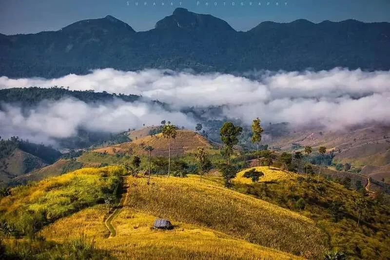
Doi Wao in Nan Province is a scenic mountain viewpoint and natural watershed conservation area located in Ban Doi Tio, Village No. 7, Si Phum Subdistrict, Tha Wang Pha District. The area lies within the wider natural landscape of Nanthaburi National Park and is managed by the Nam Khang Watershed Management Unit. Doi Wao is known for misty mountain views, sunset scenery, hill evergreen forest, and panoramic views over Tha Wang Pha and Pua districts.
Doi Wao is not only a viewpoint but also an important restored watershed area. Parts of the surrounding forest were once degraded, but the watershed management unit has helped restore the area by planting suitable native and highland species such as wild apple, maple, and three-needle pine. Today, the area has regained much of its natural richness and serves as an important learning site for forest restoration in Nan Province.
The route to Doi Wao passes through Hmong highland communities, including Ban Doi Tio and Ban Sop Khun. This gives visitors a chance to experience both mountain landscapes and the cultural atmosphere of highland villages. After reaching the Nam Khang Watershed Management Unit, travelers can continue on foot to the summit viewpoint.
The summit of Doi Wao is one of the most beautiful viewpoints in Tha Wang Pha District. In the cool season, morning mist often covers the valleys, while evenings offer impressive sunset views over layers of mountains. From the high viewpoint, visitors can see the landscapes of Tha Wang Pha District, Pua District, and surrounding mountain ridges of Nan Province.
Doi Wao is also suitable for birdwatching. The hill evergreen forest along the trail provides habitat for highland birds such as red-faced liocichla, long-tailed sibia, yellow-cheeked tit, red-winged shrike-babbler, and long-billed wren-babbler. During winter, migratory birds also visit the area, making it especially rewarding for bird lovers.
The best time to visit Doi Wao is from November to February, when the weather is cool, mist is common, and the trail conditions are suitable for hiking. During the rainy season, the forest becomes greener and more refreshing, but visitors should prepare proper footwear and check weather conditions before traveling.
Doi Wao is ideal for travelers seeking a quiet nature destination away from crowded tourist areas. It offers a peaceful combination of mountain views, forest trails, bird habitats, watershed conservation, and local highland community scenery.
Getting There visitors can travel from Nan town toward Tha Wang Pha District, then continue to Ban Doi Tio in Si Phum Subdistrict and the Nam Khang Watershed Management Unit. From the unit area, visitors continue on foot to the Doi Wao summit. A vehicle suitable for mountain roads is recommended.
| Name | Doi Wao |
| Location | Ban Doi Tio, Village No. 7, Si Phum Subdistrict, Tha Wang Pha District, Nan Province, Thailand |
| Coordinates | 19.1416, 100.6795 |
| Highlights | Misty viewpoint, sunset scenery, hill evergreen forest, and panoramic views of Tha Wang Pha and Pua |
| Distinctive Features | Watershed conservation area, hiking route, and highland bird habitat |
| Travel Information | Travel through Tha Wang Pha District to Ban Doi Tio and Nam Khang Watershed Management Unit, then hike to the summit |
| Current Status | Open as a natural viewpoint and watershed conservation area within Nanthaburi National Park |
| Open Days | Daily |
| Opening Hours | 06:00 – 18:00 |
| Fees | No admission fee |
| Caretaker | Nam Khang Watershed Management Unit and Nanthaburi National Park |
| Main Contact Number | 065-416-8853 |
| Nearby Tourist Attractions | 1. Nanthaburi National Park, about 4 km 2. Ban Doi Tio, about 3 km 3. Ban Sop Khun, about 8 km 4. Tha Wang Pha District, about 28 km 5. Ban Tai Lue Nong Bua, about 35 km |
| Nearby Restaurants | 1. Nanthaburi National Park Welfare Shop, about 4 km 2. Sop Khun Local Restaurant, about 8 km 3. Tha Wang Pha Local Restaurant, about 28 km 4. Ban Tai Lue Coffee Shop, about 35 km 5. Huan Hom Pua, about 45 km |
| Nearby Accommodations | 1. Nanthaburi National Park Camping Ground, about 4 km, Tel. 065-416-8853 2. Nanthaburi National Park Accommodation, about 4 km, Tel. 065-416-8853 3. Accommodation in Tha Wang Pha District, about 28 km 4. Ban Tai Lue Nong Bua Homestay, about 35 km 5. Pua De View Boutique Resort, about 45 km, Tel. 054-718-411 |
Frequently Asked Questions (FAQ)
Q: Where is Doi Wao located?
A: Doi Wao is located at Ban Doi Tio, Village No. 7, Si Phum Subdistrict, Tha Wang Pha District, Nan Province.
Q: What is Doi Wao known for?
A: It is known for misty views, sunset scenery, hill evergreen forest, and views of Tha Wang Pha and Pua districts.
Q: When is the best time to visit Doi Wao?
A: November to February is the best period for cool weather and misty mountain views.
Q: Do visitors need to hike to Doi Wao summit?
A: Visitors can travel by vehicle to the watershed unit area and then hike to the summit viewpoint.
Q: Is Doi Wao suitable for birdwatching?
A: Yes. The hill evergreen forest is home to many highland bird species and migratory birds in winter.
Q: Are there accommodations near Doi Wao?
A: Yes. Camping areas and park accommodation are available at Nanthaburi National Park, with additional lodging in Tha Wang Pha and Pua districts.
 Category: ●Nature and Wildlife
 Group: ●National Parks and Marine Reserves
Last Update : 4 MonthAgo
 Last Update : 4 MonthAgo
 Click to Access the Navigation Map GPS
Doi Wao National Park Map
Recommend

 Art, Culture and Heritage
 Landmarks and Memorials(6)
 Art, Craft Centres, Tradition(6)
 Museums(4)
 Historic Homes and Cities(1)
 Art Gallery(1)
 Educational Places
 Educational Gardens, Farm(1)
 Places of Worship
 Temple(68)
 Church(1)
 Other Sacred Sites(18)
 Research and Development
 Royal Project(2)
 Suburban Living
 Village, Community(13)
 Local Market(1)
National Parks and Marine Reserves(9)
Local Market(1)
National Parks and Marine Reserves(9)
 Mountain (Doi)(6)
 Dam, Reservoir, Lake(16)
 Waterfalls(28)
 Hot Springs(1)
 Caves(11)
 River, Canal(5)
 Other natural attractions(10)
 Entertainment and Agricultural
 Farms, Parks and Ecotourism(4)
 Outdoor and Adventure Activities(2)


