
lovethailand home >Central Travel Attractions >Chachoengsao Travel Attractions >Bang Khla >Pak Nam > Wat Kok Sap
TL;DR: Wat Kok Sap is located at Moo 4, Pak Nam Subdistrict, Bang Khla District, Chachoengsao 24110 (along Khlong Tha Lat), open Open daily, hours 06:00 – 18:00.
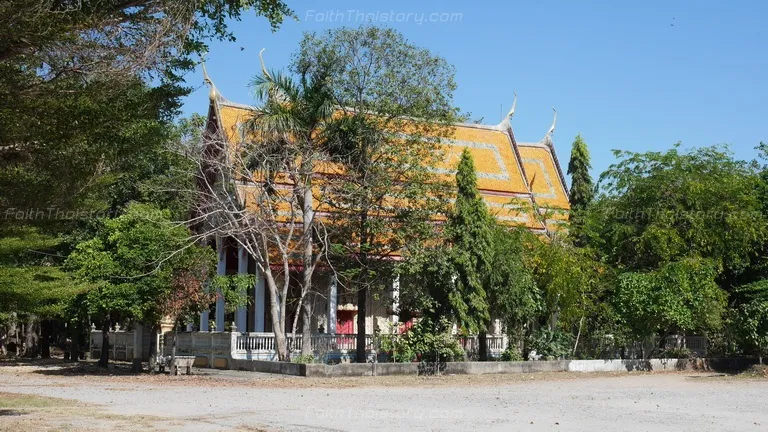
Wat Kok Sap
Open Days: Open daily
Opening Hours: 06:00 – 18:00
Wat Kok Sap (Wat Kok Sap Nai) is a community temple under the Mahanikaya sect, located in Pak Nam Subdistrict, Bang Khla District, Chachoengsao Province. With Khlong Tha Lat running right in front of the temple, the identity of this place is inseparable from its riverside landscape. What looks calm and orderly today was once the community’s “main artery”—a route for travel, trade, and everyday life within the Bang Pakong River basin. As you step inside, the atmosphere feels simple and grounded in the character of a local temple, yet layered with a meaningful blend of history, culture, and archaeology.
Wat Kok Sap was founded on March 13, 1922 (B.E. 2465), led by Phra Phanom Sarn Narin (Hun Phanomyant). The temple was established on land donated earlier in 1919 (B.E. 2462) by Mr. Kli and Mrs. Sai from Phanom Sarakham District. This is not a minor detail: beginning with donated land is a common pattern in the formation of community temples across Thailand, reflecting a tangible relationship between religion, community, and local social capital. After the temple became firmly established, it received royal consecration of its boundary (Wisungkhamsima) on August 18, 1933 (B.E. 2476), with the boundary set at 40 meters wide and 80 meters long. This was not merely ceremonial—it formally confirmed the status of the ubosot (ordination hall) and the temple’s sacred precinct under the Sangha regulations, demonstrating the temple’s recognized role within the community.
As a riverside temple, Wat Kok Sap is inevitably connected to the Bang Pakong River basin. The Bang Pakong is a major river system in eastern Thailand, linking agricultural land, waterfront communities, and diverse natural resources from its upper reaches to the Gulf of Thailand. Networks of natural canals and later manmade waterways once served as transport corridors for goods such as rice, fish, shrimp, fruit, and Bang Khla’s orchard produce, as well as the primary means of travel before roads reached every subdistrict. Khlong Tha Lat, directly in front of the temple, is therefore not simply a “backdrop,” but a piece of infrastructure that sustained the community—making the temple accessible, enabling merit-making events, and supporting the movement of relatives and faith networks who could actually arrive by water.
The temple becomes even more distinctive when viewed through an archaeological lens and material evidence. In the area of Khlong Tha Lat in front of the temple, a boat wreck was reportedly excavated along with a cannon and multiple antique household or utilitarian items. These finds were examined and registered by relevant Fine Arts Department offices in the region and were estimated to date to the early Rattanakosin period, roughly during the reigns of King Rama IV–VI. This was a time of significant transformation for Siam in governance, economy, military structure, and foreign relations. The presence of a “boat + cannon” in a community waterway opens several layers of historical inquiry. Without rushing to attribute ownership to any particular side, it clearly indicates that waterways in the Bang Pakong basin carried both “strategic significance” and “economic importance” at the same time.
To understand the archaeological depth of a boat wreck discovery in Khlong Tha Lat, it helps to view it within the broader framework of underwater cultural heritage in Thailand. Underwater artifacts commonly appear in places that once functioned as navigation routes, trading corridors, cargo stopovers, or sites of military activity. Over time, sedimentation, shifts in water flow, dredging, and erosion can reveal objects that had remained hidden beneath the water. The boat wreck and cannon discovery in Khlong Tha Lat resembles other Thai cases that surfaced during dredging or water-management works aimed at reducing flooding and dealing with siltation. In other words, these objects did not “surface by themselves”; they became visible when people intervened in the water system—especially during dredging that deepened or improved drainage. Seen this way, Wat Kok Sap becomes a site where a community’s religious landscape intersects with underwater historical evidence that reflects real waterway use in the past.
Local accounts from earlier reporting describe how the boat wreck and cannon appeared during dredging operations intended to address flooding, drawing many residents to witness the exposed objects. The image of people gathering around the discovery point is not unlike “watching history emerge from the water” in real time. This matches the nature of river-basin archaeology, which often enters public awareness through a sudden event before moving into academic procedures such as verification, registration, relocation, conservation, and database documentation. Importantly, even when local beliefs or legends arise, archaeological work relies on evidence such as form, material, manufacturing techniques, traces of use, and sediment context to assess age and likelihood as accurately as possible. The estimated date range of Rama IV–VI also invites a view of Siam in the reform era, when water transport still mattered greatly alongside the rise of roads and new transportation systems.
Within that early-to-mid Rattanakosin timeframe, the idea of “a boat and a cannon” within a waterway network leads to a structural understanding: in the past, river basins were not only food-producing landscapes but also zones for controlling movement of resources and ensuring security. Heavy weaponry such as a cannon in a water context suggests some form of security management or route protection at certain moments in history—whether against banditry, for convoy protection, or for temporary stationing during tense situations. It also reflects the technology of the era, as cannons require metallurgical knowledge, gunpowder management, and organized deployment—elements connected to state structures and armed forces of the same period.
Connecting this to the Bang Pakong River basin in historical terms also highlights Bang Khla District as a “middle corridor” between Chachoengsao town, orchard zones, and routes toward the Gulf of Thailand. Riverside communities like Bang Khla thus functioned as both market towns and orchard landscapes. The area is known for mango groves, coconut plantations, seasonal fruit orchards, and freshwater-to-brackish fisheries in certain periods, creating lively exchange networks in earlier times. When there are markets, piers, rafts, and floating platforms, waterways become even more central to everyday life—and where waterways matter, it becomes reasonable that material traces remain in the river, whether through accidents, disposal, sinking, or abandonment after repairs as time passes.
On another level, the temple carries tangible local devotion through veneration of Luang Pho Sui and Luang Pho Ngern, former abbots, especially Luang Pho Ngern Chanthasaro, who is widely revered in Bang Khla. Inside the temple, a mondop (pavilion) enshrines their statues for worship and remembrance. Community stories often speak of exceptional spiritual prowess and compassionate charisma, including invulnerability, potent speech (believed to be sacred and effective), and the ability to “unlock” even a locked ubosot. One enduring phrase remembered by locals is that those who sincerely venerate him would never starve. From an anthropological perspective, beliefs like this function as “emotional capital” for a community—affirming that in difficult times there is refuge and hope—which is why many community temples are not only ritual spaces but also centers of social and emotional security.
With the temple situated beside Khlong Tha Lat, the “landscape of devotion” naturally merges with the “river-basin landscape.” Making merit while seeing the water in front of the temple allows visitors to sense life’s continuity in two dimensions at once: the spiritual dimension and the livelihood dimension. It is not surprising that many riverside temples hold legends and material traces connected to waterways, because rivers are both working spaces and story spaces. When archaeological objects such as a boat wreck and cannon appear, community perception is not merely “old stuff,” but “evidence that this land and water have truly witnessed real events.”
For visitors, Wat Kok Sap is suitable for worship, merit-making, and place-based learning, especially for those who enjoy local history that can be “read from the site itself.” A visit can begin at the ubosot and the Wisungkhamsima boundary to understand the temple’s sacred core, then continue to the mondop to worship and grasp the community’s devotional lineage, before turning outward to Khlong Tha Lat to connect the narrative to the real geography. Look deeper, and the water flowing in front of the temple signals more than tranquility: it points to orchard economies, transport routes for goods, and plausible historical conditions that could have placed a boat and a cannon in this canal at a specific moment in the past.
Getting There From Chachoengsao town, head toward Bang Khla District, then continue into Pak Nam Subdistrict to the area along Khlong Tha Lat in front of the temple. Traveling by private car is the most convenient option, with parking available within the temple grounds in designated areas. For a smoother trip, set your destination as “Wat Kok Sap (Wat Kok Sap Nai), Pak Nam Subdistrict, Bang Khla District,” and check the route before departure—especially on weekends, when Bang Khla can be busy with visitors heading to the floating market and riverside restaurants.
With all of these elements, Wat Kok Sap stands out among typical subdistrict community temples due to the strength of its “core narrative.” It has clear founding and consecration history, a former abbot whose devotion evolved into a lasting cultural symbol, and archaeological material evidence in the waterway in front of the temple that connects directly to the Bang Pakong River basin context. If you are looking for a temple that offers more than a quick stop, this place provides an opportunity to “read the locality through the water,” and to see how riverside community life continues to shape the meaning of a religious site today.
| Place Name | Wat Kok Sap (Wat Kok Sap Nai) |
| Address | Moo 4, Pak Nam Subdistrict, Bang Khla District, Chachoengsao 24110 (along Khlong Tha Lat) |
| Place Summary | A riverside community temple under the Mahanikaya sect, founded in 1922 (B.E. 2465) and granted Wisungkhamsima in 1933 (B.E. 2476). Notable for the mondop of Luang Pho Ngern Chanthasaro and reports of a boat wreck and cannon discovered in Khlong Tha Lat in front of the temple. |
| Highlights | Mondop enshrining statues of Luang Pho Sui and Luang Pho Ngern Chanthasaro; strong local devotional tradition; underwater heritage narrative (boat wreck and cannon) linked to the Bang Pakong River basin. |
| Period | Temple founded in the Rattanakosin era (1922). Reported underwater finds estimated to the early-to-mid Rattanakosin period (Rama IV–VI). |
| Key Evidence | Wisungkhamsima boundary (40 m x 80 m). Reports of a boat wreck, cannon, and antique items found in Khlong Tha Lat in front of the temple. |
| Name Origin | The name “Kok Sap” aligns with wetland landscapes and sedge (kok) vegetation common in river-basin areas, preserved as a local place name over time. |
| Current Steward / Abbot (Latest) | Phra Baidika Kai Katapunyo |
| Travel | Travel by car from Chachoengsao toward Bang Khla District, then into Pak Nam Subdistrict to the riverside area along Khlong Tha Lat. On-site parking available. |
| Current Status | Open for worship and merit-making. |
| Nearby Tourist Attractions (Road Distance) | 1) Bang Khla Floating Market – 6 km 2) Wat Pho Bang Khla – 7 km 3) Bang Pakong River (Bang Khla riverside viewpoint/restaurant zone) – 6 km 4) Wat Saman Rattanaram – 22 km 5) Ban Mai 100-Year Market (Chachoengsao old town area) – 28 km |
| Popular Restaurants Nearby (Road Distance + Phone) | 1) Kor Kung Pao (Bang Khla Floating Market) – 6 km. Tel. 081-861-1655 2) Kung Pao Talay Pao Restaurant – 7 km. Tel. 099-257-0634 3) Rommai Saitarn – 8 km. Tel. 038-542-794 4) Pae Kung Samerng – 11 km. Tel. 081-410-2498 5) Thao Kae Chue (Bang Khla area) – 9 km. Tel. 081-305-0868 |
| Popular Accommodations Nearby (Road Distance + Phone) | 1) Bang Khla Resort – 3 km. Tel. 085-224-4139 2) Tala Bangkla Riviera – 12 km. Tel. 062-323-7424 3) Yenjit Resort – 24 km. Tel. 086-803-2070 4) Tamarind@Bangkhla – 10 km. Tel. 065-563-2392 5) Blue Ozone Resort & Spa – 14 km. Tel. 081-611-1144 |
Frequently Asked Questions (FAQ)
Q: When was Wat Kok Sap founded?
A: The temple was founded on March 13, 1922 (B.E. 2465), led by Phra Phanom Sarn Narin (Hun Phanomyant), and the land was donated in 1919 (B.E. 2462).
Q: When did Wat Kok Sap receive Wisungkhamsima?
A: The temple received Wisungkhamsima on August 18, 1933 (B.E. 2476), with the boundary measuring 40 meters by 80 meters.
Q: Why is Luang Pho Ngern Chanthasaro significant at Wat Kok Sap?
A: Luang Pho Ngern Chanthasaro was a former abbot highly revered by the Bang Khla community. The temple has a mondop enshrining his statue for worship and remembrance.
Q: What is the story behind the boat wreck and cannon found in front of the temple?
A: A boat wreck, a cannon, and several antique items were reportedly found in Khlong Tha Lat in front of the temple. The finds were examined and registered by regional cultural heritage authorities and estimated to date to the early-to-mid Rattanakosin period (Rama IV–VI).
Q: How can I plan a worthwhile cultural day trip in Bang Khla?
A: Start by worshipping and learning the story of Wat Kok Sap, then visit Bang Khla Floating Market for riverside lifestyle, enjoy grilled river prawns at nearby restaurants, and end with key Chachoengsao sites such as Wat Saman Rattanaram or the old-town area.
Q: What etiquette should visitors follow at Wat Kok Sap?
A: Dress respectfully, keep quiet within sacred areas, avoid disturbing ceremonies, and be considerate when taking photos so as not to interrupt worshippers.
 Category: ●Places of Worship
 Group: ●Temple
Last Update : 6 MonthAgo
 Last Update : 6 MonthAgo
 Click to Access the Navigation Map GPS
Wat Kok Sap Map
Recommend

 Art, Culture and Heritage
 Historical Sites and Monuments(3)
 Landmarks and Memorials(4)
 Royal Palace(1)
 Art, Craft Centres, Tradition(10)
 Museums(2)
 Historic Homes and Cities(1)
 Educational Places
 Museum for Study(1)
 Library(1)
 Educational Gardens, Farm(2)
Temple(50)
Educational Gardens, Farm(2)
Temple(50)
 Mosque(2)
 Other Sacred Sites(7)
 Research and Development
 Royal Project(4)
 Suburban Living
 Village, Community(5)
 Local Market(4)
 Floating Market(1)
 Nature and Wildlife
 National Parks and Marine Reserves(2)
 Mountain (Doi)(1)
 Dam, Reservoir, Lake(6)
 Waterfalls(1)
 Caves(1)
 River, Canal(2)
 Bays and Beaches(1)
 Islands(2)
 Other natural attractions(2)
 Entertainment and Agricultural
 Zoos and Aquariums(1)
 Animal camps and shows(1)
 Farms, Parks and Ecotourism(6)
 Spas and Wellness
 Spas and Wellness(1)
 Travel Articles, Recipes
 Travel Review, Food Review(3)


