
lovethailand home >Northeastern Travel Attractions >Yasothon Travel Attractions >Muang Yasothon >Doet > Yang Dam
TL;DR: Yang Dam is located at Ban Mai Chumphon, Doet Subdistrict, Mueang Yasothon District, Yasothon Province, open Daily, hours 08.00 – 17.00.

Yang Dam
Open Days: Daily
Opening Hours: 08.00 – 17.00
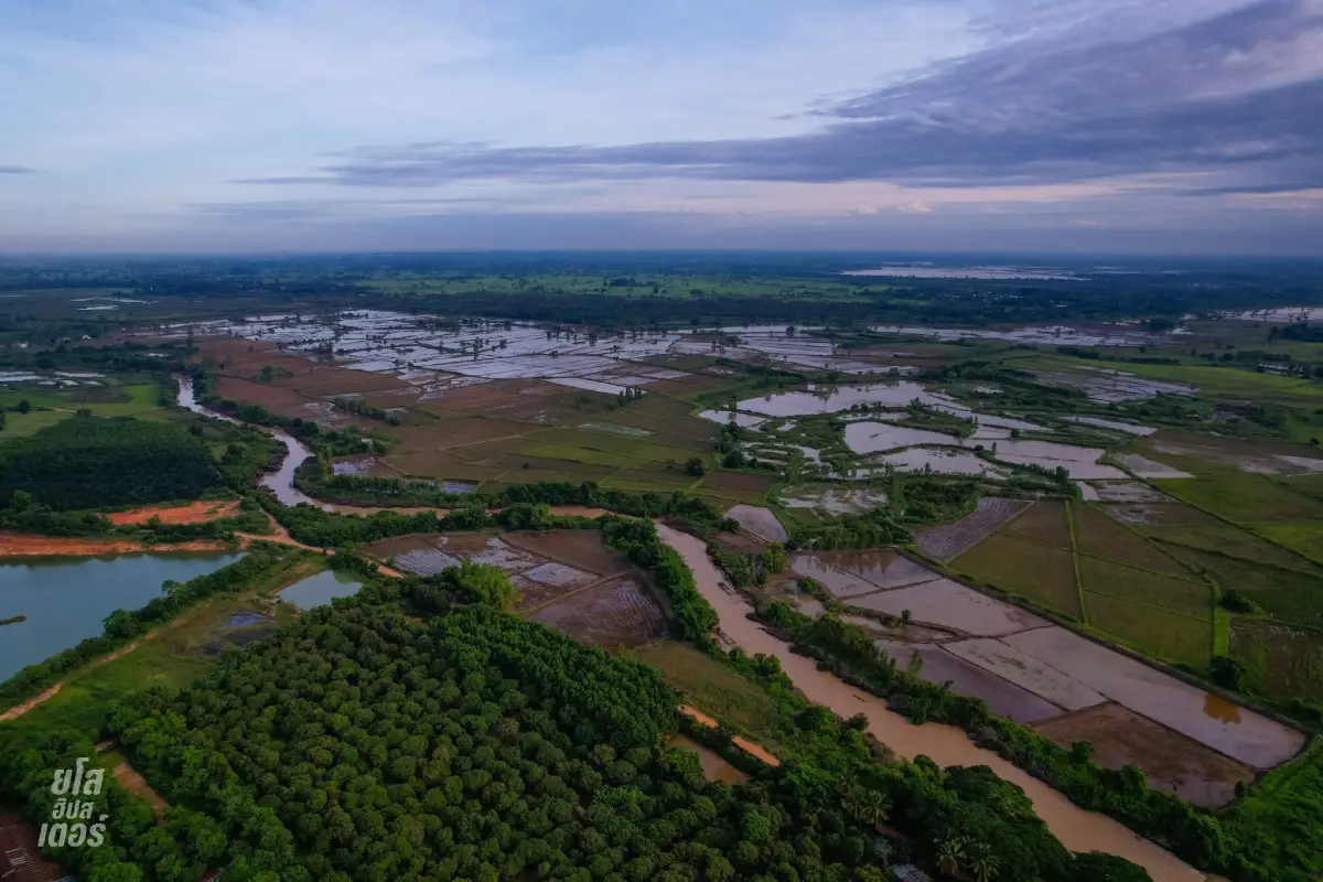
Lam Nam Yang Overflow Weir at Ban Mai Chumphon in Yasothon Province is a small but meaningful nature and water-management site in Doet Subdistrict, Mueang Yasothon District. Located along Lam Nam Yang, the weir is closely connected with rural life, agricultural land, riverbank ecology, water monitoring, and the seasonal rhythm of northeastern Thailand. It is not a large commercial tourist attraction, but it offers a clear view of how a local stream, a rural community, farming areas, and water infrastructure are linked in everyday life.
Lam Nam Yang is an important tributary of the Chi River. It flows through Doet Subdistrict before continuing toward the Chi River. Because of this, the stream plays an important role in local agriculture, drainage, flood monitoring, and the natural landscape of communities along its banks. Ban Mai Chumphon is one of the important riverside communities in this area, and the overflow weir allows visitors to see the relationship between water, land, and rural life in a practical and visible way.
An overflow weir is a water-control structure designed to allow water to pass over it when the water level rises. It is different from a large dam. Rather than storing a huge volume of water, a weir helps slow the flow, raise the local water level, maintain moisture in the surrounding area, and support water use in nearby agricultural landscapes. In northeastern Thailand, where the wet and dry seasons create strong changes in water availability, weirs are important local infrastructure.
The Ban Mai Chumphon area has also been connected with provincial water monitoring. The bridge across Lam Nam Yang at Ban Mai Chumphon and the water-level monitoring point near Tha Kut Noi monastic residence are important points before water from Lam Nam Yang enters wider areas of Mueang Yasothon District. This gives the site significance beyond sightseeing. It is part of a real river system that affects farmland, local communities, and water-management decisions during the rainy season.
The atmosphere around the weir is simple and rural. Visitors can see the stream, the banks, nearby agricultural fields, local roads, trees along the water, and the open landscape of rural Yasothon. The value of the place comes from its authenticity. It is not a staged attraction. It is a working riverside area where water, agriculture, and community life meet. For travelers who enjoy quiet places, rural scenery, or documentary-style photography, the weir offers a calm and meaningful stop.
During normal water conditions, Lam Nam Yang Overflow Weir is suitable for observing the stream, watching water pass through the weir, viewing the riverbank landscape, and taking photographs of rural scenery. Morning and late afternoon are the most pleasant times, with softer light and less heat. The sound of flowing water adds a relaxing atmosphere, making the site suitable for a short nature stop on a route around Mueang Yasothon District.
During the rainy season, the character of Lam Nam Yang changes significantly. Water levels can rise, the current can become stronger, and nearby low-lying agricultural areas may be affected by overflow. Visitors should treat the rainy season with caution. They should stay away from strong currents, avoid slippery wet surfaces, keep children under close supervision, and follow local water-level information before visiting. The rainy season shows the power of the stream, but it must be observed safely.
During the dry season, the site shows another side of Isan water management. Water levels may drop, exposing more of the riverbank and shallow areas. This makes the role of the weir easier to understand because the structure helps retain water in the stream area. The dry-season landscape helps visitors see why small-scale water infrastructure matters to farming communities that must adapt to both water shortage and seasonal abundance.
The weir area is also useful for understanding riverbank ecology. A stream is not only a watercourse. It supports plants, fish, insects, birds, and small animals. Trees along the bank help reduce erosion, provide shade, and create habitat. Shallow water and slower-flowing areas support aquatic life. The natural edge of the stream is part of the local ecosystem, so visitors should avoid littering, damaging riverbank plants, or disturbing wildlife.
For local residents, Lam Nam Yang is directly connected with farming. Many areas along the stream are used for rice fields and agriculture. When water is sufficient, crops benefit. When water levels rise too high, farmland can be affected. This relationship makes the weir and the stream important to household livelihood. A visit to the site helps travelers understand how rural communities must live with both the benefits and risks of water.
The site also reflects the work of water-related agencies in Yasothon. Irrigation and local agencies monitor water levels, coordinate during periods of heavy rain, and help manage information related to flood risk. Since Ban Mai Chumphon is one of the important points on Lam Nam Yang, the area has practical relevance to provincial water monitoring and community preparedness.
For photography, the weir offers documentary-style subjects: flowing water, rural riverbanks, agricultural land, open sky, river structures, and local community routes. The best images often come from simple compositions rather than dramatic staging. Morning and afternoon light gives the water and surrounding landscape more depth. Visitors should avoid standing on dangerous wet surfaces or climbing onto the weir structure for photographs.
Photography should be done respectfully. The area is part of a working community landscape. Visitors should not block local routes, disturb residents, enter private land, or take close photographs of local people without permission. The best way to photograph the site is to record the real atmosphere of the water and community while keeping a safe distance from the current.
For families, Lam Nam Yang Overflow Weir can be an outdoor learning point. Children can learn what a weir is, why water-control structures are built, where a stream flows, how riverbanks support life, and why water can be both a resource and a hazard. Parents should keep children away from the water edge and explain safety rules clearly, especially during the rainy season.
For students and study groups, the site is useful for learning about local water management, community-level infrastructure, agricultural water use, river ecology, seasonal flooding, and flood-risk monitoring. Unlike classroom diagrams, this place allows learners to see a real stream and a real rural landscape where water management affects people directly.
For international travelers, the weir provides a grounded view of rural northeastern Thailand. Yasothon is often known for the Rocket Festival, Buddhist temples, and Isan culture, but the Ban Mai Chumphon weir shows another layer: water systems, farming, riverbank communities, and local infrastructure. It helps foreign visitors understand that streams and small weirs are important parts of rural Thai life.
Lam Nam Yang Overflow Weir is not a facility-heavy attraction. Visitors should prepare drinking water, sun protection, and stable footwear. They should keep the area clean and avoid leaving waste near the stream. The best visit is short, calm, and observant. The site can be combined easily with nearby destinations in and around Yasothon city.
Getting There is most convenient by private car. From Yasothon city, travel toward Doet Subdistrict in Mueang Yasothon District and continue to Ban Mai Chumphon, a riverside community along Lam Nam Yang. The route connects with local roads around Mueang Yasothon and the direction toward Roi Et. During the rainy season, travelers should check water conditions before visiting and avoid entering flooded or unstable roadside areas.
The recommended visiting hours are 08.00 to 17.00. Morning is suitable for soft light, cooler air, and quiet river scenery. Afternoon works well for a short stop before returning to Yasothon city. The cool season and clear-weather days are the most comfortable for general visits. During the rainy season, the site can be visually powerful, but safety must come first because water levels and currents can change quickly.
There is no admission fee for general visits. Visitors can stop to observe the stream, study the weir, and enjoy the riverside atmosphere during appropriate hours. Any expenses are mainly personal travel costs or food and drink from nearby routes. Since the site is part of a rural community and water-management landscape, visitors should not litter, enter unsafe water areas, damage the weir, or disturb local residents.
Facilities are basic and reflect the site’s rural context. Visitors can access the area by road, observe the stream from appropriate community routes, and continue to restaurants and accommodations in Yasothon city or nearby Samran Subdistrict. Those traveling with children, elderly visitors, or study groups should plan the route and timing carefully.
A practical travel route can begin at the Lam Nam Yang Overflow Weir in the morning, then continue to Yasothon city for Phaya Thaen Public Park, the Toad Museum, Wat Mahathat Yasothon, Ban Sing Tha Old Quarter, Bung Noi Bung Yai Public Park, and Phra That Kong Khao Noi. This combination gives one trip a balance of water landscape, rural life, local history, religion, and city landmarks.
From a cultural perspective, the weir shows how Isan communities are closely connected with water. Although northeastern Thailand is often associated with drought, water remains central to farming, settlement, drainage, flood preparedness, and community stability. A modest riverside structure like a weir can tell a large story about how people live with seasonal change.
Keeping the weir and stream area clean is important for both tourism and local life. Plastic waste, food scraps, and discarded items can affect water quality, riverbank ecology, and the appearance of the area. Visitors can help by taking waste back with them, avoiding pollution, and leaving the riverbank undisturbed. Responsible behavior keeps the site useful and pleasant for both local people and future visitors.
In summary, Lam Nam Yang Overflow Weir at Ban Mai Chumphon in Yasothon is a small but valuable natural and community learning site. Its highlights include the Lam Nam Yang riverside setting, the overflow weir, rural agricultural scenery, water-level monitoring significance, riverbank ecology, and the connection between water, farming, and community life. It is suitable for travelers who want a quiet nature stop, a practical lesson in local water management, and a deeper view of rural Yasothon before continuing to nearby attractions in the city.
| Name | Lam Nam Yang Overflow Weir, Ban Mai Chumphon |
| Type | Natural Attraction, Riverside Viewpoint, Overflow Weir, Community Water Learning Site, And Lam Nam Yang Landscape |
| Location | Ban Mai Chumphon, Doet Subdistrict, Mueang Yasothon District, Yasothon Province |
| Address Summary | Lam Nam Yang riverside area, Ban Mai Chumphon, Doet Subdistrict, Mueang Yasothon District, Yasothon 35000, Thailand |
| Highlights | Overflow weir on Lam Nam Yang, rural riverside atmosphere, agricultural riverbank scenery, local water-management learning point, connection with the Chi River system, and a quiet nature stop near Yasothon city |
| Area Significance | A riverside area connected with agricultural water use, stream-flow slowing, water-level monitoring, and the relationship between Lam Nam Yang, local communities, and farming areas in Mueang Yasothon District |
| Stream Characteristics | Lam Nam Yang is a tributary of the Chi River. It flows through Doet Subdistrict before entering the Chi River system and plays an important role in farming areas, riverside communities, and rainy-season water monitoring. |
| Suitable Activities | Riverside observation, overflow weir viewing, nature photography, community water-management study, learning about seasonal flooding and dry-season water conditions, viewing agricultural riverbanks, and connecting the trip with Yasothon city attractions |
| Travel Information | From Yasothon city, travel to Doet Subdistrict in Mueang Yasothon District and continue to Ban Mai Chumphon, a riverside community along Lam Nam Yang. A private car is the most convenient option. |
| Current Status | Open as a riverside nature stop and local water-learning area. Ban Mai Chumphon remains an important point for monitoring Lam Nam Yang water conditions during the rainy season. |
| Open Days | Daily |
| Opening Hours / Recommended Visiting Hours | 08.00 – 17.00 |
| Fees | No admission fee for general visits |
| Facilities | Community road access, riverside observation points along local routes, riverbank areas for viewing the weir, nearby food options along local routes, and accommodations in Yasothon city or Samran Subdistrict |
| Main Areas / Zones | Overflow Weir Zone Lam Nam Yang Stream Zone Riverbank Observation Zone Ban Mai Chumphon Bridge Zone Water-Level Monitoring And Flood-Watch Zone Agricultural Riverbank Zone Ban Mai Chumphon Community Route Zone Yasothon City Connection Route Zone |
| Caretaker / Related Agencies | Yasothon Irrigation Project, provincial water-related agencies, Mueang Yasothon District, Ban Mai Chumphon community leaders, and local agencies in Doet Subdistrict |
| Contact Numbers | Yasothon Irrigation Project, Tel. 045-711487 Yasothon Municipality, Tel. 045-712252 Yasothon Provincial Administrative Organization, Tel. 045-711642 |
| Safety Notes | During the rainy season, check water conditions before visiting. Avoid strong currents, slippery wet surfaces, climbing on the weir structure, and allowing children near the water without close supervision. |
| Nearby Tourist Attractions | 1. Ban Mai Chumphon Bridge Across Lam Nam Yang, about 1 km 2. Ban Chiang Wang Cattle And Buffalo Market, about 13 km 3. Phaya Thaen Public Park, about 16 km 4. Toad Museum, about 16 km 5. Wat Mahathat Yasothon, about 17 km 6. Ban Sing Tha Old Quarter, about 18 km 7. Bung Noi Bung Yai Public Park, about 18 km 8. Phra That Kong Khao Noi, about 22 km |
| Nearby Restaurants | 1. Local Restaurants In Doet Subdistrict And Ban Mai Chumphon, about 1 km 2. Chao Samran Restaurant, Ban Samran Yasothon, about 11 km, Tel. 087-0101955 3. Thai House Boat Noodles Yasothon, about 15 km, Tel. 083-1015387 4. Ban Khun Ya Yasothon, about 16 km, Tel. 045-721141-2 5. Rasniyom Boat Noodles Yasothon, about 16 km, Tel. 098-7997269 6. Samrit Restaurant Yasothon, about 17 km, Tel. 086-2492508 7. Rai Hug Kuk Yasothon, about 18 km, Tel. 099-2896554, 061-9501942 |
| Nearby Accommodations | 1. PK Garden Hotel, about 12 km, Tel. 045-711456 2. The Green Park Grand Hotel Yasothon, about 15 km, Tel. 045-714700-1 3. JP Emerald Hotel Yasothon, about 16 km, Tel. 045-714456 4. The Zen Hotel Yasothon, about 16 km, Tel. 045-711455 5. BM Grand Hotel Yasothon, about 17 km, Tel. 045-712333 6. RP City Hotel, about 17 km, Tel. 045-711648 7. Botanic Garden Hotel, about 18 km, Tel. 045-712064 |
Frequently Asked Questions (FAQ)
Q: Where is Lam Nam Yang Overflow Weir at Ban Mai Chumphon located?
A: It is located in the Lam Nam Yang riverside area at Ban Mai Chumphon, Doet Subdistrict, Mueang Yasothon District, Yasothon Province. The area is connected with farming life and provincial water monitoring.
Q: What is the highlight of this place?
A: The highlight is the overflow weir on Lam Nam Yang, rural riverside scenery, agricultural riverbanks, and the opportunity to learn about local water management, seasonal flooding, drought, and community life along the stream.
Q: What are the opening hours?
A: The site is open daily from 08.00 to 17.00. Morning and afternoon are suitable for riverside viewing, photography, and observing the overflow weir.
Q: Is there an admission fee?
A: There is no admission fee for general visits. Visitors can stop to observe the riverside atmosphere and learn about the weir during appropriate hours.
Q: Why is Lam Nam Yang important?
A: Lam Nam Yang is a tributary of the Chi River. It flows through Doet Subdistrict before entering the Chi River system and plays an important role in farming areas, riverside communities, and rainy-season water monitoring.
Q: What should visitors be careful about?
A: Visitors should avoid strong currents, slippery wet surfaces, and climbing on the weir structure. Children should be supervised closely, especially during the rainy season when water levels can change quickly.
Q: How can travelers get there?
A: From Yasothon city, travel to Doet Subdistrict in Mueang Yasothon District and continue to Ban Mai Chumphon along Lam Nam Yang. A private car is the most convenient option.
Q: What nearby attractions can be visited on the same trip?
A: Nearby attractions include Ban Chiang Wang Cattle And Buffalo Market, Phaya Thaen Public Park, the Toad Museum, Wat Mahathat Yasothon, Ban Sing Tha Old Quarter, Bung Noi Bung Yai Public Park, and Phra That Kong Khao Noi.
 Category: ●Nature and Wildlife
 Group: ●Dam, Reservoir, Lake
Last Update : 1 MonthAgo
 Last Update : 1 MonthAgo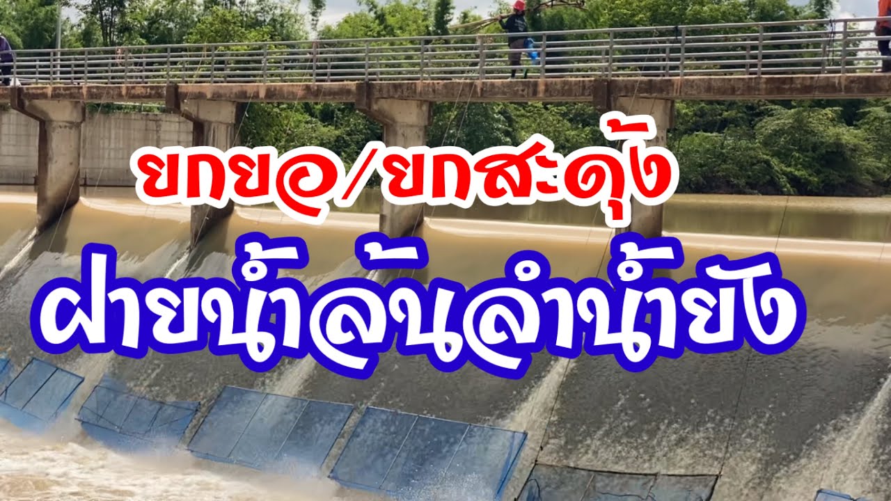
 Click to Access the Navigation Map GPS
 Art, Culture and Heritage
 Historical Sites and Monuments(6)
 Landmarks and Memorials(1)
 Art, Craft Centres, Tradition(4)
 Museums(1)
 Historic Homes and Cities(1)
 Places of Worship
 Temple(22)
 Church(1)
 Other Sacred Sites(9)
 Research and Development
 Royal Project(2)
 Suburban Living
 Village, Community(3)
 Local Market(1)
 National Parks and Marine Reserves(2)
 Mountain (Doi)(2)
Dam, Reservoir, Lake(7)
Mountain (Doi)(2)
Dam, Reservoir, Lake(7)
 River, Canal(2)
 Bays and Beaches(1)
 Other natural attractions(2)
 Entertainment and Agricultural
 Farms, Parks and Ecotourism(1)


