
lovethailand home >Northeastern Travel Attractions >Yasothon Travel Attractions >Maha Chana Chai >Hua Muang > Hat Yao Ban Nong Bua
TL;DR: Hat Yao Ban Nong Bua is located at Ban Nong Bua And Ban Kut Phan Khiao, Hua Mueang Subdistrict, Maha Chana Chai District, Yasothon Province, open Daily, hours 24 Hours.

Hat Yao Ban Nong Bua
Open Days: Daily
Opening Hours: 24 Hours
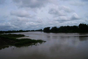
Hat Yao Ban Nong Bua And Ban Kut Phan Khiao in Yasothon Province is a seasonal sandbank and riverside beach area along the Chi River, located around Ban Nong Bua and Ban Kut Phan Khiao in Hua Mueang Subdistrict, Maha Chana Chai District. The beach-like sandy area is formed naturally by riverbank erosion and sediment deposition. It becomes clearly visible during the hot season or in years when the Chi River water level is not high. This makes the place a seasonal nature attraction rather than a permanent beach. It is suitable for evening relaxation, riverside viewing, photography, and learning about the natural relationship between the Chi River and local communities in Maha Chana Chai.
The main character of Hat Yao Ban Nong Bua and Ban Kut Phan Khiao is that it is a river sandbank, not a seaside beach and not a fixed landscape that looks the same throughout the year. Its appearance depends on the water level of the Chi River, rainfall, seasonal flow, and changes along the riverbank. During the hot season or when the river level is low, the sandy surface and small dunes appear along the river, creating an open natural space for walking, sitting, resting, and enjoying the riverside atmosphere.
The place is interesting because it shows how the Chi River shapes the land around it. Water erodes the riverbank, carries sand, and deposits sediment in certain areas, forming a seasonal sandy beach. This natural process reflects the geography of riverside communities in northeastern Thailand. The Chi River is not only a waterway passing through Yasothon. It also shapes riverbanks, supports farming areas, provides fishing grounds, and creates temporary recreation spaces such as this sandbank.
Hat Yao is especially suitable for visiting in the evening. The sunlight becomes softer, the riverside air feels more comfortable, and the atmosphere is better for slow relaxation. Visitors can sit near the river, look along the sandy bank, take photographs of the water and sky, or walk carefully on stable sand areas. Evening light also gives the river surface and sandbank a warmer tone, making the place more attractive for photography and quiet rest.
Ban Nong Bua and Ban Kut Phan Khiao are riverside communities closely connected with the Chi River. The seasonal sandbank gives local people a natural riverside area for rest and community use when conditions are suitable. Its simplicity is part of its charm. The site is not defined by large buildings or commercial facilities, but by the river itself. Visitors can experience a real local landscape of village life, water, riverbank, sand, and rural scenery in one place.
Because the sandbank appears according to river conditions, travelers should understand that the beach may be wide in some periods and partly or fully covered by water at other times. This is not a weakness of the destination. It is the natural identity of a river attraction. Visitors who specifically want to see the sandbank should plan for the hot season or a low-water period. When the water is high, the place can still offer riverside scenery, but the sandy beach may not be clearly visible.
The hot season is the best time to see Hat Yao Ban Nong Bua and Ban Kut Phan Khiao because the sand and small dunes are more likely to appear clearly. The lower water level reveals the long sandy area along the riverbank, making it suitable for viewing, walking, and photography. During the rainy season, visitors should be more cautious. The Chi River may rise, the current may become stronger, and riverbank areas may be wet or slippery. In that period, viewing from a safe distance is the better choice.
Although the area is accessible as a natural open space, safety must always come first. Visitors should not enter the water in unknown areas, should not go near strong currents, and should avoid unstable or slippery riverbanks. Children should be supervised closely at all times. The Chi River is a major river, and its depth, current, and bank condition can change with the season. A safe visit should focus on viewing, resting, and walking only in stable areas.
Suitable activities include riverside viewing, walking on the sandbank when it is visible, nature photography, evening relaxation, small picnics, and learning about river geography. Photographers will find a different kind of Yasothon scenery here: river water, sand, sky, riverbank, and rural communities in one frame. These images show the province as a place shaped not only by fields and festivals, but also by the movement of a large river.
The best time for photography is early morning or late afternoon, especially late afternoon when the place is most suitable for relaxation. Recommended photo angles include the long sandy riverbank, reflections on the Chi River, the river edge with trees, and the rural atmosphere of the nearby communities. Visitors should respect local privacy, avoid close-up photos of residents without permission, and avoid entering houses, fields, or private areas.
Hat Yao is connected with Kut Phan Khiao, a nearby community water source in Ban Kut Phan Khiao, Moo 5 and Moo 11 of Hua Mueang Subdistrict. Together, these places show the importance of water to the community. Kut Phan Khiao is connected with agriculture, fishing, and local activities, while Hat Yao shows a seasonal sandy riverside landscape. Visiting both places gives travelers a clearer view of how water supports local life in Hua Mueang Subdistrict.
Ban Kut Phan Khiao and Ban Nong Bua still retain a rural riverside atmosphere. Visitors should travel politely and respect the community. Drive slowly in village areas, avoid blocking local roads, keep noise low, and take all trash back with you. Small community attractions remain pleasant when visitors treat the place with care and allow local residents to continue their daily life normally.
Hat Yao is best visited as part of a Maha Chana Chai route rather than as a full-day single destination. The main activities are riverside viewing, resting, and seasonal sandbank photography. Visitors may spend 30 to 60 minutes in the evening, then continue to a restaurant or accommodation in Maha Chana Chai. With more time, the route can include Wat Fa Yat, Kut Phan Khiao, the Antiquities Museum at Ban Song Pueai, and the Dong Mueang Toei archaeological site.
Wat Fa Yat is one of the nearby attractions that fits well with Hat Yao. It is located in Maha Chana Chai District and is connected with the cultural memory of communities in the Chi River basin. A route that begins with the river landscape and continues to a local temple gives travelers both natural scenery and cultural context.
The Antiquities Museum at Ban Song Pueai and Dong Mueang Toei archaeological site add historical depth to the route. The museum preserves local antiquities connected with ancient settlement in the area, while Dong Mueang Toei is an important archaeological site with evidence of old communities and ancient cultural influence. Combining these places with Hat Yao allows visitors to see nature, community life, and local history in one trip.
As a natural riverside feature, Hat Yao shows how the landscape changes with the season. When water levels drop, sand and small dunes appear. When the river rises, the water covers more of the bank. This seasonal pattern makes the destination dynamic. Travelers who appreciate natural processes will find this changing character meaningful because it shows the real behavior of a major river rather than a fixed tourist scene.
Families can visit Hat Yao when the sandbank is visible and conditions are safe, but children must be supervised closely near the water. River sand can be soft, slippery, or uneven in some spots, especially after rain or near the waterline. Families should choose dry, stable areas away from the current for resting. Safety should be considered more important than getting close to the water.
For elderly visitors, Hat Yao is best enjoyed as a riverside viewing stop rather than a long walk on sand. Choose an accessible area where the ground is stable and the distance from the vehicle is not too far. A folding chair, drinking water, a hat, and a small light are useful if visiting near sunset. Avoid steep banks and uneven ground.
Visitors who want to have a small picnic should bring food and drinking water in advance and must take all trash back out of the area. Plastic bottles, food waste, and bags can easily be blown or washed into the Chi River. Keeping the sandbank clean is essential because it is a community space and part of the natural river environment.
Food options directly at the sandbank may be limited, so Maha Chana Chai town and Fa Yat area are the most practical bases for meals. Restaurants with public contact information include Laap Ban Hao Maha Chana Chai, Nang Len Maha Chana Chai, Sricharoen Cafe, Fang Daeng Restaurant, and Newton Cafe Ban Phra Sao. Planning meals in advance makes the trip smoother, especially for families and groups.
For accommodation, visitors can stay in Maha Chana Chai District or nearby areas. Options with public contact information include Hua Mueang Homestay Group and Huen Nuad Homestay Ban Fa Yat. Other daily-stay options can be found in Maha Chana Chai town. Staying nearby makes it easier to visit Hat Yao in the evening and continue to Wat Fa Yat, Ban Song Pueai, or other local attractions the next day.
For international travelers, Hat Yao Ban Nong Bua and Ban Kut Phan Khiao offers a quiet view of rural Thailand along the Chi River. It is very different from seaside beaches, large cities, or heavily serviced attractions. The sandbank is seasonal and natural, giving visitors a chance to see how rivers shape local land and how communities live close to water in northeastern Thailand.
A half-day route can begin in Maha Chana Chai town in the afternoon, continue to Wat Fa Yat or the local town area, then finish at Hat Yao in the evening for river views and seasonal sandbank scenery. This route is suitable for travelers who want a slow and practical plan centered on the best time of day for the river.
A full-day route can start at Kut Phan Khiao and Ban Kut Phan Khiao in the morning, continue to the Antiquities Museum at Ban Song Pueai and Dong Mueang Toei archaeological site, and return to Hat Yao in the evening. This route provides water landscapes, community scenery, archaeological heritage, and riverside nature within one district.
Getting to Hat Yao is most convenient by private car. From Maha Chana Chai District, drive toward Hua Mueang Subdistrict and continue to Ban Nong Bua and Ban Kut Phan Khiao along the Chi River. Use Ban Nong Bua, Ban Kut Phan Khiao, or Hua Mueang Subdistrict Administrative Organization as local reference points. When approaching the community, drive slowly and ask residents for the safest riverside access point.
Getting There from Maha Chana Chai town requires private-car travel through local roads toward Hua Mueang Subdistrict. The sandy riverside area appears according to river conditions, so the best access point may vary by season. Travelers should use map navigation together with local guidance. The route passes through rural communities, so careful driving is necessary, especially in the evening when light begins to fade.
The most important point to remember is that Hat Yao Ban Nong Bua and Ban Kut Phan Khiao is a seasonal natural attraction. The sandbank is most visible in the hot season or in years with lower water levels. During high-water periods, visitors can still enjoy the Chi River scenery, but the beach may not be wide or clearly exposed. Understanding this seasonal character helps travelers plan correctly and appreciate the place as it naturally is.
Overall, Hat Yao Ban Nong Bua and Ban Kut Phan Khiao is a distinctive riverside destination in Yasothon. Its identity comes from the seasonal sandbank formed by the Chi River, the rural atmosphere of Hua Mueang Subdistrict, and the peaceful evening scenery along the water. It is suitable for travelers who enjoy quiet nature, local landscapes, and community-based routes rather than highly commercial attractions.
Hat Yao deserves a place in a Maha Chana Chai travel route for visitors who want to see the natural side of the Chi River, experience riverside communities, take photographs, and continue to nearby cultural and historical attractions. With the right timing, careful travel, and respect for the local community, this seasonal sandbank offers a simple but meaningful view of Yasothon’s riverside life.
| Name | Hat Yao Ban Nong Bua And Ban Kut Phan Khiao |
| Location | Ban Nong Bua And Ban Kut Phan Khiao, Hua Mueang Subdistrict, Maha Chana Chai District, Yasothon Province |
| Address | Chi River Riverside Area, Ban Nong Bua And Ban Kut Phan Khiao, Hua Mueang Subdistrict, Maha Chana Chai District, Yasothon 35130, Thailand |
| Highlights | A seasonal sandy beach and small sand-dune area along the Chi River, formed by riverbank erosion and visible during the hot season or in years with lower water levels |
| Distinctive Features | Seasonal river sandbank, rural riverside scenery, wide Chi River view, open sky, and a quiet community atmosphere in Maha Chana Chai District |
| History / Importance | A natural riverside area shaped by erosion and sand deposition along the Chi River, reflecting the relationship between the river, local communities, and the landscape of Hua Mueang Subdistrict |
| Name Origin | Named after the long sandy riverside area found around Ban Nong Bua and Ban Kut Phan Khiao |
| Travel Information | Travel by private car from Maha Chana Chai District to Hua Mueang Subdistrict, then continue to Ban Nong Bua and Ban Kut Phan Khiao along the Chi River. Use Ban Nong Bua, Ban Kut Phan Khiao, or Hua Mueang Subdistrict Administrative Organization as navigation references. |
| Current Status | Open as a seasonal natural attraction along the Chi River; the sandbank becomes clearly visible according to water level and season |
| Open Days | Daily |
| Opening Hours | 24 Hours |
| Facilities | Riverside viewing area, open-air relaxation space, community routes, and seasonal nature-viewing points. Visitors should bring drinking water, snacks, sun protection, and personal trash bags. |
| Main Areas / Zones | 1. Seasonal sandy riverbank along the Chi River 2. Small sand-dune area visible during the hot season or low-water years 3. Riverbank and viewpoint area 4. Evening relaxation area 5. Ban Nong Bua and Ban Kut Phan Khiao community route 6. Connection area to Kut Phan Khiao water source and Hua Mueang community |
| Caretaker | Hua Mueang Subdistrict Administrative Organization and the Ban Nong Bua and Ban Kut Phan Khiao communities |
| Main Contact Number | Hua Mueang Subdistrict Administrative Organization, Tel. 045-970359 |
| Official Website / Official Page | Hua Mueang Subdistrict Administrative Organization: www.huamueanglocal.go.th |
| Nearby Tourist Attractions | 1. Kut Phan Khiao, about 2 km 2. Wat Kut Phan Khiao, about 2 km 3. Wat Fa Yat, about 14 km, Tel. 061-4584113 4. Antiquities Museum At Ban Song Pueai, about 28 km, Tel. 045-711510 5. Dong Mueang Toei Archaeological Site, about 28 km 6. Maha Chana Chai Town, about 14 km |
| Nearby Restaurants | 1. Laap Ban Hao Maha Chana Chai, about 13 km, Tel. 083-3756638 2. Nang Len Maha Chana Chai, about 14 km, Tel. 098-6421674 3. Sricharoen Cafe Maha Chana Chai, about 14 km, Tel. 083-6624663 4. Fang Daeng Restaurant, about 14 km, Tel. 094-5304250 5. Newton Cafe Ban Phra Sao, about 20 km, Tel. 098-5844679 |
| Nearby Accommodations | 1. Hua Mueang Homestay Group, Maha Chana Chai District, about 4 km, Tel. 061-0798993 2. Huen Nuad Homestay Ban Fa Yat, about 14 km, Tel. 092-3873219 3. Homeroom Hostel, about 14 km 4. Sai Ngein Resort Maha Chana Chai, about 18 km 5. Daily Stays In Maha Chana Chai Town, about 14 km |
Frequently Asked Questions (FAQ)
Q: Where is Hat Yao Ban Nong Bua and Ban Kut Phan Khiao located?
A: It is located around Ban Nong Bua and Ban Kut Phan Khiao in Hua Mueang Subdistrict, Maha Chana Chai District, Yasothon Province, along the Chi River.
Q: When is Hat Yao Ban Nong Bua and Ban Kut Phan Khiao open?
A: It is open daily for 24 hours, but evening is the most suitable time for scenic viewing and relaxation.
Q: What is special about Hat Yao Ban Nong Bua and Ban Kut Phan Khiao?
A: It is a seasonal sandy beach and small sand-dune area along the Chi River, formed by riverbank erosion and visible during the hot season or in years when the river level is low.
Q: What is the best time to visit Hat Yao Ban Nong Bua and Ban Kut Phan Khiao?
A: The hot season or low-water periods are best for seeing the sandbank clearly. Late afternoon and evening are the best times of day because the weather is cooler and the light is better.
Q: Can visitors swim at Hat Yao Ban Nong Bua and Ban Kut Phan Khiao?
A: Visitors should mainly use the area for viewing and relaxation. Anyone going near the water should first check the water level, current, and riverbank condition. Children must be supervised closely at all times.
Q: How can travelers get to Hat Yao Ban Nong Bua and Ban Kut Phan Khiao?
A: Travel by private car from Maha Chana Chai District to Hua Mueang Subdistrict, then continue to Ban Nong Bua and Ban Kut Phan Khiao. Use Ban Nong Bua, Ban Kut Phan Khiao, or Hua Mueang Subdistrict Administrative Organization as navigation references.
Q: What nearby places can be visited with Hat Yao Ban Nong Bua and Ban Kut Phan Khiao?
A: Visitors can continue to Kut Phan Khiao, Wat Kut Phan Khiao, Wat Fa Yat, the Antiquities Museum at Ban Song Pueai, the Dong Mueang Toei archaeological site, and Maha Chana Chai town.
Q: Who can visitors contact for information about Hat Yao Ban Nong Bua and Ban Kut Phan Khiao?
A: Visitors can contact Hua Mueang Subdistrict Administrative Organization at 045-970359.
 Category: ●Nature and Wildlife
 Group: ●Bays and Beaches
Last Update : 1 MonthAgo
 Last Update : 1 MonthAgo
 Art, Culture and Heritage
 Historical Sites and Monuments(6)
 Landmarks and Memorials(1)
 Art, Craft Centres, Tradition(4)
 Museums(1)
 Historic Homes and Cities(1)
 Places of Worship
 Temple(22)
 Church(1)
 Other Sacred Sites(9)
 Research and Development
 Royal Project(2)
 Suburban Living
 Village, Community(3)
 Local Market(1)
 National Parks and Marine Reserves(2)
 Mountain (Doi)(2)
 Dam, Reservoir, Lake(7)
 River, Canal(2)
Bays and Beaches(1)
River, Canal(2)
Bays and Beaches(1)
 Other natural attractions(2)
 Entertainment and Agricultural
 Farms, Parks and Ecotourism(1)


