
lovethailand home >Northeastern Travel Attractions >Yasothon Travel Attractions >Kho Wang >Kho Wang > Ban Mak Archaeological Site
TL;DR: Ban Mak Archaeological Site is located at Ban Mak Mai, Kho Wang Subdistrict, Kho Wang District, Yasothon Province, open Daily, hours 08.00 – 17.00.
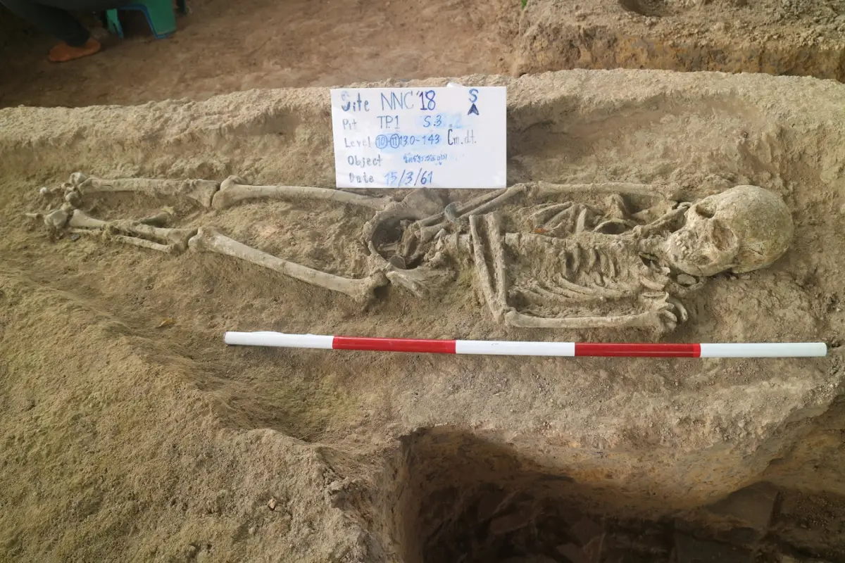
Ban Mak Archaeological Site
Open Days: Daily
Opening Hours: 08.00 – 17.00
Ban Mak Mai Archaeological Site in Yasothon Province is an ancient community in Kho Wang Subdistrict, Kho Wang District. It is located on a large earthen mound rising about 2 – 3 meters above the surrounding rice-field plain. The site has a surrounding moat, 3 ancient ponds, and Huai Phra Bang, a tributary of the Chi River, flowing along the southern side of the village. Archaeological evidence includes sema boundary stones and coarse sandy pottery fragments in orange and pale tones. The community was influenced by Dvaravati and Khmer cultures and is estimated to date back about 1,500 – 1,000 years. It is open daily from 08.00 to 17.00 with no admission fee, and is suitable for travelers interested in ancient settlements, moated communities, Dvaravati culture, Khmer influence, and local history in southern Yasothon.
Ban Mak Mai Archaeological Site in Yasothon Province is an important ancient community in Kho Wang District. It is located in Ban Mak Mai, Kho Wang Subdistrict, southern Yasothon. The site preserves traces of an ancient settlement that once formed part of the cultural landscape of the lower Chi River basin. Although Ban Mak Mai is not a large historical park with monumental standing ruins, its mound, moat, ancient ponds, pottery fragments, and sema stones provide valuable evidence of settlement, water management, religion, and cultural contact during the early historic period.
The most distinctive feature of Ban Mak Mai is its ancient settlement landscape. The community stands on a large earthen mound about 2 – 3 meters higher than the surrounding plain. The surrounding area is mainly rice fields, about 114 meters above mean sea level. This type of settlement pattern is significant in northeastern Thailand because ancient communities often selected slightly elevated ground near water sources. Such locations were suitable for long-term habitation, rice cultivation, seasonal water control, and the creation of a clear community boundary.
Ban Mak Mai is described as an ancient community surrounded by a moat. This moat was a key part of the ancient settlement system. It marked the boundary of the community, supported water use, and helped structure the relationship between houses, cultivated land, sacred areas, and nearby water sources. In addition to the moat, the site also has 3 ancient ponds. These water features show that the settlement was not random or temporary, but an organized community that managed water as part of daily life and long-term occupation.
On the southern side of the village flows Huai Phra Bang, a tributary of the Chi River. This stream likely functioned as the natural moat or boundary on the southern side of the ancient community. The use of a natural watercourse as part of the settlement boundary is a common feature in many ancient communities. It reflects the practical and symbolic importance of water in ancient settlement planning. At Ban Mak Mai, the relationship between the mound, moat, ponds, and stream is central to understanding the site.
The site was influenced by Dvaravati and Khmer cultures and is estimated to date back about 1,500 – 1,000 years. This period was a time when many communities in northeastern Thailand developed more complex social and religious structures. Some areas received Buddhist influence associated with Dvaravati culture, while later or overlapping phases show connections with Khmer cultural networks. Ban Mak Mai belongs to this wider pattern of cultural interaction in the lower Northeast.
The discovery of sema boundary stones is especially important. Sema stones were used to mark sacred Buddhist ritual boundaries, and their presence indicates a Buddhist religious layer at the site. In the context of northeastern Thailand, sema stones are strongly associated with Dvaravati-period Buddhist culture. Their presence at Ban Mak Mai shows that the ancient community was not merely an agricultural settlement, but also had sacred or ritual areas related to Buddhist practice.
Pottery fragments found at Ban Mak Mai are described as coarse sandy wares in orange and pale tones. These fragments are valuable because pottery is one of the clearest forms of evidence for everyday life. Ancient pottery was used for cooking, storing food, holding water, preparing meals, and sometimes for ritual purposes. When pottery breaks and remains in settlement layers, it becomes an important archaeological record of domestic life, craft technology, and long-term habitation.
The coarse sandy texture of the pottery reflects local production techniques. Sand or coarse temper was often mixed with clay to strengthen vessels and improve their durability during firing and use. The orange and pale tones of the pottery surface relate to clay sources, firing temperature, and firing conditions. Although pottery fragments may appear simple, they preserve information about the technology, resources, and daily activities of the ancient community.
Ban Mak Mai is part of a wider group of ancient communities in Kho Wang District. Nearby areas include Ban Nam Om Ancient Community, Don Phra That Ancient Monument in Ban Phi Phuan, and other settlement traces in southern Yasothon. The concentration of archaeological sites in this district shows that Kho Wang has deep historical roots. The area was not only an agricultural landscape in recent times, but a settlement zone with long cultural development and connections to broader regional networks.
Geographically, Ban Mak Mai is closely connected with Huai Phra Bang and the Chi River system. Huai Phra Bang provided a nearby water source, while the Chi River formed a larger regional corridor connecting communities across the lower Northeast. Ancient communities often developed near such water networks because they supported farming, movement, exchange, and contact with neighboring settlements. Ban Mak Mai’s location on a mound near water therefore reflects a practical and well-chosen settlement strategy.
The site’s value lies in reading the landscape as a whole. Visitors should not expect large restored buildings, but should focus on the ancient mound, the moat, the 3 ancient ponds, the southern stream, the rice-field setting, and the present village. These elements together reveal how ancient people shaped and used the land. The settlement was organized around water, raised ground, daily habitation, and sacred space. This makes Ban Mak Mai an important example of a community-based archaeological landscape.
The combined Dvaravati and Khmer influence at Ban Mak Mai also makes the site important for understanding cultural transition in northeastern Thailand. The sema stones point to Buddhist practice and Dvaravati influence, while the broader cultural setting connects the community with Khmer-period networks. This shows how smaller communities in the region received, adapted, and localized external cultural influences without losing their own settlement identity.
For travelers interested in archaeology, Ban Mak Mai is best explored slowly. Begin by observing the position of the village and mound. Then look for the relationship between the settlement area, moat, ancient ponds, and Huai Phra Bang. Understanding the site depends on seeing how water, land, and community were arranged together. This approach turns the visit into a study of an ancient landscape rather than a quick photo stop.
The simplicity of the site is part of its value. Many ancient communities in the Northeast survive not as large monuments, but as mounds, moats, ponds, old place names, temple areas, and local memory. These forms of evidence can tell a deep story about how people lived, farmed, worshipped, and organized their community. Ban Mak Mai should therefore be understood as a living cultural landscape where the ancient settlement remains embedded within the modern village.
Wat Ban Mak Mai, also locally associated with the name Wat Ma Mai, is an important religious and community point in the present landscape. In northeastern Thailand, temple areas often overlap with or stand near older sacred spaces. This continuity shows how sacred landscapes can be reused and reinterpreted over time. At Ban Mak Mai, the temple, village, mound, moat, and ancient water features should be viewed together as part of one cultural landscape.
Kho Wang District is located in the southern part of Yasothon Province and borders Maha Chana Chai District of Yasothon and Rasi Salai District of Si Sa Ket. The route to Ban Mak Mai follows the local road network between Kho Wang and Rasi Salai. This gives visitors a clear view of the rural landscape that shaped ancient settlement: rice fields, small villages, streams, and low-lying agricultural land.
Ban Mak Mai can be combined with other nearby places in Kho Wang District. Don Phra That Ancient Monument in Ban Phi Phuan is one of the important historical sites of the district. Huai Phra Bang Reservoir is another nearby water-related destination. Visiting these places together helps travelers understand Kho Wang as a landscape of ancient settlement, sacred places, water resources, and rural community life.
For a wider Yasothon itinerary, travelers can continue to Wat Phra Phutthabat Yasothon in Maha Chana Chai District or head toward Yasothon city to visit Phaya Thaen Public Park, the Toad Museum, Wat Mahathat, and the old Ban Sing Tha community. This route connects small-scale archaeological landscapes with major religious, cultural, and urban heritage sites of the province.
The best time to visit Ban Mak Mai is in the morning or late afternoon, when the weather is more comfortable for walking. During the rainy season or when the ponds and streams hold more water, the relationship between the settlement and its water system becomes easier to understand. During the rice-growing season, the surrounding fields also show how the ancient landscape continues to support agricultural life in the present.
Visitors should prepare drinking water, a hat, or an umbrella and wear comfortable shoes. Since the area includes village roads, temple space, fields, and local community areas, visitors should walk respectfully. Do not enter private land, rice fields, or gardens without permission. Do not collect pottery fragments, stones, or any old objects from the site. Do not dig, disturb soil layers, or leave rubbish in the area.
Ban Mak Mai Archaeological Site is suitable for students, cultural travelers, local-history researchers, and visitors who want to understand Yasothon beyond its main festivals and city attractions. The site shows how a small ancient community can reveal a large historical story when mound, moat, pottery, sema stones, stream, and village landscape are understood together.
In local historical terms, Ban Mak Mai confirms that Kho Wang District has a long cultural background. The presence of several ancient communities in this area reflects the importance of elevated land, water sources, and routes linking Yasothon and Si Sa Ket. Ban Mak Mai helps complete the picture of Yasothon as a province with deep archaeological roots, not only modern cultural attractions.
Getting There to Ban Mak Mai Archaeological Site is straightforward from the road between Kho Wang District in Yasothon Province and Rasi Salai District in Si Sa Ket Province. From that road, turn east toward Ban Mak Mai for about 1 kilometer. From Yasothon city, travel south toward Kho Wang District, then continue to Kho Wang Subdistrict and Ban Mak Mai. The route is suitable for private cars, rental cars, and local hired vehicles.
Visitors should allow at least 1 to 2 hours for the main archaeological landscape. If combining the visit with Don Phra That, Huai Phra Bang Reservoir, Wat Phra Phutthabat Yasothon, or Yasothon city attractions, a half-day or full-day plan is more suitable. This route allows travelers to experience ancient settlement, religious heritage, water landscapes, and local community life in one trip.
In summary, Ban Mak Mai Archaeological Site is a culturally valuable destination in Yasothon Province. It preserves an ancient moated settlement on an elevated mound, 3 ancient ponds, Huai Phra Bang on the southern side, sema stones, and pottery fragments. These elements show the development of a community influenced by Dvaravati and Khmer cultures about 1,500 – 1,000 years ago. For travelers who want to understand the deep history of Kho Wang and the lower Chi River basin, Ban Mak Mai is a meaningful place to visit and learn from the real landscape.
| Name | Ban Mak Mai Archaeological Site |
| Related Names | Ban Mak Mai, Wat Ban Mak Mai, Wat Ma Mai, Ban Mak Mai Ancient Community, Ban Mak Mai Cultural Heritage Site |
| Location | Ban Mak Mai, Kho Wang Subdistrict, Kho Wang District, Yasothon Province |
| Address | Kho Wang Subdistrict, Kho Wang District, Yasothon Province 35160, Thailand |
| Coordinates | 15.350385, 104.355673 |
| Highlights | Moated ancient community, large mound rising about 2 – 3 meters above surrounding rice fields, 3 ancient ponds, Huai Phra Bang on the southern side, sema stones, and coarse sandy pottery fragments in orange and pale tones |
| History | Influenced by Dvaravati and Khmer cultures, estimated to date back about 1,500 – 1,000 years |
| Key Evidence | Sema boundary stones, coarse sandy pottery fragments, orange and pale pottery, surrounding moat, ancient ponds, and Huai Phra Bang as the southern water boundary |
| Name Origin | Ban Mak Mai is the local village name and is associated with the present community and Wat Ban Mak Mai, also locally known as Wat Ma Mai. |
| Distinctive Features | Large elevated mound about 2 – 3 meters above the surrounding plain, surrounded by a moat, with 3 ancient ponds and a natural stream on the southern side |
| Main Areas / Zones | 1. Ban Mak Mai Ancient Mound 2. Surrounding Moat 3. Three Ancient Ponds 4. Sema Stone Area 5. Pottery Fragment Area 6. Huai Phra Bang On The Southern Side 7. Wat Ban Mak Mai Or Wat Ma Mai And Local Sacred Area 8. Kho Wang – Rasi Salai Connecting Route |
| Caretaker | Kho Wang Subdistrict Administrative Organization, Yasothon Local Natural And Cultural Environment Conservation Unit, Wat Ban Mak Mai, And Ban Mak Mai Community |
| Travel Information | Use the road between Kho Wang District, Yasothon Province, and Rasi Salai District, Si Sa Ket Province, then turn east toward Ban Mak Mai for about 1 km. From Yasothon city, travel south toward Kho Wang District and continue to Ban Mak Mai. |
| Current Status | Open to visitors as an ancient community, cultural heritage site, and archaeological learning area in Kho Wang District, Yasothon Province |
| Open Days | Daily |
| Opening Hours | 08.00 – 17.00 |
| Admission Fee | No Admission Fee |
| Facilities | Community access roads, parking areas near the village and temple, local resting areas, restaurants and cafés in Kho Wang and Rasi Salai, and accommodations in Kho Wang, Rasi Salai, and Yasothon city |
| Main Contact Number | Kho Wang Subdistrict Administrative Organization Tel. 045-979768 Yasothon Local Natural And Cultural Environment Conservation Unit Tel. 0-4571-1655-6 |
| Official Website / Official Page | Kho Wang Subdistrict Administrative Organization: khowang.go.th |
| Nearby Tourist Attractions | 1. Wat Ban Mak Mai / Wat Ma Mai, within the same area 2. Huai Phra Bang, about 1 km 3. Huai Phra Bang Reservoir, about 5 km 4. Don Phra That Ancient Monument, Ban Phi Phuan, about 8 km 5. Wat Phra Phutthabat Yasothon, about 30 km 6. Rasi Salai District, Si Sa Ket Province, about 25 km 7. Phaya Thaen Public Park And Toad Museum, about 65 km 8. Wat Mahathat Yasothon, about 65 km |
| Nearby Restaurants | 1. Lap Thai Amnat Restaurant, Kho Wang District, about 5 km, Tel. 088-040-1008 2. Made-To-Order Food Shop, Kho Wang District, about 6 km, Tel. 098-097-1672 3. 365 Americano Tea Bar, Kho Wang, about 6 km, Tel. 096-195-2297 4. Lelawa Cafe Rasi Salai Branch, about 25 km, Tel. 087-452-3233 5. ChaPayom Original Rasi Salai, about 25 km, Tel. 093-434-4755 |
| Nearby Accommodations | 1. Hom Krai Resort, Kho Wang District, about 8 km, Tel. 081-976-6776 2. Lanna Resort, Kho Wang District, about 10 km, Tel. 080-489-1169 3. Wang Sai Garden Resort, Kho Wang District, about 10 km, Tel. 089-718-5228 4. Rasi Resort, Rasi Salai District, about 25 km, Tel. 045-681-223 5. Sai Kaew Resort, Rasi Salai District, about 25 km, Tel. 045-620-780 6. The Green Hotel Rasi Salai, about 25 km, Tel. 064-062-9983 |
Frequently Asked Questions (FAQ)
Q: Where is Ban Mak Mai Archaeological Site located?
A: It is located at Ban Mak Mai, Kho Wang Subdistrict, Kho Wang District, Yasothon Province. The coordinates are 15.350385, 104.355673.
Q: What are the opening days and hours?
A: The site is open daily from 08.00 to 17.00.
Q: Is there an admission fee?
A: No. Visitors can view the ancient mound, moat, ancient ponds, temple area, and surrounding community landscape without an admission fee.
Q: Why is Ban Mak Mai historically important?
A: Ban Mak Mai is an ancient community influenced by Dvaravati and Khmer cultures, dating back about 1,500 – 1,000 years. Its moat, mound, sema stones, and pottery fragments show both habitation and religious activity.
Q: What archaeological evidence has been found at Ban Mak Mai?
A: Important evidence includes sema boundary stones, coarse sandy pottery fragments in orange and pale tones, the surrounding moat, 3 ancient ponds, and Huai Phra Bang on the southern side of the village.
Q: How is Ban Mak Mai related to Dvaravati and Khmer cultures?
A: The sema stones reflect Buddhist and Dvaravati influence, while the site’s broader historical context places Ban Mak Mai within the cultural network that later received Khmer influence in the early historic period.
Q: How can travelers get to Ban Mak Mai?
A: Use the road between Kho Wang District in Yasothon Province and Rasi Salai District in Si Sa Ket Province, then turn east toward Ban Mak Mai for about 1 km. From Yasothon city, travel south toward Kho Wang District and continue to the village.
Q: What nearby attractions can be combined with this visit?
A: Nearby places include Wat Ban Mak Mai, Huai Phra Bang, Huai Phra Bang Reservoir, Don Phra That Ancient Monument, Wat Phra Phutthabat Yasothon, Phaya Thaen Public Park, and Wat Mahathat Yasothon.
 Category: ●Art, Culture and Heritage
 Group: ●Historical Sites and Monuments
Last Update : 2 MonthAgo
 Last Update : 2 MonthAgo
 Click to Access the Navigation Map GPS
Ban Mak Archaeological Site Map
 Historical Sites and Monuments(6)
 Landmarks and Memorials(1)
 Art, Craft Centres, Tradition(4)
 Museums(1)
 Historic Homes and Cities(1)
 Places of Worship
 Temple(22)
 Church(1)
 Other Sacred Sites(9)
 Research and Development
 Royal Project(2)
 Suburban Living
 Village, Community(3)
 Local Market(1)
 Nature and Wildlife
 National Parks and Marine Reserves(2)
 Mountain (Doi)(2)
 Dam, Reservoir, Lake(7)
 River, Canal(2)
 Bays and Beaches(1)
 Other natural attractions(2)
 Entertainment and Agricultural
 Farms, Parks and Ecotourism(1)


