
lovethailand home >Northeastern Travel Attractions >Ubon Ratchathani Travel Attractions >Don Mot Daeng >Don Mot Daeng > Ko Don Mot Daeng
TL;DR: Ko Don Mot Daeng is located at Don Mot Daeng Subdistrict, Don Mot Daeng District, Ubon Ratchathani Province, open Daily, hours 08.00 – 17.00.
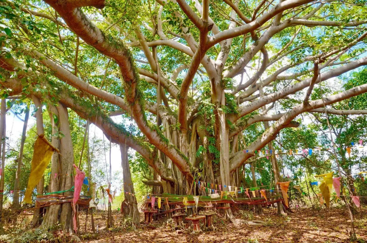
Ko Don Mot Daeng
Open Days: Daily
Opening Hours: 08.00 – 17.00
Ko Don Mot Daeng in Ubon Ratchathani is an island in the Mun River within Don Mot Daeng Subdistrict, Don Mot Daeng District. It is important both as a natural riverside landscape and as a historical place linked with the early foundation of Ubon Ratchathani. Local history connects the island with the group of people who migrated with Phra Wo and Phra Ta more than 200 years ago before moving onward to Dong U Phueng, the area that later became part of the city of Ubon Ratchathani. The island is suitable for travelers interested in the Mun River, rural Isan communities, local history, traditional settlement patterns, and nearby cultural routes such as Chedi Song Somdet at Wat Ban Khaen, Hat Sri Phirom, Wat Pak Nam Bueng Saraphang, and Ubon Ratchathani city.
Ko Don Mot Daeng in Ubon Ratchathani is a natural and historical destination with deep significance for understanding the roots of Ubon Ratchathani Province. The island lies in the Mun River in Don Mot Daeng Subdistrict, Don Mot Daeng District. Local memory regards this area as one of the early settlement points of people who migrated with Phra Wo and Phra Ta more than 200 years ago. From Don Mot Daeng, the community later expanded toward Dong U Phueng, which became an important foundation for the later development of Ubon Ratchathani. For this reason, Ko Don Mot Daeng is not only a river island. It is a landscape of memory, migration, settlement, and local identity.
The meaning of the name Don Mot Daeng is closely tied to geography. In local Isan usage, “don” refers to raised ground, a dry mound, or an island-like piece of land that rises above water. “Mot Daeng” became the specific name associated with this area and its community. Together, Don Mot Daeng suggests a raised landform or island in a river landscape. Over time, the name came to identify the community, the subdistrict, the district, and the historical identity of the area.
Ko Don Mot Daeng feels very different from central Ubon Ratchathani. It is not a large commercial attraction and not a resort-style riverside destination. It is a rural Mun River landscape with agricultural land, village roads, local temples, forest patches, and community belief areas. Visitors come here not for dramatic entertainment, but to understand a place where nature, settlement, and history meet. The quietness of the area is part of its strength.
The Mun River is central to the character of Ko Don Mot Daeng. It is one of the most important rivers in southern northeastern Thailand and has long supported transportation, agriculture, fishing, settlement, and local food culture. An island in this river would have been valuable in the past as a place of refuge, observation, and settlement. Standing near the island today helps travelers imagine how earlier communities selected land, used waterways, and adapted to the river environment.
The history of Ko Don Mot Daeng is connected with Phra Wo and Phra Ta, two important figures in the historical memory of Ubon Ratchathani. Their followers moved from the Lao side into the western side of the Mekong and later into the Mun River region. Don Mot Daeng became one of the places where the migrating group settled before moving further to Dong U Phueng. This movement is central to the story of how Ubon Ratchathani emerged as a community and later developed into an important city.
Seen as historical geography, Ko Don Mot Daeng stands between an older world of migration from the Mekong cultural zone and the later formation of Ubon Ratchathani on the Mun River. The choice of an island or raised land in a river environment shows practical knowledge of landscape. It provided access to water, protection, food sources, and travel routes. This makes the island an important place for understanding how communities formed before official urban centers became established.
Dong U Phueng is important in this story because it represents the next stage after Don Mot Daeng. After using Don Mot Daeng as a settlement base, the community expanded toward Dong U Phueng, where the foundations of Ubon Ratchathani were strengthened. The connection between Don Mot Daeng and Dong U Phueng shows how a river island settlement gradually evolved into a broader town-based society. Travelers interested in history should therefore view Ko Don Mot Daeng as the beginning of a larger narrative.
The surrounding landscape also explains the present identity of Don Mot Daeng District. The area includes lowland plains, sandy-loam soils, streams, ponds, fields, and rural settlements. Local life remains connected with rice farming, community temples, forest patches, and traditional belief areas such as sacred groves and local spirit places. These features give the district a strong rural Isan character and help visitors understand the everyday environment behind the historical story.
The main value of Ko Don Mot Daeng is the combination of river scenery and historical meaning. Visitors can see the Mun River as a living waterway, learn about the migration associated with Phra Wo and Phra Ta, and continue to Ban Khaen, where Chedi Song Somdet is located at Wat Ban Khaen. The chedi contains the relics of two important senior monks of Ubon Ratchathani and northeastern Thailand: Somdet Phra Maha Wirawong Tisso “Uan” and Somdet Phra Maha Wirawong Dhammadharo “Phim.” This nearby site adds an important Buddhist and cultural dimension to the route.
A visit to Ko Don Mot Daeng can therefore become a local history and culture route. Travelers can begin at the island to understand the early settlement narrative, continue to Ban Khaen and Chedi Song Somdet, and then move toward Ubon Ratchathani city to see the later urban center. This route creates a clear sequence from riverside settlement to religious heritage and finally to the modern provincial city.
Although Ko Don Mot Daeng has historical importance, its appeal does not come from a large museum-style presentation. The value lies in the real landscape. Visitors can stand near the Mun River and imagine the lives of people who arrived here more than 200 years ago. The island gives physical shape to a historical story that might otherwise feel abstract. It shows that history is not only found in buildings, monuments, or documents. It is also found in rivers, fields, islands, villages, and local names.
Suitable activities at Ko Don Mot Daeng include viewing the Mun River, photographing rural riverside scenery, learning about Phra Wo and Phra Ta, exploring Don Mot Daeng community routes, visiting nearby temples, and continuing to other Mun River attractions. Hat Sri Phirom, also known as Hat Bueng Saraphang, is one of the nearby riverside attractions that can be included in a same-day route. It offers a different kind of Mun River experience with food rafts and leisure by the water.
For nature-oriented travelers, Ko Don Mot Daeng offers a community-scale view of the Mun River ecosystem. The surrounding district includes dry dipterocarp forest patches, mixed forest, agricultural land, water sources, and rural settlement areas. This is not a dense mountain forest, but it is important for local livelihoods, community memory, and the everyday landscape of Isan. Visitors who pay attention to these details will understand how local people live with land, water, and seasonal change.
Photography at Ko Don Mot Daeng is best approached as documentary travel photography. Good subjects include the Mun River, rural roads, agricultural land, temples, community life, Chedi Song Somdet, and the broader Don Mot Daeng landscape. Morning and late afternoon provide softer light and a calmer atmosphere. This is not a destination built for dramatic photo props, but it offers meaningful images of real local heritage.
For families, Ko Don Mot Daeng is suitable as a place to introduce children and young travelers to local history. The story of Phra Wo, Phra Ta, the Mun River, Dong U Phueng, and Ubon Ratchathani can be explained clearly through the actual landscape. Instead of reading about history only as dates and names, visitors can see the kind of place where people once settled and understand why water and raised land mattered.
For foreign travelers, Ko Don Mot Daeng helps explain northeastern Thailand beyond common images of temples, festivals, and the Mekong River. The place reveals migration history, Lao-Isan cultural links, river settlement, rural landscapes, and the formation of a provincial city. It is suitable for visitors who want a deeper understanding of Ubon Ratchathani and are interested in how communities developed along the Mun River.
Getting There from Ubon Ratchathani city is straightforward by private car or hired vehicle. Don Mot Daeng District is about 30 km from the city. Travelers can take the main route toward Don Mot Daeng and then continue on local roads into Don Mot Daeng Subdistrict and the riverside community area. Because the site is local and community-based, using navigation together with local signs and local guidance is practical.
Travelers arriving from Ubon Ratchathani Airport can first enter Ubon Ratchathani city and then continue toward Don Mot Daeng District. A private car, rental car, or chartered van is the most convenient option because it allows visitors to combine Ko Don Mot Daeng with Ban Khaen, Chedi Song Somdet, Hat Sri Phirom, Wat Pak Nam Bueng Saraphang, and city attractions in one route.
A half-day route can focus on Ko Don Mot Daeng, Ban Khaen, and Chedi Song Somdet. Start at Ko Don Mot Daeng for the Mun River and settlement history, then continue to Wat Ban Khaen to see the important chedi. After that, visitors can return to Don Mot Daeng town or Ubon Ratchathani city for food. A full-day route can add Hat Sri Phirom, Wat Pak Nam Bueng Saraphang, Thung Si Mueang, and Ubon Ratchathani National Museum.
Travelers who want to connect Ko Don Mot Daeng with the wider history of Ubon Ratchathani should continue into the city after visiting the island. Wat Thung Si Mueang, Wat Luang, Thung Si Mueang, and the Ubon Ratchathani National Museum help complete the historical picture. The journey then moves from a river island settlement to the later urban and religious center of the province.
Facilities at Ko Don Mot Daeng are community-based rather than commercial. Visitors should prepare drinking water, sun protection, comfortable walking shoes, and a camera. Food and café options are available in Don Mot Daeng District and Ubon Ratchathani city, where services are more developed. Planning ahead makes the visit smoother and keeps expectations aligned with the local character of the site.
Ko Don Mot Daeng is not primarily a swimming attraction. Visitors should treat it mainly as a historical and riverside landscape. Anyone approaching the Mun River should be careful of water level, current, riverbank edges, and slippery or unstable ground. Children should be supervised at all times, and visitors should not enter unknown water.
The best visiting time is during the daytime, within the opening hours of 08.00 to 17.00. Morning is good for photography and cooler weather. Late afternoon is good for riverside light before returning to Ubon Ratchathani city. The cool season and early hot season are comfortable for walking, while the rainy season may bring greener scenery but requires more care on local roads and near the river.
There is no general ticket-style admission fee for the main local area. Main expenses come from optional services such as food, drinks, hired transport, local services, or special community activities when available. Groups should prepare transport and meal expenses in advance.
Respect for the local community is important. Ko Don Mot Daeng and its surrounding areas are living communities, not a separated tourist stage. Visitors should park properly, avoid disturbing houses or farming areas, ask permission before photographing people, keep the riverside clean, and respect temples, sacred groves, and local belief areas.
The strength of Ko Don Mot Daeng is its authenticity and historical depth. It does not depend on artificial attractions. Its meaning comes from the fact that it is a real place connected with the early foundation story of Ubon Ratchathani. Travelers who give time to the story will see the island as a river landscape, a former settlement, a memory of Phra Wo and Phra Ta, and one of the origins of the city’s historical identity.
In conclusion, Ko Don Mot Daeng is ideal for travelers who want to understand Ubon Ratchathani beyond major temples and city landmarks. It connects the Mun River, local settlement, Phra Wo and Phra Ta, rural community life, traditional belief spaces, and nearby religious heritage. A well-planned visit turns Ko Don Mot Daeng into the beginning of a meaningful Ubon Ratchathani story, leading from the river island to Ban Khaen, Dong U Phueng, and the modern provincial city.
| Name | Ko Don Mot Daeng |
| Location | Don Mot Daeng Subdistrict, Don Mot Daeng District, Ubon Ratchathani Province |
| Address | Mun River island area, Don Mot Daeng Subdistrict, Don Mot Daeng District, Ubon Ratchathani 34000 |
| Coordinates | 15.290439, 105.052390 |
| Highlights | Island in the Mun River, historical site connected with Phra Wo and Phra Ta, early settlement before the move to Dong U Phueng, rural riverside community landscape, and route connections to Chedi Song Somdet, Wat Ban Khaen, and Ubon Ratchathani city |
| History | A settlement area of people who migrated with Phra Wo and Phra Ta more than 200 years ago before expanding to Dong U Phueng, an important foundation area of Ubon Ratchathani. |
| Name Origin | “Don” refers to raised land or an island-like area above water. “Mot Daeng” is the local place name associated with the community. Together, the name refers to the raised island area in the Mun River that later became the identity of the subdistrict and district. |
| Distinctive Features | A large island in the Mun River with rural river scenery, agricultural surroundings, forest patches, local belief spaces, and historical links with the early settlement of Ubon Ratchathani. |
| Travel Information | From Ubon Ratchathani city, travel toward Don Mot Daeng District, about 30 km away, then continue into Don Mot Daeng Subdistrict and local riverside roads. Private car, rental car, or chartered van is recommended. |
| Current Status | Open as a local attraction, historical learning site, and Mun River community landscape of Don Mot Daeng Subdistrict. |
| Open Days | Daily |
| Opening Hours | 08.00 – 17.00 |
| Fees | No general admission ticket for the local area. Food, drinks, hired transport, or local services are charged by individual providers. |
| Facilities | Community access routes, Mun River viewpoints, nearby temples and religious sites, small community shops or local food services during service periods, and basic services in Don Mot Daeng District or Ubon Ratchathani city |
| Main Areas / Zones | 1. Mun River island zone 2. Mun River scenery zone 3. Don Mot Daeng community and riverside agricultural zone 4. Phra Wo and Phra Ta historical memory zone 5. Local belief and sacred grove zone in nearby communities 6. Ban Khaen and Chedi Song Somdet route zone 7. Route connection zone to Hat Sri Phirom and Ubon Ratchathani city |
| Caretaker | Don Mot Daeng Subdistrict Administrative Organization, Don Mot Daeng community, and local agencies in Don Mot Daeng District |
| Main Contact Number | Don Mot Daeng Subdistrict Administrative Organization Tel. 045-429259 |
| Official Website / Local Information Sources | Don Mot Daeng Subdistrict Administrative Organization website Cultural Environment Conservation Database LoveThailand.org tourism information |
| Nearby Tourist Attractions | 1. Chedi Song Somdet, Wat Ban Khaen, about 5 km 2. Ban Khaen Community And Don Pu Ta Area, about 5 km 3. Hat Sri Phirom Or Hat Bueng Saraphang, about 18 km 4. Wat Pak Nam Bueng Saraphang, about 18 km 5. Thung Si Mueang Ubon Ratchathani, about 30 km 6. Ubon Ratchathani National Museum, about 30 km, Tel. 045-251015 7. Wat Thung Si Mueang, about 31 km 8. Wat Phra That Nong Bua, about 35 km |
| Nearby Restaurants | 1. Don Mot Daeng Community Restaurants, about 3 km 2. Yoshio Cafe Don Mot Daeng, about 8 km 3. The Bana Dragon Cafe Don Mot Daeng, about 10 km 4. Hat Sri Phirom Community Restaurants And Food Rafts, about 18 km 5. The Outside Inn Ubon Ratchathani, about 28 km, Tel. 088-581-2069 6. Peppers Restaurant & Bakery Ubon Ratchathani, about 30 km, Tel. 045-245275 7. Ubon Seafood, about 32 km |
| Nearby Accommodations | 1. Lung Kheng Farm And Homestay, Tha Mueang Subdistrict, Don Mot Daeng District, about 18 km, Tel. 063-380-8008, 083-071-3656 2. Wangnong Resort Ubon Ratchathani, about 25 km, Tel. 094-291-5419 3. The Outside Inn Ubon Ratchathani, about 28 km, Tel. 088-581-2069 4. T3 House Ubon Ratchathani, about 30 km, Tel. 045-244911, 045-244912 5. Laithong Hotel Ubon Ratchathani, about 31 km, Tel. 098-118-0194 6. Accommodations In Ubon Ratchathani City, about 30 km |
Frequently Asked Questions (FAQ)
Q: Where is Ko Don Mot Daeng located?
A: Ko Don Mot Daeng is located in the Mun River within Don Mot Daeng Subdistrict, Don Mot Daeng District, Ubon Ratchathani Province. It is a local community and historical landscape of Don Mot Daeng District.
Q: Why is Ko Don Mot Daeng historically important?
A: Ko Don Mot Daeng is linked with the settlement of people who migrated with Phra Wo and Phra Ta more than 200 years ago before moving onward to Dong U Phueng, an important foundation area of Ubon Ratchathani.
Q: What are the opening days and hours of Ko Don Mot Daeng?
A: Ko Don Mot Daeng opens daily from 08.00 to 17.00. Daytime visits are most suitable, especially in the morning or late afternoon.
Q: Is there an admission fee for Ko Don Mot Daeng?
A: There is no general admission ticket for the local area. Visitors pay only for optional services such as food, drinks, hired transport, or local services when available.
Q: What can visitors do at Ko Don Mot Daeng?
A: Visitors can view the Mun River landscape, photograph rural riverside scenery, learn about Phra Wo and Phra Ta, explore Don Mot Daeng community routes, and continue to Chedi Song Somdet, Wat Ban Khaen, or Hat Sri Phirom.
Q: How do travelers get to Ko Don Mot Daeng from Ubon Ratchathani city?
A: From Ubon Ratchathani city, travel toward Don Mot Daeng District, about 30 km away, then continue into Don Mot Daeng Subdistrict and local roads leading to the riverside island area.
Q: What nearby places can be visited with Ko Don Mot Daeng?
A: Nearby places include Chedi Song Somdet, Wat Ban Khaen, Ban Khaen community, Hat Sri Phirom, Wat Pak Nam Bueng Saraphang, Thung Si Mueang, Ubon Ratchathani National Museum, and Wat Thung Si Mueang.
Q: Is Ko Don Mot Daeng suitable for foreign travelers?
A: Yes. It is suitable for foreign travelers who want to understand the early settlement history of Ubon Ratchathani, the Mun River landscape, rural Isan communities, and the story of Phra Wo and Phra Ta in a real local setting.
 Category: ●Nature and Wildlife
 Group: ●Islands
Last Update : 1 MonthAgo
 Last Update : 1 MonthAgo
 Click to Access the Navigation Map GPS
 Art, Culture and Heritage
 Historical Sites and Monuments(5)
 Landmarks and Memorials(2)
 Royal Palace(1)
 Art, Craft Centres, Tradition(7)
 Museums(3)
 Places of Worship
 Temple(37)
 Other Sacred Sites(4)
 Research and Development
 Royal Project(2)
 Suburban Living
 Village, Community(2)
 Local Market(4)
 National Parks and Marine Reserves(5)
 Mountain (Doi)(6)
 Dam, Reservoir, Lake(8)
 Waterfalls(12)
 Hot Springs(1)
 Caves(2)
 River, Canal(11)
 Bays and Beaches(8)
Islands(2)
Bays and Beaches(8)
Islands(2)
 Other natural attractions(6)
 Entertainment and Agricultural
 Zoos and Aquariums(1)
 Animal camps and shows(1)
 Farms, Parks and Ecotourism(1)


