
lovethailand home >Northeastern Travel Attractions >Roi Et Travel Attractions >Nong Phok >Phu Khao Thong > Wang Nong Reservoir
TL;DR: Wang Nong Reservoir is located at Phu Khao Thong Subdistrict, Nong Phok District, Roi Et Province, Near The Border Landscape Between Nong Phok District In Roi Et And, open Daily, hours 08.00 – 17.00.
Wang Nong Reservoir
Open Days: Daily
Opening Hours: 08.00 – 17.00
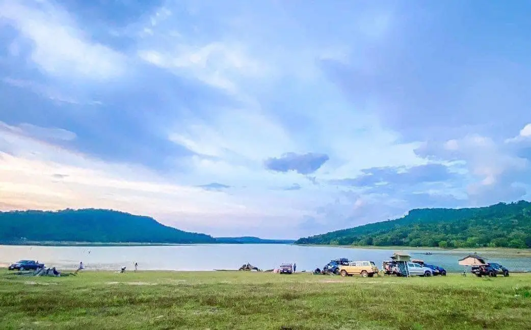
Wang Nong Reservoir in Roi Et Province, locally known as Khuean Wang Nong and officially monitored as Huai Wang Nong Reservoir, is a large mountain reservoir in Phu Khao Thong Subdistrict, Nong Phok District. It lies in the border landscape between Nong Phok District in Roi Et Province and Kuchinarai District in Kalasin Province, with natural connections toward the mountain area adjoining Mukdahan in some parts. The reservoir serves as a dry-season water-storage source, an irrigation reservoir, a local recreation area, a training venue for different organizations, and a peaceful nature destination surrounded by hills and rural scenery.
The strongest appeal of Wang Nong Reservoir is its wide water surface set within a mountain landscape. Visitors can see open water, distant hills, local roads, natural banks, and a quiet rural atmosphere. Many local visitors describe the place as an Isan-style inland sea because the view feels spacious and open, especially when the reservoir is full. During lower water periods, sandy banks, rock formations, and shoreline textures become more visible, creating a different but equally attractive landscape.
The reservoir is important for local water security. It stores water for use during the dry season, supporting communities in Nong Phok District and the adjoining area of Kuchinarai District. In this part of northeastern Thailand, seasonal rainfall can strongly affect agriculture. A reservoir such as Wang Nong helps local people manage water more effectively for farming, household use, ecological balance, and rural livelihoods. It is therefore both a scenic destination and a working water-management landscape.
In irrigation terms, Huai Wang Nong Reservoir is connected with the Roi Et Irrigation Project under Regional Irrigation Office 6. Its normal storage capacity is about 11.49 million cubic meters, while the maximum water-storage capacity is about 17.09 million cubic meters. The catchment area is about 37.20 square kilometers. These figures show that the reservoir is not a small local pond. It is a meaningful water structure for the Nong Phok mountain area and the communities depending on it.
The name Wang Nong reflects the original water landscape of the area. In Thai and Isan usage, huai refers to a stream or natural watercourse, while wang can refer to a deeper pool or water basin. The name preserves the memory of the older landscape before the site became a modern reservoir. Today, both names—Wang Nong Reservoir and Huai Wang Nong Reservoir—remain connected with local identity, water management, and community use.
Phu Khao Thong Subdistrict is known for mountain scenery and natural attractions, which gives the reservoir a stronger visual character than many lowland reservoirs. The surrounding hills frame the water beautifully, and the reservoir can be used as a base or stop on a broader Nong Phok nature route. Nearby places include Huai Phung Yai Reservoir, Tham Soda Waterfall, Wat Tham Soda, Pha Nam Yoi, Phra Maha Chedi Chai Mongkhon, Pha Mok Mi Wai, and Tham Pha Nam Thip Non-Hunting Area.
The area also has conservation value. The reservoir is associated with a wildlife-conservation area and forest-related surroundings. Water, shoreline plants, birds, fish, insects, and small wildlife all form part of the local freshwater and hill ecosystem. Visitors should understand that this is not only a place for photographs and relaxation. It is also part of a natural system that supports both people and wildlife.
Wang Nong Reservoir is best suited to simple, low-impact travel. Visitors can enjoy the water view, sit quietly by the reservoir, take landscape photographs, rest with family, picnic in suitable areas, observe nature, or use the place as a peaceful stop between other Nong Phok attractions. The destination is not designed as a large commercial tourist complex. Its charm comes from open water, hills, wind, and local quietness.
The scenery changes with the water level and season. When the water is high, the reservoir appears broad and lake-like, reflecting the sky and surrounding hills. When the water level drops, sandy banks and rocks become more visible, creating interesting photography spots. This seasonal character makes each visit slightly different. Travelers who enjoy natural landscapes will appreciate how the reservoir changes between the rainy season, cool season, and dry season.
The best times to visit are morning and late afternoon. Morning offers fresh air, soft light, and a calm atmosphere. Late afternoon is ideal for water reflections, hill views, and photography. Midday can be hot because some areas around the reservoir are open. Visitors should bring drinking water, sun protection, and appropriate footwear, especially when walking near rocky or sandy areas.
Wang Nong Reservoir is open daily from 08.00 to 17.00. These hours are suitable for safe general visits because the roads, reservoir edges, and local access routes are easier to see in daylight. Since the reservoir lies in a rural mountain area, visitors unfamiliar with the route should avoid entering or leaving late at night. Daytime travel is safer and more comfortable for families, elderly travelers, and first-time visitors.
Getting There is easiest by private car, motorcycle, or local hired vehicle. From Nong Phok District, travel toward Phu Khao Thong Subdistrict, located northeast of Nong Phok town. Continue on local roads toward Ban Phu Khao Thong and Huai Wang Nong Reservoir. From Roi Et city, the trip is suitable for a full-day route or an overnight stay in Nong Phok, because Phu Khao Thong is relatively far from the city center.
For navigation, visitors can use the coordinates 16.32200594, 104.2357739. Local roads near the reservoir pass through rural and natural areas. Drivers should use moderate speed, check vehicle condition, and avoid traveling during heavy rain or after dark. Since shops and services are not as dense as in Nong Phok town, it is practical to prepare drinking water, snacks, and basic supplies before reaching the reservoir.
The reservoir can be included in a broader Nong Phok travel route. A strong itinerary can combine Wang Nong Reservoir with Phra Maha Chedi Chai Mongkhon, Wat Pha Nam Thip Thep Prasit Wanaram, Pha Mok Mi Wai, Pha Phu Thai, Tham Pha Nam Thip Non-Hunting Area, Huai Phung Yai Reservoir, and Tham Soda Waterfall. This route shows Roi Et’s mountain side, which is different from the province’s city temples, markets, and lowland attractions.
Recommended activities include water viewing, landscape photography, quiet rest, picnicking in suitable areas, observing freshwater ecosystems, fishing where permitted, and camping only in areas allowed by local caretakers. Any overnight stay, camping, kayaking, or group activity should respect the rules of the reservoir, the forest area, and the local community. Cleanliness and quiet behavior are essential in this kind of natural site.
For families, Wang Nong Reservoir is a useful outdoor learning place. Children can see how a reservoir stores water for the dry season, supports farming, provides fish habitats, and connects several provinces through a mountain water system. This makes the site educational as well as relaxing. Parents should supervise children closely near the water, rocky banks, and any irrigation structures.
For photographers, the reservoir offers several strong subjects: open water, hills surrounding the reservoir, sandy banks, exposed rocks during low-water periods, rural access roads, and evening reflections. The best photographs often come from simple wide-angle views that show the relationship between water and mountains. Visitors should avoid entering unsafe shoreline areas or restricted irrigation zones for a better photo angle.
For international travelers, Wang Nong Reservoir can be understood as a mountain irrigation reservoir in northeastern Thailand. It is not a large hydroelectric dam or a resort lake. It is a practical community reservoir that stores water, supports agriculture, connects with conservation areas, and offers a peaceful local nature experience. The place helps foreign visitors understand how water, hills, forest, and rural life come together in Roi Et Province.
Environmental care is important. Visitors should not litter, throw food waste into the water, release non-native aquatic animals, cut branches, disturb wildlife, or make loud noise. A clean reservoir protects water quality, fish, birds, shoreline plants, and the local tourism image of Phu Khao Thong Subdistrict. Responsible use allows the area to remain useful for both communities and visitors.
Safety is also important. Visitors should not swim in unsafe areas, walk too close to steep banks, leave children alone near the water, or enter irrigation and drainage structures without permission. Reservoirs are working water-management areas, so they should be respected differently from ordinary parks. Travelers should also plan the return journey before dark.
Food options near the reservoir include local shops and simple community food in Phu Khao Thong Subdistrict, while more choices are available in Nong Phok town. Visitors who want restaurants and cafes should eat before or after entering the reservoir area. Nong Phok town has cafes, local restaurants, grilled food, seafood-style restaurants, and simple made-to-order food shops suitable for a nature-route stop.
Accommodation is available in Nong Phok District and along the broader route toward Pha Nam Yoi and Phra Maha Chedi Chai Mongkhon. Visitors who want to stay close to nature may choose local accommodation or permitted camping areas near the reservoir. Travelers who prefer more services should stay in Nong Phok town. For a comfortable and safe trip, an overnight stay in Nong Phok is often more practical than rushing back to Roi Et city after an afternoon visit.
In summary, Wang Nong Reservoir in Roi Et Province is a valuable mountain reservoir in Phu Khao Thong Subdistrict, Nong Phok District. It is known locally as Khuean Wang Nong and officially monitored as Huai Wang Nong Reservoir. The site stores water for dry-season use, supports agriculture, connects with conservation landscapes, and provides a quiet scenic place for visitors. Open daily from 08.00 to 17.00, it is ideal for travelers who want to see Roi Et through water, mountains, rural life, and peaceful nature.
| Name | Wang Nong Reservoir |
| Related Names / Official Name | Khuean Wang Nong / Huai Wang Nong Reservoir / Phu Khao Thong Reservoir / Irrigation Reservoir In Nong Phok District |
| Type | Irrigation Reservoir, Lakeside Recreation Area, Nature Learning Site, And Reservoir Connected With Wildlife-Conservation Surroundings |
| Location | Phu Khao Thong Subdistrict, Nong Phok District, Roi Et Province, Near The Border Landscape Between Nong Phok District In Roi Et And Kuchinarai District In Kalasin |
| Address | Ban Phu Khao Thong, Phu Khao Thong Subdistrict, Nong Phok District, Roi Et Province 45210, Thailand |
| Coordinates | 16.32200594, 104.2357739 |
| Highlights | Wide Water Surface Surrounded By Hills, Peaceful Local Atmosphere, Sandy Banks In Some Seasons, Exposed Rocks During Low-Water Periods, And Connection To Nong Phok Nature Routes |
| Importance | Stores Water For Dry-Season Use In Nong Phok And Adjoining Kuchinarai Areas, Supporting Agriculture, Community Water Use, Recreation, And Freshwater Ecology |
| Related Irrigation Organization | Roi Et Irrigation Project, Regional Irrigation Office 6, Royal Irrigation Department |
| Normal Storage Capacity | About 11.49 Million Cubic Meters |
| Maximum Storage Capacity | About 17.09 Million Cubic Meters |
| Catchment Area | About 37.20 Square Kilometers |
| Reservoir Structure Size | About 900 Meters Wide And 18.20 Meters High According To Royal Irrigation Department SWOC Data |
| Recommended Activities | Water Viewing, Nature Photography, Quiet Rest, Picnicking In Suitable Areas, Freshwater Ecosystem Learning, Fishing Where Permitted, Camping Only In Approved Areas, And Connecting With Nong Phok Nature Attractions |
| Travel Information | From Nong Phok District, travel northeast toward Phu Khao Thong Subdistrict, then follow local roads to Ban Phu Khao Thong and Huai Wang Nong Reservoir. Best reached by private car, motorcycle, or local hired vehicle. |
| Distance From Nong Phok Town | About 24 km to Phu Khao Thong Subdistrict, then continue on local roads to the reservoir area |
| Current Status | Open For Visits And Still Listed In The Royal Irrigation Department Reservoir-Monitoring System |
| Open Days | Daily |
| Opening Hours | 08.00 – 17.00 |
| Fees | No Admission Fee For The General Reservoir Area |
| Facilities | Access Roads, Reservoir Viewpoints, Rest Areas, Shoreline Open Spaces, Parking Where Available, Natural Surroundings, And Basic Services In Phu Khao Thong Subdistrict And Nong Phok Town |
| Main Areas / Zones | 1. Huai Wang Nong Reservoir Water Area 2. Dam Crest And Viewpoint Zone 3. Seasonal Sandy Bank And Shoreline Area 4. Rocky Shore And Northern Hill View Zone 5. Wildlife-Conservation And Natural Surrounding Zone 6. Picnic And Rest Area 7. Ban Phu Khao Thong Access Route Zone 8. Nong Phok – Pha Nam Yoi – Pha Mok Mi Wai Nature Route Connection Zone |
| Responsible / Related Organizations | Royal Irrigation Department, Roi Et Irrigation Project, Regional Irrigation Office 6, Phu Khao Thong Subdistrict Municipality, Forest-Related Conservation Units, And Ban Phu Khao Thong Community |
| Local Contact Number | Phu Khao Thong Subdistrict Municipality, Tel. 043-030-482 |
| Best Visiting Time | Morning For Fresh Air And Soft Light; Late Afternoon For Mountain Views, Water Reflections, And Nature Photography |
| Visitor Etiquette | Do Not Litter, Do Not Swim In Unsafe Areas, Do Not Enter Irrigation Or Drainage Structures Without Permission, Do Not Disturb Wildlife, Do Not Cut Branches, Keep Children Away From Water Edges, And Respect Local Communities And Nature |
| Nearby Tourist Attractions | 1. Ban Phu Khao Thong And Phu Khao Thong Community Area, About 2 km 2. Huai Phung Yai Reservoir, About 12 km 3. Tham Soda Waterfall And Wat Tham Soda, About 14 km 4. Phra Maha Chedi Chai Mongkhon, About 16 km 5. Wat Pha Nam Thip Thep Prasit Wanaram, About 16 km 6. Pha Mok Mi Wai, About 20 km 7. Pha Phu Thai, About 22 km 8. Tham Pha Nam Thip Non-Hunting Area, About 22 km 9. Nong Phok Market And Nong Phok Town Area, About 24 km |
| Nearby Restaurants | 1. Local Food Shops In Phu Khao Thong Subdistrict, About 2 – 8 km 2. Local Restaurants Around Ban Phu Khao Thong And The Reservoir Access Route, About 3 – 8 km 3. 29 Café Nong Phok, About 24 km, Tel. 088-324-3517 4. Big Seafood Nong Phok, About 24 km, Tel. 061-040-6854 5. Wali Land Garden Cafe, About 25 km, Tel. 087-221-1909 6. Today Coffee Nong Phok, About 25 km, Tel. 087-221-1909 7. Pai Nom Sod 168 Milk At Home, About 26 km, Tel. 094-991-2212 |
| Nearby Accommodations | 1. Ban Suan Phu Khao Thong And Local Accommodation Near The Reservoir, About 2 – 5 km 2. Permitted Reservoir-Side Camping Areas, About 0 – 2 km 3. Meethip Hotel, Nong Phok District, About 24 km, Tel. 089-942-0701, 087-949-9119 4. Resort Baan Fahsai Dao Suay, About 28 km, Tel. 089-009-6439 5. Hanchana’s Sweet Home, About 28 km, Tel. 087-224-2867 6. Phu Dao Homestay, About 30 km, Tel. 065-293-5353 7. Por Palm Si Rung, About 30 km, Tel. 091-054-9815 |
Frequently Asked Questions (FAQ)
Q: Where is Wang Nong Reservoir located?
A: Wang Nong Reservoir is located in Phu Khao Thong Subdistrict, Nong Phok District, Roi Et Province, near the border landscape between Nong Phok District in Roi Et and Kuchinarai District in Kalasin.
Q: What are the opening days and opening hours of Wang Nong Reservoir?
A: Wang Nong Reservoir is open daily from 08.00 to 17.00.
Q: Is there an admission fee to visit Wang Nong Reservoir?
A: The general reservoir area has no admission fee. Visitors can enjoy the view, rest, and take photographs during opening hours.
Q: Why do local people call it Khuean Wang Nong?
A: Local people call it Khuean Wang Nong because it is a large water-storage reservoir with a dam-like structure. In the irrigation system, it is also known as Huai Wang Nong Reservoir.
Q: What is the main highlight of Wang Nong Reservoir?
A: The main highlight is its broad water surface surrounded by hills, peaceful atmosphere, seasonal sandy banks, exposed rocks during low-water periods, and connection to Nong Phok nature attractions.
Q: Why is Wang Nong Reservoir important to the local community?
A: It stores water for dry-season use, supports agriculture and community water needs, provides a freshwater ecosystem, and serves as a local recreation and learning area.
Q: How do visitors travel to Wang Nong Reservoir?
A: From Nong Phok District, travel toward Phu Khao Thong Subdistrict, then follow local roads to Ban Phu Khao Thong and Huai Wang Nong Reservoir. A private car, motorcycle, or local hired vehicle is recommended.
Q: What nearby places can be visited with Wang Nong Reservoir?
A: Nearby and connected places include Huai Phung Yai Reservoir, Tham Soda Waterfall, Wat Tham Soda, Phra Maha Chedi Chai Mongkhon, Wat Pha Nam Thip Thep Prasit Wanaram, Pha Mok Mi Wai, Pha Phu Thai, Tham Pha Nam Thip Non-Hunting Area, and Nong Phok Market.
 Category: ●Nature and Wildlife
 Group: ●Dam, Reservoir, Lake
Last Update : 2 MonthAgo
 Last Update : 2 MonthAgo
 Click to Access the Navigation Map GPS
Wang Nong Reservoir Map
Recommend

 Art, Culture and Heritage
 Historical Sites and Monuments(3)
 Landmarks and Memorials(5)
 Art, Craft Centres, Tradition(2)
 Museums(1)
 Educational Places
 Educational Gardens, Farm(3)
 Places of Worship
 Temple(35)
 Other Sacred Sites(6)
 Suburban Living
 Village, Community(1)
 Local Market(1)
 National Parks and Marine Reserves(1)
 Mountain (Doi)(2)
Dam, Reservoir, Lake(8)
Mountain (Doi)(2)
Dam, Reservoir, Lake(8)
 Waterfalls(1)
 Flower Field(1)
 River, Canal(4)
 Entertainment and Agricultural
 Zoos and Aquariums(1)
 Stadium(1)
 Farms, Parks and Ecotourism(5)
 Shopping
 Shopping and Night Market(1)


