
lovethailand home >Northeastern Travel Attractions >Nong Bua Lamphu Travel Attractions >Non Sang >Khok Muang > Tat Hin Taek
TL;DR: Tat Hin Taek is located at Ban Chai Mongkhon, Moo 9, Khok Muang Subdistrict, Non Sang District, Nong Bua Lamphu Province, open Daily, hours 08.00 – 17.00.

Tat Hin Taek
Open Days: Daily
Opening Hours: 08.00 – 17.00
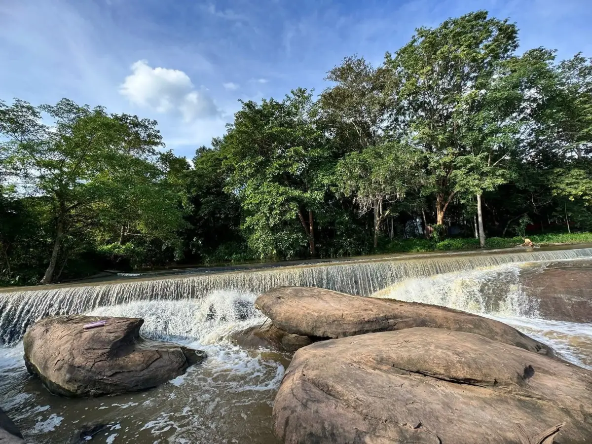
Tat Hin Taek in Nong Bua Lamphu, also commonly referred to as Tat Hin Taek Waterfall, is a natural rock-and-stream attraction in the Phu Kao area at Ban Chai Mongkhon, Moo 9, Khok Muang Subdistrict, Non Sang District. The site is known for a large rock field where a natural stream flows across fractured stone, creating rock channels, seasonal rapids, shallow cascades, and a quiet forest atmosphere. Unlike fully developed tourist attractions, Tat Hin Taek has not yet been organized as a permanent official tourist site. For this reason, visitors should travel with a local guide or coordinate with people who know the route before entering the area.
The charm of Tat Hin Taek lies in its raw natural character. This is not a large waterfall with a high vertical drop, shops, paved viewpoints, and full facilities. Instead, it is a stream crossing a broad rock platform in the Phu Kao landscape. The rock surface is cracked, uneven, and shaped by flowing water over time. During the rainy season, water moves through the rock channels and turns the area into a seasonal rocky rapid. During drier months, the water level may decrease, revealing the stone layers and fractured surfaces more clearly.
The Thai name explains the place directly. “Tat” is a northeastern Thai word often used for water flowing over rock ledges or low cascade-like sections, while “Hin Taek” means broken or fractured rock. Together, the name describes a natural rock area where water flows across split stone. The identity of the place is therefore created by both water and rock. Without the fractured stone, the stream would be ordinary; without the stream, the rock field would not have the same sense of movement.
Tat Hin Taek is formed by Huai Bong, a natural stream that passes across the rock platform before flowing toward the Lam Phaniang water system. As the stream crosses the rock, it follows cracks and lower sections in the stone. Over time, flowing water, weathering, and the natural weakness of the rock layers have widened the cracks and shaped a broad broken-rock zone. Available waterfall documentation describes the area as having a fractured rock section around 30 meters wide and about 4 meters high, with scattered rocks downstream that become part of the rapid-like landscape during the rainy season.
This makes Tat Hin Taek different from a classic waterfall where water drops dramatically from a tall cliff. Here, the beauty is more horizontal and textural. Visitors see water running across stone, small drops over broken layers, pools between rock sections, and rough surfaces created by erosion. The experience is quiet and observational. It rewards travelers who enjoy looking closely at natural forms rather than expecting a large spectacle.
The site is part of the broader Phu Kao landscape within the Phu Kao-Phu Phan Kham National Park area. Phu Kao is a region of forests, sandstone formations, caves, rock terraces, waterfalls, prehistoric rock art, dinosaur footprints, viewpoints, and Buddhist sites. Tat Hin Taek represents the water-and-rock side of this landscape. Nearby attractions such as Tat Fa Waterfall, Tat Ton Waterfall, Wat Phra Phutthabat Phu Kao, Tham Achan Sim, Tham Muem, Tham Puem, Phu Wat dinosaur footprints, and Sao Hin Ham Tang all help show the diversity of Phu Kao.
Because the area remains natural and is not a fully developed tourist site, visitors should take extra care. Rock surfaces can be slippery, especially where water flows or where algae grows. Some sections may be uneven, cracked, or difficult to cross. Visitors should walk slowly, step only on stable surfaces, avoid running, and avoid standing close to water drops or strong-flow sections. The safest way to enjoy Tat Hin Taek is to observe from secure points and avoid unnecessary risks.
The best season to visit is from the rainy season into the early cool season, when the stream carries enough water to show the beauty of the cascade and rocky channels. In the dry season, the water may be lower, but the structure of the rock platform becomes more visible. Travelers who want flowing water should ask local residents or park-related contacts about current water levels before the trip. Seasonal variation is part of the site’s natural identity.
Route planning is important. Tat Hin Taek is located in the Ban Chai Mongkhon area, the same local zone as Tat Fa Waterfall, but the access route is not a simple permanent tourist route. Some sections may pass through local roads, farm areas, forest paths, or natural ground. A local guide helps visitors find the correct route, avoid unsafe areas, and understand current access conditions. Self-driving without route knowledge is not recommended.
Visitors should prepare carefully. Useful items include shoes with strong grip, drinking water, a hat, light outdoor clothing, insect repellent, a small personal trash bag, and a fully charged phone. During the rainy season, waterproof protection for phones and cameras is also useful. Heavy bags are not recommended because visitors may need to walk over natural rock and uneven ground. The trip should be planned during daylight hours only.
Tat Hin Taek is suitable for travelers who enjoy quiet nature, rock formations, stream scenery, forest routes, and places that are not heavily commercialized. It is not ideal for visitors who expect full facilities or easy roadside access. Children, senior travelers, and visitors with limited mobility should assess the route before entering. If they visit, they should stay close to responsible adults or guides and avoid slippery rock sections.
Photography at Tat Hin Taek works best when water is present and the light is soft. Morning is a good time because the rock surface is easier to see, the air is cooler, and there is enough time to enter and leave safely. Good photo subjects include the fractured rock surface, stream channels, small cascades, pools between rocks, scattered downstream stones, and the surrounding forest. Visitors should never step backward carelessly while taking photos because the rock surface may be uneven.
Environmental care is essential. Since Tat Hin Taek is a stream and rock site inside a natural landscape, litter can quickly damage both the scenery and the water system. Visitors should not leave plastic bags, bottles, food waste, or packaging. They should not scratch rock surfaces, move stones, disturb plants near the stream, or enter unclear forest routes. The place is beautiful because it remains natural, and that quality depends on careful behavior.
Ban Chai Mongkhon plays an important role as the local gateway to Tat Hin Taek and nearby Tat Fa Waterfall. Travelers should respect the community, avoid driving across private farm areas without permission, and ask for directions politely. Community guidance is valuable because local residents know the safest routes, current water conditions, and practical access points better than map applications alone.
Nearby Tat Fa Waterfall is a natural companion to Tat Hin Taek because both are connected with the Ban Chai Mongkhon and Phu Kao area. Tat Fa is known as a small seasonal waterfall with water during the rainy period, while Tat Hin Taek is known for fractured rock and a stream crossing a rock platform. Visiting both helps travelers understand the variety of small water features in the Phu Kao landscape.
Tat Ton Waterfall and Wat Tat Khiriwan can also be added to the route. Tat Ton is another small waterfall and stream area in the Phu Kao region. Including Tat Ton gives visitors a broader picture of how streams flow down from the mountain and pass through temple, forest, and rock landscapes. A nature-focused trip through these points can show several types of water-and-rock scenery in one day.
Wat Phra Phutthabat Phu Kao and Tham Achan Sim add religious and archaeological depth to the trip. The area is associated with Buddhist heritage and ancient symbolic evidence. For travelers interested in culture, combining Tat Hin Taek with these sites transforms the journey from a simple nature visit into a wider exploration of Phu Kao’s natural and cultural layers.
Tham Muem or Tham Puem is another important nearby rock-art site in the Phu Kao area. It is known for prehistoric visual evidence such as red handprints, fish-like forms, geometric marks, and carvings. This helps show that Phu Kao has been meaningful to people for a long time. A route that connects Tat Hin Taek with ancient cave evidence gives travelers a deeper understanding of the landscape.
Sao Hin Ham Tang provides a geological contrast. While Tat Hin Taek shows water cutting across a fractured rock platform, Sao Hin Ham Tang shows rock shaped by long-term weathering into stacked pillar-like forms. Seeing both in the same broader area helps visitors appreciate how different natural processes create different landforms in Phu Kao.
After visiting Tat Hin Taek, travelers can continue to Ho Sawan, Chong Khao Khat Viewpoint, or Hat Non Yao if time allows. Hat Non Yao, also known as Pattaya 3, is a relaxing freshwater beach beside Ubolratana Reservoir. This makes a good afternoon stop after a morning nature route because visitors can rest, eat, and enjoy reservoir views after walking through forest and rock areas.
Food options are not available at Tat Hin Taek itself because it is not a permanent service area. Travelers should eat before entering or plan to eat after leaving the natural site. Practical choices are found in Non Sang District and along the return route, including Khrua Isan Restaurant, made-to-order food shops, local noodle restaurants, Café Amazon Branch 2 Non Sang, and other restaurants closer to town or Ubolratana Reservoir.
Accommodation can be arranged in Non Sang District, around Ubolratana Reservoir, or in Nong Bua Lamphu town. Staying in Non Sang is practical for travelers focusing on Phu Kao, Ban Chai Mongkhon, and nearby natural sites. Staying in Nong Bua Lamphu town provides more restaurants, markets, and urban services. Staying near Ubolratana Reservoir works well for travelers who want to combine Phu Kao nature routes with lakeside relaxation.
For international travelers, Tat Hin Taek offers a rare look at a quiet natural site in upper Isan. It is not a polished destination, and that is part of its value. Visitors can see how small streams, sandstone rock, forest, and local communities form the real landscape of Nong Bua Lamphu. The experience is best for travelers who prefer natural authenticity over convenience.
Overall, Tat Hin Taek in Nong Bua Lamphu is a meaningful natural attraction defined by a broad fractured rock platform, flowing stream, seasonal rapids, forest atmosphere, and the quiet character of Phu Kao. Although it is not yet a fully developed official tourist site, its raw beauty makes it valuable for careful travelers. With preparation, local guidance, and respect for the environment, Tat Hin Taek can become one of the most memorable nature stops in Non Sang District.
Getting There from Nong Bua Lamphu town, travel toward Non Sang District and continue into Khok Muang Subdistrict and Ban Chai Mongkhon, Moo 9, in the Phu Kao area. The route to Tat Hin Taek is not a permanent tourist route, so visitors should coordinate with local guides or Phu Kao-Phu Phan Kham National Park contacts before traveling. Available route descriptions place the waterfall area near the local temple side of Ban Chai Mongkhon. Private transport is the most practical option, and the visit should be made only during daylight hours.
| Name | Tat Hin Taek / Tat Hin Taek Waterfall |
| Location | Ban Chai Mongkhon, Moo 9, Khok Muang Subdistrict, Non Sang District, Nong Bua Lamphu Province |
| Address | Tat Hin Taek Area, Phu Kao Zone, Ban Chai Mongkhon, Moo 9, Khok Muang Subdistrict, Non Sang District, Nong Bua Lamphu Province 39140 |
| Coordinates | Approximately 16.913031, 102.456822 |
| Original Reference Coordinate | UTM 229097E 1871684N |
| Highlights | Large rock platform, stream flowing through fractured stone, seasonal rocky rapids, natural rock channels, Phu Kao forest atmosphere, and an undeveloped nature setting |
| History | A natural rock-and-stream site in the Phu Kao area, formed by Huai Bong flowing over fractured rock and gradually shaping a broad broken-stone cascade and seasonal rapid landscape |
| Name Origin | The name describes water flowing across fractured rock; “tat” refers to water crossing rock ledges or low cascade-like areas, while “hin taek” means broken rock |
| Distinctive Features | A broad fractured rock zone about 30 meters wide and around 4 meters high, with downstream scattered rocks that become rapid-like during the rainy season |
| Travel Information | Travel from Nong Bua Lamphu town toward Non Sang District, then continue into Khok Muang Subdistrict and Ban Chai Mongkhon. The access route is not a permanent tourist route and should be done with local guidance |
| Current Status | Open as a natural rest and rock-stream attraction in the Phu Kao area, but not fully developed as a permanent official tourist site |
| Open Days | Daily |
| Opening Hours | 08.00 – 17.00 |
| Admission Fee | Located in relation to the Phu Kao-Phu Phan Kham National Park area. Park entrance fees: Thai adult 20 baht, Thai child 10 baht / foreign adult 100 baht, foreign child 50 baht |
| Facilities | The site itself is not a permanent tourist facility. Visitors should prepare their own drinking water and basic outdoor items, and should ask local guides or park-related contacts before traveling |
| Main Areas / Zones | 1. Ban Chai Mongkhon access zone 2. Temple-side starting area and local route zone 3. Huai Bong stream zone 4. Fractured rock platform zone 5. Seasonal rapid and pool zone 6. Downstream scattered-rock zone 7. Phu Kao forest and natural-route zone |
| Caretaker / Related Organization | Phu Kao-Phu Phan Kham National Park, Department of National Parks, Wildlife and Plant Conservation, together with Khok Muang local authorities and Ban Chai Mongkhon community |
| Main Contact Number | Phu Kao-Phu Phan Kham National Park, Tel. 063-648-4821 / Khok Muang Subdistrict Administrative Organization, Tel. 0-4231-5801 |
| Visitor Conduct | Travel with a guide, stay on the route, do not climb slippery rocks, do not enter strong-current sections, do not litter, do not scratch rocks, and leave the area before evening |
| Nearby Tourist Attractions | 1. Tat Fa Waterfall, Ban Chai Mongkhon, about 2 km 2. Tat Ton Waterfall / Wat Tat Khiriwan, about 18 km 3. Wat Phra Phutthabat Phu Kao / Tham Achan Sim, about 20 km 4. Tham Muem / Tham Puem Prehistoric Rock-Art Site, about 21 km 5. Phu Wat Dinosaur Footprints, about 25 km 6. Sao Hin Ham Tang, about 25 km 7. Ho Sawan, Phu Kao-Phu Phan Kham National Park, about 35 km 8. Hat Non Yao / Pattaya 3, about 40 km |
| Nearby Restaurants | 1. Khrua Isan Restaurant, Non Sang, about 22 km, Tel. 042-375-004 2. Made-To-Order Food & Coconut Smoothie Restaurant, Ban Kho, Non Sang, about 23 km, Tel. 082-609-8064 3. Kuai Tiao Kai Mara Nong Tun, Kut Du, about 24 km, Tel. 083-459-8955 4. Café Amazon Branch 2 Non Sang, about 25 km, Tel. 081-380-1665 5. Phung Kang Nong Bua Lamphu, about 45 km, Tel. 097-318-7088, 088-052-1334 6. Varee Valley Resort and Restaurant, Ubolratana, about 45 km, Tel. 089-777-1400 |
| Nearby Accommodations | 1. Muji House Resort, Non Sang, about 24 km, Tel. 083-218-2749 2. Oranee Resort, Non Sang, about 26 km, Tel. 081-118-2500 3. Varee Valley Resort and Restaurant, Ubolratana, about 45 km, Tel. 089-777-1400 4. Ruean Chor Fah Hotel, Nong Bua Lamphu, about 55 km, Tel. 095-658-5544, 042-311-139 5. Rungrod Grand Hotel, Nong Bua Lamphu, about 55 km, Tel. 093-321-1199 |
Frequently Asked Questions (FAQ)
Q: Where is Tat Hin Taek located?
A: Tat Hin Taek is located in the Phu Kao area at Ban Chai Mongkhon, Moo 9, Khok Muang Subdistrict, Non Sang District, Nong Bua Lamphu Province.
Q: What are the opening hours of Tat Hin Taek?
A: The site is listed as open daily from 08.00 to 17.00. Visitors should enter only during daylight hours and with local guidance.
Q: Is there an admission fee?
A: The site is related to the Phu Kao-Phu Phan Kham National Park area. Park entrance fees are 20 baht for Thai adults, 10 baht for Thai children, 100 baht for foreign adults, and 50 baht for foreign children.
Q: What is the main highlight of Tat Hin Taek?
A: The main highlight is the large fractured rock platform where a natural stream flows through broken stone, forming seasonal rapids, rock channels, and small cascade-like sections.
Q: When is the best time to visit Tat Hin Taek?
A: The rainy season to early cool season is the best period because the stream carries enough water to show the beauty of the rock channels and seasonal rapids.
Q: Can travelers visit Tat Hin Taek without a guide?
A: Visitors should travel with a local guide or coordinate with park-related contacts because the site is not a permanent tourist facility and the route may not be clearly marked.
Q: What should travelers prepare before visiting?
A: Travelers should bring shoes with good grip, drinking water, a hat, insect repellent, a personal trash bag, and a fully charged phone, and should plan to leave the area before evening.
Q: What nearby attractions can be visited with Tat Hin Taek?
A: Nearby attractions include Tat Fa Waterfall, Tat Ton Waterfall, Wat Phra Phutthabat Phu Kao, Tham Achan Sim, Tham Muem, Tham Puem, Phu Wat Dinosaur Footprints, Sao Hin Ham Tang, Ho Sawan, and Hat Non Yao.
 Category: ●Nature and Wildlife
 Group: ●Other natural attractions
Last Update : 2 MonthAgo
 Last Update : 2 MonthAgo
 Click to Access the Navigation Map GPS
 Art, Culture and Heritage
 Historical Sites and Monuments(4)
 Landmarks and Memorials(1)
 Art, Craft Centres, Tradition(1)
 Museums(3)
 Places of Worship
 Temple(10)
 Other Sacred Sites(6)
 Suburban Living
 Village, Community(3)
 National Parks and Marine Reserves(3)
 Mountain (Doi)(5)
 Dam, Reservoir, Lake(5)
 Waterfalls(1)
 Caves(6)
 River, Canal(2)
 Bays and Beaches(1)
Other natural attractions(3)
Bays and Beaches(1)
Other natural attractions(3)


