
lovethailand home >Northeastern Travel Attractions >Nakhon Ratchasima Travel Attractions >Si Khui >Nong Ya Khao > Khao Sadao
TL;DR: Khao Sadao is located at Ban Nong Han, Moo 10, Nong Ya Khao Subdistrict, Sikhio District, Nakhon Ratchasima Province 30140, open Daily, hours 08.00 – 17.00.
Khao Sadao
Open Days: Daily
Opening Hours: 08.00 – 17.00
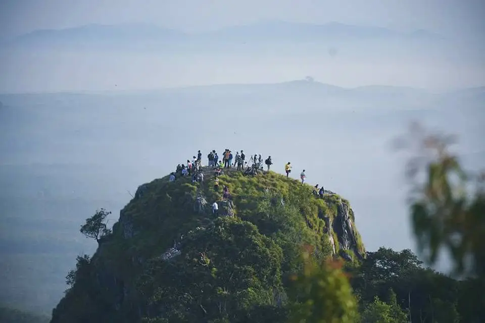
Khao Sadao is located at Ban Nong Han, Moo 10, Nong Ya Khao Subdistrict, Sikhio District, Nakhon Ratchasima Province 30140. It is an adventure-oriented mountain viewpoint and one of Thailand’s recognized paragliding locations. The site is known among pilots as a natural flying area with an open ridge, a west-facing wind channel, broad sky exposure, and panoramic views toward Lam Takhong Dam. Unlike a commercial theme attraction, Khao Sadao is defined by mountain terrain, wind, open space, rural scenery, and its role as a temporary air-sports field for paragliding activities.
The identity of Khao Sadao comes from the meeting point of landscape and airflow. The mountain is not extremely high when compared with major peaks, but its shape, ridge alignment, and wind exposure create conditions that make it valuable for paragliding. The western side of the mountain forms a wind corridor, while the upper slope and takeoff area provide an open space for pilots. These natural conditions are the reason Khao Sadao has become known in Thailand’s paragliding community.
The site belongs to the rural landscape of Nong Ya Khao Subdistrict in Sikhio District. Around the mountain are villages, farmland, open fields, local roads, and views of the broader western Korat landscape. This local setting gives Khao Sadao a different character from heavily developed viewpoints or resort-based attractions. Visitors experience a mountain connected directly with village life, agricultural land, and the wide geography of Sikhio rather than a closed tourism complex.
Khao Sadao is also known internationally in paragliding databases as Khao Sadao or Sik Hiu Khao Sadao. The takeoff coordinate is listed around 14.918461, 101.603104, with a takeoff altitude of about 489 meters above sea level. The peak itself is recorded at about 576 meters above sea level. These figures show that the site has enough elevation to provide a wide view and a useful height difference for paragliding activity, especially when combined with favorable wind.
The flying character of Khao Sadao is shaped by ridge lift and wind direction. The takeoff area generally relates to wind from the south to southwest, and the mountain form allows pilots to use the ridge and lift created by moving air. Pilots can fly along the ridge, gain height from thermal activity, and begin cross-country routes under suitable conditions. The site is therefore not just a scenic hilltop; it is a working natural air-sports landscape where topography and weather create the flying experience.
Khao Sadao’s importance has been reinforced by organized flying events. In 2025, Nakhon Ratchasima Province prepared the PWCA Asian Tour 2025 Thailand – AFA Cross Country Asian League and Khao Sadao XCamp 2025 at the temporary air-sports field of Khao Sadao in Sikhio District. This shows that the site remains active and relevant in the paragliding community. Its use for international-level flying activities gives Khao Sadao a clear role in adventure tourism and air sports in Nakhon Ratchasima.
For pilots, Khao Sadao is a place that requires an understanding of wind, weather, terrain, takeoff, landing zones, and flight planning. For non-flying visitors, the mountain offers the experience of watching paragliders prepare, launch, and move across the sky above the ridge. Seeing colorful wings lifting from the slope and gliding over the rural landscape gives the place a strong visual identity. This combination of sport and scenery makes Khao Sadao distinctive among travel spots in Sikhio.
Paragliding is a specialized aviation sport that depends on equipment, skill, safety procedures, wind conditions, and coordination with experienced pilots or organizers. At Khao Sadao, flying activity is connected with clubs, pilot groups, training trips, and organized events rather than constant amusement-ride operation. The mountain remains open as a viewpoint and adventure area during listed hours, while flying activity follows the conditions and organization of each day or event.
The shape of Khao Sadao gives the site its practical strength. The ridge runs across the landscape, the takeoff area is open, and the surrounding lower ground provides landing possibilities. Some paragliding information describes the site as having alternative landing areas in front of the takeoff area and around nearby open ground. This combination of takeoff, ridge, airflow, and landing terrain makes Khao Sadao suitable for both practice and cross-country flying under appropriate conditions.
For Sikhio District, Khao Sadao adds a unique adventure identity. Sikhio is widely associated with Mittraphap Road, Lam Takhong Dam, Wat Non Kum or Luang Por To Temple, rest stops, farms, and the route toward Pak Chong. Khao Sadao adds sky, wind, mountain flight, and air sports to that regional image. It changes Sikhio from a pass-through district into a place with a recognizable adventure landmark.
The landscape view from Khao Sadao is wide and open. From the western side of the mountain, visitors can see the direction of Lam Takhong Dam, the flatlands of Sikhio, village areas, agricultural fields, road corridors, and distant hills. The view gives a clear sense of western Korat’s geography. It shows the relationship between mountain, reservoir, highway, farmland, and rural settlement in one continuous scene.
Lam Takhong Dam is the most important visual reference connected with Khao Sadao. The dam and reservoir are strongly associated with Sikhio and Mittraphap Road, and the ability to see this water landscape from the mountain adds value to the viewpoint. The view connects two important parts of Sikhio: the water body below and the flying ridge above. Together they create a strong natural image of the district.
Ban Nong Han and Nong Ya Khao Subdistrict are part of the site’s local meaning. Reaching Khao Sadao involves leaving the main highway, entering local roads, and moving through a rural community before reaching the mountain. This gradual transition from highway to village and from village to ridge is part of the experience. It shows that Khao Sadao is not isolated from local life but rooted in the surrounding community.
The listed opening information for Khao Sadao is daily from 08.00 to 17.00. General entry for viewing the area is free. Paragliding activity is separate from ordinary sightseeing because it depends on pilot groups, clubs, event organizers, wind, equipment, and safety conditions. The site therefore has two main layers of use: a mountain viewpoint for general visitors and a specialized takeoff area for trained or organized paragliding activity.
The main zones of Khao Sadao can be understood by function: the access road zone, the hilltop area, the paragliding takeoff zone, the western wind channel zone, the Lam Takhong viewpoint zone, the spectator area for paragliding, the lower landing area, and the Ban Nong Han community zone. These are not formal retail zones. They are functional areas shaped by the mountain, wind, aviation use, and the surrounding community.
The paragliding takeoff zone is the core of the site. It is an open area on the ridge where pilots prepare their wings, inspect equipment, wait for wind, and launch from the slope. The area requires open ground and favorable wind exposure. During events, this zone becomes active with pilots, retrieve teams, flight briefings, and organized takeoff sequences. It is the place where Khao Sadao’s identity as an air-sports field becomes most visible.
The western wind channel is the natural element that makes the site important. Wind moving against the slope and ridge creates lift that allows paragliders to remain airborne and travel along the mountain. This interaction between air and landform gives Khao Sadao its flying character. Without the wind corridor and ridge shape, the mountain would be only a viewpoint; with them, it becomes a paragliding site.
The Lam Takhong viewpoint zone gives non-flying visitors a direct landscape experience. From this area, the reservoir, hills, agricultural land, and parts of the wider Sikhio district can be seen from above. The view is especially memorable because it combines water and mountain scenery. It also gives visitors a clearer understanding of why western Nakhon Ratchasima has long been associated with roads, dams, hills, and travel stops.
The spectator zone for paragliding allows visitors to watch the sky activity from the mountain area. When pilots are present, the process of laying out wings, checking lines, lifting the canopy, and launching into the air becomes part of the site experience. The visual contrast between colorful gliders and the rural background gives Khao Sadao a strong identity for photography and adventure travel.
The lower landing zone is part of the flight system. Open areas below the mountain allow pilots to finish flights and return to transport arrangements. During organized events, landing, retrieval, and transport back to the takeoff area are managed as part of the flying operation. This shows that Khao Sadao functions as a complete flying landscape, not just a single viewpoint on top of a hill.
The Ban Nong Han community zone connects the flying site with local settlement. Pilots and visitors pass through or near local roads and community areas before reaching the mountain. This connection gives local residents and agencies a role in the site’s tourism identity. The name Ban Nong Han and Nong Ya Khao Subdistrict have become linked with Khao Sadao through its paragliding reputation.
Getting There uses Mittraphap Road as the main route. From Bangkok, travel through Saraburi, Muak Lek, Pak Chong, and then toward Sikhio District. From Nakhon Ratchasima city, travel along Mittraphap Road toward Sikhio. After reaching Sikhio, enter the local road network toward Nong Ya Khao Subdistrict and Ban Nong Han, Moo 10. The final access to the mountain uses local roads leading toward the takeoff and viewpoint area.
Public transport connects more naturally with Sikhio town and Ban Mai Samrong Railway Station, which is relatively close to the broader Khao Sadao area. However, the hilltop and takeoff zone require private or locally arranged transport because the mountain is away from the main road and ordinary public transport does not run directly to the top. During events, transport and retrieval are usually arranged by the pilot group or organizers.
Facilities at Khao Sadao are simple and outdoor-oriented. The key facilities are the takeoff area, viewpoint, access route, open ground, parking points used by the community or event organizers, and space for watching paragliding. The site does not operate like a large commercial attraction with permanent buildings and shops on every zone. Its value lies in the natural ridge, wind, view, and air-sports use.
Nearby attractions around Sikhio and Lam Takhong help connect Khao Sadao with a broader travel route. Lam Takhong Dam, Khao Yai Thiang viewpoint, Wat Non Kum or Luang Por To Temple, Suwan Corn Farm, Mountain Creek Golf Resort & Residences, Farm Chokchai, Pak Chong town, and Khao Yai National Park are all part of the wider western Korat travel landscape. These places add reservoirs, temples, farms, golf resorts, town life, and national-park access to the Khao Sadao route.
Lam Takhong Dam is the closest major scenic reference. It is a reservoir and viewpoint area in Sikhio District and has long been associated with Mittraphap Road. Khao Yai Thiang adds another ridge-and-wind landscape, known for views and open hills. Wat Non Kum or Luang Por To Temple gives the route a major religious landmark along the highway. Together, these nearby places give Sikhio a layered identity: water, wind, temple, road, and mountain.
Food options near Khao Sadao are mainly found in local villages, Sikhio town, and along Mittraphap Road. Restaurants and cafés include local food shops around Nong Ya Khao, M Coffee Sikhio, Nut Suki Sikhio, Jam Shop Sikhio, PunThai Coffee on the Sikhio town road, Term Wan Roti Sikhio, Khrua Saen Suk Sikhio, and Farm Chokchai Steakhouse farther toward Pak Chong. These places serve travelers visiting the mountain, driving through Sikhio, or continuing toward Lam Takhong and Pak Chong.
Accommodation near Khao Sadao is found in Sikhio, Lam Takhong, and Pak Chong zones. Options include small local stays around Sikhio and Nong Ya Khao, Mountain Creek Golf Resort & Residences, Panorama Golf & Country Club or Voyage Panorama Resort & Golf Club, The Green Land Farm, Lam Takhong-area stays, Sikhio town hotels, Pak Chong accommodations, and resorts on the Khao Yai side. These options support pilots, event participants, road travelers, and visitors using Sikhio as a base.
For international travelers, Khao Sadao shows a side of Thailand that is different from beaches, old cities, temples, and night markets. It is a rural mountain used for paragliding, surrounded by farmland and facing a reservoir view. Travelers interested in adventure sports, paragliding, scenic ridges, rural landscapes, and local air-sports culture can understand another dimension of northeastern Thailand through this site.
Khao Sadao has several layers of significance. It is a local mountain viewpoint for Nong Ya Khao. It is a recognized paragliding site for pilots. It is connected with Lam Takhong Dam and the landscape of Sikhio. It has been used for international air-sports events. It also helps link Ban Nong Han and Nong Ya Khao Subdistrict with adventure tourism. These layers make Khao Sadao more than an ordinary hill; it is a wind, sky, and sport landmark of western Nakhon Ratchasima.
In summary, Khao Sadao in Nakhon Ratchasima is an adventure tourism site and paragliding landmark in Ban Nong Han, Moo 10, Nong Ya Khao Subdistrict, Sikhio District. It is open daily from 08.00 to 17.00, with free general entry for viewpoint access. Its main highlights are the ridge takeoff area, the west-facing wind channel, the view of Lam Takhong Dam, the rural landscape of Sikhio, and its role as a temporary air-sports field used for paragliding events. Khao Sadao represents wind, mountain, sky, and western Korat scenery in one distinctive place.
| Name | Khao Sadao |
| Location | Ban Nong Han, Moo 10, Nong Ya Khao Subdistrict, Sikhio District, Nakhon Ratchasima Province 30140 |
| Address | Moo 10, Ban Nong Han, Nong Ya Khao Subdistrict, Sikhio District, Nakhon Ratchasima 30140 |
| Takeoff Coordinates | 14.918461, 101.603104 |
| Highlights | Important paragliding site in Thailand, open ridge takeoff area, west-facing wind channel, Lam Takhong Dam view, Sikhio rural scenery, and temporary air-sports field used for international paragliding events |
| Type | Adventure Tourism Site, Mountain Viewpoint, Paragliding Takeoff Area, And Air-Sports Landscape In Sikhio District |
| Elevation | Takeoff Area About 489 Meters Above Sea Level / Khao Sadao Peak About 576 Meters Above Sea Level |
| Landscape | Open hill and ridge landscape with a west-facing wind corridor, continuous airflow, views of Lam Takhong Dam, and wide scenery across Sikhio District |
| History / Significance | An adventure tourism site used by Thai paragliding clubs and pilot groups as a flying area. It has served as a temporary air-sports field for international paragliding activities in Sikhio District |
| Name Origin | The name Khao Sadao refers to the mountain in the Ban Nong Han and Nong Ya Khao area and is known in both Thai and English paragliding circles as Khao Sadao |
| Travel Information | Use Mittraphap Road to Sikhio District, then enter the local route to Nong Ya Khao Subdistrict and Ban Nong Han, Moo 10. From Bangkok, travel through Saraburi, Muak Lek, Pak Chong, and Sikhio. From Nakhon Ratchasima city, use Mittraphap Road toward Sikhio |
| Current Status | Open as an adventure tourism site, viewpoint, and paragliding activity area in Sikhio District |
| Open Days | Daily |
| Opening Hours | 08.00 – 17.00 |
| Admission Fee | Free General Entry For Viewpoint Access. Paragliding is a specialized activity operated according to clubs, organizers, and wind conditions |
| Facilities | Paragliding takeoff area, Lam Takhong Dam viewpoint, open ridge area, access road, parking areas used by the community or event organizers, and spectator space for paragliding activity |
| Main Areas / Zones | 1. Mountain Access Zone 2. Hilltop Zone 3. Paragliding Takeoff Zone 4. Western Wind Channel Zone 5. Lam Takhong Dam Viewpoint Zone 6. Paragliding Spectator Zone 7. Lower Landing Area 8. Ban Nong Han Community Zone |
| Caretaker / Coordinator | Nong Ya Khao Subdistrict Administrative Organization / Ban Nong Han Community / Paragliding club network and air-sports event organizers |
| Contact Number | Nong Ya Khao Subdistrict Administrative Organization Tel. 044-081-247 |
| Nearby Tourist Attractions | 1. Lam Takhong Dam – About 15 Km – Tel. 044-323-144 2. Khao Yai Thiang Viewpoint – About 20 Km 3. Wat Non Kum / Luang Por To Temple, Sikhio – About 25 Km – Tel. 089-584-4966 4. Suwan Corn Farm – About 35 Km 5. Mountain Creek Golf Resort & Residences – About 25 Km – Tel. 044-756-100 To 044-756-105 6. Farm Chokchai – About 42 Km – Tel. 086-328-0189 7. Pak Chong Town – About 50 Km 8. Khao Yai National Park, Pak Chong Entrance – About 70 Km – Tel. 086-092-6531 |
| Nearby Restaurants | 1. Local Food Shops In Ban Nong Han And Nong Ya Khao – About 1–5 Km 2. M Coffee Sikhio – About 18 Km – Tel. 044-411-913 3. Nut Suki Sikhio – About 24 Km – Tel. 092-884-9993, 081-389-4300 4. Jam Shop Sikhio – About 23 Km – Tel. 081-265-1722 5. PunThai Coffee Sikhio Town Road – About 23 Km – Tel. 061-386-2843 6. Term Wan Roti Sikhio Branch 1 – About 23 Km – Tel. 096-897-3835 7. Khrua Saen Suk Sikhio – About 25 Km – Tel. 081-365-9785 8. Farm Chokchai Steakhouse Pak Chong – About 42 Km – Tel. 086-328-0189 |
| Nearby Accommodations | 1. Local Stays Around Sikhio And Nong Ya Khao – About 15–25 Km 2. Mountain Creek Golf Resort & Residences – About 25 Km – Tel. 044-756-100 To 044-756-105, 088-885-3782, 094-889-8869 3. Panorama Golf & Country Club / Voyage Panorama Resort & Golf Club – About 28 Km – Tel. 044-230-276 4. The Green Land Farm Sikhio – About 35 Km 5. Lam Takhong Area Accommodations – About 18–25 Km 6. Sikhio Town Accommodations – About 23–28 Km 7. Pak Chong Area Accommodations – About 50 Km 8. Khao Yai, Pak Chong Side Accommodations – About 65–75 Km |
Frequently Asked Questions (FAQ)
Q: Is Khao Sadao currently open?
A: Khao Sadao is currently open as an adventure tourism site, mountain viewpoint, and paragliding activity area in Sikhio District, Nakhon Ratchasima.
Q: What are the opening days and hours?
A: Khao Sadao is open daily from 08.00 to 17.00.
Q: Where is Khao Sadao located?
A: Khao Sadao is located at Ban Nong Han, Moo 10, Nong Ya Khao Subdistrict, Sikhio District, Nakhon Ratchasima Province 30140.
Q: Is there an admission fee?
A: General entry for viewpoint access is free. Paragliding is a specialized activity operated according to clubs, organizers, and wind conditions.
Q: What is Khao Sadao famous for?
A: Khao Sadao is famous for paragliding, its ridge takeoff area, west-facing wind channel, Lam Takhong Dam view, and wide scenery across Sikhio District.
Q: Is Khao Sadao really a paragliding site?
A: Yes. Khao Sadao is listed in local tourism and paragliding sources as a paragliding takeoff area and has been used as a temporary air-sports field for international paragliding activities.
Q: What can visitors see from Khao Sadao?
A: Visitors can see mountain ridges, Sikhio’s rural landscape, villages, open fields, Mittraphap Road corridors, and Lam Takhong Dam from a wide viewpoint.
Q: What attractions are near Khao Sadao?
A: Nearby places include Lam Takhong Dam, Khao Yai Thiang Viewpoint, Wat Non Kum or Luang Por To Temple, Suwan Corn Farm, Mountain Creek Golf Resort & Residences, Farm Chokchai, Pak Chong town, and Khao Yai National Park on the Pak Chong side.
 Category: ●Nature and Wildlife
 Group: ●Mountain (Doi)
Last Update : 3 MonthAgo
 Last Update : 3 MonthAgo
 Click to Access the Navigation Map GPS
 Art, Culture and Heritage
 Historical Sites and Monuments(20)
 Landmarks and Memorials(5)
 Art, Craft Centres, Tradition(7)
 Museums(6)
 Art Gallery(1)
 Educational Places
 Educational Gardens, Farm(4)
 Places of Worship
 Temple(29)
 Mosque(1)
 Other Sacred Sites(6)
 Research and Development
 Royal Project(3)
 Suburban Living
 Village, Community(6)
 Local Market(4)
 Floating Market(1)
 National Parks and Marine Reserves(3)
Mountain (Doi)(5)
National Parks and Marine Reserves(3)
Mountain (Doi)(5)
 Dam, Reservoir, Lake(8)
 Waterfalls(9)
 Hot Springs(1)
 Caves(2)
 Flower Field(1)
 River, Canal(8)
 Bays and Beaches(2)
 Other natural attractions(3)
 Entertainment and Agricultural
 Zoos and Aquariums(2)
 Animal camps and shows(1)
 Farms, Parks and Ecotourism(21)
 Waterpark(4)
 Outdoor and Adventure Activities(6)
 Shopping
 Shopping and Night Market(2)
 Travel Articles, Recipes
 Travel Review, Food Review(6)


