
lovethailand home >Northeastern Travel Attractions >Nakhon Ratchasima Travel Attractions >Bua Yai >Don Ta Nin > Prang Ku
TL;DR: Prang Ku is located at Temple grounds at Ban Ku, Moo 4, Don Tanin Subdistrict, Bua Yai District, Nakhon Ratchasima Province, open Daily, hours 08.00 – 17.00 is the recommended period for visiting this open-air site.
Prang Ku
Open Days: Daily
Opening Hours: 08.00 – 17.00 is the recommended period for visiting this open-air site
Admission Fee: Free admission
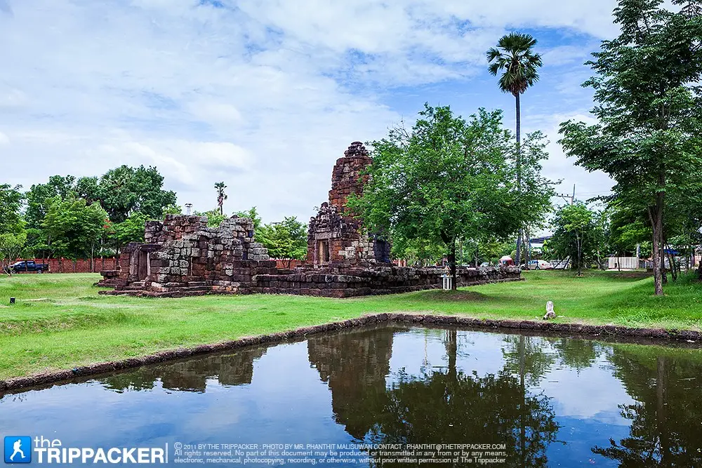
Prang Ku at Ban Ku, officially recorded as Ku Ruesi Ban Ku or Ku Ban Khu, is a small archaeological monument situated within the grounds of the temple at Ban Ku, Moo 4, Don Tanin Subdistrict, Bua Yai District, Nakhon Ratchasima Province. Its most visible feature is a square foundation constructed from rectangular laterite blocks, surrounded by fallen architectural material and several mature trees. The monument no longer retains a tall superstructure or the elaborate decorative elements associated with better-preserved Khmer sanctuaries such as Phimai. Nevertheless, the remaining foundation is important evidence of the historical landscape of northern Nakhon Ratchasima. It demonstrates that ancient religious architecture was not limited to monumental urban temples but also included smaller structures established within local settlements and along regional communication routes.
The monument appears under several names, including Prang Ku, Prang Ban Ku, Ku Ban Ku, Ku Ban Khu, and Ku Ruesi Ban Ku. The official cultural-environment database uses Ku Ruesi Ban Ku, with Ku Ban Khu as an alternative, while local residents commonly refer to the place more simply as Prang Ku or Prang Ban Ku. These variations do not represent different monuments. They reflect local pronunciation, spelling, and the ways in which different communities and institutions recorded the site. Travelers should always include Ban Ku, Don Tanin Subdistrict, and Bua Yai District in a map search because places called Prang Ku, Ku Ban Ku, and Ku Ruesi exist in several Thai provinces. Searching only for Prang Ku can easily direct visitors to Chaiyaphum, Si Sa Ket, Maha Sarakham, Buriram, or another location.
Local oral history states that nobody knows exactly when the monument was constructed and that its form resembles Phimai Sanctuary and Prang Sida. This tradition is valuable because it reveals how residents of Ban Ku connect their local laterite ruin with well-known ancient monuments in the surrounding region. Similarity in material, the square form of a foundation, or the general appearance of a ruined tower cannot, however, confirm that all three structures were built at the same time. Archaeological dating requires several categories of evidence, including architectural style, sculpture, inscriptions, pottery, soil stratigraphy, masonry technique, and results from controlled excavation.
The official database describes Ku Ruesi Ban Ku as a square-based prang constructed from rectangular laterite blocks. It records visible collapse, the absence of restoration to a complete architectural form, and the growth of several large trees around the remains. The available entry does not assign a definite construction date or artistic period. For this reason, the monument should not be identified conclusively as an arokayasala hospital sanctuary, a structure from the reign of Jayavarman VII, or a building contemporary with Phimai unless a detailed excavation report or new archaeological evidence directly supports such an interpretation. The most accurate current description is a ruined laterite archaeological monument whose construction period remains undetermined in publicly available records.
Uncertainty about the date does not reduce the importance of Prang Ku. A place that has not yet been studied in detail can contain significant questions for future archaeology. Researchers may seek to determine the original dimensions of the building, its orientation, whether it had an enclosure or pond, which sacred image it once housed, how many phases of use occurred, and how it related to nearby ancient settlements. These questions require professional investigation rather than visual speculation. Protecting the ground around the monument is therefore essential because archaeological deposits below the surface may preserve more information than the exposed laterite blocks.
The site is located at Ban Ku, Moo 4, Don Tanin Subdistrict, approximately 10–13 kilometers by road from Bua Yai town and around 80 kilometers from central Nakhon Ratchasima. Its approximate coordinates are 15.495356, 102.467993. The surrounding landscape consists of agricultural plains, village roads, a temple, trees, and cultivated land. Its position within a temple compound maintains a connection with the community's shared public and religious space. Basic care is provided through cooperation among the local temple, residents, the local administrative organization, and heritage officials, although the site does not operate as a formal visitor center with ticket counters and permanent guides.
In northeastern Thai usage, the word ku frequently refers to a sacred building, reliquary, stupa, or ancient tower made from permanent material. Prang generally describes a tall religious tower whose architectural ancestry is connected with ancient Khmer traditions and their later adaptation in Thai art. The combined local name Prang Ku is therefore a practical way of identifying a ruined sacred structure within the community. The name alone cannot determine its original religion, function, or date because the word ku has been applied to Hindu sanctuaries, Mahayana Buddhist monuments, reliquaries, memorial structures, and buildings reinterpreted by later communities.
Laterite is a major construction material at many archaeological sites in northeastern Thailand. It develops in soil and rock layers rich in iron and aluminum. When extracted while still moist, it can be cut into blocks more easily than after prolonged exposure to air, which causes the surface to harden. Ancient builders used laterite for foundations, enclosure walls, paths, and load-bearing elements. Although durable, laterite is porous. Rain, groundwater, roots, biological growth, and temperature changes can gradually erode or split its surface. Touching, climbing, or placing heavy objects on laterite blocks may therefore cause damage even when the effect is not immediately visible.
The square foundation is the most important surviving feature for understanding the plan. A foundation carried the weight of the original building and raised its sacred interior above the surrounding ground. Square plans appear in religious architecture from many periods and cannot establish a date by themselves. Archaeologists must also examine the dimensions of individual blocks, bonding patterns, corner construction, foundation levels, entrance position, associated brick or sandstone fragments, and relationships with surrounding features. A detailed survey might reveal former walls, postholes, paving, or subsidiary structures that are not apparent during an ordinary visit.
The collapsed condition does not imply that the original builders lacked skill. The monument has experienced centuries of rainfall, changing groundwater, soil movement, storms, roots, fire, reuse of building materials, treasure hunting, and later human activity. Once an upper wall or roof lost structural support, the remaining weight would have been distributed unevenly and additional blocks could shift. The scattered laterite around the foundation may therefore record a long sequence of deterioration rather than a single destructive event.
Large trees surrounding the monument provide both value and conservation challenges. Their shade reduces heat, creates a peaceful atmosphere, and has become part of the community's visual memory. Roots, however, can enter masonry joints, displace blocks, and redirect drainage. Falling branches may strike the remains, while accumulated leaves retain moisture and support smaller plants. Tree management must be undertaken by knowledgeable personnel. Visitors and residents should not cut major roots, burn vegetation, or remove trees without professional assessment because an apparently quick solution can damage archaeological soil and masonry more severely than the original problem.
The continued removal of weeds and cleaning by Fine Arts Office 10 in 2026 confirms that the monument remains within the Fine Arts Department's maintenance program. Vegetation clearance is basic but important conservation work. It makes cracks, displaced blocks, animal burrows, and drainage problems easier to detect. Cleaning is not the same as architectural reconstruction. The place continues to display its surviving laterite foundation and collapsed material rather than a newly rebuilt tower designed to appear complete.
Don Tanin Subdistrict Administrative Organization also plays a role in developing the surrounding area. Local government documents refer to projects involving the old ordination hall at Wat Si Suphon and Prang Ku, including the construction of a multipurpose building. Such development can provide community facilities and improve the visitor environment. Any new construction near an archaeological site must also consider the protected zone, visual setting, drainage, and the possibility of buried evidence. Coordination with the Fine Arts Department before excavation or foundation work is therefore necessary for responsible development.
The local association between Prang Ku and Phimai probably reflects the status of Phimai as the best-known ancient Khmer monument in Nakhon Ratchasima. Communities often use a famous regional landmark to explain a smaller local ruin. Phimai has a complex plan, multiple construction phases, sandstone and laterite architecture, inscriptions, sculpture, and stylistic evidence that permit detailed dating. Ku Ruesi Ban Ku has much more limited exposed evidence. Describing it as similar to Phimai should therefore be understood as a broad community comparison, not proof that the same workshop built both places or that construction occurred in the same year.
Prang Ban Sida is located in Sida District, relatively close to Ban Ku, and is another ancient monument familiar to residents of northern Nakhon Ratchasima. Its surviving laterite architecture and association with ancient Khmer culture explain why local people may consider it contemporary with Prang Ku. Establishing the same date would require a comparison of specific features such as foundation moldings, door frames, lintels, sculpture, orientation, and excavated material rather than laterite construction alone.
Archaeologists use several methods to date a monument. Stylistic analysis compares architecture and sculpture with securely dated examples. Excavation examines soil layers and materials associated with construction, including pottery, metal, coins, and charcoal. Inscriptions may identify a patron, sacred image, religious foundation, or political event. Material and construction analysis can reveal technological patterns. Every method has limitations, so a reliable conclusion normally depends on several forms of evidence agreeing with one another.
Archaeological excavation is not a search for attractive objects. It is a controlled process of recording soil layers and the exact positions of pottery, stone, postholes, hearths, and floors. The location of an object may be as informative as the object itself. If a fragment is removed without documentation, evidence concerning date and function can be lost permanently. Visitors and residents must therefore never dig, probe, or disturb soil around the foundation. Small pieces of brick, pottery, or stone should remain in place and be reported to the responsible authority.
Non-invasive survey can also provide important information. Archaeologists may create measured plans, record elevations, use geographic coordinates, photograph the area from above, employ geophysical instruments, or produce three-dimensional models from overlapping images. These techniques can identify buried alignments and monitor structural change while minimizing disturbance. At Ban Ku, a detailed plan showing the laterite foundation, fallen blocks, trees, paths, and surrounding temple buildings would provide an essential baseline for future conservation.
The absence of a visible inscription or major sculpture does not prove that such objects never existed. They may have been lost, removed, transferred for safekeeping, or remain underground. At the same time, no specific deity, treasure, or ritual object should be invented without evidence. Responsible interpretation distinguishes between what is physically visible, what an official database records, what residents remember, and what specialists propose.
The cultural-environment database records no specific ritual associated with the ku at the time of survey. This distinguishes Ban Ku from some ancient monuments where communities hold annual worship, bathing, or offering ceremonies. Its location within a temple compound nevertheless requires respectful behavior. Visitors should dress appropriately, speak quietly, and avoid interfering with religious activity in nearby temple buildings, even though no regular ritual specifically connected with the ruin has been documented.
There is no formal ticket gate or controlled entrance comparable with a historical park, and general access is free. The recommended visiting period is 08.00–17.00, when daylight makes uneven surfaces visible and a visit is less likely to disturb the temple and village. Night visits are not recommended because lighting, staff presence, and facilities are limited. Roots, fallen laterite, and uneven ground can create a significant risk after dark.
Visitor facilities immediately beside the monument are limited. Travelers should carry drinking water, a hat, an umbrella, insect repellent, and sun protection. Restrooms and parking should be used only where the temple or community has designated them. Vehicles must not be driven or parked on grass near the laterite foundation. Large buses and school groups should contact Don Tanin Subdistrict Administrative Organization in advance to arrange parking and a walking route that does not place pressure on the archaeological area.
The most comfortable time is between 08.00 and 10.30. Temperatures are lower and angled light reveals the texture and joints of the laterite blocks. Late afternoon after 15.30 can be suitable for photography, but visitors should leave before darkness. The cool season from November to February is generally pleasant. March to May can be extremely hot, and prolonged exposure around midday should be avoided.
The rainy season creates a green setting and deeper shade, but soil and grass may become soft, wet, or slippery. Footwear with good grip is recommended. Visitors must not climb the foundation or step on wet laterite. Pressure on saturated and weathered material increases the risk of surface loss. Temporary barriers installed during maintenance or inspection must always be respected.
Photography is possible from the normal walking area without climbing or rearranging stones. Tripods should stand on stable ground and must not obstruct monks or residents. Drone operation requires permission and must respect the privacy of the temple and nearby houses. Images from other monuments should never be used to represent Ban Ku because repeated place names make misidentification common. Incorrect photographs can spread rapidly online and create a false understanding of the site.
Families can use Prang Ku as an outdoor classroom. Children may observe the square foundation, the color and porous texture of laterite, evidence of collapse, and the impact of trees on masonry. Adults can explain that archaeology begins not with mysterious speculation but with questions, careful recording, and comparison with reliable evidence. Children must not climb the blocks or take fragments home, even when an object appears small and unimportant.
Schools should divide learners into small groups to reduce trampling and allow careful observation. Activities can include drawing a simple plan, determining direction with a compass, identifying construction materials, recording vegetation, and discussing how trees and archaeological remains might be conserved together. Groups should contact Fine Arts Office 10 or Don Tanin Subdistrict Administrative Organization before traveling to obtain current information and determine whether maintenance work is scheduled.
Older travelers and people with limited mobility can view the general monument from the surrounding open area, but sections consist of soil, grass, and exposed roots. Continuous modern ramps are not available. A companion and stable footwear are advisable, especially during the rainy season. Future accessibility improvements should use raised or reversible designs that do not damage archaeological deposits below the ground.
Visitors must not climb, sit, stand, or place luggage on the laterite foundation. Writing on blocks, hammering nails, tying cloth tightly around masonry, lighting incense or candles directly on the ruin, and applying cleaning chemicals are prohibited conservation practices. Repeated minor contact can remove original surfaces and alter archaeological evidence. Worship and merit-making should take place only in areas designated by the temple.
If a block has moved, a crack has appeared, a tree has fallen, soil has been dug, or someone is removing material, visitors should document the situation from a safe distance and contact Fine Arts Office 10 or Don Tanin Subdistrict Administrative Organization. They should not attempt to lift or replace a block themselves because its position before and after movement must be recorded by specialists.
Getting There from Bua Yai town requires following local roads toward Don Tanin Subdistrict and Ban Ku. The distance is approximately 12 kilometers and the journey generally takes 15–25 minutes. Search for Ku Ruesi Ban Ku or enter the coordinates 15.495356, 102.467993, confirming that the destination is in Don Tanin Subdistrict, Bua Yai District. A search for Prang Ku alone may produce results in other provinces.
From central Nakhon Ratchasima, follow Highway 2, Mittraphap Road, toward Bua Yai, then use Highway 202 and local roads into Don Tanin Subdistrict. The total journey is approximately 80 kilometers and usually takes 1 hour 20 minutes to 1 hour 45 minutes, depending on the starting point, traffic, and route selected by the navigation system. Travelers should check fuel and vehicle condition before continuing through rural roads, particularly when combining the trip with Prang Ban Sida or Prasat Nang Ram.
Rail travelers can arrive at Bua Yai Junction, a major connection on Thailand's northeastern railway network. From the station, a hired vehicle, rental car, or transfer arranged by the accommodation is required because no frequent tourist bus runs directly to the monument. The fare, waiting period, and return journey should be agreed in advance. A private car or vehicle with a driver is the most convenient option when visiting several archaeological sites.
The route from Bua Yai passes through villages and agricultural land. Drivers should reduce speed, watching for motorcycles, farm vehicles, livestock, and pedestrians. Signs may use Ban Ku, Prang Ku, Ku Ruesi, or Wat Ban Ku. At the temple, vehicles should remain in the designated parking area. Driving close to the laterite foundation for photographs or passenger drop-off may create vibration and pressure on archaeological soil.
A half-day itinerary can begin at Prang Ku in the morning, continue to the old ordination hall at Wat Si Suphon or another cultural place in Don Tanin, and finish with lunch in Bua Yai town. The afternoon can be spent around Bueng Bua Yai or the railway junction. This plan is suitable for travelers who prefer a slow local experience rather than a long-distance circuit.
A full-day archaeological itinerary can combine Ban Ku with Prang Ban Sida and Prasat Nang Ram. Each monument has a different condition, plan, and historical record, illustrating the diversity of ancient religious architecture in northern Nakhon Ratchasima. Similar use of laterite or the shared term prang should never be treated as proof that the buildings are contemporary. Reading the signs and comparing specific features will provide a more meaningful experience.
The old ordination hall at Wat Si Suphon is a nearby place that Don Tanin Subdistrict Administrative Organization has included in local tourism development. The old religious building and Prang Ku represent sacred community spaces from different periods. Visiting both reveals how religious landscapes have been created, reused, and cared for through time. Organized groups should confirm access and temple activities with the local authority.
Ban Sema Yai is another nearby area whose name is associated with sema stones and ancient settlement evidence. Some community archaeological locations are not developed as formal tourist attractions and may lack signs, paths, and permanent staff. Travelers must not enter private land without permission and should contact the relevant local authority or Fine Arts Office before visiting.
Bueng Bua Yai is an important recreation area associated with the identity and name of the town. It is suitable for walking, resting, and taking a break after an archaeological visit. Bua Yai also provides markets, restaurants, fuel, railway services, shops, and accommodation, making it the most practical base for the journey.
Prang Ban Sida in Sida District is promoted as a historical attraction of Nakhon Ratchasima. Visiting it after Ban Ku allows travelers to compare a monument whose architectural form remains more readable with a place surviving primarily as a foundation and collapsed laterite. The use of laterite, entrance orientation, and relationship with a modern temple can be compared, but features from Prang Sida must not be used to invent missing details at Ban Ku.
Prasat Nang Ram, also known as Ku Phram Cham Sin, in Prathai District contains a more complex architectural plan and decorative evidence. It provides another comparison for people interested in ancient Khmer art. The longer route requires sufficient driving time and a check of road conditions before departure.
Most restaurants are located in Bua Yai town, approximately 12–15 kilometers from the monument. Choices include Thai and Chinese food, noodles, steaks, fusion dishes, and cafés. Travelers should telephone individual businesses before visiting because local opening hours may change for holidays, ingredient availability, or community events. The town is also the most convenient location for fuel, drinks, and reliable restroom facilities.
Accommodation in Bua Yai includes small hotels, resorts, private bungalows, and homestays, generally 13–20 kilometers from Prang Ku. Guests should confirm room availability, rates, check-in time, and directions directly. Properties near Bua Yai Junction are convenient for rail travelers, while motorists may prefer resorts outside the central commercial area with more parking.
Using local restaurants, accommodation, shops, and transport services distributes tourism income within Bua Yai. A small monument cannot generate the ticket revenue of a historical park, but it can form part of an itinerary that encourages visitors to spend more time in the district. Development should emphasize accurate information, cleanliness, safety, and respect for community life rather than large decorative structures that compete visually with the original remains.
The value of Prang Ku lies partly in the questions it preserves. Its laterite foundation confirms the former presence of a permanent structure valued by an earlier community. Its location within a temple indicates continuity in the use of sacred space, even though the original function and date remain unresolved. Gaps in knowledge should motivate survey and research rather than encourage invented legends to replace physical evidence.
Future work could include detailed mapping, examination of soil around the foundation, analysis of laterite sources, collection of historic photographs, interviews with older residents, and expert comparison with nearby monuments. Such information would distinguish community memory from material evidence without diminishing either one. Both are important for understanding the full history of the place.
The oral tradition linking the monument with Phimai and Prang Sida should be preserved as part of local memory. It demonstrates how Ban Ku residents explain the antiquity and importance of their heritage. Recording oral tradition together with archaeological interpretation allows readers to understand both the history of the building and the history of how the community has perceived it.
Prang Ku is not a destination for monumental visual spectacle. It is suited to travelers interested in reading subtle traces within a landscape. A laterite block, a foundation line, or a root displacing masonry can reveal construction, deterioration, and relationships between people and place. Visitors who walk slowly, read available information, and avoid expecting a complete tower will gain more than those who stop only for a photograph.
Long-term preservation requires cooperation among the Fine Arts Department, Don Tanin Subdistrict Administrative Organization, the temple, residents, schools, and visitors. Heritage specialists provide conservation standards, local authorities support the surrounding environment and public services, the community monitors daily conditions, and visitors must avoid damage. Respect for these complementary roles will allow this small monument to remain evidence of the past and a learning resource for future generations.
Prang Ku at Ban Ku is significant not because every question has already been answered, but because the surviving evidence makes meaningful questions possible. Its multiple names, community stories, square laterite foundation, collapsed material, mature trees, and present conservation work are all parts of the site's history. Travelers who visit responsibly will encounter a quiet and distinctive form of local heritage while helping preserve an important archaeological landmark of Bua Yai District.
| Name | Prang Ku at Ban Ku |
| Official and Alternative Names | Ku Ruesi Ban Ku, Ku Ban Khu, Ku Ban Ku, Prang Ban Ku |
| Thai Name | ปรางค์กู่ บ้านกู่ / กู่ฤาษีบ้านกู่ |
| Location | Temple grounds at Ban Ku, Moo 4, Don Tanin Subdistrict, Bua Yai District, Nakhon Ratchasima Province |
| Address | Ban Ku, Moo 4, Don Tanin, Bua Yai, Nakhon Ratchasima 30120, Thailand |
| Coordinates | 15.495356, 102.467993 |
| Site Type | Archaeological monument within the Ban Ku temple compound |
| Date and Construction Period | No published evidence currently establishes a definite date or construction period. Community oral history connects the monument with Phimai and Prang Sida, but this is not a confirmed archaeological conclusion. |
| Construction Material | Rectangular laterite blocks |
| Main Characteristics | A square foundation, collapsed laterite material around the base, and several mature trees within the archaeological setting |
| Highlights | A small unrestored laterite monument suitable for learning about archaeological materials, deterioration, conservation, and the historical landscape of Ban Ku |
| Main Areas / Zones | 1. Temple-side entrance area 2. Square laterite foundation 3. Collapsed laterite blocks surrounding the base 4. Mature-tree and root zone near the monument 5. Buffer area between the archaeological remains and active temple buildings |
| Current Condition | Ruined and not reconstructed into a complete building. Fine Arts Office 10 periodically clears vegetation and cleans the surrounding area. |
| Recorded Rituals | No specific ritual associated with the ku was recorded in the cultural-environment survey. |
| Caretaker | Fine Arts Office 10, Nakhon Ratchasima, in cooperation with Don Tanin Subdistrict Administrative Organization, the Ban Ku temple, and the Ban Ku community |
| Open Days | Daily |
| Opening Hours | 08.00 – 17.00 is the recommended period for visiting the open-air area |
| Admission Fee | Free admission |
| Facilities | Parking and restrooms where designated by the temple, an open-air viewing area, and a community multipurpose building. Wheelchair facilities are limited. |
| Recommended Visit Duration | Approximately 45 – 60 minutes |
| Travel Information | Approximately 12 km from Bua Yai town via local roads to Don Tanin and Ban Ku. From Nakhon Ratchasima, follow Highway 2 and Highway 202 for approximately 80 km. Rail travelers can continue by hired vehicle from Bua Yai Junction. |
| Main Contact Numbers | Fine Arts Office 10, Nakhon Ratchasima: +66 44 471 518 Don Tanin Subdistrict Administrative Organization: +66 44 009 806 |
| Official Websites | Fine Arts Office 10, Nakhon Ratchasima Don Tanin Subdistrict Administrative Organization |
| Nearby Tourist Attractions | 1. Old Ordination Hall at Wat Si Suphon, approximately 4 km; Don Tanin Subdistrict Administrative Organization Tel. +66 44 009 806 2. Ban Sema Yai Cultural Area, approximately 8 km; Fine Arts Office 10 Tel. +66 44 471 518 3. Bueng Bua Yai, approximately 13 km; Bua Yai Municipality Tel. +66 44 461 163 4. Prang Ban Sida, approximately 15 km; Fine Arts Office 10 Tel. +66 44 471 518 5. Prasat Nang Ram / Ku Phram Cham Sin, approximately 22 km; Fine Arts Office 10 Tel. +66 44 471 518 |
| Nearby Restaurants | 1. Healthy Home Restaurant, Steak and Drinks, approximately 13 km, Tel. +66 88 956 4247 2. Roy Yim Restaurant Bua Yai, approximately 13 km, Tel. +66 96 953 6632, +66 44 461 640 3. Mame Cafe, approximately 14 km, Tel. +66 96 982 2823, +66 44 462 562 4. Mali Chinese Restaurant, approximately 14 km, Tel. +66 44 461 938 5. Kim Leng Teochew Pork Noodles, approximately 14 km, Tel. +66 44 292 394 |
| Nearby Accommodations | 1. White Orchid Hotel and Homestay Bua Yai, approximately 13 km, Tel. +66 91 019 7926 2. Khao Hom Resort Bua Yai, approximately 14 km, Tel. +66 98 309 1889 3. Bua Yai Resort, approximately 15 km, Tel. +66 87 449 9777 4. Marina Resort Bua Yai, approximately 16 km, Tel. +66 80 166 9549 5. Chomna Resort Bua Yai, approximately 18 km, Tel. +66 80 807 1208 |
Frequently Asked Questions (FAQ)
Q: Where is Prang Ku at Ban Ku located?
A: It is located within the temple grounds at Ban Ku, Moo 4, Don Tanin Subdistrict, Bua Yai District, Nakhon Ratchasima Province, at approximately 15.495356, 102.467993.
Q: What other names are used for the monument?
A: It is also called Ku Ruesi Ban Ku, Ku Ban Khu, Ku Ban Ku, and Prang Ban Ku. These names refer to the same monument in Don Tanin Subdistrict.
Q: Was Prang Ku built at the same time as Phimai Sanctuary?
A: No archaeological evidence currently confirms that the two monuments were constructed in the same period. The connection is part of community oral history rather than an established archaeological conclusion.
Q: How old is Prang Ku at Ban Ku?
A: Publicly available evidence does not yet establish a definite construction date. Reliable dating would require excavation, inscriptions, stylistic evidence, or materials found in a documented soil context.
Q: What can visitors see at the site?
A: The main features are a square laterite foundation, collapsed laterite blocks, mature trees surrounding the remains, and the historical landscape within the Ban Ku temple compound.
Q: What are the opening hours and admission fee?
A: The site can be visited daily without an admission fee. The recommended visiting time is 08.00–17.00 because it is an open-air monument with limited lighting and facilities.
Q: Can visitors climb or touch the laterite structure?
A: Visitors should not climb, sit on, stand on, or move the laterite blocks. Laterite is porous and weathered, and repeated pressure can accelerate deterioration.
Q: How can travelers reach the site from Bua Yai?
A: Follow local roads from Bua Yai town toward Don Tanin Subdistrict and Ban Ku for approximately 12 km. Searching for Ku Ruesi Ban Ku or using the coordinates is recommended to avoid navigation to another place named Prang Ku.
 Category: ●Art, Culture and Heritage
 Group: ●Historical Sites and Monuments
Last Update : 2 MonthAgo
 Last Update : 2 MonthAgo
 Click to Access the Navigation Map GPS
 Historical Sites and Monuments(20)
 Landmarks and Memorials(5)
 Art, Craft Centres, Tradition(7)
 Museums(6)
 Art Gallery(1)
 Educational Places
 Educational Gardens, Farm(4)
 Places of Worship
 Temple(29)
 Mosque(1)
 Other Sacred Sites(6)
 Research and Development
 Royal Project(3)
 Suburban Living
 Village, Community(6)
 Local Market(4)
 Floating Market(1)
 Nature and Wildlife
 National Parks and Marine Reserves(3)
 Mountain (Doi)(5)
 Dam, Reservoir, Lake(8)
 Waterfalls(9)
 Hot Springs(1)
 Caves(2)
 Flower Field(1)
 River, Canal(8)
 Bays and Beaches(2)
 Other natural attractions(3)
 Entertainment and Agricultural
 Zoos and Aquariums(1)
 Animal camps and shows(1)
 Farms, Parks and Ecotourism(21)
 Waterpark(2)
 Outdoor and Adventure Activities(6)
 Shopping
 Shopping and Night Market(2)
 Travel Articles, Recipes
 Travel Review, Food Review(5)


