
lovethailand home >Northeastern Travel Attractions >Nakhon Ratchasima Travel Attractions >Muang Nakhon Ratchasima >Muen Wai > Old Nakhon Ratchasima City Wall
TL;DR: Old Nakhon Ratchasima City Wall is located at Northeastern corner of historic Nakhon Ratchasima, opposite the Wat Sala Loi road curve, open Daily, hours Outdoor public area accessible 24 hours; recommended visiting time 06:00–18:30.

Old Nakhon Ratchasima City Wall
Open Days: Daily
Opening Hours: Outdoor public area accessible 24 hours; recommended visiting time 06:00–18:30
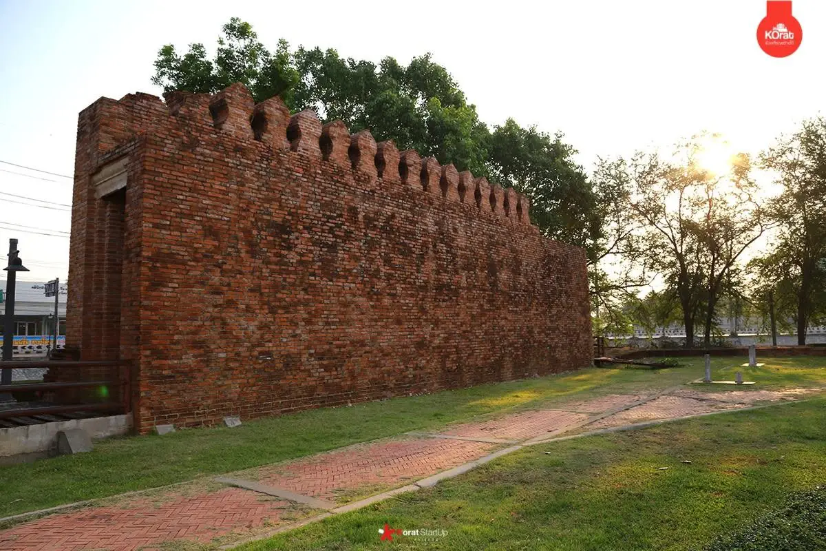
The Old Nakhon Ratchasima City Wall at the Wat Sala Loi corner is a surviving archaeological and reconstructed section of Korat’s former defensive system. It stands on Phon Saen Road at the northeastern corner of the historic city, opposite the bend leading toward Wat Sala Loi in Nai Mueang Subdistrict, Mueang Nakhon Ratchasima District. The wall is now incorporated into a public green space beside the former inner moat. Admission is free, and the outdoor roadside area has no ticket gate. Although it can be approached at any time, daylight between 06:00 and 18:30 is strongly recommended for safety, historical observation, and photography.
The importance of this place does not depend on a fully preserved monumental wall. Its value comes from the archaeological evidence that confirms the actual alignment of the city wall, the corner bastion, and the moat of old Nakhon Ratchasima. A line of laterite blocks discovered in 1998 transformed what had previously been understood mainly through historical texts, maps, and local memory into a physical site that could be excavated and examined. The discovery provides direct evidence of the fortified city beneath modern Korat.
The original information describing Phon Saen Road, the Wat Sala Loi curve, and the Nakhon Ratchasima city-wall restoration project identifies this site as being in Nakhon Ratchasima Province. Travelers should search for “Old Nakhon Ratchasima City Wall,” “Korat Old City Wall at Wat Sala Loi,” or “Phon Saen Road Old City Wall.” Using the complete name prevents confusion with city walls in other Thai provinces and directs navigation to the northeastern corner of the old city.
Nakhon Ratchasima has long occupied a strategic position between the Chao Phraya Basin and the Khorat Plateau. Routes through the area connect central Thailand with Buriram, Surin, Si Sa Ket, Chaiyaphum, Khon Kaen, the Mun River Basin, and territories farther east. Control of the city therefore carried military, administrative, commercial, and logistical importance. A fortified urban center could protect residents, regulate movement, store resources, and function as the principal base for governing the northeastern frontier.
The name Nakhon Ratchasima appeared in Ayutthaya-period records and is commonly associated with two earlier settlements: Sema and Khorakhapura, or Khorakha. Both were significant communities on the Khorat Plateau before the establishment of the present city. Combining their names may have helped preserve the prestige and memory of older centers while creating a new administrative capital in a location better suited to transport, defense, and regional control.
During the reign of King Narai the Great, Nakhon Ratchasima was planned and developed as a major fortified city at its present location. The historic plan formed a rectangle approximately 1,000 meters wide and 1,700 meters long, enclosing an area of around 1,000 rai. Roads, gates, walls, bastions, and moats were arranged for defense and administration. Some aspects of the plan have been associated with European fortress engineering introduced to Ayutthaya through international contact during the 17th century.
The original city wall enclosed all four sides of the urban area and extended for more than five kilometers. It was constructed primarily from brick above a substantial foundation and included battlements and approximately 15 bastions at strategic points. These defensive projections allowed guards to observe and protect the wall between the principal gates. Bastions positioned at corners and along exposed stretches reduced blind areas and improved the defenders’ ability to respond to anyone approaching the wall.
A moat formed the outer defensive line. Water slowed soldiers, animals, and siege equipment before they could reach the brick wall. The moat also participated in the city’s water-management system by receiving rainwater, maintaining moisture, and supporting urban needs during certain periods. The fortified system must therefore be understood as a complete landscape of water, walls, roads, gates, bastions, and open ground rather than as a single vertical barrier.
Nakhon Ratchasima had four principal gates. Chumphon Gate stood on the west and is now the best-known surviving symbol of old Korat. Phon Saen Gate, also called the Water Gate, stood on the north. Phon Lan Gate was positioned on the east, and Chai Narong Gate served the south. Each gateway connected the enclosed city to regional roads, agricultural land, neighboring settlements, and commercial routes. The gate names remain visible in street names, districts, historical narratives, and local memory.
The wall near Wat Sala Loi occupied the northeastern corner of the city and was therefore associated with both the northern and eastern defensive lines. A corner required stronger construction than an ordinary straight wall because it joined two directions and could be approached from a wider field. A bastion at this position allowed guards to observe both sides, protect the junction, and reduce the blind angle created by the turn of the wall.
Phon Saen Gate on the northern side was historically connected to drainage and water movement, which explains its alternative name, the Water Gate. Modern Phon Saen Road preserves the old name. Following the road and the moat landscape therefore allows visitors to read the historic city through surviving place names, even where the original wall and gate no longer stand above ground.
Inside the fortified area, streets linked the gates with temples, administrative buildings, markets, residential districts, and ceremonial spaces. The organized plan made it possible to move people, supplies, and military personnel efficiently. Evidence of ceramic pipes and drainage features indicates that planning extended beyond defense to water supply, sanitation, and the needs of a substantial population living inside a restricted area.
As the city expanded and warfare changed, brick walls and moats gradually lost their military purpose. Sections of the moat were filled, while government offices, houses, roads, and modern facilities occupied former defensive land. Bricks and structural materials were sometimes reused, and many gates and bastions disappeared to accommodate traffic. Similar changes occurred in historic cities throughout Thailand as urban administrations prioritized new roads, vehicles, public services, and economic development.
Chumphon Gate was restored and developed into a major city landmark, while most of the other gates and long sections of the wall survived only as historical locations or buried remains. This makes the Wat Sala Loi corner especially valuable. Archaeological discovery led directly to the conservation and public presentation of an authentic wall alignment rather than the later placement of a commemorative marker without physical evidence.
The modern rediscovery began in 1998 under the “Livable Grandmother’s City” urban-improvement program. A working group responsible for public parks and recreational areas proposed restoring the inner-moat landscape. Government agencies that occupied buildings and staff residences beside the moat were asked to remove those structures. Land that had been enclosed by offices could then become public green space and reveal the historical form of the moat.
The program aimed to do more than create attractive landscaping. It sought to restore the relationship between the community and the old moat, which had historical and environmental value. Removing buildings opened the area to sunlight, air, vegetation, and public access. It also encouraged residents to recognize that the roads and green spaces around the old city were not unused land but traces of a sophisticated urban system several centuries old.
During the removal of buildings belonging to Plant Pest Prevention and Control Unit 1 at the northeastern corner, workers discovered laterite blocks arranged in a continuous line below the surface. Their alignment and location differed from the foundations of the modern buildings being demolished. The remains were therefore interpreted as possible components of the city-wall foundation and corner bastion. What began as a landscaping project became an archaeological investigation.
Laterite is common in northeastern Thailand. It forms in iron- and aluminum-rich soil and can be cut relatively easily when first quarried. Exposure to air causes it to harden, making it suitable for foundations, walls, roads, and structures that must carry heavy loads. Finding an organized laterite alignment at a fortified corner supports the interpretation that the material formed a strong base for brick walls or a bastion above.
Archaeologists examined more than the visible blocks. They studied soil layers, construction relationships, the direction of the remains, and artifacts found in associated deposits. Excavation proceeded layer by layer with measured plans, levels, photographs, and artifact numbers. The original location of an object is as important as the object itself because removing ceramics without recording their context can destroy evidence needed to date construction and occupation.
Finds included earthenware fragments and green-glazed Sukhothai ceramics. Green-glazed wares circulated through regional trade networks from the late Sukhothai into the Ayutthaya periods. Their presence in archaeological deposits associated with the wall helped researchers estimate that construction occurred after the 21st Buddhist century.
A date after the 21st Buddhist century is compatible with the systematic development of Nakhon Ratchasima during the reign of King Narai in the 22nd Buddhist century. The evidence supports a late-Ayutthaya fortified city and may also reflect later repair, rebuilding, and continued use. Ceramics generally provide a range rather than a single construction year and must be interpreted together with soil layers, architectural form, and historical documents.
Following the discovery, Nakhon Ratchasima City Municipality requested assistance from the regional Office of Archaeology and National Museums under the Fine Arts Department. Archaeologists, conservation architects, engineers, and local officials cooperated to survey the remains and design an appropriate restoration. This reduced the risk of constructing new landscaping over buried evidence. The Fine Arts Department established conservation principles, while the municipality provided funding, public-space management, and long-term maintenance.
The work became the “Nakhon Ratchasima City Wall Restoration and Landscape Improvement Project,” with a total municipal budget of 3,820,000 baht. The project included protection of the foundation, presentation of selected wall forms, landscaping, pathways, and public access. Its objective was to preserve archaeological evidence while allowing the site to function as a recreational and educational area rather than restricting it entirely to specialists.
Visitors should distinguish original archaeological fabric from reconstructed sections. The wall visible above ground today does not mean that every brick belongs to the Ayutthaya period. Laterite foundations and buried deposits carry direct archaeological value, while reconstructed brickwork helps communicate the former direction, height, and thickness of the defense. Interpretation panels and visible material differences allow informed visitors to understand the conservation process.
Modern conservation does not attempt to rebuild an entire ancient city without sufficient evidence. Imaginative reconstruction may create an attractive setting but can mislead visitors about historical certainty. Leaving some remains at foundation level preserves authenticity. A responsible display identifies original evidence, stabilized sections, and interpretive reconstruction so that the site can serve both public memory and academic research.
The present site is an open roadside heritage area with a wall alignment, trees, walkways, landscaping, and the former moat environment. Visitors can see the wall from Phon Saen Road and approach it on foot. It is not an enclosed museum and has no admission gate. This provides easy access but requires attention to traffic around the curve. Photography should take place from the pedestrian area, never from the active roadway.
The site can be understood through several zones. The first is the brick-wall alignment and reconstructed wall form. The second is the laterite foundation and corner-bastion area at the center of the archaeological discovery. The third is the former inner-moat landscape and public green space created after the removal of government buildings. The fourth includes interpretation and educational features. The fifth is the connecting route toward Phon Saen Road, Wat Sala Loi, and the historic city interior.
The visible wall demonstrates that a defensive barrier required a broad, stable base rather than a thin façade. Brickwork above had to support substantial weight and may have carried battlements and a walkway for guards. Builders had to maintain a continuous line, prevent settlement, and connect the wall securely to gates and bastions. Together with the moat, the wall created several obstacles between the exterior landscape and the inhabited city.
The corner-bastion foundation helps visitors imagine a lookout controlling two directions. A bastion could accommodate guards, weapons, equipment, and supplies while allowing signals to be sent along the wall. Although the exact appearance of Korat’s bastions may have changed through repair and rebuilding, the laterite foundation confirms that this corner received greater reinforcement than an ordinary straight section.
The green space beside the former moat represents an important part of the 1998 urban vision. It transformed restricted government land into a public landscape. Trees provide shade, reduce heat, and create distance between the road and the archaeological remains. Regular public use also improves informal surveillance, discourages encroachment, and keeps the wall integrated into daily urban life.
Sections of the moat and wall landscape have occasionally been connected with contemporary art and cultural programs. Introducing modern art near historic remains can attract younger audiences, but installations must avoid drilling, fixing, or placing weight on original structures. Historic fabric and contemporary creativity can coexist when the design establishes physical distance and clearly identifies which elements belong to the present.
Nakhon Ratchasima City Municipality continues to improve moat landscapes and old-town public areas, while the 10th Regional Office of Fine Arts conducts archaeological testing along other city-wall alignments. This cooperation demonstrates that the study of old Korat remains active. New evidence can refine understanding of wall positions, moat width, construction phases, and later repair.
A visit should begin from the safe pedestrian side of Phon Saen Road, where the wall can be seen as a complete line. Walk slowly and examine the foundation, brick texture, joints, and relationship with the moat landscape. Do not climb, sit, or stand on the wall. Even reconstructed sections may be connected to original foundations, and repeated pressure accelerates deterioration.
At the corner, observe the direction of the road and open space on both sides. This was the northeastern corner of the fortified city. Without modern buildings, guards standing on the bastion would have had a wide view over the external approaches. Experiencing the real position makes the rectangular city plan easier to understand than studying a map alone.
Wat Sala Loi is only a short distance away and can be combined with the wall. The temple is associated with the memory of Thao Suranari and contains a distinctive modern ordination hall inspired by the form of a sailing vessel. Visiting both places connects two different periods of Korat history: the fortified Ayutthaya city and the local memory of major events during the Rattanakosin era.
A longer old-town route can continue to Wat Phra Narai Maharat, the Nakhon Ratchasima City Pillar Shrine, Maha Weerawong National Museum, the Thao Suranari Monument, and Chumphon Gate. These sites represent different urban functions. Temples and the city pillar express sacred authority, the museum preserves artifacts, and Chumphon Gate illustrates the symbolic form of a restored city entrance.
A brief visit requires approximately 20–30 minutes to examine the wall, read the interpretation, photograph the corner, and observe the moat. One hour allows additional time for the green space and Wat Sala Loi. A half-day route can include the wall, Wat Sala Loi, Wat Phra Narai Maharat, the city pillar, Maha Weerawong National Museum, and Chumphon Gate.
Early morning from approximately 06:00 to 09:00 offers cooler temperatures and clear side light on the brick and laterite. Late afternoon from approximately 16:00 to 18:30 is suitable for photography and can be followed by dinner in central Korat. Midday visits are possible, but the roadside site receives strong sunlight and shade does not cover every section.
The cool season from November to February provides the most comfortable walking conditions. Mornings and evenings are pleasant, skies are often clear, and travelers can continue through the old town without excessive heat. From March to May, avoid midday and carry water, a hat, and sun protection. During the rainy season, the landscaping becomes greener, but wet paths and wall edges may be slippery.
Photographers can use the wall as a leading line and include trees or Phon Saen Road to show the urban context. A wide-angle lens is effective for the relationship between the wall, bastion corner, and moat landscape. A medium focal length captures brick joints, laterite texture, and restoration details. Morning or afternoon light reduces harsh shadows and strengthens the brick color.
The outdoor site has no closing gate and may be approached at any hour. Night visits are not recommended for detailed study because lighting does not necessarily cover every surface and the wall stands beside an active road. Daylight is preferable for historical interpretation and photography. Anyone passing at night should remain on the pedestrian side and avoid dark or uneven ground.
There is no admission fee and no reservation requirement. Ordinary walking and personal photography are permitted when they do not obstruct public movement. Large commercial shoots, drone operations, temporary structures, or organized events should be discussed with the municipality and relevant heritage authority in advance.
Facilities include pedestrian areas, landscaping, public lighting, interpretation, and rest space along the moat. There is no dedicated visitor center, ticket office, restroom, or archaeological-site parking lot. Restaurants, temples, fuel stations, and public facilities are available in surrounding districts. Carrying drinking water and using a restroom before beginning a long old-town walk is advisable.
Wheelchair users and older travelers can view much of the wall from level roadside and pedestrian areas, but curbs, uneven surfaces, narrow sections, and traffic require caution. A companion should inspect crossing points, particularly when continuing to Wat Sala Loi. Young children should remain beside adults because the site is part of an operating street system rather than a traffic-free historical park.
Getting There from the Thao Suranari Monument involves following roads through the historic center toward Phon Saen Road and Wat Sala Loi. The road distance is approximately 2–3 kilometers and generally requires 10–15 minutes by car or local transport, depending on traffic. Near Wat Sala Loi, look for the landscaped wall on the opposite side of the curve.
From Nakhon Ratchasima Railway Station or the city bus terminals, travelers can use a songthaew, taxi, motorcycle taxi, or app-based ride service. Give the destination as “the old city wall at the Wat Sala Loi curve on Phon Saen Road.” Asking only for “the city wall” may result in being taken to Chumphon Gate instead.
The wall has no dedicated parking area. Use only authorized roadside or public parking and never stop on the curve, in front of private entrances, on pedestrian crossings, along emergency routes, or directly beside the historic structure. During temple events, arriving by hired transport may be easier than searching for parking.
Cycling is an effective way to explore the moat and the locations of all four gates because the old-city circuit is manageable. Cyclists can begin at the Wat Sala Loi wall, follow Phon Saen Road along the northern side, continue toward Chumphon Gate in the west, and connect the southern and eastern alignments. Helmets, traffic awareness, and avoidance of rush hour are essential.
Walking is practical for a short route between the wall and Wat Sala Loi. A complete journey through the city interior and to Chumphon Gate may require several hours, and pedestrian paths are not continuous everywhere. Dividing the route into clusters or using local transport between groups of attractions improves safety and comfort.
Nearby dining includes traditional Thai restaurants, northeastern cuisine, steak, European food, and cafés. Rabiang Kaew is situated in the old-city district and serves Thai food. Kai Yang Saeng Thai is known for grilled chicken and Isan dishes. Chez Andy specializes in Swiss food and steak, while O&D Restaurant and Baan Pang Hom provide additional options outside the immediate moat area. Calling ahead is recommended for groups.
Convenient accommodation is concentrated in central Nakhon Ratchasima. Korat Hotel is close to the old city and Mae Kim Heng Market. Siri Hotel and Romyen Garden Place provide access to the railway and central restaurants. Centara Korat offers full hotel facilities near a major shopping complex, while The Imperial Hotel and Convention Centre Korat is suitable for business and conference travelers.
Responsible visiting begins with not climbing, scratching, removing bricks, or moving laterite fragments. A seemingly ordinary piece of material may hold archaeological information through its position and relationship with surrounding deposits. Nothing should be tied, attached, or placed on the wall. Commercial filming, drone use, and organized events require advance permission.
Keep the area clean and do not leave food, drink containers, or cigarette waste beside the wall or moat. Food attracts animals and can produce damaging moisture and stains. Protecting the green space also means avoiding planted areas and never driving onto pedestrian landscaping. Small actions by many visitors determine the long-term condition of the site.
The wall is an effective outdoor classroom. Students can study fortified cities, moats, bastions, gates, battlements, laterite, stratigraphy, and archaeological context at the actual location. Teachers can connect the site with King Narai, Ayutthaya’s northeastern administration, Korat’s urban history, and modern heritage conservation. The setting demonstrates that history survives beneath roads and public parks used every day.
For urban-planning students, the site illustrates the challenge of preserving irreplaceable evidence within a growing city. Roads must support vehicles, buildings support economic activity, and residents require public services, while buried archaeology cannot simply be moved elsewhere. Removing government buildings from the moat in 1998 and returning the land to a historical green space was a decision to prioritize long-term civic identity over certain short-term uses.
Old-town designation provides a framework for considering the effect of new projects on the moat, walls, historic buildings, and overall townscape. Protection does not require development to stop. It requires new scale, material, color, and land use to respect the historic structure. The Wat Sala Loi wall is both an attraction and a practical explanation of why old cities need specialized management.
The wall also contributes to the identity expressed through the word “Korat,” used for the city, province, dialect, cuisine, music, and local culture. A major frontier city received people and influences from many regions. Its walls regulated movement through gates rather than creating complete isolation. Markets and neighborhoods grew around controlled routes, producing a distinct civic culture within an organized center.
Traveling from the wall to Chumphon Gate reveals two different forms of heritage. Chumphon Gate has been restored as a symbolic landmark and is linked with beliefs surrounding Thao Suranari. The Wat Sala Loi corner provides archaeological foundations and a moat landscape. Together they demonstrate that urban heritage can survive as buried remains, reconstruction, monument, public ritual, and collective memory.
A visit does not require many hours, but it benefits from careful observation. Consider why the wall stands at this location, where the moat lay, what the bastion could observe, and whether modern roads follow older alignments. Such questions transform a line of bricks into a method of reading the city through topography, names, and relationships between surrounding places.
Useful items include walking shoes, drinking water, a hat or umbrella, a map-enabled phone, and a camera. Travelers planning a longer old-town route should begin early, check the weather, and identify rest points at temples or restaurants. Respectful casual clothing is suitable for both the wall and Wat Sala Loi. No admission money is required, although transport and meal expenses should be prepared.
If excavation, barriers, or conservation work is present, remain outside the restricted area and follow staff instructions. Archaeological trenches preserve soil profiles and artifact positions. Entering a trench or touching objects can destroy information. Anyone finding unusual pottery, brick, or stone should leave it in place and notify Nakhon Ratchasima City Municipality or the 10th Regional Office of Fine Arts.
The old city wall at Wat Sala Loi brings multiple historical layers into a compact area: the Ayutthaya-period fortified city, four directional gates, approximately 15 bastions, the moat and water system, gradual destruction through urban expansion, the 1998 laterite discovery, and cooperation between the municipality and the Fine Arts Department.
Its significance continues in the present. Landscape improvement returned part of the moat to public green space, while archaeological work continues elsewhere along the old city boundaries. Every investigation can clarify wall alignment, construction sequence, moat dimensions, and later repair. Visitors are therefore seeing both the result of past conservation and an unfinished process of historical research.
Travelers wishing to understand Korat beyond the Thao Suranari Monument should include this wall in an old-town itinerary. It explains why the city developed in this location, how its roads and gates were organized, and why the moat remains important. Combining the wall with Wat Sala Loi, Wat Phra Narai Maharat, the city pillar, Maha Weerawong National Museum, and Chumphon Gate produces a fuller view of Nakhon Ratchasima’s history.
The site has no large visitor building, complex exhibition, or admission fee. Its interpretation depends on reading the landscape. Avoiding climbing, graffiti, litter, and damage is the most direct contribution a visitor can make. The remaining wall represents the memory of an entire city and should remain credible and physically stable for future generations.
| Name | Old Nakhon Ratchasima City Wall at Wat Sala Loi Corner |
| Location | Northeastern corner of historic Nakhon Ratchasima, opposite the Wat Sala Loi road curve |
| Address | Phon Saen Road, Nai Mueang Subdistrict, Mueang Nakhon Ratchasima District, Nakhon Ratchasima 30000, Thailand |
| Highlights | Archaeological remains of the city-wall and corner-bastion foundation, including an aligned laterite base and a public green space beside the former moat |
| City History | Nakhon Ratchasima was systematically planned as a fortified city during the reign of King Narai the Great, with walls, a moat, bastions, and four principal gates. |
| Historic City Plan | A rectangular city approximately 1,000 m wide and 1,700 m long, enclosing around 1,000 rai, with more than 5 km of walls, approximately 15 bastions, and four gates |
| Four City Gates | West: Chumphon Gate North: Phon Saen Gate or Water Gate East: Phon Lan Gate South: Chai Narong Gate |
| Rediscovery | An aligned laterite foundation was discovered in 1998 during removal of Plant Pest Prevention and Control Unit 1 buildings under an urban green-space project. |
| Archaeological Evidence | Laterite wall and bastion foundations, earthenware fragments, and green-glazed Sukhothai ceramics |
| Estimated Period | Constructed after the 21st Buddhist century and associated with the late-Ayutthaya fortified city |
| Restoration Project | Nakhon Ratchasima City Wall Restoration and Landscape Improvement Project, designed with Fine Arts Department guidance and funded by the city municipality |
| Restoration Budget | 3,820,000 baht |
| Main Areas / Zones | 1. Brick Wall Alignment and Interpretive Wall Form 2. Laterite Foundation and Corner-Bastion Area 3. Former Inner Moat and Public Green Space 4. Interpretation and Historical Learning Area 5. Route Connecting Phon Saen Road, Wat Sala Loi, and the Historic City Interior |
| Open Days | Daily |
| Opening Hours | Outdoor public area accessible 24 hours; recommended visiting time 06:00–18:30 |
| Admission Fee | Free admission |
| Recommended Duration | Approximately 20–60 minutes, or half a day when combined with other old-town attractions |
| Best Visiting Times | 06:00–09:00 and 16:00–18:30 |
| Facilities | Pedestrian areas, landscaping, public lighting, interpretation, and rest space beside the moat; no dedicated restroom or archaeological-site parking lot |
| Travel Information | From the Thao Suranari Monument, follow roads through the historic city toward Phon Saen Road and the Wat Sala Loi curve. The road distance is approximately 2–3 km. Private cars, taxis, motorcycles, bicycles, and app-based ride services can be used. |
| Current Status | Open as an outdoor heritage site and public green space beside the old moat, with continuing landscape management and archaeological study |
| Caretakers | Nakhon Ratchasima City Municipality in cooperation with the 10th Regional Office of Fine Arts, Nakhon Ratchasima |
| Main Contact Numbers | Nakhon Ratchasima City Municipality: 044-234-600 10th Regional Office of Fine Arts: 044-471-518 |
| Nearby Tourist Attractions | 1. Wat Sala Loi, 0.3 km 2. Wat Phra Narai Maharat Worawihan, 1.4 km 3. Nakhon Ratchasima City Pillar Shrine, 1.6 km 4. Maha Weerawong National Museum, 2 km 5. Thao Suranari Monument and Chumphon Gate, 2.3 km |
| Nearby Restaurants | 1. Rabiang Kaew Korat, 1.8 km, Tel. 044-267-765 2. Kai Yang Saeng Thai, 2.4 km, Tel. 044-241-240, 085-845-6604 3. Chez Andy Swiss Restaurant & Steak House, 3 km, Tel. 044-289-556, 081-797-8453 4. O&D Restaurant, 3.4 km, Tel. 063-251-9568 5. Baan Pang Hom, 6.5 km, Tel. 089-949-1168, 044-465-033 |
| Nearby Accommodations | 1. Korat Hotel, 1.8 km, Tel. 044-341-345 2. Siri Hotel Korat, 2.7 km, Tel. 044-341-822 to 823 3. Romyen Garden Place, 2.8 km, Tel. 044-260-116, 044-260-117 4. Centara Korat, 4 km, Tel. 044-251-234 5. The Imperial Hotel and Convention Centre Korat, 4.7 km, Tel. 044-256-629 |
Frequently Asked Questions (FAQ)
Q: Which province is this old city wall located in?
A: It is in Nakhon Ratchasima Province on Phon Saen Road, opposite the Wat Sala Loi curve at the northeastern corner of the historic city.
Q: What are the opening hours of the old Nakhon Ratchasima city wall?
A: The roadside outdoor area is accessible 24 hours, but visiting between 06:00 and 18:30 is recommended for safety and clear visibility.
Q: Is there an admission fee?
A: No. Admission is free and advance reservations are not required.
Q: How was this section of the city wall rediscovered?
A: In 1998, government buildings were removed during an inner-moat landscaping project. Workers uncovered an aligned laterite foundation, and archaeological excavation also revealed pottery fragments.
Q: When was the Nakhon Ratchasima city wall constructed?
A: Archaeological evidence places it after the 21st Buddhist century, and it is associated with the fortified city systematically developed during the reign of King Narai the Great in the late Ayutthaya period.
Q: How many principal gates did old Nakhon Ratchasima have?
A: The city had four principal gates: Chumphon Gate in the west, Phon Saen Gate in the north, Phon Lan Gate in the east, and Chai Narong Gate in the south.
Q: How much time should visitors allow?
A: The wall itself requires approximately 20–60 minutes. A half-day is recommended when combining it with Wat Sala Loi, Wat Phra Narai Maharat, Maha Weerawong National Museum, and Chumphon Gate.
Q: Can visitors climb or sit on the wall?
A: No. Climbing, sitting, standing, or placing heavy objects on the wall may damage the brick surface and the archaeological foundation beneath it.
 Category: ●Art, Culture and Heritage
 Group: ●Historical Sites and Monuments
Last Update : 2 MonthAgo
 Last Update : 2 MonthAgo
 Click to Access the Navigation Map GPS
Old Nakhon Ratchasima City Wall Map
Recommend
 Historical Sites and Monuments(20)
 Landmarks and Memorials(5)
 Art, Craft Centres, Tradition(7)
 Museums(6)
 Art Gallery(1)
 Educational Places
 Educational Gardens, Farm(4)
 Places of Worship
 Temple(29)
 Mosque(1)
 Other Sacred Sites(6)
 Research and Development
 Royal Project(3)
 Suburban Living
 Village, Community(6)
 Local Market(4)
 Floating Market(1)
 Nature and Wildlife
 National Parks and Marine Reserves(3)
 Mountain (Doi)(5)
 Dam, Reservoir, Lake(8)
 Waterfalls(9)
 Hot Springs(1)
 Caves(2)
 Flower Field(1)
 River, Canal(8)
 Bays and Beaches(2)
 Other natural attractions(3)
 Entertainment and Agricultural
 Zoos and Aquariums(1)
 Animal camps and shows(1)
 Farms, Parks and Ecotourism(21)
 Waterpark(2)
 Outdoor and Adventure Activities(6)
 Shopping
 Shopping and Night Market(2)
 Travel Articles, Recipes
 Travel Review, Food Review(6)


