
lovethailand home >Northeastern Travel Attractions >Mukdahan Travel Attractions >Khamcha-i >Ban Lao > Phu Pha San
TL;DR: Phu Pha San is located at Ban Maet, Moo 5 and Moo 10, Ban Lao Subdistrict, Khamcha-i District, Mukdahan Province, open Daily, hours 08.30 – 16.30.

Phu Pha San
Open Days: Daily
Opening Hours: 08.30 – 16.30
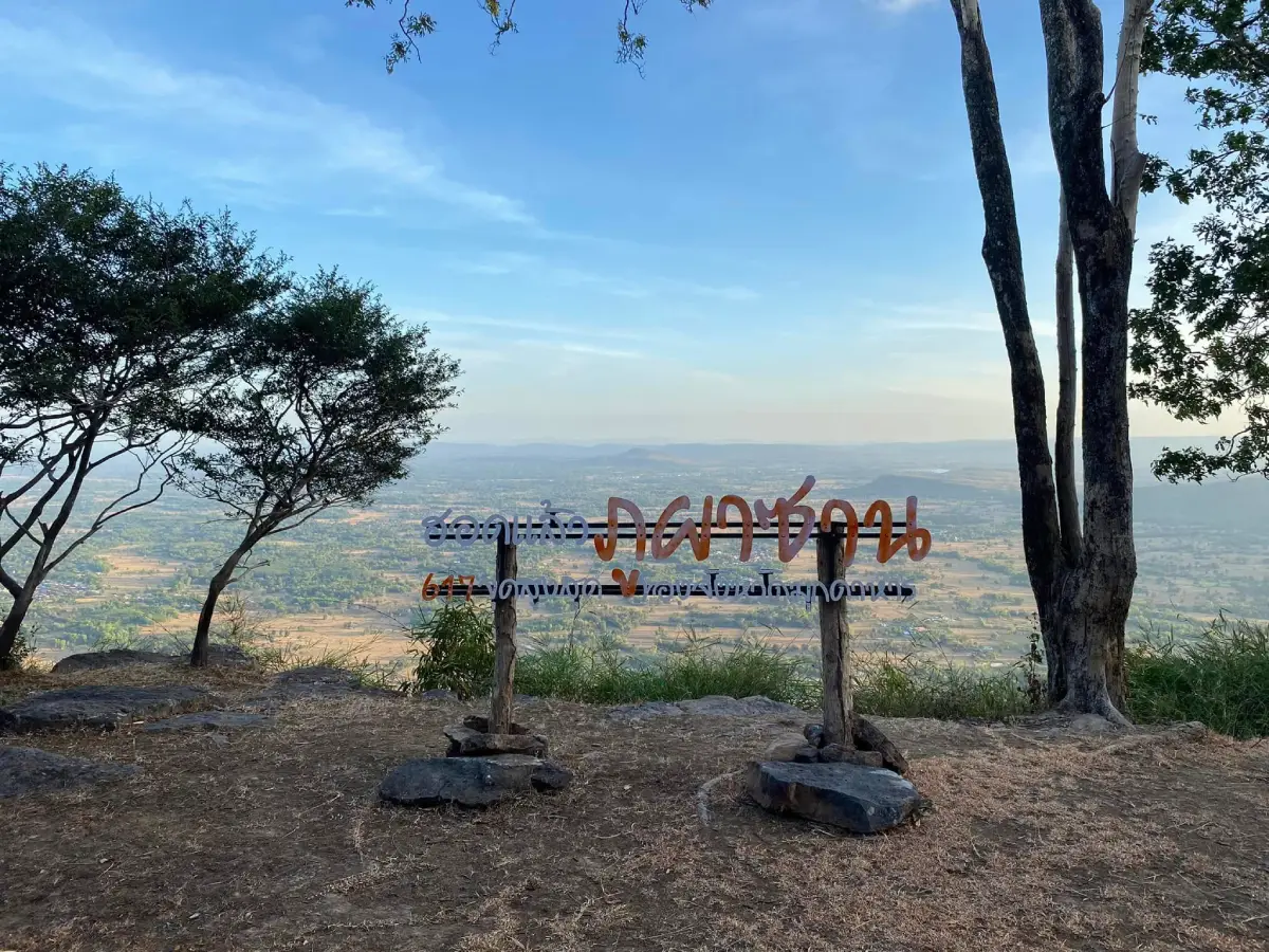
Phu Pha San in Mukdahan Province is a mountain, conservation-oriented nature attraction, and Buddhist retreat in Khamcha-i District. It is located near Ban Maet, Moo 5 and Moo 10, Ban Lao Subdistrict, in the western interior of Mukdahan. The mountain combines a natural hiking route, an elevated rock terrace, a walk-through cave, panoramic viewpoints, and the quiet religious grounds of Wat Pa Phu Pha San monastic retreat. Its best-known natural feature is a broad, relatively level rock platform covering approximately 5 rai, equivalent to about 8,000 square metres. From the upper area, visitors can look across Khamcha-i and Nong Sung districts, while sections of the Mekong River may be visible in the far distance when the air is exceptionally clear. Phu Pha San therefore offers a very different experience from Mukdahan’s better-known riverside attractions, combining mountain scenery, local spirituality, community culture, and a physically active journey within one destination.
The mountain is also known locally as Phu Mae Nang Mon. This alternative name reflects the long relationship between the landscape and the beliefs of the surrounding communities. For local residents, the mountain is not regarded simply as a scenic geological feature. It forms part of a sacred landscape associated with forests, water, community memory, and spiritual protection. From the agricultural plains of Khamcha-i, its elevated ridge acts as a prominent natural landmark. Visiting Phu Pha San is therefore not only a journey to a viewpoint. It is an opportunity to enter a place where nature, Buddhism, and local cultural beliefs remain closely connected.
Phu Pha San rises to approximately 617 metres above sea level and is widely recognised as one of the most prominent high points in Mukdahan Province. This elevation gives the upper plateau a considerably wider field of view than ordinary roadside viewpoints. From the exposed rock surface, visitors can see layers of forested hills, villages, farmland, roads, and open countryside extending in several directions. The appearance of the landscape changes markedly through the year. During the rainy season, the forest becomes a deep and vibrant green. In the cool season, mist may collect in lower valleys and depressions. During the dry months, the outlines of distant ridges and the broad structure of the terrain become easier to distinguish.
The most distinctive physical feature on the summit is the extensive rock terrace, which covers approximately 5 rai. Some sections form a broad and relatively smooth natural floor, while other areas contain shallow depressions, cracks, exposed layers, weathered blocks, and irregular surfaces. These formations are the result of long-term weathering and erosion. Rainwater, heat, wind, and repeated temperature changes gradually weakened and separated parts of the rock, creating the landscape seen today. The terrace is therefore more than a place to rest or take photographs. It is an open-air setting where visitors can observe the effects of natural geological processes directly on the surface of the mountain.
Although the exposed rock can appear dry and severe, small plants survive in cracks, thin pockets of soil, and shallow areas where moisture collects. During the rainy season, grasses, mosses, ferns, and seasonal wild plants add patches of green to the stone landscape. These plants often have shallow and delicate root systems. Walking away from established routes or repeatedly stepping on wet pockets of vegetation can cause lasting damage. Visitors should remain on existing paths, avoid collecting flowers or plants, and never move stones simply to create a photographic arrangement.
The viewpoints overlook extensive parts of Khamcha-i and Nong Sung districts. The scenery includes not only mountains but also the network of villages, fields, gardens, roads, and forest corridors below. This perspective reveals that Mukdahan is not defined solely by the Mekong River. The province also contains upland forests, sandstone landscapes, agricultural communities, and mountain systems farther inland. On exceptionally clear days, a faint section of the Mekong may be visible toward the eastern horizon. This distant view creates a geographical connection between the interior mountains and the major river that defines Mukdahan’s eastern boundary.
Early morning is one of the most atmospheric times at Phu Pha San. The first light gradually reveals several layers of ridges, while low-lying mist may gather between forests, farms, and villages. The appearance of mist depends on humidity, temperature, wind, and recent rainfall, so it cannot be guaranteed on any particular day. Even without mist, morning light provides excellent visibility and softer conditions for photography. Travelers intending to reach the viewpoint before the standard opening period should contact the caretaker or local community in advance, as some sections of the route are best approached with someone familiar with the mountain.
Late afternoon also gives the rock platform a distinctive atmosphere. Lower sunlight produces warmer tones and deeper shadows, highlighting cracks and layers that may be difficult to see under the midday sun. Visitors should nevertheless begin descending before darkness unless a properly arranged plan is in place. The route passes through natural terrain with uneven ground, slopes, and sections without permanent lighting. Watching the sunset safely requires advance planning, a reliable flashlight, a known route, sufficient time for the descent, and coordination with the caretaker.
Phu Pha San forms part of the wider forest environment associated with the Phu Si Than area. These forests act as water-catchment zones, wildlife habitat, and natural corridors between surrounding mountains. Along the route, visitors may hear birds, insects, and small forest animals, particularly in the morning or after rainfall. Noise should be kept to a minimum. Portable loudspeakers should not be used, and wildlife should never be fed. Human food can alter the behaviour of animals and bring them unnecessarily close to visitors. Pets should not be taken onto the mountain without prior approval because they may disturb wildlife and the religious routine of the monastic retreat.
A defining element of the destination is Wat Pa Phu Pha San monastic retreat. Its presence gives the mountain a dual identity as both a nature attraction and a place of Buddhist practice. The retreat has a simple forest-monastery atmosphere designed for quiet religious activity and meditation. Travelers should wear modest clothing, speak softly, and avoid entering monks’ living areas without permission. Photographs of monks, meditation activities, or private religious spaces should be taken only after consent has been given. Although visitors are welcome in appropriate areas, the primary purpose of the retreat remains Buddhist practice rather than tourism.
Phra Ajarn An Yasotharo has been identified as a monk involved in the care and religious activities of Wat Pa Phu Pha San. Group hikes, overnight stays, early access, organised ceremonies, and activities outside the standard visiting period should be arranged through the caretaker or the local community. Phu Pha San should not be treated as an unrestricted commercial campsite where tents can be placed anywhere. Sections of the mountain are forest land, religious ground, or environmentally sensitive areas. Advance contact provides current information about road conditions, meeting points, parking, weather restrictions, and any activities taking place at the retreat.
The religious area includes Buddha images and places of worship overlooking the forest. A large white Buddha image visible against the mountain landscape has become one of the recognisable visual features associated with Phu Pha San. The calm setting reflects the forest-monastery tradition of using nature as a place for mindfulness and contemplation. Visitors may pay respect and sit quietly, but they should never climb on the base of a Buddha image, place personal belongings on altars, or use sacred structures for inappropriate photographs. Respect is expressed not only through clothing but also through posture, voice, and behaviour.
The local name Phu Mae Nang Mon is connected with community reverence for Mae Nang Mon, a spiritual guardian associated with the mountain. Such beliefs are part of a broader local worldview in which mountains, forests, and water sources are understood as protected spaces with cultural and moral importance. Related ceremonies reinforce community identity and encourage respectful use of natural resources. International visitors do not need to share the belief in order to approach it respectfully. Offerings, ceremonial objects, and sacred areas should not be touched, moved, or treated as decorative props.
The walk-through cave at Phu Pha San adds another dimension to the natural route. The passage was formed through openings and fractures in the rock, creating a space through which visitors can move from one side to another. The interior is darker, cooler, and more humid than the exposed terrace. Sand, leaves, seepage, or slippery algae may be present, especially after rain. Visitors should wear shoes with good traction, carry a flashlight, and avoid entering alone. Wildlife inside cracks or cavities must not be disturbed, and no writing, candles, incense, or fire should be left within the cave.
The cave is valuable not only as a photographic feature but also as an accessible example of how fractures and weathering shape a mountain. Water gradually follows existing weaknesses in the rock and enlarges them over long periods. Travelers can observe changes in colour, rock layers, water channels, and deposits on the floor. Observation should remain non-destructive. Stones should not be struck or collected, and openings must never be enlarged. Small acts repeated by many visitors can permanently alter the original condition of the site.
For planning purposes, Phu Pha San can be understood as a sequence of connected zones. The first is the Ban Maet community and foothill coordination area, where visitors prepare, confirm conditions, and arrange transport or a local guide. The second is the natural ascent through forest, earth tracks, roots, slopes, and exposed rock. The third is the broad summit terrace and principal viewpoints. The fourth consists of the walk-through cave and surrounding rock formations. The fifth is the monastic retreat, Buddha images, and worship areas. The final zone includes rest or activity spaces that may be used only with permission. Understanding these zones helps visitors avoid accidentally entering private religious or protected areas.
The ascent is a genuine nature route rather than a level urban walkway. Hikers encounter soil, roots, irregular stones, exposed surfaces, and sloping sections that require balance and attention. Difficulty changes according to season and recent weather. After rain, soil becomes slippery, channels deepen, and algae may cover parts of the rock. In the dry season, dust, direct sunlight, and heat become more significant. Travelers without hiking experience should join someone familiar with the route, remain within sight of the group, and establish meeting points in case mobile reception becomes unreliable.
At least half a day should be allowed for a meaningful visit. The experience includes the ascent, rest periods, viewpoints, the cave, the religious area, and the descent. The time required varies according to fitness, weather, and the pace of the group. Rushing increases the risk of falls and reduces the opportunity to observe details along the route. Travelers planning to photograph the morning light, participate in religious activities, or remain on the upper mountain for an extended period should treat the excursion as a full-day journey and confirm the schedule with the caretaker.
Getting There from Mukdahan city involves following Highway 2042 toward Khamcha-i District. The destination is approximately 42 kilometres from the provincial city. After reaching the Khamcha-i area, continue toward Ban Nong Ian Thung and follow local roads to Ban Maet in Ban Lao Subdistrict. Phu Pha San is approximately 10 kilometres from the main Khamcha-i district area. Standard cars can reach the community zone, but the condition of the approach road may change with the season. A vehicle with suitable ground clearance and a driver experienced with rural roads may be preferable. Travelers should save an offline map and confirm the exact meeting point because digital maps may display separate markers for the mountain, monastic retreat, and nearby accommodation.
Travelers approaching from Nong Sung District may use local roads connecting Nong Sung and Khamcha-i, but current road conditions should be checked before departure, particularly during the rainy season. Public transport does not operate directly to the mountain trailhead. Visitors without a private vehicle should arrange a rental car or a vehicle with a local driver from Mukdahan city. Return transport should be booked in advance because regular taxis or public vehicles may not be available near the foothill.
Parking and preparation normally take place in the lower community area or at a location designated by local coordinators. Vehicles should not be driven beyond the recognised road simply because a track appears passable in dry weather. Driving outside established routes creates erosion, damages soil, and blocks natural drainage. Groups should reduce the number of vehicles by sharing transport and must not obstruct village access or emergency routes. Valuables should be carried rather than left visibly inside parked vehicles.
The most comfortable period for visiting Phu Pha San is generally from November to February. Morning and evening temperatures are cooler, skies are frequently clearer, and the physical effort of the ascent is lower than during the hot season. Visitors hoping to see mist should consider humidity, recent rainfall, and overnight temperatures. Cool, humid mornings with limited wind are more favourable, although mist remains a natural event rather than a guaranteed attraction. A light jacket is useful because the exposed summit can feel considerably cooler and windier than the village below.
The rainy season brings the richest forest colours but also the greatest safety concerns. Rain falling elsewhere on the ridge may send water through channels even when the immediate viewpoint remains dry. Thick cloud and fog can reduce visibility until paths and rock edges become difficult to identify. Hikes should be cancelled during storms, thunderstorms, or whenever local caretakers consider the route unsafe. An umbrella is unsuitable on exposed terrain in strong wind. A wearable rain jacket and waterproof protection for phones and documents are safer.
The dry and hot season offers firm trails and open skies, but heat reflected from the rock can make conditions more demanding than temperatures measured in shaded areas. Hikers should start early, carry sufficient water, wear a hat, and use sun protection. Exposed rock may become too hot for comfortable sitting during midday. Travelers with heart, blood-pressure, or respiratory conditions should evaluate their health carefully and stop immediately if they experience dizziness, nausea, unusual weakness, or a racing heartbeat.
Footwear is one of the most important pieces of equipment. Closed shoes or hiking footwear with reliable grip are strongly recommended. Flip-flops, smooth soles, and heavily worn shoes significantly increase the risk of slipping. Clothing should allow free movement, dry quickly, and remain modest enough for the monastic area. A small backpack keeps the hands free for balance. Essential items include drinking water, energy food, personal medication, a basic first-aid kit, a flashlight, a power bank, rain or wind protection, and a bag for carrying all waste back down.
Photography should never take priority over safety. A surface that appears continuous may end in a crack, slope, or exposed edge. Visitors should not walk backwards while looking at a phone screen or stand close to a drop for a dramatic photograph. Drone use requires permission and must comply with rules applying to forest and religious areas. Drone noise can disturb wildlife, monks, and meditation. Images around Buddha statues and sacred spaces should be made with appropriate posture and without climbing onto structures.
Landscape photographers may find a wide-angle lens useful for the rock terrace and layered mountains, while a medium focal length can isolate villages, farmland, or distant light. Tripods should be placed where they do not obstruct the route or create a hazard near rock edges. The character of Phu Pha San is not expressed only through its highest viewpoint. Rock textures, small plants, forest shadows, the white Buddha image, community routes, and quiet scenes around the foothill can provide a more complete visual record of the destination.
Camping or overnight activity must be arranged in advance. Phu Pha San is not a fully serviced commercial campground. Permission depends on weather, religious activities, visitor numbers, and the readiness of the site. Approved campers should bring their own equipment, minimise noise and lighting, avoid alcohol, and keep strong-smelling food away from meditation areas. Open fires are prohibited on the rock terrace and in the forest. Heat may fracture the surface, while sparks can cause a forest fire.
Food and water should be purchased in Khamcha-i or nearby communities before entering the trail. There are no full-service shops on the summit. Natural water should not be consumed without filtration and disinfection. Suitable food is easy to carry, requires minimal packaging, and creates little waste. Every item must be taken back, including fruit peel, tissue, food scraps, and biodegradable material. These items still affect wildlife and the appearance of the site.
Mobile reception may be inconsistent. A phone should therefore not be treated as the only safety system. Before starting, travelers should inform a caretaker or trusted person of the route, group size, and expected return time. Groups should remain within visual contact, with a leader at the front and an experienced member at the rear. If separated from the route, stop in a safe visible place rather than descending through a stream channel or attempting a shortcut across the forest.
Families traveling with children should evaluate each child’s stamina and ability to follow instructions. Children must not run across the rock terrace or enter the cave without close adult supervision. They should wear proper footwear, carry water, and understand that plants, rocks, and religious objects must not be collected or disturbed. Older travelers or visitors with limited mobility may find parts of the ascent unsuitable. They can still experience the foothill community or accessible religious areas after confirming current conditions with the caretaker.
Organised groups should keep numbers appropriate for the trail. Large groups are more difficult to manage in relation to timing, waste, noise, and safety. Schools, universities, companies, and clubs should provide the purpose of the visit, number of participants, vehicles, and planned activities in advance. Organisers need a first-aid plan, a system for accounting for members, and an alternative schedule if weather conditions change. A local guide contributes not only navigation but also accurate understanding of place names, community stories, etiquette, and restricted zones.
The communities around Phu Pha San lie within the Phu Tai cultural landscape of Mukdahan. Local identity can be seen through language, food, textiles, traditions, and the relationship between people, forests, and farmland. Tourism should not transform villages into decorative backdrops. Permission should be requested before photographing residents, houses, or community activities. Purchasing local food and services at fair prices helps distribute tourism income and supports the people who maintain access to the mountain.
Phu Pha San was developed as a conservation tourism destination from around 2007. Development has focused on access to nature, viewpoints, and religious spaces rather than large commercial facilities. This preserves a simple atmosphere but requires visitors to be more self-sufficient. Food, water, transport, toilet use, and communication should be planned before the ascent. Travelers should not expect summit shops, extensive visitor centres, or regular transport. Preparation allows the simplicity of the place to be appreciated as part of its character rather than regarded as a lack of service.
Facilities are concentrated around the community, lower preparation area, and monastic retreat. They are basic rather than comparable to those of a major national park. Visitors should use available toilets and organise their belongings before climbing. Monks and residents should not be expected to supply equipment that has not been arranged in advance. Donations to the retreat or conservation work should be made through an appropriate channel confirmed by the caretaker.
Current local information does not publish a fixed general admission charge. Separate expenses may apply for local transport, guiding, accommodation, meals, or activities organised for a specific group. Prices and the exact scope of service should be confirmed directly before agreement. Old travel reviews should not be treated as current price information because management arrangements and service providers may change.
Phu Pha San can be combined with other destinations in Khamcha-i District, including Khamcha-i Waterfall Park, Phu Dan Koeng, Wat Pa Wiwek Watthanaram, and Phu Tai community attractions. Travelers with additional time may continue to Nong Sung District to visit Wat Wang Kham and Ban Phu Homestay. A practical itinerary should group places located in the same direction. Attempting several mountain hikes in one day reduces safety and leaves insufficient time to understand each destination.
Most restaurants and accommodation options are located around Khamcha-i, Nam Thiang, Nong Ian, and communities along the main road. Travelers planning an early start should stay in Khamcha-i the previous night and prepare breakfast or portable food. Local accommodation consists mainly of small resorts. Guests should call to confirm availability, rates, check-in times, and the exact location. Restaurant opening days should also be reconfirmed, particularly on weekdays, public holidays, and during local events.
The most rewarding approach to Phu Pha San is to arrive with expectations that match the nature of the place. There are no rides, no fully landscaped walkway, and no commercial shopping area on the summit. What visitors receive instead is open space, wind, broad views, weathered stone, forest silence, and distance from the accelerated rhythm of urban life. Travelers interested in nature, forest Buddhism, slower journeys, and places that retain a local identity are most likely to appreciate its character.
Protecting Phu Pha San cannot be left entirely to monks, officials, or village residents. Every visitor contributes through the choice of route, control of noise, management of waste, respect for sacred spaces, and support for local services. Safe litter may be carried down when encountered. Damage, graffiti, fire, or destructive behaviour should be reported to the caretaker rather than confronted directly. Conservation becomes meaningful when visitor behaviour reduces impact instead of merely using the word as a description.
Before departure, check the weather forecast, inspect the vehicle, fill the fuel tank, download an offline map, and call 089-947-0715 to confirm road and trail conditions. A trip should be postponed after prolonged heavy rain or when the caretaker advises against the ascent. Choosing to turn back when conditions are unsafe is not a failed journey. It is an essential part of responsible mountain travel.
Phu Pha San is therefore far more than a scenic viewpoint in Mukdahan. Its 5-rai rock terrace, walk-through cave, monastic retreat, Buddha images, Phu Si Than forest environment, and views across Khamcha-i, Nong Sung, and the distant Mekong form a landscape of natural, religious, and cultural significance. Travelers who prepare carefully, respect local rules, and allow sufficient time will gain more than photographs. They will encounter a deeper and less familiar side of Mukdahan Province.
| Name | Phu Pha San, also known as Phu Mae Nang Mon |
| Location | Ban Maet, Moo 5 and Moo 10, Ban Lao Subdistrict, Khamcha-i District, Mukdahan Province |
| Address | Ban Maet, Ban Lao Subdistrict, Khamcha-i District, Mukdahan 49110, Thailand |
| Approximate Coordinates | 16.6433, 104.3667 |
| Elevation | Approximately 617 metres above sea level |
| Highlights | An approximately 5-rai rock terrace, walk-through cave, panoramic viewpoints, Wat Pa Phu Pha San monastic retreat, Buddha images, and views across Khamcha-i and Nong Sung districts |
| Tourism History | Developed as a conservation tourism destination from around 2007 |
| Alternative Name | Phu Mae Nang Mon, associated with local reverence for Mae Nang Mon of Phu Pha San |
| Distinctive Features | A prominent mountain with exposed rock, forest trails, natural formations, a cave passage, sacred areas, and extensive views |
| Natural Setting | Located within the wider forest environment associated with the Phu Si Than conservation landscape |
| Main Areas / Zones | 1. Ban Maet coordination and preparation area 2. Natural ascent trail and forest zone 3. Approximately 5-rai rock terrace and viewpoints 4. Walk-through cave and rock formations 5. Wat Pa Phu Pha San monastic retreat and Buddha images 6. Rest and activity areas available only with permission |
| Religious Caretaker | Phra Ajarn An Yasotharo, a monk involved in the care and religious activities of Wat Pa Phu Pha San |
| Travel Information | From Mukdahan city, follow Highway 2042 toward Khamcha-i, continue through the Ban Nong Ian Thung area, and use local roads to Ban Maet. The mountain is approximately 42 km from Mukdahan city and 10 km from central Khamcha-i. |
| Current Status | Open as a nature attraction and religious site. Group hikes, sunrise visits, and camping should be arranged with the caretaker. |
| Open Days | Daily |
| Opening Hours | 08.30 – 16.30 for general visits |
| Fees | No fixed general admission charge is published in current local information. Local transport, guiding, camping, or organised group services should be confirmed directly. |
| Facilities | Parking and preparation areas near the foothill, with basic facilities around the community and monastic retreat. There are no full-service shops or visitor facilities on the rock terrace. |
| Recommended Period | November to February for cooler hiking conditions, morning light, and panoramic views |
| Visitor Guidelines | Dress modestly, keep noise low, do not light fires, carry out all waste, do not mark rocks or collect plants, and do not enter monks’ private areas without permission. |
| Main Contact Number | 089-947-0715 |
| Information Page | Wat Pa Phu Pha San Monastic Retreat, Khamcha-i District, Mukdahan Province |
| Nearby Tourist Attractions | 1. Khamcha-i Waterfall Park, approximately 17 km 2. Phu Dan Koeng, approximately 24 km 3. Wat Pa Wiwek Watthanaram, approximately 26 km 4. Wat Tham Phu Noi, approximately 30 km 5. Wat Wang Kham and Ban Phu Homestay in Nong Sung District, approximately 45 km |
| Nearby Restaurants | 1. Khao Piak Restaurant, Lao Sang Tho, approximately 15 km, Tel. 063-871-7355 2. P & P Oasis Cafe, Ban Khae Subdistrict, approximately 18 km, Tel. 092-763-1277 3. Tam Pak Taek Restaurant, Nong Ian Subdistrict, approximately 20 km, Tel. 062-174-1104 4. Sit-Nee Bar Khamcha-i, Nam Thiang Subdistrict, approximately 22 km, Tel. 093-497-9499 5. Jungle Cafe Khamcha-i, Nam Thiang Subdistrict, approximately 22 km, Tel. 080-192-8925 |
| Nearby Accommodations | 1. Pha San Village, Nam Thiang Subdistrict, approximately 19 km, Tel. 089-947-0715 2. VLP Resort, Nong Ian Subdistrict, approximately 20 km, Tel. 086-238-8028 3. Sap Sathian Resort, Nam Thiang Subdistrict, approximately 22 km, Tel. 088-375-2525 4. PT Resort Khamcha-i, approximately 23 km, Tel. 093-518-8327 5. Si Rak Ruai Resort, Ban Song Subdistrict, approximately 26 km, Tel. 063-057-6415 |
Frequently Asked Questions (FAQ)
Q: Where is Phu Pha San located?
A: Phu Pha San is located near Ban Maet, Moo 5 and Moo 10, Ban Lao Subdistrict, Khamcha-i District, Mukdahan Province, approximately 10 kilometres from central Khamcha-i.
Q: What are the main highlights of Phu Pha San?
A: Its main features are an approximately 5-rai rock terrace, a walk-through cave, panoramic viewpoints, a Buddhist monastic retreat, Buddha images, and views across Khamcha-i and Nong Sung districts.
Q: What are the opening hours and is there an admission fee?
A: General visiting hours are 08.30 to 16.30 daily. Current local information does not publish a fixed general admission charge, while transport, guiding, or camping services should be confirmed directly.
Q: Is the hike to Phu Pha San difficult?
A: The route follows natural terrain with soil, roots, uneven rock, and sloping sections. Conditions change with the weather, so inexperienced hikers should travel with a local guide or someone familiar with the route.
Q: When is the best time to visit Phu Pha San?
A: November to February is generally the most comfortable period because temperatures are cooler and the views are often clearer. Mist may appear on some humid mornings.
Q: Is camping permitted at Phu Pha San?
A: Overnight stays require advance coordination and permission. Visitors cannot camp freely because the mountain contains forest areas and active religious grounds.
Q: What should visitors bring?
A: Bring closed footwear with good grip, drinking water, energy food, personal medication, a flashlight, a power bank, rain or wind protection, and a bag for carrying all waste back down.
Q: Is Phu Pha San suitable for children and older travelers?
A: Fit visitors can travel according to their ability, but children require continuous supervision. Older travelers and people with limited mobility should contact the caretaker to confirm current trail conditions and accessible areas.
 Category: ●Nature and Wildlife
 Group: ●Mountain (Doi)
Last Update : 2 MonthAgo
 Last Update : 2 MonthAgo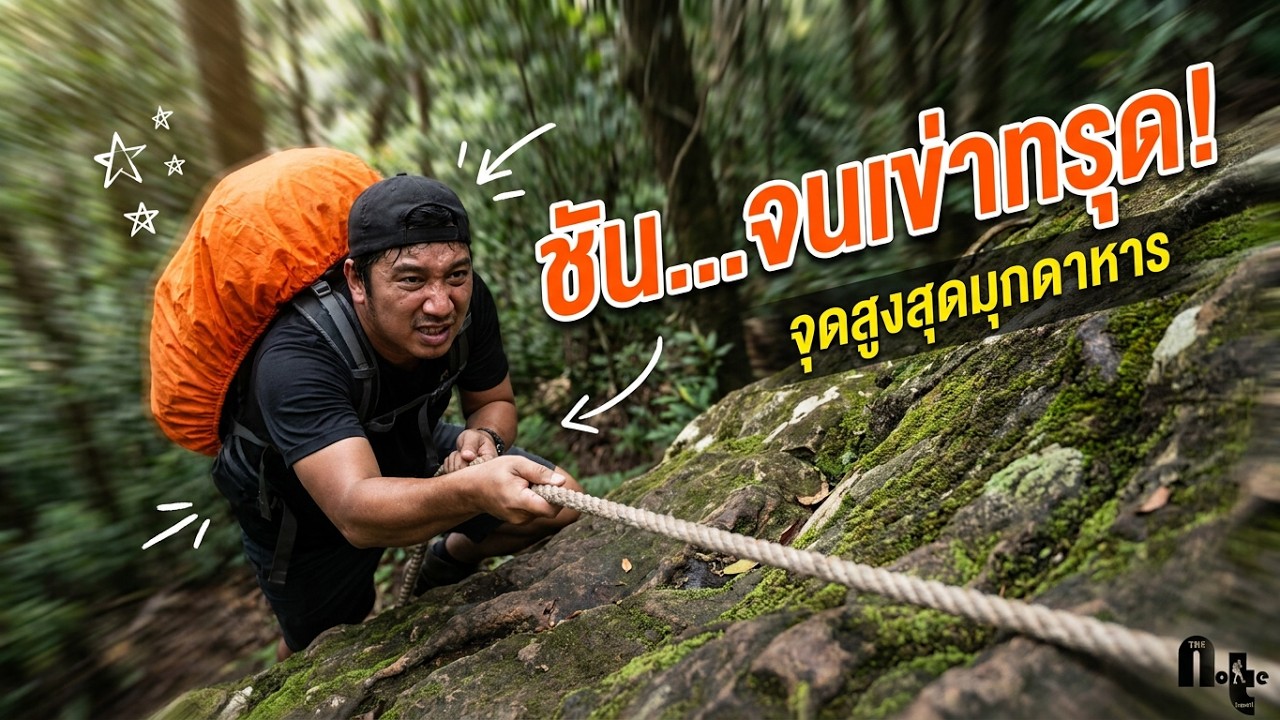
 Click to Access the Navigation Map GPS
Phu Pha San Map
Recommend

 Art, Culture and Heritage
 Historical Sites and Monuments(2)
 Landmarks and Memorials(3)
 Art, Craft Centres, Tradition(2)
 Museums(1)
 Places of Worship
 Temple(17)
 Other Sacred Sites(3)
 Suburban Living
 Village, Community(4)
 Local Market(2)
 National Parks and Marine Reserves(4)
Mountain (Doi)(5)
National Parks and Marine Reserves(4)
Mountain (Doi)(5)
 Dam, Reservoir, Lake(3)
 Waterfalls(5)
 Caves(2)
 River, Canal(2)
 Bays and Beaches(1)
 Other natural attractions(1)
 Entertainment and Agricultural
 Farms, Parks and Ecotourism(1)


