
lovethailand home >Northeastern Travel Attractions >Mukdahan Travel Attractions >Khamcha-i >Khamcha-i > Phu Dan Koeng
TL;DR: Phu Dan Koeng, Mukdahan attractions : Nature and Wildlife, Mountain (Doi).

Phu Dan Koeng
Open Days: Access is available only with prior permission and an appointment with Phu Si Than Wildlife Sanctuary. Visitors must not hike or camp independently.
Opening Hours: Office contact hours are 08:30–16:30. Trail-entry, hiking, and overnight schedules follow the plan approved by sanctuary officers.
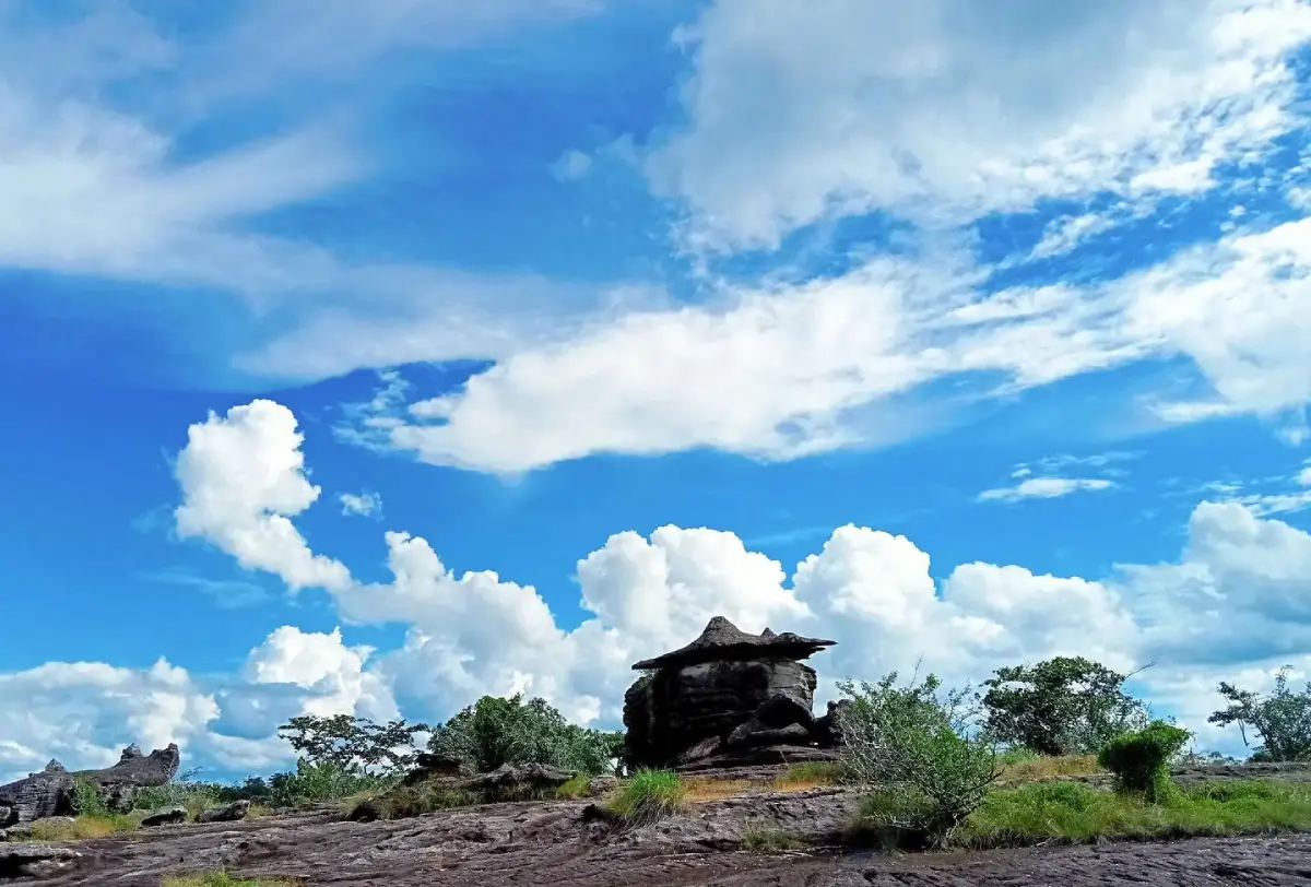
Phu Dan Koeng in Mukdahan Province, also written locally as Phu Dan Koeng, Dan Koeng, or Phu Dan Koeng Mountain, is a broad natural rock plateau near Ban Na Pung, Village No. 7, Khamcha-i Subdistrict, Khamcha-i District. It lies within the protected landscape of Phu Si Than Wildlife Sanctuary. The mountain is known for its extensive stone pavement, seasonal wildflowers, numerous cycads, weathered rock shelters known locally as hin thoep, and a seasonal waterfall flowing across the exposed rock. Its remote setting makes it suitable for controlled hiking, ecological study, landscape photography, and low-impact camping.
Phu Dan Koeng is not an unrestricted public campground or roadside viewpoint. It is located inside a wildlife sanctuary whose primary responsibilities are wildlife protection, watershed conservation, ecosystem restoration, and the prevention of illegal hunting and forest damage. Visitor access is secondary to these responsibilities. Every group must provide its intended date, group size, activity, route, and overnight plan before entering.
Trail status can change because of heavy rain, wildfire risk, wildlife movement, habitat recovery, patrol operations, and road conditions. A route that was used by a local group during a previous season may not remain open when another group arrives. Social-media photographs showing tents on the plateau are not proof that independent camping is permitted every day.
The attraction is best suited to travellers who value a simple wilderness experience rather than commercial facilities. Shops, restaurants, toilets, mains electricity, treated drinking water, permanent trail signs, and continuous mobile reception should not be expected on the mountain. Food, water, hiking equipment, medication, weather protection, and waste-management supplies must be prepared before leaving Khamcha-i town.
The Isan word “dan” describes an exposed rock pavement or broad stone surface with very shallow soil. Some sections appear almost level, while others are divided by cracks, low ridges, depressions, and drainage channels. Rainwater runs rapidly over the exposed surface but remains longer inside fractures and natural basins. These small pockets of moisture support plant communities very different from those growing in deeper forest soil.
The plateau provides an open view of the surrounding forest and sky. It can feel spacious and peaceful, particularly during the early morning and late afternoon. However, the same openness creates additional hazards. The rock absorbs direct sunlight and can become intensely hot at midday. During a thunderstorm, an exposed plateau offers little protection from lightning, strong wind, and rapidly moving rainwater.
Cracks in the rock are essential growing spaces. Sand, leaf litter, organic material, and fine soil accumulate inside them, allowing seeds to germinate and roots to develop. Mosses, grasses, ferns, small flowering plants, and young shrubs form narrow bands of vegetation across the stone. These bands must not be treated as ordinary ground or convenient walking lines.
Visitors should follow the established route and step on durable surfaces whenever officers permit. A single footprint may appear insignificant, but repeated trampling compresses the limited soil, breaks roots, and alters drainage. A route opened by one group can encourage later visitors to widen the damaged area.
Hin thoep refers to weathered rock masses, projecting slabs, or natural shelters created where different parts of the rock erode at different rates. Harder layers remain while softer material is removed by water, wind, temperature changes, and long-term weathering. The resulting formations may resemble stacked boulders, overhangs, shallow caves, or stone roofs.
Although an overhang may appear solid, it should never be climbed or used as shelter without assessment. Fractures may be hidden from below, loose fragments can fall after rain, and supporting soil may have been eroded. Narrow openings and unstable ledges are unsuitable for unsupervised exploration.
The plateau waterfall is produced by rainwater moving down the mountain, collecting in natural channels, and descending over changes in the rock level. Its appearance varies dramatically with the season. During the rainy season and early cool season, water may flow visibly across several rock steps. During a prolonged dry period, the same place may contain only shallow pools, a small stream, or dry stone.
Visitors should obtain a current report before travelling specifically to see the waterfall. Photographs taken immediately after intense rain do not represent year-round conditions. Confirming flow, trail safety, and stream crossings prevents unnecessary travel and reduces the temptation to enter a closed route.
Wet stone around a waterfall is extremely slippery, especially where algae form a thin layer beneath flowing water. Running, jumping, and wearing smooth-soled footwear are unsafe. Visitors must remain away from the edge of a drop and should never stand in the current merely to obtain a photograph.
Rain falling higher on the mountain can reach the waterfall after a delay. Water level may rise even when the immediate area appears dry. Children require continuous supervision, and no one should jump into a pool of unknown depth or swim when officers have not approved the activity.
Soap, shampoo, detergent, and washing chemicals must never be used in the waterfall or natural pools. These substances damage aquatic organisms and affect downstream water quality. When washing is permitted at a campsite, food particles should be removed first and wastewater dispersed only in the manner instructed by officers.
Cycads are among the most distinctive plants at Phu Dan Koeng. Their stiff, radiating leaves create an ancient appearance against the open rock. Cycads are slow-growing plants, and larger individuals may have taken many years to reach their present size. Cutting leaves, removing seeds, digging up a plant, or damaging its base can cause long-term loss.
The ground around a cycad may look durable because it is surrounded by stone, but roots often occupy narrow fractures containing only a limited amount of soil. Repeated footsteps, bags placed against the trunk, and tents positioned nearby can compress or dislodge that soil. Photographers should use distance and suitable lenses rather than standing within the plant’s root zone.
Seasonal wildflowers are another defining feature. They do not bloom continuously throughout the year. Rain fills cracks and shallow soil during the monsoon. As rainfall begins to decrease, many small plants complete a rapid cycle of growth, flowering, seed production, and dormancy before the plateau dries again.
White, yellow, pink, purple, and blue flowers may appear among grasses, mosses, and cycad leaves. Their beauty depends on small details rather than the scale of a cultivated flower field. Many plants are only a few centimetres high and can be overlooked when visitors walk towards a visible cluster.
Leaving the route for a low-angle photograph may destroy plants hidden behind the subject. Camera bags, tripods, picnic mats, and jackets must not be placed on vegetation. A close-focusing lens or optical zoom is the appropriate way to record small flowers without trampling their habitat.
Flowers must not be picked. Removing a bloom before it produces seed reduces the next generation of plants. Plateau species already survive under strong sunlight, shallow soil, intense heat, and seasonal drought. Recovery from visitor damage can take several years.
The forest surrounding the plateau functions as an ecological buffer. Deeper soil, shade, and leaf litter retain moisture and support taller vegetation. Birds, reptiles, insects, and small mammals move between the forest edge, the rock surface, and water sources according to time of day and season.
Creating a shortcut through edge vegetation damages both habitats. It removes shelter, increases erosion, and produces additional human routes through an area used by wildlife. Visitors should never cut branches or clear plants merely to make the route wider.
Phu Dan Koeng forms part of Phu Si Than Wildlife Sanctuary, a large protected forest extending across Mukdahan and Kalasin provinces. The sanctuary contains dry evergreen forest, dry dipterocarp woodland, mixed deciduous forest, grassland, mountain streams, and rocky plateaus. Wildlife may use the same routes, pools, and open spaces that visitors intend to cross.
Tracks, droppings, feeding marks, disturbed soil, hair on vegetation, and calls from the forest provide evidence of animal activity. These signs should be observed without being followed. If an animal appears on the trail, the group should stop, remain quiet, and allow it to move away.
Visitors must never chase an animal for a photograph or block its escape route. Female animals with young and wild boar may react defensively when approached. A telephoto lens and respectful distance are safer for both the visitor and the animal.
Feeding wildlife is prohibited. Rice, fruit, snacks, and cooked food alter natural behaviour. Animals that associate camps with food may return, damage tents, steal supplies, or become aggressive. Food must remain inside sealed containers and every scrap must be removed from the sanctuary.
Many animals become active after sunset. Campers should not walk beyond the designated area alone, search the forest with high-powered lights, or play music. A low torch directed at the ground provides sufficient visibility while reducing disturbance.
The Dan Koeng area also has scientific geological significance. Thailand’s fossil-site inventory records crocodile teeth and turtle-shell fragments from the Dan Koeng vertebrate fossil locality. These remains provide evidence of past animals and environments that differed from the present-day mountain plateau.
A fossil locality is not a place for recreational digging. Hammers, chisels, and excavation tools must not be used. A fossil’s position within the rock can be as scientifically important as the specimen itself. Removing it destroys contextual information and may violate Thai fossil-protection law.
Anyone who notices an object resembling bone, tooth, or shell should leave it in place, photograph it without touching, record a general location, and inform sanctuary officers or the Department of Mineral Resources. Exact coordinates should not be posted publicly, as this could encourage illegal collecting.
A Forest Department record also lists a religious forest site called Silathip (Dan Koeng) at Ban Na Pung within Phu Si Than Wildlife Sanctuary. The name reflects the relationship between the rock landscape, seclusion, and religious practice. It does not guarantee that monks are permanently resident or that the site operates as a conventional tourist temple.
If visitors encounter a shelter, Buddha image, shrine, monastic hut, or worship area, they should behave respectfully. Religious objects must not be moved, and an altar must not be used for bags or cooking equipment. Permission should be requested before photographing people in retreat or using any facility.
Camping matches the wilderness character of Phu Dan Koeng, but the broad rock surface is not a free-choice campground. Officers must consider wildlife routes, drainage, fragile vegetation, fossil areas, exposed wind, hazardous trees, and religious use before assigning a campsite.
Tents may be erected only at an approved location. Campers should inspect slope, drainage lines, rock cracks, and overhead branches. A tent must not be placed beside a cliff, directly below dead branches, close to the waterfall, or inside a natural water channel.
Rock surfaces may not accept ordinary tent pegs. Campers need a securing method that does not drill, hammer, or damage stone and plants. If the site cannot safely support the equipment, the correct response is to move to another approved area rather than modify the plateau.
Drainage trenches must not be dug and rocks must not be rearranged into walls. These actions redirect water and disturb the small plant communities growing in cracks. The natural surface should remain in the same condition after the group leaves.
Fire regulations must be followed strictly. Dry grass and fallen leaves around the plateau can ignite rapidly. Open fires are prohibited unless a designated arrangement has been specifically approved. Cooking should use the authorised system, with water available and all heat fully extinguished before departure.
Waste must never be burned. Plastic and coated packaging produce toxic smoke, while food odours attract animals. Groups should reduce rubbish before travelling by using reusable water bottles, food boxes, cups, and utensils.
Permanent toilets may be unavailable near the plateau. Visitors must ask officers which waste system applies to their activity. Wet wipes, sanitary products, tissues containing plastic fibres, and other synthetic material must be packed out rather than buried.
Drinking water should be carried from Khamcha-i in sufficient quantity. The waterfall must not be treated as automatically safe drinking water. Clear water can contain microorganisms and contamination from wildlife. Any plan to use natural water requires proper filtration and disinfection.
Essential equipment includes broken-in hiking shoes with deep tread, long trousers, quick-drying clothing, a hat, rain protection, a headlamp, spare socks, personal medication, a first-aid kit, a whistle, a fully charged telephone, and a power bank. Equipment should be packed inside waterproof bags.
Sandals and smooth-soled shoes are unsuitable for wet rock, slopes, and roots. Camp footwear can be carried separately, but walking barefoot at night risks cuts, insect stings, and encounters with small animals.
A hiking group should appoint a leader and a final person. The pace must reflect the slowest member. No one should overtake the authorised guide or leave the route to take photographs without informing the group.
Rest stops should be taken where the group remains visible and the trail is not blocked. Open rock can contain several similar lines and few obvious landmarks, making a temporarily separated visitor difficult to locate.
Every participant should know the meeting point, expected return time, and emergency procedure. A lost visitor should stop in a safe place and use a whistle or telephone rather than following an animal path or drainage channel into unfamiliar terrain.
Visitors with heart disease, high blood pressure, respiratory illness, knee or ankle problems, severe allergies, or limited mobility should assess the route before joining. Personal medication must remain with the owner rather than in a vehicle or shared bag.
The rainy season brings green forest, active streams, and growing wildflowers, but also slippery rock, leeches, insects, soft soil, and rapidly changing water levels. Access after heavy rain must be confirmed with officers. A scheduled holiday does not justify entering an unsafe route.
The late rainy season and early cool season are generally the most attractive periods for wildflowers, cycads, and waterfall flow. Flowering time changes with annual rainfall, so current local information is more useful than relying on the same calendar dates every year.
The cool season is comfortable for hiking and camping, but wind on the open plateau may be considerably stronger than in Ban Na Pung. Tents need suitable wind resistance, and campers should carry a light insulating layer, sleeping equipment, and protection from dew.
Midday can still be hot even during the cool season. The exposed surface absorbs sunlight, and shade is limited. Water and sun protection remain necessary throughout the year.
The hot season brings dehydration and wildfire risk. Hiking should begin early, avoiding the hottest period of the day. Headache, nausea, confusion, unsteady walking, and extreme weakness can indicate heat illness and require immediate cooling and evacuation assessment.
Smoke, burning smells, ash, or a visible fire line must be reported at once. Visitors should leave according to officer instructions and must not approach a wildfire for photography. Smoking and any device capable of producing sparks are inappropriate beside dry vegetation.
Thunderstorms are a major hazard on an exposed plateau. At the first sound of thunder, visitors should leave high points, cliff edges, and isolated trees under guide direction. Reaching a planned viewpoint is never more important than responding to changing weather.
Wildflower photography should use close-focusing lenses or zoom without entering vegetation. Rocks, leaves, and cycad fronds must not be moved to improve a composition. Waterfall photographs should be taken from stable ground rather than from the current.
Night photography must remain within the approved camping zone. Tripods should not obstruct walking lines, and bright lights must not be directed towards the forest. The dark environment belongs to nocturnal animals as well as photographers.
Flying a drone inside a wildlife sanctuary requires authorisation. Noise and shadow can disturb birds and mammals. Mountain wind can change quickly, increasing crash risk and leaving electronic debris in an inaccessible area.
Families with young children and older travellers should ask about trail difficulty before booking. The plateau has no railings, the surface can be uneven, and the waterfall is slippery. Children must remain within immediate adult control.
Mobile reception may be unreliable. Groups should save emergency numbers, meeting instructions, and an offline map. A backup plan is required for vehicle failure, illness, severe rain, or a delayed return.
Getting There begins in Khamcha-i District, Mukdahan Province. Travellers continue to Ban Na Pung, Village No. 7, Khamcha-i Subdistrict. The actual parking and trail meeting point must be obtained from sanctuary officers because Phu Dan Koeng has no conventional public entrance gate.
From Mukdahan city, Highway 12 leads towards Khamcha-i. Local roads then continue to Ban Na Pung. A private or rental vehicle is the most practical option because scheduled public transport does not reach the hiking trailhead.
Village roads may be passable by an ordinary car in normal weather, while later sections can become muddy or deeply eroded after rain. Officers may require a pickup truck or four-wheel-drive vehicle. Online navigation alone should not be used to drive into a protected forest road.
Fuel, food, drinking water, ice, medication, and supplies should be purchased in Khamcha-i town. Small village shops should not be expected to provide specialist camping equipment or sufficient supplies for a large group.
A one-day trip should begin with an early meeting and equipment check. The group can hike to the plateau, observe cycads, seasonal flowers, hin thoep formations, and the waterfall on the authorised route, then begin returning with at least 1–2 hours of daylight remaining.
A two-day, one-night programme allows visitors to experience evening, night, and morning conditions. Camp should be reached early enough to inspect the site and prepare before dark. Movement beyond the campsite should stop at night unless specifically led by officers.
Camping should never be planned until the site, capacity, water arrangement, and fire rules have been confirmed. Officers may close the plateau because of storms, wildfire, plant recovery, fossil protection, or wildlife use.
Nearby attractions around Khamcha-i include Huai Khan Tae Yai Reservoir, the Mae Chi Kaew Sianglam Nunnery, Wat Tham Luang Pu Sao, Phra That Phothiyan at Wat Pa Suphattaram, and Wat Pa Wiwek Watthanaram. These are best visited before or after the hiking day rather than added to a full wilderness programme.
Restaurants, fuel stations, convenience shops, and most accommodation are concentrated in central Khamcha-i. The town is the practical base for buying supplies and staying overnight before an early departure.
Distances in the summary table use central Khamcha-i as the service reference point because the forest meeting location is not maintained as a permanent public tourist coordinate. Travellers must add the distance to Ban Na Pung and the authorised trailhead supplied for their visit.
Phu Si Than Wildlife Sanctuary is currently managed by Mr Khamkrit Samphetcharoen. The sanctuary office can be contacted at 043-840422, while 099-0197307 is also used for visitor and activity coordination. Calls should be made during office hours several days before travel.
Khamcha-i Subdistrict Administrative Organization can assist with local road and community information at 042-642143–4. Permission for hiking and overnight use inside the sanctuary must still come from the responsible protected-area officers.
No standard Phu Dan Koeng admission ticket has been publicly announced. Costs may apply for guiding, vehicles, camping, or authorised programmes. The total amount, payment procedure, and included services must be confirmed directly rather than using a national park fee schedule.
As of 17 July 2026, no permanent closure announcement has been identified. Phu Si Than Wildlife Sanctuary continues conservation and patrol operations. Phu Dan Koeng remains a permission-based destination whose trail may close temporarily because of rain, fire, patrol work, ecological restoration, or scientific survey.
Conservation travel requires accepting these limitations. When officers report that flowers are recovering, wildlife is using the plateau, water is dangerous, or wildfire risk is high, visitors must postpone or change their route. Continuous public access is not the primary objective of a wildlife sanctuary.
Every visitor can protect Phu Dan Koeng by remaining on the route, picking no flowers, removing no cycads, collecting no fossils, carving no rock, feeding no animals, lighting no unauthorised fire, flying no unauthorised drone, and carrying out all rubbish.
The value of Phu Dan Koeng comes from the interaction of many natural elements. Rock records the long weathering of the mountain. Fractures support wildflowers. Cycads create an ancient-looking plant landscape. Seasonal rain produces a waterfall. Surrounding forest shelters wildlife, while the rock layers preserve evidence of animals from the distant past.
Travellers who prepare carefully, coordinate with the caretakers, and minimise their impact will experience the mountain at its best. Wind across the plateau, the scent of forest after rain, small flowers, cycads, and water moving over stone remain powerful precisely because Phu Dan Koeng has not been transformed into a crowded commercial attraction.
| Name | Phu Dan Koeng, Mukdahan |
| Thai Name | ภูดานเกิ้ง จังหวัดมุกดาหาร |
| Alternative Names | Phu Dan Koeng, Dan Koeng, and Darn Koeng |
| Attraction Type | Mountain, natural rock plateau, hiking route, seasonal waterfall, and controlled conservation campsite |
| Location | Ban Na Pung, Village No. 7, Khamcha-i Subdistrict, Khamcha-i District, Mukdahan Province, Thailand |
| Protected Area | Phu Si Than Wildlife Sanctuary |
| Highlights | Broad rock pavement, seasonal wildflowers, numerous cycads, hin thoep formations, a waterfall on the plateau, hiking, and low-impact camping |
| Landscape | Open mountain plateau with cracks, natural pools, drainage channels, rock shelters, hin thoep formations, and surrounding forest |
| Notable Plants | Cycads, seasonal wildflowers, grasses, shrubs, mosses, ferns, and small plants growing in rock fractures |
| Water Feature | A seasonal waterfall and shallow streams whose flow changes with rainfall |
| Geological Importance | Thailand’s fossil inventory records crocodile teeth and turtle-shell fragments at the Dan Koeng vertebrate fossil locality |
| Religious Forest Site | A Forest Department record lists Silathip (Dan Koeng) at Ban Na Pung within Phu Si Than Wildlife Sanctuary |
| Main Areas / Zones | 1. Ban Na Pung Coordination Point 2. Forest Approach Trail 3. Main Rock Plateau 4. Cycad Areas 5. Seasonal Wildflower Areas 6. Hin Thoep Formations 7. Waterfall And Rock Drainage Channels 8. Officer-Approved Campsite 9. Silathip (Dan Koeng) Religious Forest Area 10. Protected Fossil Locality |
| Open Days | Access is available by prior permission and appointment. The trail is not guaranteed to open every day. |
| Opening Hours | Office contact hours are 08:30–16:30. Entry and exit times follow the approved itinerary. |
| Entry Requirements | Visitors must provide the date, group size, activity, route, and overnight plan to Phu Si Than Wildlife Sanctuary before travelling. |
| Admission And Service Fees | No standard Phu Dan Koeng admission ticket has been announced. Guiding, vehicle, and camping costs must be confirmed directly. |
| Camping | Permitted only at an approved site and date. Independent camping is prohibited near wildflowers, cycads, drainage channels, cliffs, and fossil areas. |
| Facilities | Very limited. Visitors must carry water, food, tents, hiking equipment, lighting, medication, and waste-management supplies. |
| Activities | Hiking, nature study, wildflower and cycad observation, rock-landform study, waterfall viewing, photography, stargazing, and controlled camping |
| Best Season | Late rainy season through the cool season for wildflowers, waterfall flow, and hiking, subject to weather and trail confirmation |
| Recommended Duration | A full day for a return hike or 2 days / 1 night for an authorised camping programme |
| Travel Information | Take Highway 12 from Mukdahan city to Khamcha-i and continue to Ban Na Pung. Parking and the trail meeting point must be obtained from officers. |
| Suitable Vehicles | Private or rental vehicle. Dirt-road sections may require a pickup truck or four-wheel drive after rain. |
| Caretaker | Mr Khamkrit Samphetcharoen, Head of Phu Si Than Wildlife Sanctuary |
| Main Contact Numbers | 043-840422, 099-0197307 |
| Local Authority | Khamcha-i Subdistrict Administrative Organization, Tel. 042-642143–4 |
| Current Status | No permanent closure announcement was identified as of 17 July 2026. Access remains permission-based and may close temporarily. |
| Visitor Guidelines | Pick no flowers, remove no cycads or fossils, light no unauthorised fires, feed no wildlife, fly no unauthorised drones, and carry out all rubbish. |
| Nearby Tourist Attractions | Approximate distances from central Khamcha-i, the practical service point before continuing to Ban Na Pung 1. Huai Khan Tae Yai Reservoir, 8 km 2. Mae Chi Kaew Sianglam Nunnery, 9 km 3. Wat Tham Luang Pu Sao, 11 km 4. Phra That Phothiyan At Wat Pa Suphattaram, 12 km 5. Phu Pha San Monastic Retreat, 16 km 6. Wat Pa Wiwek Watthanaram / Wat Luang Pu Cham, 20 km |
| Nearby Restaurants | Approximate distances from central Khamcha-i; additional travel to Ban Na Pung is required 1. DNN Factory, 3 km, Tel. 096-9070793 2. Phayhard Cafe And Son, 5 km 3. Lan Khun Ta Mukda Cafe, 6 km, Tel. 061-4478533 4. Ban Rao Cafe And Restaurant, 6 km 5. Nong Khian Homestay Restaurant, 10 km, Tel. 096-8287747, 089-8121378 |
| Nearby Accommodations | Approximate distances from central Khamcha-i; additional travel to Ban Na Pung is required 1. PT Resort Khamcha-i, 5 km, Tel. 093-5188327, 081-7298459 2. Mayu Resort, 6 km, Tel. 093-2512699, 061-1342924 3. Suksomboon Resort, 7 km, Tel. 098-6261396 4. Ban Yai Nan Resort, 8 km, Tel. 084-4287235, 090-5879966 5. Chonlathan Resort Khamcha-i, 10 km, Tel. 083-2843088, 087-8557564 |
Frequently Asked Questions (FAQ)
Q: Where is Phu Dan Koeng located?
A: Phu Dan Koeng is near Ban Na Pung, Village No. 7, Khamcha-i Subdistrict, Khamcha-i District, Mukdahan, within Phu Si Than Wildlife Sanctuary.
Q: Is Phu Dan Koeng open every day?
A: No fixed daily public access is guaranteed. Entry requires prior permission, and the trail may close because of rain, wildfire, patrol operations, wildlife activity, or habitat restoration.
Q: Is there an entrance fee?
A: No standard Phu Dan Koeng admission ticket has been announced. Costs for guides, transport, and camping must be confirmed for the authorised programme.
Q: Can visitors camp on the rock plateau?
A: Camping is allowed only at a site and time approved by sanctuary officers. Visitors must not select a campsite near wildflowers, cycads, drainage channels, cliffs, or fossil areas.
Q: When is the best time for wildflowers and the waterfall?
A: The late rainy season and early cool season generally provide the best conditions, although flowering and water flow depend on annual rainfall and current trail safety.
Q: Have fossils been found at Dan Koeng?
A: Thailand’s fossil inventory records crocodile teeth and turtle-shell fragments at the Dan Koeng locality. Fossils must never be excavated, collected, or moved.
Q: What equipment is required for the hike?
A: Visitors should carry hiking shoes, water, food, rain protection, a headlamp, personal medication, a first-aid kit, a power bank, and bags for carrying out all rubbish, together with any equipment specified by officers.
Q: How can visitors arrange access?
A: Contact Phu Si Than Wildlife Sanctuary at 043-840422 or 099-0197307 during office hours to confirm the route, permission, guide, camping arrangements, and current conditions.
 Category: ●Nature and Wildlife
 Group: ●Mountain (Doi)
Last Update : 2 MonthAgo
 Last Update : 2 MonthAgo
 Click to Access the Navigation Map GPS
 Art, Culture and Heritage
 Historical Sites and Monuments(2)
 Landmarks and Memorials(3)
 Art, Craft Centres, Tradition(2)
 Museums(1)
 Places of Worship
 Temple(17)
 Other Sacred Sites(3)
 Suburban Living
 Village, Community(4)
 Local Market(2)
 National Parks and Marine Reserves(4)
Mountain (Doi)(5)
National Parks and Marine Reserves(4)
Mountain (Doi)(5)
 Dam, Reservoir, Lake(3)
 Waterfalls(5)
 Caves(2)
 River, Canal(2)
 Bays and Beaches(1)
 Other natural attractions(1)
 Entertainment and Agricultural
 Farms, Parks and Ecotourism(1)


