
lovethailand home >Northeastern Travel Attractions >Mukdahan Travel Attractions >Khamcha-i >Khamcha-i > Saksit Waterfall
TL;DR: Saksit Waterfall, Mukdahan attractions : Nature and Wildlife, Waterfalls.

Saksit Waterfall
Open Days: Temporarily closed until further notice
Opening Hours: No visiting sessions are available while the closure remains in force
Latest Status: Phu Si Than Wildlife Sanctuary closed its forest areas for ecological restoration and wildlife protection as of 18 July 2026. Entry without official permission is prohibited
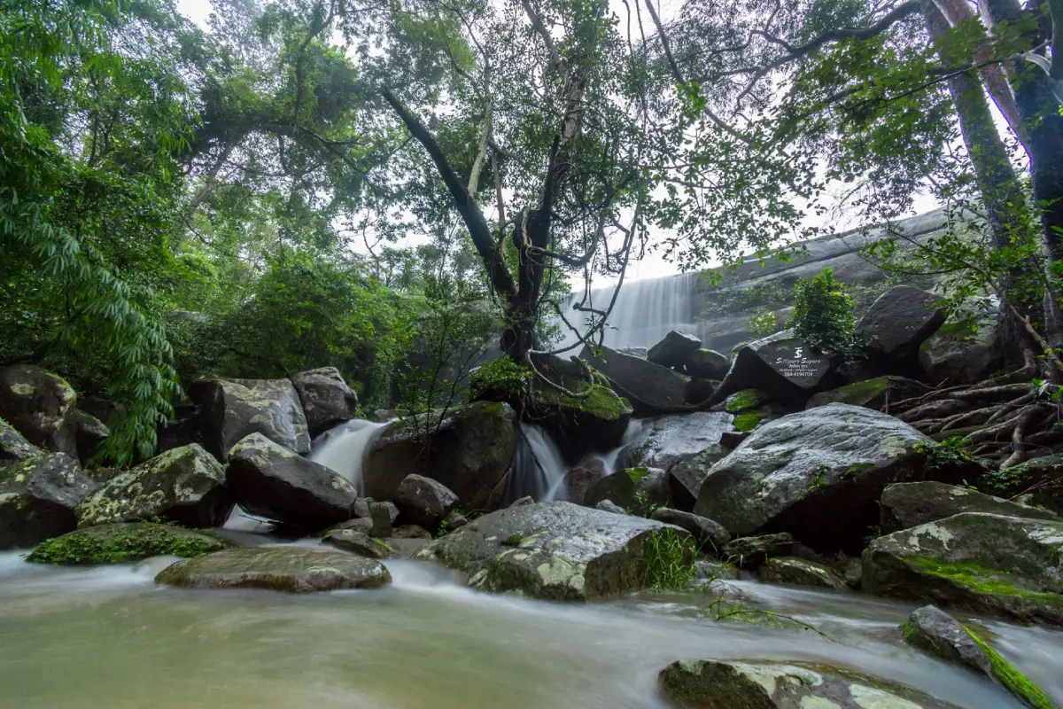
Saksit Waterfall is a natural waterfall of exceptional ecological, historical, cultural and ceremonial importance in Mukdahan Province. It is situated near Ban Kaeng Chang Niam, Moo 10, Kham Cha-i Subdistrict, Kham Cha-i District, inside Phu Si Than Wildlife Sanctuary. The waterfall descends approximately 20 metres from a rocky cliff surrounded by highly intact forest. The dry evergreen forest immediately around the waterfall is regarded as one of the most biologically complete examples of this forest type in Mukdahan. The site is therefore much more than a scenic cascade. It is an important headwater area supporting local communities, agriculture and several streams across the province.
The current status of Saksit Waterfall differs from that of an ordinary tourist attraction. In July 2026, Phu Si Than Wildlife Sanctuary announced an indefinite closure of its forest areas after rubbish and inappropriate visitor activity were found to be affecting natural resources and wildlife. The measure is a temporary conservation closure rather than a permanent abandonment of the waterfall. Travelers must wait for a formal reopening announcement and should not attempt to reach the waterfall independently, even when they have previously used the route or can see an access track in an online navigation application.
The waterfall was traditionally known as Kaeng Chang Niam Waterfall, after the nearby community of Ban Kaeng Chang Niam. Some local records also refer to the site by the earlier name Tad Ton Phu Si Than Waterfall, describing water descending from a rock terrace in the Phu Si Than landscape. A systematic survey of the water source was conducted in 1987, revealing its importance as a headwater and its association with community beliefs. Mukdahan Province officially changed the name from Kaeng Chang Niam Waterfall to “Saksit Waterfall,” meaning Sacred Waterfall, on 4 November 1987.
The word “sacred” is not merely a modern tourism label. It reflects the official use of water from this source in important provincial ceremonies. The waterfall is recognized as a sacred water source of Mukdahan and has supplied water for the preparation of consecrated water on major auspicious occasions. Its identity therefore combines natural significance, spiritual value and the long relationship between local communities and the waters flowing from the Phu Si Than forest.
In 2024, the Governor of Mukdahan and participating officials conducted a formal water-collecting ceremony at Saksit Waterfall. The water was used in the preparation of sacred Buddhist water for the auspicious celebration of His Majesty the King’s 6th-cycle birthday anniversary on 28 July 2024. The procedure followed an established ceremonial sequence, including preparation of the site, a rite requesting permission from the sacred place, collection and procession of the water, and its consecration at the ordination hall of Wat Si Mongkhon Tai, a royal temple in Mukdahan city.
The water source also has substantial hydrological importance. Phu Si Than forms the headwaters of several streams, including Huai Bang Sai, Huai Bang I, Huai Muk and Huai Ta Puea. These waterways descend from the mountains, pass through forest, farmland and settlements, and eventually connect with larger drainage systems. Protecting the forest around the waterfall directly affects water volume, water quality, sediment control and the ability of the landscape to retain moisture between the rainy and dry seasons.
During the rainy season, the forest canopy, leaf litter and soil absorb part of the rainfall before releasing it gradually into channels and streams. This process slows runoff, reduces erosion and helps the water flow for longer than it would in a deforested landscape. When headwater forest is cleared, rainfall can descend rapidly, producing flash floods and transporting large quantities of sediment. Streams then lose moisture more quickly after the rains end. Closing the area for ecological restoration is therefore directly connected with protecting long-term water security.
The waterfall drops from a rocky cliff approximately 20 metres high. When water volume is strong, a white curtain descends against the dark cliff and green forest. During periods of lower flow, the waterfall may divide into several narrow streams following channels in the rock. Its appearance changes according to the season, recent rainfall and moisture in the upper catchment. Photographs taken during peak flow should not be used to predict conditions in every month of the year.
The base of the waterfall contains boulders, rock terraces and natural pools shaped by continuous erosion. Some channels are deeper than they appear, and underwater surfaces are uneven. Clear water may reveal parts of the rock floor while concealing sudden drops or submerged obstacles. The height of the cliff, wet stone and naturally fallen branches make controlled access essential. Entering without rangers exposes visitors to falls, disorientation and delays in receiving emergency assistance.
The forest is one of the features that distinguishes Saksit Waterfall from smaller roadside cascades. Moist areas near the stream support a notable dry evergreen community with relatively continuous canopy, trees, climbing plants, undergrowth, ferns and mosses. Elsewhere in Phu Si Than Wildlife Sanctuary, the landscape includes mixed deciduous forest, dry dipterocarp forest, grassland and regenerating woodland. This variation in vegetation makes the sanctuary important for regional biodiversity conservation.
Dry evergreen forest contains several layers of trees, creating shade and maintaining a cooler forest floor. Accumulated leaves form organic soil and retain moisture, while decaying logs, roots and rock cavities provide habitat for insects, amphibians, reptiles and many smaller organisms. Leaving the trail or moving a fallen log for a photograph can therefore destroy habitat that is not immediately visible to the visitor.
Phu Si Than Wildlife Sanctuary was formally declared on 8 November 2000. It covers parts of Dong Luang, Kham Cha-i and Nong Sung districts in Mukdahan Province, together with sections of Khao Wong and Kuchinarai districts in Kalasin Province. Its total area is approximately 156,250 rai. Most of the sanctuary consists of mountain terrain in the lower Phu Phan Range, generally between about 200 and 592 metres above sea level, forming a major forest and watershed connection between the two provinces.
The mixture of mountains, valleys and lower terrain creates channels, cliffs, rock platforms and small wet habitats. Sun-exposed slopes support relatively open vegetation, while shaded valleys retain moisture and denser forest. Differences in slope direction, elevation and water availability influence the plants and animals found in each locality. Saksit Waterfall lies within one of the more humid forest environments and is therefore valuable for ecological observation and research.
The sanctuary has a tropical monsoon climate with hot, rainy and cool seasons. Official ecological information records average annual rainfall of approximately 1,364.71 millimetres, with August normally receiving the greatest rainfall. Waterfall flow is closely related to these seasonal rains. Late rainy season offers the greatest chance of seeing a strong cascade, but it is also the period of highest risk from intense rain, flash flooding, slippery paths and falling branches.
From approximately November to February, cooler weather creates pleasant morning conditions, although the waterfall gradually loses volume as rainfall ends. March to May is hotter and drier, with greater risk of wildfire and smoke. Protected areas may close routes during this period to prevent fire. Even after a fire emergency has passed, officials may keep the forest closed while they assess ecosystem recovery, wildlife disturbance and visitor safety.
Phu Si Than Wildlife Sanctuary supports diverse mammals, birds, reptiles and amphibians. Surveys have recorded significant wildlife groups, including slow lorises, macaques, pangolins, bears, wild boar, muntjac and smaller forest species. Actual sightings depend on season, time and the level of disturbance. Visitors should not enter the sanctuary with the intention of closely pursuing animals, as this may force wildlife away from feeding, resting and breeding areas.
The stream and pools around the waterfall are particularly important to wildlife during the later dry season. Animals may come to drink, feed or move along the riparian corridor. Large groups, loud noise, food smells and discarded rubbish can prevent them from using the water. Food waste may also teach wildlife to approach people, increasing the risk of conflict and disease. These impacts explain why protected areas must strictly control visitor numbers, access routes, times and activities.
The July 2026 closure was intended to give natural resources and wildlife an opportunity to recover after rubbish and inappropriate forest use were reported. Plastic, rope, food containers and other materials can trap animals, enter streams or fragment into smaller pollutants. Removing rubbish from steep forest terrain is considerably more difficult than cleaning an urban park. Preventing waste from entering the forest is therefore more effective than attempting to collect it later.
Entering during the closure may lead to legal action as well as physical danger. A wildlife sanctuary is not a public park with unrestricted admission. Access is governed by conservation law, official regulations and ranger permission. Photographs or social-media posts produced before the closure do not prove that entry is currently permitted. Travelers must rely on the most recent announcement issued by Phu Si Than Wildlife Sanctuary and the Department of National Parks, Wildlife and Plant Conservation.
When the sanctuary eventually reopens, every proposed journey should begin with direct contact with officials. Visitors must confirm whether the waterfall is included in the reopened area, whether written permission or a visitor list is required, whether daily capacity has been established, whether a ranger or community guide must accompany the group and how far private vehicles are allowed to proceed. Permission to enter the sanctuary never means that every route or activity is automatically available.
The general approach begins in Kham Cha-i District. Travelers use Highway 12 on the Mukdahan–Kuchinarai route for approximately 12 kilometres before turning onto a local road toward Ban Kaeng Chang Niam, Moo 10. The village is approximately 20 kilometres from central Kham Cha-i. Public roads to the community are relatively accessible by private vehicle, but the continuation from the village into the forest and waterfall area remains under ranger control and changes according to season and ground conditions.
From Mukdahan city, follow Highway 12 toward Kham Cha-i and Kalasin. The distance to central Kham Cha-i is approximately 35 kilometres. The journey then continues toward Ban Kaeng Chang Niam. Driving from the city to the community normally takes around one hour, depending on the starting point and traffic. The time required to reach the waterfall cannot be estimated from road travel alone because reopening conditions may involve registration, waiting for rangers, changing vehicles or completing part of the journey on foot.
A private car is the most practical form of transport to Ban Kaeng Chang Niam because scheduled public transport does not reach the waterfall approach. The vehicle should have sufficient fuel, a spare tire, basic tools and reliable brakes. During the rainy season, visitors must ask whether the final road has mud, standing water or surface damage. Vehicles should never proceed beyond the point authorized by rangers, as a stuck vehicle may block patrol and emergency routes.
Travelers without a private vehicle can use public transport to reach Kham Cha-i and arrange a local hired vehicle or community transfer in advance. Return transport must be confirmed before departure. Ban Kaeng Chang Niam does not have the continuous taxi service available in a city, and mobile reception near the forest can be inconsistent. When a future visitor-booking system becomes available, transport details should be shared with officials to obtain accurate pickup and arrival instructions.
The visitor environment can be understood as several functional areas. The first is Ban Kaeng Chang Niam, connecting public roads with the protected forest. The second is the ranger checkpoint or coordination point used to inspect permission and explain regulations. Beyond it is the headwater forest route, followed by the cliff and waterfall viewpoint, the lower pools, the riparian forest and an inner conservation zone closed to ordinary visitors. Separating these areas reduces visitor impact and improves safety.
Ban Kaeng Chang Niam must be treated as a living community rather than an unrestricted visitor facility. Vehicles should be parked only where permitted and must not obstruct homes, agricultural access or local roads. Travelers should avoid loud noise, especially early in the morning and evening, and request permission before photographing residents or private property. Using legitimate local food, transport or guiding services allows tourism income to benefit the community.
The ranger checkpoint is the most important stop before entering the forest. Visitors may be required to present permission, register group members and receive current information about weather, route conditions, water levels and the required return time. Rangers may prohibit alcohol, foam containers, fire-making equipment or other items that threaten the area. They can cancel entry when weather or forest conditions become unsafe, even after a group has arrived.
The forest route may include soil, roots, loose stones, slopes and stream crossings. Its difficulty changes with rainfall, erosion and fallen vegetation. Visitors must not walk ahead of the guide or separate from the group to find a different viewpoint. A safe distance should be maintained between walkers, and anyone experiencing fatigue, dizziness or a minor injury should inform the guide immediately. Continuing despite symptoms can create a more serious emergency in a location where evacuation is difficult.
Extreme care is required near the waterfall cliff. Stone can remain slippery even when rain has stopped, and moss may be difficult to distinguish from the rock surface. Visitors should not stand on the cliff edge, climb above the waterfall or sit on unstable ledges. Photography must be restricted to ranger-approved positions. Walking backward while taking a photograph is particularly dangerous and should be avoided.
The pool below the waterfall is not automatically a swimming area. Falling water can create pressure, turbulence and uneven depth. Submerged rocks may be sharp or extremely slippery. Entering the water should occur only when rangers expressly permit it and conditions are safe. Jumping, diving, swimming beneath the cascade or using inflatable equipment without authorization must be prohibited.
The riparian forest stabilizes the banks and protects water quality. Roots may look strong but should not be used as steps or handholds because the soil beneath them can collapse. Small plants, mosses and ferns should not be trampled to create a path or photographic set. Stones, branches and logs must remain in place because they provide wildlife habitat and influence stream flow.
The inner conservation zone is intended for wildlife, research and patrol work, not general tourism. A ranger trail or faint path does not indicate permission to enter. Leaving the visitor area creates a risk of becoming lost, encountering wildlife at close range or entering an area without communication coverage. It may also interfere with camera traps, wildlife monitoring and anti-poaching operations.
Appropriate activities after reopening would include observing the waterfall, photographing the landscape, studying headwater vegetation, identifying wildlife signs and listening to interpretation from rangers or local guides. The experience should focus on learning rather than entertainment. Loudspeakers, parties, amplified music and other noisy activities are incompatible with a wildlife sanctuary because sound travels widely through valleys and can disturb animals using the water source.
Photography equipment should remain compact. Cameras and phones should have secure straps and waterproof protection. A tripod may be used only where it does not obstruct the route or risk sliding into the water. A slow shutter speed can produce a soft appearance in the waterfall, but photographers should not occupy a limited viewpoint for excessive periods. Branches and leaves must not be cut or moved to create a clearer composition.
Drone operation requires permission under both Thai aviation rules and Department of National Parks regulations. Registering a drone with the aviation authorities does not by itself authorize flight inside a wildlife sanctuary. Drone noise and movement can disturb birds, canopy animals and wildlife approaching the stream. Commercial filming, documentary production and large crews must submit project details and receive approval in advance.
Flash flooding is one of the greatest rainy-season hazards. Rain does not need to fall directly at the waterfall for conditions to become dangerous. Water from storms on higher ground can collect rapidly in the channel. Warning signs include a sudden increase in sound, discolored water, large quantities of leaves or branches and a continuously rising level. Anyone observing these signs must leave the stream and move to higher ground immediately without stopping for photographs or unnecessary belongings.
Footwear should consist of fitted hiking shoes or sports shoes with strong tread. Smooth sandals, high heels and loose shoes are unsuitable. Long trousers, quick-drying clothing and a hat are recommended. A lightweight raincoat is more practical than an umbrella on a narrow path. Spare socks are useful when feet become wet for an extended period.
Families with children must ask officials whether current route conditions are suitable for the child’s age. Children must remain within immediate adult reach and should never run on rock, move ahead of the group or enter water alone. Before the walk, adults should explain that plants must not be collected, wildlife must not be touched or fed and every item of rubbish must be carried out. These lessons turn the trip into meaningful conservation education.
Older travelers and people with limited mobility should assess the actual forest route rather than relying on the statement that road access is convenient. A paved approach to the village does not make the waterfall trail level or accessible. Roots, slopes and wet rock may remain challenging. When the route is unsuitable, learning from rangers and community members at the coordination point can still provide a safe and worthwhile experience.
Solo entry should be avoided even after reopening. Individual travelers should join an authorized group with a ranger or guide, share their itinerary with a trusted person and establish a clear return time. Phones should be fully charged and supported by a power bank, but mobile coverage cannot be relied upon because mountains, valleys and dense canopy may interrupt the signal.
Recommended supplies include personal drinking water, low-waste snacks, regular medication, a compact first-aid kit, flashlight, whistle, waterproof bag, insect repellent and a bag for carrying rubbish out. Glass containers, alcohol, fire-making equipment and strongly scented food should be left behind. Keeping the load light improves balance and reduces the number of items that may be lost in the forest.
The ceremonial importance of the water does not mean that ordinary visitors may collect, drink or remove it. Official collection for provincial ceremonies follows established procedures and authorization. Natural stream water may also contain invisible microorganisms or contaminants. Travelers should bring their own drinking water and must not fill bottles from the stream for personal use.
Soap, shampoo, detergent and all cleaning products are prohibited in the stream. Even products marketed as biodegradable can alter water conditions and affect small aquatic organisms. Clothing and dishes must not be washed in the pools, and food or beverages must never be poured into the water. Protecting clear water begins by adding nothing to the natural system.
Every item of rubbish must leave with the visitor, including food scraps, tissues and fruit peel. Organic waste from outside the forest can contain seeds or pathogens and may attract animals to human activity. Before leaving a rest area, each group should inspect the ground for bottle caps, snack wrappers, plastic ties and other small material.
Wildlife must be observed from a respectful distance. Animals should not be fed, called or blocked from moving away. When a snake is encountered, visitors should stop and retreat slowly rather than striking or throwing objects. A young animal found alone should not be handled because its mother may be nearby. Reporting the location to a ranger is the correct response.
Ban Kaeng Chang Niam forms an important part of the waterfall’s identity. The original name of the waterfall came from the community and remains in use today. Listening to local accounts can deepen understanding of the relationship between mountain, forest, water and settlement. Community stories should be treated respectfully rather than exaggerated or used only to make the destination appear mysterious.
After an official reopening, travelers may combine the waterfall with other places in Kham Cha-i District, including Kham Cha-i Waterfall, Wat Pa Wiwek Watthanaram or Wat Luang Pu Cham, the Si Trirattananuson Chedi dedicated to Mae Chi Kaeo Sianglam, and Wat Banphot Khiri or Wat Phu Chok Ko. These sites present the district’s natural environment, meditation heritage and respected Buddhist teachers. The status and hours of each destination must be checked separately.
Most restaurants and accommodation are located around central Kham Cha-i and communities beside Highway 12. There is no major commercial center at the waterfall. Travelers should eat, purchase water and use restrooms before entering the forest. Calls to restaurants and resorts are advisable, particularly on weekdays and public holidays, because small businesses may change their hours or close on selected days.
A future half-day visit should begin with an appointment with the sanctuary and an early arrival at Ban Kaeng Chang Niam. After registration and a safety briefing, the group can follow the authorized route and spend time learning about the headwater forest and waterfall. The afternoon may then include lunch in Kham Cha-i and a visit to Wat Pa Wiwek Watthanaram or Si Trirattananuson Chedi. The itinerary should not contain so many stops that the forest walk becomes rushed.
A full-day itinerary could begin at Saksit Waterfall and continue to Kham Cha-i Waterfall and Buddhist heritage sites around Ban Huai Sai. Travelers considering Phu Pha San or another natural destination must confirm separate access and guiding requirements. Several attractions in the Phu Si Than landscape lie within protected or reserved forest, and appearing on an online map does not mean that unrestricted entry is permitted.
Saksit Waterfall is most suitable for travelers interested in ecology, watersheds, local history and controlled forest walking. It is not designed as a fully serviced swimming attraction with restaurants and visitor facilities beside the pool. Anyone planning a future visit must be willing to follow restrictions, accept changing weather and cancel the trip immediately when officials determine that conditions are unsafe.
While the closure remains in force, travelers should not drive to the checkpoint hoping to obtain a special exception. Updates should be followed through Phu Si Than Wildlife Sanctuary, Protected Areas Regional Office 9 or the Department of National Parks hotline 1362. Waiting for a clear reopening announcement reduces the burden on rangers and respects the ecological restoration process.
The importance of Saksit Waterfall extends far beyond its approximate 20-metre height and the image of water falling through a forest. It is a headwater, a biologically diverse habitat, an official sacred water source and part of the memory of Ban Kaeng Chang Niam. Any future tourism must be based on responsibility: no rubbish, no unauthorized routes, no wildlife disturbance and no entry without permission. Respecting these conditions is essential if the waterfall and the forests of Phu Si Than are to reopen sustainably for future generations.
| Name | Saksit Waterfall |
| Alternative Names | Kaeng Chang Niam Waterfall and the historical local name Tad Ton Phu Si Than Waterfall |
| Thai Name | น้ำตกศักดิ์สิทธิ์ / น้ำตกแก้งช้างเนียม |
| Location | Ban Kaeng Chang Niam, Moo 10, Kham Cha-i Subdistrict, Kham Cha-i District, Mukdahan Province 49110, Thailand |
| Protected Area | Phu Si Than Wildlife Sanctuary, covering parts of Mukdahan and Kalasin provinces |
| Waterfall Height | Approximately 20 metres |
| Highlights | A forest cliff waterfall, important headwater, highly intact dry evergreen forest and an official sacred water source of Mukdahan Province |
| Name History | Systematically surveyed in 1987 and renamed from Kaeng Chang Niam Waterfall to Saksit Waterfall on 4 November 1987 |
| Ceremonial Importance | An official sacred water source used in the preparation of consecrated Buddhist water for important provincial and royal ceremonies |
| Related Streams | Huai Bang Sai, Huai Bang I, Huai Muk, Huai Ta Puea and smaller headwater channels of the Phu Si Than watershed |
| Forest Environment | Highly intact dry evergreen forest near the waterfall, with mixed deciduous forest, dry dipterocarp forest, grassland and regenerating forest elsewhere in the sanctuary |
| Wildlife Sanctuary Area | Approximately 156,250 rai across parts of Mukdahan and Kalasin provinces |
| Caretaker | Phu Si Than Wildlife Sanctuary, Protected Areas Regional Office 9, Department of National Parks, Wildlife and Plant Conservation |
| Sanctuary Chief | Mr. Khomkrit Samphetcharoen |
| Main Contact Numbers | Phu Si Than Wildlife Sanctuary: +66 43 840 422 and +66 99 019 7307 Department of National Parks Hotline: 1362 |
| Open Days | Temporarily closed until further notice |
| Opening Hours | No visiting sessions are available during the closure |
| Current Status | Forest areas are closed for ecological restoration and wildlife protection as of 18 July 2026. Visitors must wait for a formal reopening announcement |
| Fees | No tickets or tourism services are available during the closure. Future fees and entry requirements must be confirmed with sanctuary officials |
| Activities When Authorized | Nature observation, headwater forest interpretation, waterfall photography, ecosystem learning, wildlife-sign observation and study of the sacred water source |
| Main Areas / Zones | 1. Ban Kaeng Chang Niam community 2. Ranger checkpoint and coordination area 3. Headwater forest route 4. Waterfall cliff viewpoint and rock terrace 5. Natural pools and riparian forest 6. Inner conservation zone closed to ordinary visitors |
| Travel Information | From Kham Cha-i, follow Highway 12 on the Mukdahan–Kuchinarai route for approximately 12 km before turning toward Ban Kaeng Chang Niam, Moo 10. The community is around 20 km from central Kham Cha-i. Continuing to the waterfall requires official permission |
| Safety | Unauthorized entry is prohibited. Hazards include flash floods, slippery rock, cliffs, wildlife and inconsistent mobile reception. Leaving the route and unauthorized drone use are prohibited |
| Nearby Tourist Attractions | 1. Wat Pa Wiwek Watthanaram, or Wat Luang Pu Cham, approximately 22 km 2. Si Trirattananuson Chedi dedicated to Mae Chi Kaeo Sianglam, approximately 23 km 3. Kham Cha-i Waterfall at Ban Si Mongkhon, approximately 28 km 4. Wat Banphot Khiri, or Wat Phu Chok Ko, approximately 35 km 5. Wat Phuttho Thammatharo, or Phu Dan Tae, approximately 47 km |
| Nearby Restaurants | 1. Nong Khian Homestay Restaurant, approximately 18 km, Tel. +66 96 828 7747, +66 89 812 1378 2. Sit-Nee Bar Kham Cha-i, approximately 20 km, Tel. +66 93 497 9499 3. Lam Phu Korean Barbecue Kham Cha-i, approximately 20 km, Tel. +66 89 405 0594 4. Lam Phrai Sin Haeng Kham Cha-i, approximately 25 km, Tel. +66 82 148 6632, +66 98 651 0930 5. Baan Rao Restaurant, Ban Khok Pa Wai, approximately 26 km, Tel. +66 93 485 0849 |
| Nearby Accommodations | 1. PT Resort Kham Cha-i, approximately 20 km, Tel. +66 93 518 8327 2. Madee Resort Kham Cha-i, approximately 20 km, Tel. +66 99 213 6161 3. Mayu Resort Kham Cha-i, approximately 21 km, Tel. +66 93 251 2699 4. Sap Sathian Resort Kham Cha-i, approximately 22 km, Tel. +66 88 375 2525 5. Suk Somboon Resort Kham Cha-i, approximately 25 km, Tel. +66 98 626 1396 |
Frequently Asked Questions (FAQ)
Q: Where is Saksit Waterfall located?
A: It is near Ban Kaeng Chang Niam, Moo 10, Kham Cha-i Subdistrict, Kham Cha-i District, Mukdahan Province, inside Phu Si Than Wildlife Sanctuary.
Q: Is Saksit Waterfall currently open to visitors?
A: No. Phu Si Than Wildlife Sanctuary announced an indefinite forest closure in July 2026. Travelers must wait for a formal reopening announcement.
Q: Can travelers drive to the community near the waterfall?
A: Public roads to Ban Kaeng Chang Niam may remain available under normal conditions, but traveling onward into the wildlife sanctuary or waterfall area during the closure without permission is prohibited.
Q: Why is it called Saksit or Sacred Waterfall?
A: The waterfall is an important headwater and an official sacred water source of Mukdahan. It was formerly known as Kaeng Chang Niam Waterfall and was renamed on 4 November 1987.
Q: Has water from the waterfall been used in important ceremonies?
A: Yes. It has been used in the preparation of sacred Buddhist water, including ceremonies for His Majesty the King’s 6th-cycle birthday anniversary on 28 July 2024.
Q: How high is Saksit Waterfall?
A: The waterfall is approximately 20 metres high and descends through highly intact dry evergreen and headwater forest.
Q: Will permission be required after the sanctuary reopens?
A: Travelers must contact the wildlife sanctuary before visiting and comply with any permission, registration, visitor-capacity and ranger or guide requirements in effect at that time.
Q: How can travelers check the latest status?
A: Contact Phu Si Than Wildlife Sanctuary at +66 43 840 422 or +66 99 019 7307, or call the Department of National Parks hotline at 1362.
 Category: ●Nature and Wildlife
 Group: ●Waterfalls
Last Update : 2 MonthAgo
 Last Update : 2 MonthAgo
 Click to Access the Navigation Map GPS
Saksit Waterfall Map
Recommend

 Art, Culture and Heritage
 Historical Sites and Monuments(2)
 Landmarks and Memorials(3)
 Art, Craft Centres, Tradition(2)
 Museums(1)
 Places of Worship
 Temple(17)
 Other Sacred Sites(3)
 Suburban Living
 Village, Community(4)
 Local Market(2)
 National Parks and Marine Reserves(4)
 Mountain (Doi)(5)
 Dam, Reservoir, Lake(3)
Waterfalls(5)
Dam, Reservoir, Lake(3)
Waterfalls(5)
 Caves(2)
 River, Canal(2)
 Bays and Beaches(1)
 Other natural attractions(1)
 Entertainment and Agricultural
 Farms, Parks and Ecotourism(1)


