
lovethailand home >Northeastern Travel Attractions >Mukdahan Travel Attractions >Dong Luang >Phang Daeng > Volcanic Rock Outcrop
TL;DR: Volcanic Rock Outcrop is located at Ban Phon Sawang, Moo 6, Phang Daeng Subdistrict, Dong Luang District, Mukdahan Province, Thailand, open Daily, hours 08.00 – 17.00.

Volcanic Rock Outcrop
Open Days: Daily
Opening Hours: 08.00 – 17.00
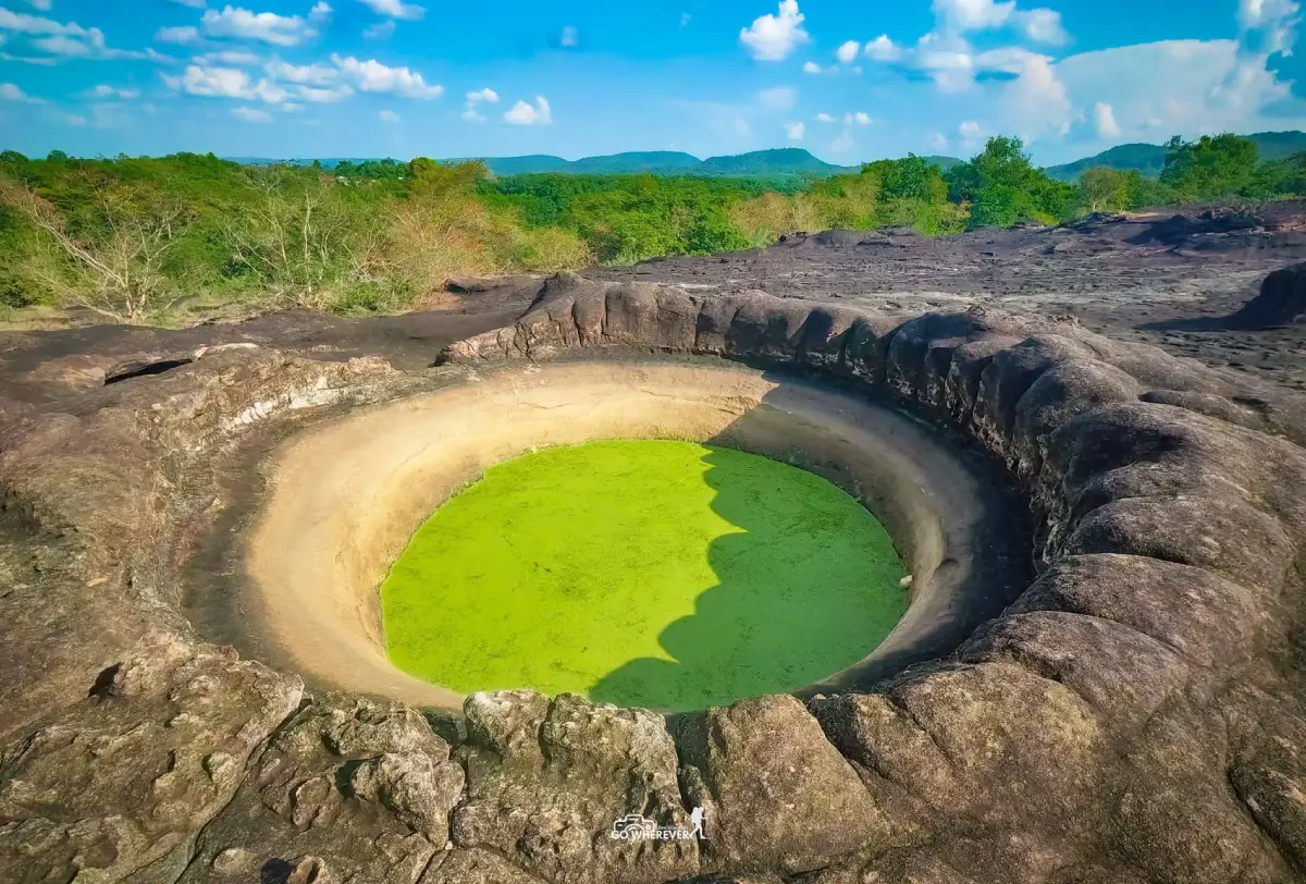
The Volcanic Rock Outcrop at Ban Phon Sawang is located within Wat Doi Roi Phra Phutthabat in Phang Daeng Subdistrict, Dong Luang District, Mukdahan Province. The site features an extensive natural rock platform containing numerous large circular and oval depressions locally described as ancient volcanic vents. It is also a Buddhist place of worship associated with a sacred footprint. The name is an established local tourism name, but the area has not been scientifically confirmed as an ancient volcanic crater. Regional geological information places much of Dong Luang within the sedimentary Khok Kruat Formation.
The Volcanic Rock Outcrop in Mukdahan, locally known as Khod Hin Phukhao Fai, is situated at Ban Phon Sawang, Moo 6, Phang Daeng Subdistrict, Dong Luang District. The rock field is now part of Wat Doi Roi Phra Phutthabat, also known locally as Wat Phra Phutthabat Dong Luang. It consists of a broad natural stone platform surrounded by the rural forest and upland landscape of Dong Luang. Numerous large depressions appear across the exposed surface. Many are approximately circular or oval, and long-established tourism descriptions state that some measure about 3–5 meters across.
The unusual number and scale of these depressions make the site visually different from an ordinary rocky terrace. Visitors come to observe the formations, photograph the landscape, pay respect at the Buddhist sanctuary, and explore a lesser-known part of Mukdahan Province. The destination is quiet and only lightly developed, making it particularly suitable for travelers interested in local nature, community heritage, geological interpretation, and rural Buddhist culture.
The name “Volcanic Rock Outcrop,” together with the description “ancient volcanic vents,” has been used for many years by the community, local authorities, and tourism media. Traditional descriptions explain the large holes as openings or gas vents formed while volcanic lava was cooling. The name has become an important part of the destination’s identity. However, a tourism name and a scientific geological classification are not necessarily the same thing.
Regional geological information published by Thailand’s Department of Mineral Resources places a broad part of Dong Luang District within the Khok Kruat Formation, a sedimentary unit of the Khorat Group. The formation contains sandstone, siltstone, mudstone, and other sedimentary rocks deposited in an ancient river environment. It dates to approximately 100–125 million years ago, during the later part of the Early Cretaceous Period.
This sedimentary setting differs from scientifically confirmed ancient volcanic areas, where geologists normally identify volcanic igneous rocks such as basalt, rhyolite, or andesite, together with mineralogical, structural, and landform evidence of volcanic activity. The Department of Mineral Resources lists important ancient volcanic areas in provinces including Buri Ram, Nakhon Ratchasima, Surin, Si Sa Ket, Ubon Ratchathani, Lampang, Lop Buri, Nakhon Sawan, Phichit, and Loei. Mukdahan is not included in that confirmed list.
The most accurate way to understand the site is therefore to treat “Volcanic Rock Outcrop” as its established local and tourism name. The visible features are a large natural rock platform containing depressions, basins, channels, and weathered surfaces. Until a detailed site-specific geological investigation identifies volcanic rock and a volcanic structure, the depressions should not automatically be described as genuine lava vents or crater openings.
Circular depressions can develop on rock through several natural processes. Rainwater may collect in small weaknesses, cracks may expand through repeated wetting and drying, differences in rock hardness may cause uneven weathering, and moving sand or gravel can gradually enlarge an existing hollow. In places affected by flowing or swirling water, sediment can grind against the rock and produce rounded basins. Determining which process formed a particular depression requires examination of the rock texture, mineral composition, joints, surrounding layers, and drainage pattern.
This scientific clarification does not make the site less interesting. Instead, the contrast between the local name and the regional geological evidence creates a valuable learning opportunity. Visitors can consider why earlier observers connected the holes with volcanic activity, what evidence scientists require before identifying a volcanic crater, and how local names become part of tourism and community identity.
On entering the rock field, visitors encounter a broad open surface that contrasts with the surrounding vegetation. Some sections are relatively smooth, while others are cracked, irregular, or interrupted by basins and shallow channels. Large depressions occur at several points. During the rainy season, some hold water, fallen leaves, sediment, and small plants, while others remain comparatively dry because of drainage through cracks.
The commonly quoted diameter of 3–5 meters comes from long-standing tourism descriptions and should not be understood as a survey measurement applying to every feature. The actual holes vary in width, outline, depth, and condition. Some are broad and shallow, some have sharply defined edges, and others connect to cracks or natural drainage lines across the rock platform.
The rainy season changes the appearance of the site considerably. Water accumulates in depressions, vegetation grows along the edges and joints, the color of wet rock becomes darker, and the surrounding forest appears greener. This is a useful period for observing drainage and temporary pools, but it is also the most hazardous season for walking because wet stone, algae, mud, and fallen leaves can become extremely slippery.
The cool season, approximately November to February, provides the most comfortable conditions for general sightseeing. Morning temperatures are lower, humidity is reduced, and the rock surface is generally drier than during the rains. Low morning or afternoon sunlight creates shadows around the basins and cracks, making their form easier to see and photograph.
March to May brings drier surfaces and open skies but also intense heat. Exposed stone absorbs and reflects sunlight rapidly, while large parts of the terrace have limited shade. Visitors should arrive early, carry sufficient drinking water, wear a hat, and avoid extended walking around midday. Children and elderly travelers are particularly vulnerable to heat stress on the exposed surface.
The rock field lies within Wat Doi Roi Phra Phutthabat and must be visited as part of a religious place. The temple contains a sacred footprint and spaces used for worship and meditation. Visitors should therefore remain quiet, dress modestly, and avoid behavior that would be inappropriate at a Buddhist monastery. Loud music, alcohol, disruptive group activities, and intrusive photography are unsuitable even though the principal natural area is outdoors.
The name Wat Doi Roi Phra Phutthabat refers to the sacred footprint associated with the site. Footprint traditions occur throughout Thailand, where natural impressions in rock are interpreted through Buddhist belief and become centers of merit-making. Such beliefs often encourage communities to protect the surrounding mountain, forest, and water sources as part of a sacred landscape.
The temple developed from the use of the forested hill as a place for monks and Buddhist practice. It later became an established religious site for Ban Phon Sawang. As the unusual rock formations attracted greater attention, the temple also became responsible for receiving visitors and helping protect the natural terrace. A journey to the site therefore combines geological curiosity, Buddhist faith, and the relationship between a rural community and its environment.
Ban Phon Sawang and Phang Daeng are rural communities surrounded by forest, agricultural land, streams, hills, and small villages. Dong Luang District is also associated with the cultural heritage of the So or Kaso ethnic community, whose language, clothing, music, belief systems, and ceremonies contribute to the identity of the district. Respectful visitors can use the rock outcrop as a starting point for learning about a wider cultural landscape rather than treating it as an isolated photography location.
Local roads are shared by residents, agricultural vehicles, and visitors. Drivers should reduce speed, avoid blocking homes or fields, and seek permission before photographing people or private property. Buying food, drinks, local products, and services within Dong Luang allows tourism income to reach the community directly.
The principal visitor activity is walking around the exposed rock platform. Begin at the temple area, observe any signs, and ask local caretakers which route is currently safe. Walking slowly allows visitors to notice differences in texture, the outlines of depressions, drainage channels, joints, and small plants. Jumping across holes or standing on unstable edges is dangerous because the depth and condition of each feature are different.
Photography requires particular care. A wide-angle view can demonstrate the scale of the terrace and the number of depressions, while a lower camera position can emphasize individual edges. Photographers must not step backward without checking the ground, stand on fractured rims, or climb formations without a safe descent. Tripods should not block the walking route or crush vegetation growing in rock joints.
Drones should not be flown without permission from the temple and relevant authorities. Aircraft noise can disturb monks, people meditating, wildlife, and other visitors. Operators must also comply with Thai registration and aviation regulations. The absence of a ticket office does not mean that unrestricted drone use is permitted.
The site can be an effective outdoor classroom for children. It introduces concepts including weathering, erosion, seasonal water storage, plant adaptation, and scientific verification. Adults can explain that the word “volcanic” forms part of the local name, while proof that a rock formed from lava requires mineralogical and structural evidence rather than appearance alone.
School groups and nature-study groups can record approximate dimensions, sketch the shapes of basins, observe the direction of cracks, and compare dry surfaces with areas containing water. Activities should be arranged with temple permission. Hammers, chisels, chemical tests, and the removal of rock samples are inappropriate unless carried out under an authorized scientific study.
Travelers interested in geology should examine texture and layering rather than focusing only on circular shapes. Basalt is normally dark and fine grained and may contain gas cavities or visible mineral crystals. Sandstone consists of compacted and cemented sand grains and may display bedding, grain texture, and weathering along layers or joints. Accurate identification requires geological mapping and mineral analysis.
Depressions that collect rainwater create small seasonal aquatic habitats. Insects, larvae, microorganisms, and small plants may live in them temporarily. Visitors should not drain the pools, add chemicals, throw food or coins into the water, or enter the depressions. A small change in water quality can rapidly affect organisms confined within a limited volume.
Plants growing on the rock are vulnerable because they survive in shallow sediment exposed to heat, drought, and seasonal flooding. Many occur only along cracks or basin edges where soil accumulates. Leaving established walking areas, collecting flowers, or placing bags on vegetation can cause damage that takes a long time to recover.
Writing names, painting, carving, or attaching permanent decorations to the rock is prohibited. Such actions damage the appearance and obscure natural features that may be useful for future study. Rocks, sand, plants, and water organisms should remain in place rather than being taken as souvenirs.
Open flames are a serious risk during the dry season. Grass and forest vegetation around the terrace can burn quickly, while wind across the open rock can carry sparks into the woodland. Smoking, burning rubbish, and lighting incense outside the area designated by the temple must be avoided. Any temporary fire restriction should be followed immediately.
All waste must be carried out. Bottles, plastic bags, foam containers, and tissue can easily blow or fall into the rock depressions. Food waste attracts animals and changes their natural behavior. Carrying a personal rubbish bag is one of the simplest ways to protect both the temple and the natural site.
Visitors should wear modest clothing because the route passes through a temple. Shoulders should be covered, and shorts or skirts should be of an appropriate length. Hats should be removed when approaching the sacred footprint or other worship areas. Conversations should be quiet around monks and people practicing meditation.
Closed shoes with effective rubber grip are recommended. Sandals may be convenient around the temple but are unsuitable for uneven rock, particularly after rain. Travelers with knee, ankle, or balance problems should remain on the flatter sections and should not attempt to reach every basin.
Essential items include drinking water, a hat, sunscreen, insect repellent, personal medication, a charged telephone, and a bag for waste. This is a rural temple rather than a developed visitor center. Permanent shops and restaurants are not available on the rock terrace, so supplies should be obtained in Dong Luang town before arrival.
Mobile coverage can be inconsistent in forested and upland areas. Save the coordinates, an offline map, and the telephone number of Phang Daeng Subdistrict Administrative Organization before departure. Visitors should remain with their group and should not enter surrounding forest routes without local guidance.
The most suitable daily periods are approximately 08.00–10.30 and 15.00–17.00. Morning offers lower temperatures, while late-afternoon light gives greater definition to edges and cracks. Visitors should not remain on the terrace after dark because lighting does not cover every depression and changes in level become difficult to see.
During thunderstorms, leave the exposed rock platform. It offers little protection from strong wind or lightning, and sudden rainfall makes walking substantially more dangerous. If rain begins during the visit, return to an appropriate temple building or shelter rather than standing beneath an isolated tree.
Elderly travelers can visit the temple and accessible areas, but the rock platform requires individual assessment. Standard wheelchair access is not available throughout the natural surface. Families should select the safest and flattest viewpoints rather than attempting to examine every depression.
Young children must remain under direct adult supervision. They should not run, jump between depressions, or climb into holes. A basin that appears shallow may contain water, mud, branches, or an extremely slippery surface. Adults carrying children must also take care because uneven ground can affect balance.
Pets should not be allowed to run freely. They may fall into a basin, disturb monks or wildlife, or leave waste within a religious area. Anyone who needs to bring an animal should seek permission, use a lead, and remove all waste.
Several attractions in Phang Daeng can be combined with the visit. Wat Phu Kamphra is an important local temple associated with Luang Pu Kham Noi and contains a distinctive chedi. The Anulak Suspension Bridge and Kaeng Khamin Weir offer additional views of the local waterways and community landscape.
Huai Lao Waterfall is another natural attraction within Phang Daeng. It is most suitable during the rainy season and periods of adequate flow. Road and weather conditions should be checked before traveling. A private vehicle and an early departure are recommended when combining the waterfall with the Volcanic Rock Outcrop.
Wat Noi Pa Wai and the Ban Na Lak forest monastic area provide further opportunities to experience rural Buddhist practice. These sites are distributed along local roads with several junctions. Navigation should be combined with directions from residents, particularly where similar village or temple names appear on digital maps.
A half-day itinerary can begin in Dong Luang town and continue approximately 15 kilometers to Wat Doi Roi Phra Phutthabat. Allow 1–2 hours for worship and careful exploration of the rock terrace. Wat Phu Kamphra or the suspension bridge can then be added before returning to the district center for lunch.
A full-day itinerary may include Huai Lao Waterfall, Kaeng Khamin Weir, or Wat Noi Pa Wai. Seasonal conditions and driving time between villages should determine the number of stops. Avoid overloading the schedule and driving on unfamiliar rural roads after dark.
Getting There from Mukdahan city is possible by following Highway 212 toward That Phanom and turning onto Highway 2104, also associated locally with the Prem Pracha route, toward Dong Luang District. From Dong Luang town, continue toward Phang Daeng Subdistrict and Ban Phon Sawang, Moo 6, following signs to Wat Doi Roi Phra Phutthabat. The temple is approximately 15 kilometers from the district center, and the road is paved for most of the journey.
Travelers coming from Kalasin can use Highway 2287 through the Khao Wong–Dong Luang corridor. Those coming from Nakhon Phanom can approach through the That Phanom–Dong Luang route. The coordinates 16.809340, 104.391783 identify the temple area, but local signs and directions from Ban Phon Sawang residents remain useful near the final junctions.
A private or rental vehicle is the most practical option. No regular public bus reaches the temple directly. Travelers using public transport should first reach Dong Luang town and arrange a hired vehicle with a confirmed return time. Passing transport should not be expected near the temple in the late afternoon.
Ordinary cars can reach the site during normal weather conditions. After rain, drivers should slow down where mud, gravel, or agricultural traffic affects local roads. Vehicles must be left in the temple parking area and must never be driven onto the natural rock platform.
The attraction is open daily from 08.00 to 17.00. No admission fee is charged, while donations to the temple may be made voluntarily. Large groups, schools, and organized study visits should contact the temple or Phang Daeng Subdistrict Administrative Organization in advance.
Facilities are limited and correspond to those of a rural temple rather than a major tourism complex. Parking and resting areas are available in limited space. There is no permanent visitor center or commercial service on the rock terrace. Water, food, and other essential supplies should be purchased in Dong Luang before arrival.
For visitor orientation, the site can be described as containing an entrance and parking area, the temple and worship area, the sacred footprint, the main rock platform, the concentration of depressions locally called volcanic vents, and the forest-edge viewpoint. These are descriptive visitor zones rather than officially designated administrative sections.
Most verifiable restaurants are located in Dong Luang town, approximately 15–18 kilometers away. Chompoonick Garden serves coffee, bakery products, and single-dish meals. Krua Chan Chao provides local food on Prem Phatthana Road, while Jungle Cafe Dong Luang and other district cafés offer drinks and rest stops after the visit.
Restaurant hours in a small district can change according to the day and season. Calling businesses with a published number is advisable, particularly for groups or afternoon arrivals. Food packaging and drink containers must not be discarded at the temple or on the rock field.
Accommodation is concentrated in Dong Luang town and nearby areas. Options include Super Tree Hotel, Euro & Yulan Resort, Ida Resort 2, Thew Phai Ngam Resort, and Ban Phak Kanok-on. Staying in town provides easier access to food, convenience stores, fuel, and other basic services than staying near Ban Phon Sawang.
A day trip from Mukdahan city is possible with an early departure. Staying for one night in Dong Luang is more suitable for travelers combining the rock outcrop with Huai Lao Waterfall, Phu Pha Yon National Park, or other community destinations.
Using local restaurants, accommodation, guides, and transport allows tourism income to reach residents. Fair payment and advance notice for group visits support better service and strengthen community interest in conserving the temple and natural terrace.
The site has potential to become a community geological learning area. A detailed geological survey, accurate interpretation signs, a safe walking route, and clear information about important depressions would increase educational value without requiring major construction on the natural surface.
Interpretation should explain the local volcanic name, the regional sedimentary geology, weathering and erosion, and the evidence required to confirm a volcanic crater. Presenting both the community narrative and scientific information preserves local identity without misleading visitors.
Future development should prioritize safe boundaries around hazardous edges, path markers, waste management, wildfire prevention, and training for local interpreters. Pouring concrete over the natural terrace or altering the holes would destroy scenery and geological information that may be valuable for future study.
The Volcanic Rock Outcrop is also an instructive example of language in tourism. An exciting name can attract attention, but responsible information must distinguish between a place name, a community story, a hypothesis, and a conclusion supported by geological evidence. Visitors can continue using the established name while understanding its correct context.
This is a destination for people who value quiet observation rather than commercial entertainment. There are no large attractions, amusement facilities, or extensive shops. Its value lies in walking slowly, examining natural forms, paying respect at the temple, learning about the community, and considering how landscapes are interpreted.
Visitors can preserve this simplicity by leaving no marks, carrying out waste, remaining quiet, staying out of closed forest areas, and sharing accurate information. Responsible photography and factual descriptions help the site become better known without sacrificing its original character.
Before traveling, check the weather and contact Phang Daeng Subdistrict Administrative Organization for current road information. Carry sufficient water and postpone the visit during severe storms or wildfire restrictions. Suitable conditions provide a safer experience and make the rock features easier to observe.
The Volcanic Rock Outcrop at Ban Phon Sawang has value on several levels. Its name reflects community imagination and local storytelling. The terrace demonstrates long natural processes. The sacred footprint represents Buddhist faith, while the temple setting connects environmental conservation with religious stewardship.
The best visit begins in the morning and allows at least 1–2 hours. Wear suitable shoes, start by paying respect within the temple, and then follow a safe route across the rock platform. There is no need to enter the depressions or reach every part of the terrace. Observing from an appropriate distance protects both visitors and the site.
Before leaving, confirm that all belongings and waste have been removed. Do not leave food for animals. A voluntary temple donation or the use of local services can support the community. Travel that respects scientific evidence, Buddhist faith, and local life will help preserve the Volcanic Rock Outcrop as a place of learning and contemplation.
| Name | Volcanic Rock Outcrop at Wat Doi Roi Phra Phutthabat |
| Alternative Names | Khod Hin Phukhao Fai, Ancient Volcanic Vents, Wat Phra Phutthabat Dong Luang |
| Location | Ban Phon Sawang, Moo 6, Phang Daeng Subdistrict, Dong Luang District, Mukdahan Province, Thailand |
| Address | Wat Doi Roi Phra Phutthabat, Ban Phon Sawang, Moo 6, Phang Daeng, Dong Luang, Mukdahan 49140, Thailand |
| Coordinates | 16.809340, 104.391783 |
| Attraction Type | Natural rock terrace, local geology learning site, Buddhist temple, and spiritual attraction |
| Highlights | Extensive exposed rock platform, numerous circular and oval depressions, sacred footprint, forest environment, and the rural landscape of Dong Luang |
| Locally Described Basin Size | Approximately 3–5 meters across, although actual width, shape, and depth vary considerably |
| Geological Context | “Volcanic Rock Outcrop” is a local tourism name. The wider Dong Luang area is associated with the sedimentary Khok Kruat Formation, containing sandstone, siltstone, and mudstone. The site has not been scientifically classified as a confirmed ancient volcanic crater |
| Regional Rock Age | The Khok Kruat Formation dates to approximately 100–125 million years ago in the Early Cretaceous Period |
| Religious Importance | The site lies within Wat Doi Roi Phra Phutthabat and contains a sacred footprint respected by the Ban Phon Sawang community |
| Open Days | Daily |
| Opening Hours | 08.00 – 17.00 |
| Admission Fee | Free admission; voluntary temple donations are welcome |
| Current Status | Open as a Buddhist temple and local attraction and included in current district and subdistrict tourism information |
| Caretakers / Coordinating Authorities | Wat Doi Roi Phra Phutthabat, Ban Phon Sawang community, and Phang Daeng Subdistrict Administrative Organization |
| Main Contact Number | Phang Daeng Subdistrict Administrative Organization: 042-644-756, Monday–Friday, 08.30–16.30 |
| Facilities | Limited temple parking and resting space. No permanent visitor center or commercial service is available on the rock terrace. Bring water and essential supplies from Dong Luang town |
| Main Areas / Zones | 1. Entrance and parking area 2. Temple and worship area 3. Sacred footprint area 4. Main rock platform 5. Rock depressions locally called volcanic vents 6. Forest edge and landscape viewpoint These are descriptive visitor areas, not official administrative zones |
| Recommended Period | November–February for comfortable walking. The rainy season offers green scenery and water-filled basins but slippery surfaces. Hot-season visits should take place in the morning |
| Travel Information | From Mukdahan city, use Highway 212 and turn onto Highway 2104 toward Dong Luang. From the district center, continue toward Phang Daeng and Ban Phon Sawang for approximately 15 km. The road is paved for most of the route |
| Safety | Watch for deep depressions, uneven surfaces, slippery wet rock, and fractured edges. Do not enter the holes, remain after dark, or walk on the exposed terrace during a thunderstorm |
| Visitor Etiquette | Dress modestly, remain quiet, do not write or carve on the rock, do not remove plants or stones, avoid unauthorized fires, and carry out all waste |
| Nearby Tourist Attractions | 1. Wat Phu Kamphra, about 7 km 2. Anulak Suspension Bridge, Phang Daeng, about 9 km 3. Kaeng Khamin Weir, about 11 km 4. Huai Lao Waterfall, about 15 km 5. Wat Noi Pa Wai, about 18 km Distances are approximate road distances from Wat Doi Roi Phra Phutthabat |
| Nearby Restaurants | 1. Chompoonick Garden, Dong Luang, about 15 km, Tel. 082-518-3318 2. Krua Chan Chao, Dong Luang, about 15 km 3. Jungle Cafe Dong Luang, about 16 km, Tel. 092-990-6995 4. Chowdong Coffee, about 16 km 5. Café Amazon in the Dong Luang area, about 17 km Confirm opening hours before traveling |
| Nearby Accommodations | 1. Super Tree Hotel, Dong Luang, about 15 km, Tel. 064-471-4956, 089-445-2642 2. Euro & Yulan Resort, about 16 km, Tel. 095-649-6784 3. Ida Resort 2 Dong Luang, about 16 km, Tel. 065-065-1402 4. Thew Phai Ngam Resort, about 17 km, Tel. 063-635-6969 5. Ban Phak Kanok-on, Dong Luang, about 16 km, Tel. 087-257-6088 |
Frequently Asked Questions (FAQ)
Q: Where is the Volcanic Rock Outcrop in Mukdahan?
A: It is located within Wat Doi Roi Phra Phutthabat at Ban Phon Sawang, Moo 6, Phang Daeng Subdistrict, Dong Luang District, Mukdahan Province. The coordinates are 16.809340, 104.391783.
Q: Is the site a genuine ancient volcanic crater?
A: “Volcanic Rock Outcrop” and “ancient volcanic vents” are established local tourism names. The Department of Mineral Resources has not classified the site as a confirmed ancient volcanic crater, and the wider Dong Luang area is associated with sedimentary rocks of the Khok Kruat Formation.
Q: How did the large rock depressions form?
A: Rock depressions can develop through weathering, rainwater, erosion along cracks, and abrasion by moving sediment. A site-specific geological investigation is required to determine the formation process of each feature.
Q: What are the opening hours, and is there an admission fee?
A: The site is open daily from 08.00 to 17.00. Admission is free, and visitors may make a voluntary temple donation.
Q: What is the best time to visit?
A: November to February offers the most comfortable walking conditions. The rainy season produces green scenery and water-filled basins but slippery rock, while hot-season visits should be made in the morning.
Q: Is the site suitable for children and elderly travelers?
A: The temple area is accessible to most visitors, but the natural terrace contains holes and uneven surfaces. Elderly travelers should remain on flatter sections, and children require continuous adult supervision.
Q: What should visitors bring?
A: Bring closed shoes with good grip, drinking water, a hat, sunscreen, insect repellent, personal medication, a charged telephone, and a bag for carrying out waste.
Q: How do travelers reach the site from Dong Luang town?
A: Drive toward Phang Daeng Subdistrict and Ban Phon Sawang, following signs to Wat Doi Roi Phra Phutthabat. The temple is approximately 15 kilometers from the district center, and the road is paved for most of the journey.
 Category: ●Nature and Wildlife
 Group: ●Other natural attractions
Last Update : 2 MonthAgo
 Last Update : 2 MonthAgo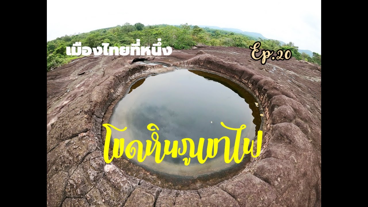
 Click to Access the Navigation Map GPS
Volcanic Rock Outcrop Map
Recommend

 Art, Culture and Heritage
 Historical Sites and Monuments(2)
 Landmarks and Memorials(3)
 Art, Craft Centres, Tradition(2)
 Museums(1)
 Places of Worship
 Temple(17)
 Other Sacred Sites(3)
 Suburban Living
 Village, Community(4)
 Local Market(2)
 National Parks and Marine Reserves(4)
 Mountain (Doi)(5)
 Dam, Reservoir, Lake(3)
 Waterfalls(5)
 Caves(2)
 River, Canal(2)
 Bays and Beaches(1)
Other natural attractions(1)
Bays and Beaches(1)
Other natural attractions(1)
 Entertainment and Agricultural
 Farms, Parks and Ecotourism(1)


