
lovethailand home >Northeastern Travel Attractions >Mukdahan Travel Attractions >Dong Luang >Phang Daeng > Huai Lao Waterfall
TL;DR: Huai Lao Waterfall is located at Ban Huai Lao, Moo 7, Pung Daeng Subdistrict, Dong Luang District, Mukdahan Province, Thailand, open Daily during the open season from 1 June to 31 January; closed annually for, hours 08.00 – 17.00.

Huai Lao Waterfall
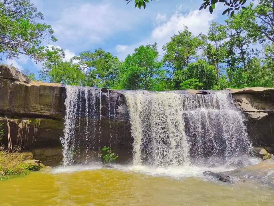
Open Days: Daily during the open season from 1 June to 31 January; closed annually for ecological restoration from 1 February to 31 May
Opening Hours: 08.00 – 17.00
Latest Status: Open for seasonal visitation as of 18 July 2026
Huai Lao Waterfall is an important natural attraction in Dong Luang District, Mukdahan Province. It is located at Ban Huai Lao, Moo 7, Pung Daeng Subdistrict, within the mountainous landscape of the Phu Phan Range and an area managed by Phu Pha Yon National Park. The waterfall is known for clear, cool water flowing across natural rock terraces and boulders before descending through a compact series of cascades. Its quiet, shaded surroundings make it suitable for travelers seeking forest scenery, seasonal streams, nature photography and an opportunity to learn about the communities of Pung Daeng.
The waterfall is most attractive during the rainy season and the beginning of the cool season. Water originating in the forested Phu Phan uplands flows into Huai Lao, passing across rock slabs and uneven formations that create rapids, shallow pools and small cascades. The most visible main drop is approximately 4 metres high. Huai Lao is not a massive waterfall with a towering vertical cliff, but its appeal comes from the clean stream, the naturally formed rock landscape, the surrounding forest and an atmosphere that remains quieter than heavily developed tourist destinations.
When water levels are suitable, the stream spreads across broad sections of rock before collecting in pools below. The sound of water striking the stones creates a relaxing environment, while trees along the stream provide partial shade during the warmer hours of the day. Visitors can rest on safe sections of rock, observe the flow or photograph the landscape without completing a long expedition into remote forest. Water volume, however, depends entirely on rainfall and conditions in the upstream catchment. Travelers should contact Phu Pha Yon National Park before departure, particularly at the beginning of the open season or during a prolonged dry period.
Huai Lao Waterfall is managed by Phu Pha Yon National Park, with National Park Protection Unit PhY.10 (Huai Lao) responsible for local access, visitor safety and natural resource protection. The presence of a ranger unit helps regulate tourism and reduce activities that could damage the forest, stream or wildlife. Visitors should report to the unit or follow posted instructions before approaching the waterfall, especially on days of heavy rainfall, rapidly rising water or temporary restrictions imposed for safety reasons.
The national park closes Huai Lao Waterfall annually from 1 February to 31 May. This period allows natural resources to recover, reduces risk during the dry and forest-fire season, and gives staff time to inspect routes and prepare for the rains. The waterfall then opens from 1 June to 31 January. The annual closure does not mean that the attraction has permanently ceased operating. It is a conservation measure intended to reduce disturbance when water is limited, vegetation is dry and the forest ecosystem is particularly vulnerable.
June and July mark the beginning of the visiting season. Water gradually increases according to rainfall in the catchment. Some years produce a visible flow soon after the season opens, while other years require several weeks of sustained rain. August to October normally provides the strongest and most attractive flow. Forest vegetation becomes deep green, and mosses and small moisture-loving plants spread across damp rocks. From November to January, water volume gradually declines, but the cooler weather becomes more comfortable for walking and relaxation.
Travelers whose main priority is seeing a strong waterfall should consider August to October, while closely monitoring the weather. Heavy rainfall upstream can cause a rapid increase in water even when no rain is falling at the waterfall itself. Visitors seeking cooler air, quieter conditions and easier road access may prefer November to early January. Trails are generally drier and the risk of intense rainfall is lower, although the flow may be less powerful than during the peak rainy months.
The landscape belongs to the Phu Phan mountain environment and includes dry dipterocarp forest, mixed deciduous forest and moisture-dependent vegetation beside the stream. Plant communities vary according to elevation, soil and water availability. Areas farther from the stream are generally more open, while the riparian zone has denser vegetation and species adapted to greater moisture. This contrast allows visitors to observe several ecological conditions within a relatively compact area.
Large trees and undergrowth along the stream help retain moisture, reduce bank erosion and filter sediment before it enters the pools. Tree roots stabilize the soil and slow surface runoff during heavy rainfall. If upstream forest were removed, the stream could become more violent during storms while drying more rapidly during the dry season. Sediment would also increase. Protecting the surrounding forest is therefore directly connected to the clarity, cool temperature and seasonal continuity of Huai Lao Waterfall.
The rock terraces and boulders were shaped by water erosion over a long period. Flowing water entered cracks and passed across uneven surfaces, gradually creating channels, pools and drops. The waterfall is therefore a natural result of rock type, slope and seasonal water force rather than a constructed feature. Some pools may look shallow when the water is clear, but their floors can descend abruptly or contain uneven rock. Depth should never be judged from water color alone.
Clear water is one of the waterfall’s defining qualities. When rainfall is moderate, water from the forested catchment passes across natural soil and rock, allowing stones and gravel to remain visible in shallow areas. After heavy rain, the water may temporarily become cloudy as sediment, leaves and branches are carried downstream. Visitors should avoid entering the stream whenever the water is discolored, fast moving or carrying significant debris, as these are signs of rapidly changing conditions.
Morning is the most suitable time to experience the quiet character of the waterfall. Temperatures are lower, birds and forest insects are easier to hear, and light filtering through the canopy is softer. Visitors interested in walking and photography should arrive between approximately 08.00 and 10.00, allowing sufficient time to explore and return before afternoon rain. Families should avoid arriving shortly before closing because the walk may become rushed and natural light on the return route may be insufficient.
Late morning and midday bring more direct light into the pools, making the color of the water and details of the rocks easier to see. Heat and humidity can also increase, especially on cloudless days. Visitors should take breaks, drink sufficient water and avoid excessive exertion. Although the waterfall is more shaded than exposed countryside, walking over wet rock and sloping ground requires more energy than walking on a level road. Anyone with a health condition should assess their physical ability before entering the route.
Afternoons during the rainy season require particular attention to changing weather. Storm clouds can develop rapidly over the Phu Phan Range, and rain falling upstream can alter the stream within a short period. If the sound of the water becomes noticeably louder, the water changes color, or large quantities of leaves and branches begin to move downstream, visitors must leave the stream and move to higher ground immediately. Stopping to photograph the rising water can place both visitors and rescuers at serious risk.
The visitor area can be understood as several functional sections: National Park Protection Unit PhY.10, where visitors can coordinate with rangers; the natural access route toward the stream; rock terraces and rapids; the main cascade and natural pools; and conservation forest outside the visitor route. These are not highly developed recreational zones with large buildings. They reflect the careful use of a natural area for both visitor safety and environmental protection.
The ranger unit is the appropriate place to ask about water conditions, trail safety, the required departure time and any restrictions in effect that day. Rangers can provide information based on current conditions rather than photographs or reports from another season. Reporting before entering also gives staff an understanding of visitor numbers and allows assistance to be organized more efficiently if an emergency occurs.
The approach to the waterfall is a natural path whose surface changes with rainfall, moisture and water movement. Sections may consist of soil, gravel or exposed rock. Shoes should have strong tread and a secure fit. Smooth sandals and loose footwear are unsuitable for wet stone. When a small channel must be crossed, visitors should use the point recommended by rangers rather than jumping between widely separated rocks or relying on dry branches for support.
Rock terraces provide places to rest and observe the water, but visitors must choose level surfaces away from the edge and free from visible algae. A rock that appears dry can still be slippery because of moisture or moss. Testing the surface gently before placing full body weight on it can reduce falls. Running, chasing and pushing are unsafe, particularly when children or older travelers are present.
Some natural pools may be suitable for cooling the feet or entering the water when rangers permit it and the current is safe. Jumping from boulders, diving or swimming close to the falling water should be avoided. Hidden currents, abrupt changes in depth and underwater obstacles can cause injury. The fact that local visitors entered a pool on a previous day does not mean that conditions are unchanged. Ranger instructions must always take priority.
Conservation forest outside the marked route protects wildlife, the watershed and regenerating vegetation. Visitors should not leave the main path in search of a new photographic angle, collect forest products or explore cliffs and caves without a ranger. Leaving the route increases the risk of becoming lost, encountering venomous animals, slipping on concealed rock and entering an area without mobile phone reception. It also causes unnecessary damage to small plants and fragile soil.
The principal activities at Huai Lao Waterfall are nature observation, quiet relaxation, photography and learning about the stream ecosystem. This destination is more suitable for unhurried nature appreciation than intensive adventure sports. Remaining quiet at a safe viewpoint may reveal birds, butterflies, insects and plants that are easily missed when walking quickly. Groups should limit noise, avoid loudspeakers and share the available space respectfully with other visitors.
Waterfall photography is possible under several lighting conditions. Morning produces soft forest light, while an overcast sky reduces the contrast between bright water and deep shade. A tripod and slow shutter speed can create a smooth appearance in the moving water, but equipment must not block the path or be positioned where it may fall into the stream. Camera bags should not be placed on sloping rock, and waterproof protection is recommended for phones, batteries and electronic equipment.
Drone operators must comply with Thai aviation law and national park regulations. Flying a drone inside a national park requires prior authorization. Drones should never be flown above visitors, close to the ranger unit or in a manner that disturbs wildlife. Noise can alarm birds and animals, particularly during nesting periods. Conventional photography is the appropriate option when official permission has not been obtained.
Families can use the visit to teach children about watersheds, forests and responsible use of natural resources. Close adult supervision is required at all times. Children must not walk out of sight, run on wet rocks or play near deep pools. Rules should be explained before the walk begins, including waiting for an adult at stream crossings, not collecting plants or animals and carrying all rubbish out of the forest.
Older travelers who remain comfortable on uneven ground can visit, but the condition of the path should be considered carefully. On a wet or slippery day, remaining near the ranger unit or an easily accessible section may be safer than attempting to reach every pool. A walking pole, regular medication, drinking water and a companion able to provide support are recommended. Reaching the closest point to the cascade is not necessary for a meaningful experience.
Solo travelers should inform the ranger unit before entering, share the itinerary with a trusted person and establish a clear return time. They should not leave the route or remain at the waterfall near darkness. A charged phone and power bank are useful, although the forest and valleys can cause inconsistent mobile reception. A phone should never be treated as the only safety measure.
Suitable clothing should be breathable, quick drying and protective against insects and branches. Long trousers are preferable to shorts on forest paths. Visitors should carry a hat, a lightweight raincoat, a waterproof bag and a spare set of clothes in the vehicle. Heavy fabrics that retain water and dry slowly are unsuitable. Jewelry and loose objects that may fall into the stream should be left behind.
Recommended supplies include drinking water, low-waste snacks, regular medication, a compact first-aid kit, insect repellent, a towel, a rubbish bag and a flashlight. A raincoat is generally more practical than an umbrella on a narrow forest path. Glass containers should not be taken beside the stream because broken glass is difficult to remove and presents a long-term danger to people and wildlife.
Although the water may appear exceptionally clean, it should not be consumed directly. Natural microorganisms and other contaminants may be invisible. Visitors should carry sufficient drinking water. Food taken into the area should be easy to store and should not produce excessive waste. All leftovers must be removed because abandoned food attracts animals and can change their natural feeding behavior.
Maintaining cleanliness is essential to the continued opening of the waterfall. Plastic bags, bottles, cans, food containers, tissues and cigarette ends must not be left behind. Small items can be carried downstream and dispersed over a wide area. Every group should bring a personal rubbish bag, remove all waste and avoid burning rubbish or pouring food residue into the stream.
Soap, shampoo, detergent and cleaning products must not be used in the waterfall. Even products described as biodegradable can alter water conditions and affect small aquatic organisms. Entering the water should involve only contact with the natural stream. Clothing, dishes and equipment should not be washed in the pools.
Visitors must not carve, write or paint on rocks and trees. A small mark can remain for years and encourage further damage. Rocks, branches and natural material should not be rearranged for photographs. These objects provide shelter for small organisms and may influence water movement. Photographing the site without modifying it is the most responsible approach.
Pung Daeng Subdistrict is connected with local Tai So, also known as Kaso, cultural heritage. Community life has long been associated with forests, streams, agriculture and spiritual beliefs concerning mountains and sacred places. A journey to Huai Lao Waterfall can therefore become an opportunity to understand local culture rather than merely view a cascade. Travelers should respect community life, avoid entering private property and ask permission before photographing individuals at close range.
Community attractions include the conservation suspension bridge, Chao Pu Pha Dam Chedi and Wat Doi Roi Phra Phutthabat. These places reflect both local resource use and spiritual traditions. Combining the waterfall with community sites adds cultural depth to the journey. Visitors entering a temple should dress respectfully, limit noise and follow local rules.
The bridge across Huai Lao at Ban Huai Lao is part of local transport infrastructure connecting Moo 7 with nearby communities. Improved access benefits residents, but visitors must still drive carefully on community roads used by motorcycles, agricultural vehicles, children and domestic animals. Vehicles must not block the entrances of homes or farmland.
Getting There from Mukdahan city involves traveling toward Dong Luang District and continuing onto Highway 2287 on the Dong Luang–Phon Phisai route. From there, turn toward Pung Daeng Subdistrict and Ban Huai Lao, Moo 7, before proceeding to National Park Protection Unit PhY.10. The final section follows local roads whose condition may change with the season. Navigation should be used together with local signs, and the national park should be contacted to confirm the currently available route.
From central Dong Luang, follow Highway 2287 toward Pung Daeng and turn into Ban Huai Lao according to local directions. The journey passes through rural and forested areas. Fuel, tire pressure, brakes and the spare tire should be checked before departure. During the rainy season, vehicles with limited ground clearance should not continue if rangers report standing water, soft ground or damaged road sections.
A private car or motorcycle is the most practical form of transport because scheduled public vehicles do not travel directly to the waterfall. Travelers relying on public transport can first reach Dong Luang and then arrange a local hired vehicle or ask their accommodation to organize transport. The fare, waiting time and return pickup point should be agreed in advance because regular taxis may not be available at the waterfall and mobile reception is inconsistent.
Rainy-season driving requires caution because visibility may be reduced and water, mud, fallen branches or concealed potholes may affect the road. Drivers should never cross flowing water if its depth or the edge of the road cannot be seen. During sustained heavy rain, stopping in a safe location or postponing the journey is preferable to forcing the vehicle through hazardous conditions.
Visitors should aim to arrive before 15.00 even though the area closes at 17.00. This allows time to walk, rest and leave before natural light fades. Late-afternoon arrival also increases exposure to rain and wildlife beginning to move through the forest. Remaining after closing is not permitted unless participating in an activity officially approved by the national park.
A half-day itinerary can begin in Dong Luang during the morning, followed by 2–3 hours at Huai Lao Waterfall and lunch in the district center. The afternoon may include the Pung Daeng conservation suspension bridge, Chao Pu Pha Dam Chedi or Wat Doi Roi Phra Phutthabat. This route reduces unnecessary backtracking and provides time for both nature and community culture.
Travelers with a private vehicle can create a full-day itinerary beginning at Huai Lao Waterfall, continuing to community attractions in Pung Daeng, stopping for lunch in Dong Luang and then visiting Kaeng Pho Waterfall or another section of Phu Pha Yon National Park. The opening status of every location should be confirmed because different areas can close according to trail conditions, rainfall and safety requirements.
Overnight visitors should first consider accommodation in Dong Luang because it is closer to the access route than Mukdahan city. The number of local properties is limited, and several are small businesses, so advance booking is recommended, particularly during public holidays. When local rooms are unavailable, travelers can stay around Na Kae or Renu Nakhon in Nakhon Phanom Province, or use the wider selection in Mukdahan city and depart early in the morning.
Staying in Dong Luang reduces the need for rushed travel and makes an early arrival at the waterfall easier. Mukdahan city offers a greater range of hotels, restaurants and services but requires a longer drive. Travelers should consider road distance, familiarity with rural driving and weather conditions. Anyone uncomfortable with driving after dark should return to the accommodation well before nightfall.
Food services close to the waterfall are limited, and visitors should not assume that a restaurant or shop will be open at the entrance. Meals or snacks should be purchased in Dong Luang before entering Ban Huai Lao. Restaurants in the district provide coffee, made-to-order dishes, som tam, northeastern food and local products. Calling before departure is useful because opening hours can change.
Using community restaurants and local businesses allows tourism income to remain in the area. Visitors should pay fair prices, respect business rules and avoid excessive bargaining. Anyone carrying food to the waterfall is responsible for every item of packaging and should avoid glass containers beside the stream.
If an accident occurs, the ranger unit should be informed immediately. A person suspected of suffering a fracture or head injury should not be moved unless the location presents an immediate threat. The exact position, trail conditions and number of injured people should be communicated clearly. A first-aid kit is useful for minor wounds, but medicine should not be administered without knowing the individual’s allergy history.
Wildlife should be observed from a distance. Animals must not be fed, blocked or chased for photographs. Most wildlife will avoid people when an escape route remains open. If a snake is encountered, stop and move away slowly rather than striking it. Attacking an animal increases the risk of a bite and damages wildlife within a protected area.
Insects and leeches are more common during the rainy season. Insect repellent, long socks and a post-walk clothing check are recommended. Salt and chemicals should not be spread across the forest floor to deter leeches because they affect soil and other organisms. Personal protective equipment is a more responsible solution.
A small waterfall allows visitors to experience natural details at close range, but it also has limited capacity. When a pool or rock terrace is crowded, visitors should wait or select another viewpoint rather than pushing into the same area. Sharing the space reduces accidents and protects the quiet character of the destination.
The value of Huai Lao Waterfall should not be measured only by the height or width of its cascade. Its defining qualities are the forest stream of the Phu Phan Range, its connection with Ban Huai Lao and the simplicity of the setting. Travelers who understand the seasons can observe changes in forest color, water level and stream life that are absent from a permanently engineered attraction.
The annual restoration closure gives the stream and forest a period of reduced disturbance. Rangers can repair routes, remove rubbish, inspect safety conditions and undertake forest-fire prevention, while wildlife benefits from fewer visitors. Entering illegally during the closure is both a violation and a serious safety risk because normal visitor support may not be available.
The latest announcement from Phu Pha Yon National Park should be checked before every visit, even during the open season. Heavy rainfall, flash floods, fire, route repairs or another emergency may result in a temporary closure. A telephone call provides current information about the waterfall, road and rules, reducing the risk of an unnecessary journey.
Before leaving, visitors should check their belongings, remove all rubbish and avoid collecting rocks, plants, seeds or animals as souvenirs. Leaving no physical trace allows future travelers to experience the waterfall in the same condition. Photographs, memories and an improved understanding of the forest are more valuable than any object removed from a protected area.
Huai Lao Waterfall is best suited to travelers who appreciate compact natural attractions, quiet forest scenery and destinations closely connected with local communities. A meaningful visit involves more than photographing the water. It requires planning around the season, following ranger instructions, walking carefully and protecting the site. Responsible use will allow the clear, cool stream of Ban Huai Lao to remain an important natural resource and recreation area for Dong Luang District.
| Name | Huai Lao Waterfall |
| Thai Name | น้ำตกห้วยเลา |
| Location | Ban Huai Lao, Moo 7, Pung Daeng Subdistrict, Dong Luang District, Mukdahan Province, Thailand |
| Protected Area | Phu Pha Yon National Park, Mukdahan Province |
| Caretaker | Phu Pha Yon National Park, Department of National Parks, Wildlife and Plant Conservation, through National Park Protection Unit PhY.10 (Huai Lao) |
| Contact Numbers | Phu Pha Yon National Park: +66 42 707 214 and +66 83 835 9096 Pung Daeng Subdistrict Administrative Organization: +66 42 644 756 |
| Highlights | Clear, cool water flowing across natural rock terraces in a quiet and shaded Phu Phan forest environment |
| Waterfall Characteristics | A seasonal waterfall flowing through rock slabs and rapids, with a main visible drop of approximately 4 metres |
| Forest Environment | Dry dipterocarp forest, mixed deciduous forest and riparian vegetation within the Phu Phan Range |
| Activities | Nature observation, photography, relaxation, stream ecology, birdwatching and learning about Ban Huai Lao community life |
| Main Areas / Zones | 1. National Park Protection Unit PhY.10 (Huai Lao) 2. Natural access path to the stream and waterfall 3. Rock terraces and natural rapids 4. Main cascade and natural pools 5. Conservation forest outside the visitor route |
| Open Days | Daily from 1 June to 31 January |
| Annual Restoration Closure | 1 February to 31 May |
| Opening Hours | 08.00 – 17.00 |
| Best Visiting Period | August to October for stronger water flow; November to January for cooler weather and easier travel |
| Travel Information | From Dong Luang, follow Highway 2287 on the Dong Luang–Phon Phisai route, then turn toward Pung Daeng and Ban Huai Lao, Moo 7. Confirm the final access route with the national park before traveling |
| Recommended Transport | A private car or motorcycle in good mechanical condition; road conditions should be checked during the rainy season |
| Current Status | Open for seasonal visitation as of 18 July 2026 |
| Safety | Be alert for flash floods, slippery rocks and changing water levels. Do not jump from rocks, leave the visitor route or ignore ranger instructions |
| Nearby Tourist Attractions | 1. Ban Huai Lao Bridge, approximately 3 km 2. Pung Daeng Conservation Suspension Bridge, approximately 12 km 3. Chao Pu Pha Dam Chedi, Pung Daeng, approximately 13 km 4. Wat Doi Roi Phra Phutthabat, Pung Daeng, approximately 15 km 5. Kaeng Pho Waterfall, Phu Pha Yon National Park, approximately 34 km |
| Nearby Restaurants | 1. Café Amazon, PTT Dong Luang, approximately 26 km, Tel. +66 96 635 8510 2. Kafae Phloeng, Dong Luang, approximately 27 km, Tel. +66 82 002 7363 3. Som Tam Pa Sadet, Dong Luang, approximately 27 km, Tel. +66 82 920 4629 4. Nong Mai Som Dong Luang, Ban Phon Hai, approximately 36 km, Tel. +66 95 434 1650 5. Jae Yoon Khao Piak Sen, approximately 43 km, Tel. +66 86 244 8413 |
| Nearby Accommodations | 1. Super Tree Hotel Dong Luang, approximately 26 km, Tel. +66 64 471 4956, +66 89 445 2642 2. Thew Phaingam Resort, Dong Luang, approximately 27 km 3. Tara Resort Nakae Renu, approximately 59 km, Tel. +66 81 836 3559 4. Phu Pha Yon National Park Accommodation and Camping Area, approximately 65 km, Tel. +66 42 707 214, +66 83 835 9096 5. Riverfront Hotel Mukdahan, approximately 92 km, Tel. +66 42 612 949 |
Frequently Asked Questions (FAQ)
Q: Where is Huai Lao Waterfall located?
A: Huai Lao Waterfall is located at Ban Huai Lao, Moo 7, Pung Daeng Subdistrict, Dong Luang District, Mukdahan Province, within an area managed by Phu Pha Yon National Park.
Q: During which months is Huai Lao Waterfall open?
A: It is open from 1 June to 31 January and closes annually for ecological restoration from 1 February to 31 May.
Q: What are the opening hours?
A: The waterfall is open from 08.00 to 17.00. Visitors should arrive before 15.00 to allow sufficient time to walk and leave before darkness.
Q: When does Huai Lao Waterfall have the strongest flow?
A: August to October normally provides the strongest flow and greenest forest scenery. November to January offers cooler weather and more comfortable travel.
Q: Can visitors swim at Huai Lao Waterfall?
A: Visitors may enter only pools permitted by rangers when water conditions are safe. Jumping from rocks, diving and approaching strong currents are not permitted.
Q: What type of vehicle is recommended?
A: A private car or motorcycle in good mechanical condition is the most practical choice. Road conditions should be confirmed with Phu Pha Yon National Park during the rainy season.
Q: Is the waterfall suitable for children and older travelers?
A: They can visit, but wet rocks and uneven paths require caution. Children must remain under close adult supervision, and older travelers should have support when walking on slippery ground.
Q: Who should travelers contact before visiting?
A: Contact Phu Pha Yon National Park at +66 42 707 214 or +66 83 835 9096 to confirm the opening status, water level, weather and access route.
 Category: ●Nature and Wildlife
 Group: ●Waterfalls
Last Update : 2 MonthAgo
 Last Update : 2 MonthAgo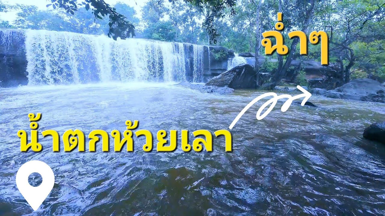
 Click to Access the Navigation Map GPS
Huai Lao Waterfall Map
Recommend

 Art, Culture and Heritage
 Historical Sites and Monuments(2)
 Landmarks and Memorials(3)
 Art, Craft Centres, Tradition(2)
 Museums(1)
 Places of Worship
 Temple(17)
 Other Sacred Sites(3)
 Suburban Living
 Village, Community(4)
 Local Market(2)
 National Parks and Marine Reserves(4)
 Mountain (Doi)(5)
 Dam, Reservoir, Lake(3)
Waterfalls(5)
Dam, Reservoir, Lake(3)
Waterfalls(5)
 Caves(2)
 River, Canal(2)
 Bays and Beaches(1)
 Other natural attractions(1)
 Entertainment and Agricultural
 Farms, Parks and Ecotourism(1)


