
lovethailand home >Northeastern Travel Attractions >Mukdahan Travel Attractions >Don Tan >Na Sa Meng > Tham Phra Phu Wat
TL;DR: Tham Phra Phu Wat, Mukdahan attractions : Nature and Wildlife, Caves.

Tham Phra Phu Wat
Open Days: Daily, subject to the current trail status and confirmation from local officers
Opening Hours: 08.00 – 16.30; visitors should return to the service area before closing time
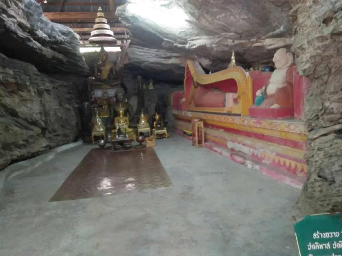
Tham Phra Phu Wat Cave in Mukdahan Province is a mountain sanctuary combining Buddhist faith, open grassland, rocky terrain, and the quiet forest environment of northeastern Thailand. It is located in the Phu Wat area of Na Sameng Subdistrict, Don Tan District, and is associated with the landscape of Phu Sa Dok Bua National Park. After ascending the mountain, visitors reach broad areas of grassland and exposed rock from which they can look across the surrounding landscape near the meeting point of three subdistricts. A revered Buddha image is enshrined inside the cave, while the local community returns during the Songkran festival each year to hold a ceremonial bathing of the Buddha image.
The attraction is not defined by elaborate architecture, commercial facilities, or a large temple complex. Its importance comes from the relationship between the mountain, the cave, the Buddha image, and the people who continue to treat the site as a place of worship. A visit is therefore more than a short stop at a religious monument. Reaching the cave requires travelers to enter a natural mountain environment, follow a trail across uneven ground, and gradually experience the character of the lower northeastern forest landscape.
Phu Wat forms part of a wider group of mountains, sandstone terraces, cliffs, caves, and forest within Don Tan District. The surrounding protected landscape contains dry dipterocarp forest, shallow-soil vegetation, broad rock platforms locally known as dan, natural shelters, and elevated viewpoints. These features create a travel experience very different from visiting an urban temple, where visitors can normally park beside the main religious building. At Phu Wat, the journey through the landscape is an essential part of reaching the sacred place.
The name Tham Phra Phu Wat describes the identity of the site directly. Tham Phra means a cave associated with a Buddha image, while Phu Wat is the local name of the mountain. Although Buddhist ceremonies are held here, the site remains primarily a natural mountain sanctuary rather than a fully developed temple complex. This simplicity preserves a calm atmosphere and allows visitors to experience the Buddha image in a setting shaped by rock, forest, changing daylight, and the quietness of the cave.
The Buddha image serves as a spiritual focus for nearby communities. Local residents climb the mountain to pay respect, make merit, and join religious activities on important occasions. Its role is therefore broader than that of a religious object placed inside a cave. The image brings families, village residents, elders, young people, and people returning to their home communities together during annual observances, especially the Thai New Year period in April.
The placement of a Buddha image in a mountain cave reflects a long-standing cultural understanding of caves and mountains as quiet spaces suited to contemplation. Across Thailand, secluded natural shelters have often been associated with meditation, spiritual retreat, and the establishment of sacred places. At Phu Wat, the absence of monumental buildings does not reduce the religious meaning of the site. Its significance is created by community faith, repeated visits, shared memories, and the care given to the Buddha image and its surroundings.
One of the principal rewards of the ascent is the view from the upper part of Phu Wat. The elevated terrain provides a broad perspective over the landscape around the boundary area of three subdistricts. Forest, agricultural land, villages, and connected mountain ridges can be seen as parts of a single regional landscape. This viewpoint helps visitors understand how communities occupy the lower areas while the mountain terrain continues to function as forest, a natural resource, and a culturally meaningful place.
The grassland is an important visual feature of Phu Wat. Open areas alternate with forest edges, stone platforms, and scattered rock formations. During the rainy season, grasses and small plants become vividly green. In the dry season, the landscape changes to yellow and brown, exposing more of the underlying stone and shallow soil. Travelers returning at different times of the year can therefore encounter significantly different colors, textures, and conditions.
Rock outcrops and broad stone surfaces contribute to the distinctive appearance of the mountain. Some sections are relatively level, while others contain cracks, sloping surfaces, or naturally weathered formations. Visitors must walk carefully, particularly near uneven edges and areas where the rock drops away. Footwear designed for natural trails is essential because ordinary city shoes may provide insufficient grip on loose soil or wet stone.
Phu Wat is particularly suitable for travelers seeking a destination away from large crowds. Along the ascent, natural sounds dominate the environment. Wind, leaves, birds, and insects replace the traffic and commercial noise found at more developed attractions. This slower atmosphere encourages visitors to observe the forest, the direction of the ridges, the changing light, and the details of plants growing in narrow cracks in the stone.
The cave environment contrasts with the open grassland outside. Light and temperature decrease as visitors approach the sheltered interior, while external sounds become softer. Attention naturally shifts toward the Buddha image and the act of worship. Visitors should keep their voices low, avoid blocking the entrance, and give adequate space to people who have come to pray, meditate, or participate in a religious ceremony.
The annual bathing of the Buddha image during Songkran is one of the most important cultural activities associated with Phu Wat. Community representatives involved in consultations for the management plan of Phu Sa Dok Bua National Park specifically referred to activities at Phu Wat, the presence of a large Buddha image, and the Songkran ceremony in which water is poured over the image. This confirms that the mountain continues to function as an active community religious site rather than only a scenic destination.
Bathing a Buddha image has both spiritual and social meaning. Fragrant or clean water is respectfully poured over the image as a symbol of purification, respect, and an auspicious beginning to the Thai New Year. The ceremony allows children, adults, and elders to participate together, transferring cultural knowledge between generations. Memories of preparing offerings, climbing the mountain, meeting relatives, and joining the ceremony become part of the community’s shared heritage.
Travelers attending the Songkran ceremony should follow the instructions of local organizers. Modest clothing is appropriate, and participants should wait for their turn rather than moving ahead of residents involved in the ritual. Photographs of monks, elders, or ceremony leaders should be taken only with permission. The event should be approached as a living religious tradition, not merely as a performance or a background for travel photography.
Songkran is likely to be the busiest period at Phu Wat. Visitors planning to attend must confirm the annual date, gathering point, parking arrangement, and start time with Na Sameng Subdistrict Administrative Organization or Phu Sa Dok Bua National Park. Details can change according to community preparations, weather, trail conditions, conservation requirements, and the number of participants.
Although visitors may enter the wider national park during normal service hours, access to the Phu Wat trail depends on natural conditions. Heavy rain, wildfire risk, maintenance work, habitat restoration, or safety operations may cause officers to restrict access to particular sections. Travelers should always confirm the trail status shortly before departure and should not assume that a route used on a previous visit remains open.
The visitor service hours generally used by Phu Sa Dok Bua National Park are 08.00 to 16.30. An early start is strongly recommended. Travelers need sufficient time to confirm the route, complete the ascent, rest, worship at the cave, explore the viewpoint, and descend before dark. Beginning late in the afternoon may leave inadequate time, particularly for visitors unfamiliar with the terrain or those who walk at a slower pace.
Morning is normally the most comfortable period for the ascent. Temperatures are lower, direct sunlight is less intense, and additional time remains available if the walk takes longer than expected. Morning light can also reveal the texture of the grassland, rock surfaces, and surrounding ridges. By late morning and midday, open stone terraces can become extremely hot because there is less shade than inside the forest.
The cool season from approximately November to February is generally the most suitable period for nature walking. Lower humidity and more moderate temperatures make the ascent more comfortable, while clearer days can provide wider views. Early mornings may be cool and windy on the exposed mountain, so a light outer layer can be useful even when daytime temperatures are warm.
March and April are hot months, but April is culturally important because of the Songkran ceremony. Travelers joining the event should carry enough drinking water, wear a hat, use breathable clothing, and rest regularly. Heat reflected from exposed stone can increase physical fatigue. Heavy bags and a rushed walking pace should be avoided, especially during the middle of the day.
The rainy season transforms the grassland and forest into a greener landscape, but it also creates the most demanding walking conditions. Wet rock becomes slippery, soil trails can turn muddy, and thunderstorms may develop over exposed areas. Visitors should not begin the ascent when severe weather is expected and must comply immediately with any temporary trail closure announced by park officers.
Preparation should begin with suitable footwear. Closed walking shoes with effective grip are preferable to sandals or smooth-soled footwear. Travelers should also carry drinking water, a hat, insect repellent, personal medication, a small amount of food, a charged telephone, and a bag for taking all waste back down the mountain. Clothing should be breathable while remaining modest enough for entering the religious area.
Visitors should not expect shops, restaurants, or regular water stations along the trail. Most facilities are located in nearby communities or around the national park headquarters. Water and food must therefore be prepared before the walk. Disposable foam containers and lightweight plastic packaging should be avoided because they can easily be left behind or blown across the grassland.
Walking alone is not recommended, especially for first-time visitors. A local guide, community representative, or park officer can help confirm the correct route and identify areas that are temporarily closed. Local guidance also improves the experience by providing information about place names, the religious significance of the cave, community practices, and the natural features found along the route.
Mobile telephone coverage can be inconsistent in mountain areas. Travelers should not rely solely on online navigation. Downloading an offline map, informing another person of the planned route, and agreeing on a return time are sensible precautions. Anyone who becomes uncertain about the route should stop and return to the last recognizable point rather than continuing in an assumed direction.
Elderly visitors, young children, people with medical conditions, and travelers with limited mobility should assess the trail carefully before beginning. The route includes natural slopes, uneven stone, and changes in level and is not designed for wheelchairs. Families should carry lighter equipment, allow more rest time, and choose only the sections appropriate for the physical ability of all members.
Photography is rewarding because the site offers grassland, rocks, elevated views, forest, and the cave sanctuary. However, photographers should never step backward toward a cliff edge or rock fissure to improve a composition. Climbing on the Buddha image, its base, offerings, or fragile rock formations is inappropriate. Inside the cave, tripods and bags should not obstruct access for worshippers.
Drones must not be operated without the necessary permission. Phu Wat is connected to a protected national park landscape and may contain wildlife sensitive to noise and disturbance. Drone operations can also disrupt religious ceremonies and the experience of other visitors. Anyone requiring aerial photography must obtain approval from the relevant authorities and comply with all aviation regulations.
Modest behavior is required near the Buddha image. Hats should be removed when approaching the sacred area, feet should not be deliberately pointed toward the image, and offerings should not be moved. Incense and candles may be restricted because smoke and fire create risks inside a cave and in dry forest. Visitors must follow the instructions provided on the day of the visit rather than assuming that open flames are permitted.
Fire prevention is especially important during the dry season. Dry grass and dipterocarp forest can ignite quickly. Cigarette ends, hot charcoal, candles, and burning paper must never be discarded in the area. Where officers request worship without fire, visitors should respect that requirement. Protecting the forest and the sanctuary is more important than following a ritual practice that is unsafe under current conditions.
The mountain remains a habitat for wildlife. Birds, insects, reptiles, and animal tracks may be encountered along the route. Wildlife must not be chased, captured, fed, or removed. Travelers should avoid entering dense vegetation unnecessarily and should check the ground and nearby rocks before sitting. Respectful observation reduces risk for both people and animals.
Small plants growing in stone cracks are particularly vulnerable. They survive in shallow soil with strong sunlight and limited water. Leaving the trail, collecting flowers, or repeatedly stepping on these plants can cause damage that takes a long time to recover. Visitors should remain on the route indicated by local guides or park officers and avoid vegetated depressions in the rock.
Leave-no-trace travel is essential at Tham Phra Phu Wat. Everything carried up the mountain should be carried back down. Names must not be written on cave walls, trees, or stone surfaces. Rocks should not be rearranged into new piles, and religious objects should remain where the community has placed them. Small individual actions can accumulate into major environmental and cultural damage.
The destination is suited to travelers interested in Buddhist culture, community traditions, landscape photography, and moderate nature walking. It is less suitable for visitors expecting full commercial services on the mountain. Toilets, parking, visitor information, and accommodation are concentrated around the national park headquarters and nearby communities rather than at the cave itself.
Families can use the visit as an outdoor learning experience. Children can observe how plants adapt to rock and shallow soil, identify differences between grassland and forest, and learn why a mountain cave has become a sacred place. Adults must supervise children continuously, especially around open rock platforms, slopes, and the cave entrance.
Phu Wat is also valuable as a cultural landscape, a place where natural geography and human meaning have developed together. The mountain and cave are natural features, while the Buddha image, Songkran ceremony, and community memories represent human relationships with that environment. The combined value is greater than either the natural or religious element considered separately.
Nearby archaeological evidence adds further depth to the journey. Phu Pha Taem, located within the same wider mountain landscape, contains prehistoric paintings and handprints on a rock shelter. These remains demonstrate that people have known and used the mountains of this region for a very long period. A combined visit allows travelers to consider changing relationships with the landscape, from prehistoric activity to contemporary Buddhist worship.
Visitors to the prehistoric paintings must not touch the rock surface, apply water to improve visibility, or add markings of any kind. The images are irreplaceable cultural evidence. Combining Phu Wat with Phu Pha Taem should therefore be treated as an educational and conservation-focused journey rather than an opportunity to handle or physically interact with archaeological remains.
Pha Makluea is another nearby rock shelter and rest area that may be included when the relevant route is open. Shaded vegetation and stone formations provide a useful stopping point between the Phu Pha Taem and Phu Wat areas. Trail connections should be confirmed with officers because seasonal conditions can change the time and difficulty of the walk.
Phu Pha Hom is an important viewpoint within Phu Sa Dok Bua National Park. It can be combined with Phu Wat by travelers who have sufficient time and physical preparation. Attempting too many viewpoints in one day, however, can result in a late descent. A smaller itinerary completed safely is preferable to rushing between sites after the recommended return time.
Huai Hin Kho Reservoir and the national park headquarters provide a practical beginning and end to the trip. Travelers can obtain route information, use toilets, park vehicles, and confirm regulations before entering the mountain. The reservoir also illustrates how water, forest, and elevated terrain function together within the protected landscape.
Phu Sa Dok Bua, the mountain that gives the national park its name, contains natural rock pools in which small lotus plants grow. Visiting it normally requires more time and separate planning. Travelers wishing to combine Phu Sa Dok Bua with Tham Phra Phu Wat should consult officers and reserve a full day rather than adding the route to a short visit without preparation.
A half-day itinerary should focus primarily on Tham Phra Phu Wat. Visitors can contact officers in the morning, complete the ascent, worship at the cave, enjoy the grassland and rock viewpoint, and return to the headquarters area. If time and conditions allow, Huai Hin Kho Reservoir or another easily accessible nearby point can be added without creating a rushed schedule.
A full-day itinerary may include Phu Pha Taem, Pha Makluea, or Phu Pha Hom, depending on officer guidance and current trail conditions. There is no requirement to visit every location in a single day. Allowing sufficient time to study the paintings, observe the forest, and understand the religious meaning of Phu Wat produces a more valuable experience than collecting photographs as quickly as possible.
Getting There is most convenient by private car or rental vehicle. From Mukdahan city, travel toward Don Tan District and join Highway 2277 on the Don Tan–Loeng Nok Tha route. The entrance to Phu Sa Dok Bua National Park lies between kilometer markers 24 and 26, approximately 1 kilometer from the main road. The headquarters is near Huai Hin Kho Reservoir at Ban Nong Mek, Pa Rai Subdistrict. Visitors should stop there first and obtain directions to the current Phu Wat trailhead.
Travelers approaching from Don Tan should head toward Na Sameng and the national park area. Entering only the name Phu Wat into a navigation application may lead to a mountain reference point rather than a usable parking area or trailhead. The national park headquarters or Na Sameng Subdistrict Administrative Organization should be used as the initial destination for obtaining local instructions.
The coordinates 16.242012, 104.786352 refer to the general Phu Wat mountain area. They should not be treated as confirmed coordinates for the cave entrance or parking area. Drivers must not follow a direct navigation line into farm roads, patrol tracks, or restricted forest routes. Some roads may be unsuitable for ordinary vehicles, particularly after rain.
Public transportation does not provide direct access to the trailhead. Travelers without a car should first reach Mukdahan city or Don Tan town and arrange a hired vehicle that can wait or return at an agreed time. Price, pickup point, and return time should be confirmed clearly because passing vehicles are not regularly available near the mountain.
Ordinary vehicles can reach the main road and national park headquarters, while access to smaller roads depends on actual conditions. Vehicles with greater ground clearance may be more suitable for uneven roads, but no vehicle should enter a track closed or restricted by officers. Parking must not obstruct community roads, agricultural access, fire-control routes, or park operations.
Before departure, contact the Phu Sa Dok Bua National Park visitor center at 042-620-615 to confirm service hours, trail access, meeting points, current fees, accommodation, and guide requirements. Na Sameng Subdistrict Administrative Organization can be contacted at 042-676-350 for information about the community, the Songkran ceremony, and local coordination concerning Phu Wat.
No regular direct admission charge for the cave has been publicly established. Because the site is associated with the national park landscape, travelers may need to pay national park entrance, vehicle, accommodation, or guide fees according to the rates applicable on the date of travel. Confirming all charges directly prevents reliance on outdated online information.
Main facilities are located around the national park headquarters. These include the visitor center, toilets, parking, and park accommodation. Commercial services are not available throughout the Phu Wat trail or at the cave, so visitors must carry their own water and essential equipment and use the facilities before beginning the ascent.
For practical travel planning, the visit can be understood as passing through the coordination and trailhead area, the ascent route, open grassland, rock platforms and viewpoint areas, the cave and Buddha image, and the ceremonial area used during Songkran. These are descriptive visitor areas rather than formally designated national park zones.
Food options close to the mountain are limited. Most restaurants are located in Na Sameng or Don Tan town. Rung Rueang Kitcha Farm operates as an agricultural attraction, café, and homestay in Na Sameng, while Don Tan offers local establishments such as Krua Ton Kla Don Tan, Krua Sam Sahai, the local Hainanese chicken rice shop, and Had Hin Rim Khong Restaurant.
Travelers should allow approximately 30 to 45 minutes to reach restaurants in Don Tan after leaving the mountain, depending on the destination and road conditions. Small local restaurants may close on particular days. Calling establishments with a publicly confirmed number is recommended for groups or for travelers expecting to arrive late in the afternoon.
The closest accommodation is at Phu Sa Dok Bua National Park headquarters, including Phu Sa 101, also known as Rim Thara, and Phu Sa 102, also known as Phu Pha Hom. Reservations must be confirmed directly with the park. Rung Rueang Kitcha provides homestay accommodation in Na Sameng, while guesthouses and riverside resorts in Don Tan offer additional food and services at a greater distance.
A day trip from Mukdahan city is possible, but departure should be early enough to allow for driving, coordination, walking, rest, and the return journey. Staying near the national park or in Don Tan for one night is more comfortable for travelers combining several mountain and archaeological sites.
Using local accommodation, food services, community guides, and locally produced goods helps distribute tourism income directly to residents. Fair payment for services encourages continued community involvement in trail care, visitor safety, and the preservation of religious traditions.
Tourism development must balance visitor convenience with conservation. Extensive construction, roads, or commercial facilities on the mountain could alter the grassland, rock terraces, and spiritual character of the cave. Appropriate development should prioritize clear signs, safe rest points, waste management, trained guides, and emergency communication rather than large buildings.
Local recommendations submitted during the national park management planning process have included improved nature trails, clearer interpretation signs, and opportunities for community products. Any development within the protected area must follow national park procedures and be coordinated with the responsible authorities.
Clear information improves both conservation and visitor safety. Trail signs should communicate distance, expected walking time, difficulty, hazards, and religious etiquette. Visitors must read the signs, remain on the established route, and avoid creating shortcuts. Concentrating use on a managed path reduces damage and makes emergency assistance more effective.
Tham Phra Phu Wat also has strong potential as a place to understand Songkran beyond urban water celebrations. The local ceremony emphasizes merit-making, respect, collective participation, and a journey to a sacred mountain location. It demonstrates that Thai New Year traditions include spiritual renewal and community responsibility as well as enjoyment.
Foreign visitors benefit greatly from traveling with a local guide who can explain the meaning of bathing the Buddha image, removing shoes, wai etiquette, and appropriate conduct. The community should not be treated as scenery for tourism. Residents are the custodians of the ceremony and the people who maintain the cultural meaning of the site.
The value of Tham Phra Phu Wat depends on several connected elements: the Buddha image, the cave, the mountain environment, the grassland, the stone formations, the wide view across local boundaries, and the annual Songkran gathering. Damage to any of these elements would reduce both the travel experience and the cultural integrity of the place.
Visitors can help protect the site by confirming access before traveling, using the designated trail, carrying out all waste, avoiding open fires, keeping noise low, respecting worshippers, and leaving plants, rocks, and religious objects untouched. These actions require little effort but have a direct effect on the long-term condition of the mountain.
Tham Phra Phu Wat reveals a side of Mukdahan beyond the Mekong riverside and urban attractions. The province also contains mountains, forest, stone plateaus, prehistoric evidence, Buddhist sanctuaries, and communities that continue to use natural places for living traditions. The journey is therefore an opportunity for travel, cultural learning, and a deeper understanding of the relationship between people and landscape.
Travelers who arrive prepared and behave respectfully will encounter a simple but meaningful destination. Walking through grassland and rock outcrops, viewing the meeting landscape of three subdistricts, worshipping at the cave, and learning about the annual Buddha-bathing ceremony make Phu Wat distinctive without the need for monumental construction or commercial entertainment.
Every visit should begin with confirmation from Phu Sa Dok Bua National Park or Na Sameng Subdistrict Administrative Organization. Start early, carry adequate water and equipment, and return before 16.30. Careful planning provides a safer and more rewarding experience while helping preserve this mountain sanctuary for the local community and future travelers.
| Name | Tham Phra Phu Wat Cave |
| Location | Phu Wat area, Na Sameng Subdistrict, Don Tan District, Mukdahan Province, Thailand |
| Coordination Address | Na Sameng Subdistrict, Don Tan District, Mukdahan 49120, and Phu Sa Dok Bua National Park Headquarters, Ban Nong Mek, Pa Rai Subdistrict, Don Tan District |
| Reference Coordinates | 16.242012, 104.786352; these coordinates identify the general Phu Wat area, not a confirmed cave entrance or parking point |
| Reference Elevation | Approximately 373 meters above sea level in the Phu Wat reference area |
| Highlights | Buddha image inside the cave, open grassland, stone platforms, rock formations, views across the boundary landscape of three subdistricts, and the annual Songkran Buddha-bathing ceremony |
| Distinctive Character | A community Buddhist sanctuary in a natural mountain setting associated with the forest and rock landscape of Phu Sa Dok Bua National Park |
| Cultural Importance | A place for worshipping the Buddha image and for community participation in the Songkran bathing ceremony |
| Important Tradition | Annual bathing of the Buddha image during Songkran; the current schedule should be confirmed with Na Sameng Subdistrict Administrative Organization |
| Name Origin | Tham Phra refers to the cave containing a Buddha image, while Phu Wat is the local name of the mountain |
| Open Days | Daily, provided the Phu Wat trail is open under current park and safety announcements |
| Opening Hours | 08.00 – 16.30; begin in the morning and return to the visitor service area before closing |
| Current Status | Active community sanctuary and nature destination within the wider Phu Wat–Phu Pha Taem landscape; trail access must be confirmed before travel |
| Fees | No regular direct cave admission charge has been published; national park, vehicle, accommodation, or guide fees should be confirmed for the date of travel |
| Caretakers / Coordinating Authorities | Phu Sa Dok Bua National Park, Na Sameng Subdistrict Administrative Organization, and local Phu Wat communities |
| Main Contact Numbers | Phu Sa Dok Bua National Park Visitor Center: 042-620-615 Na Sameng Subdistrict Administrative Organization: 042-676-350 |
| Facilities | Visitor center, toilets, parking, and accommodation are available around the national park headquarters; services are limited on Phu Wat, and visitors must carry water and essential equipment |
| Main Areas | 1. Coordination point and trailhead 2. Mountain ascent route 3. Grassland area 4. Stone platforms, rock formations, and viewpoints 5. Cave and Buddha image 6. Area used for the Songkran Buddha-bathing ceremony |
| Difficulty | Natural mountain trail with slopes, uneven rock, and changes in level; suitable footwear and local route guidance are recommended |
| Recommended Period | November–February for more comfortable nature walking; April for the Songkran ceremony; rainy-season visits require additional caution and confirmation of trail access |
| Travel Information | Drive to Don Tan District and use Highway 2277 on the Don Tan–Loeng Nok Tha route. The national park entrance is between kilometer markers 24 and 26, approximately 1 km from the main road. Stop at the headquarters before proceeding to the current Phu Wat trailhead |
| Visitor Etiquette | Dress modestly, remain quiet, carry out all waste, do not light fires without permission, do not mark cave walls or rocks, stay on the route, and do not remove plants, stones, or religious objects |
| Nearby Tourist Attractions | 1. Phu Pha Taem Prehistoric Rock Art Site, about 1 km 2. Pha Makluea, about 2 km 3. Huai Hin Kho Reservoir and Phu Sa Dok Bua National Park Headquarters, about 2 km 4. Phu Pha Hom, about 3 km 5. Phu Sa Dok Bua, about 5 km Distances are approximate from the Phu Wat area; the actual walking route depends on current access arrangements |
| Nearby Restaurants | 1. Rung Rueang Kitcha Farm Café, Na Sameng, about 18 km, Tel. 065-454-5985 2. Krua Ton Kla Don Tan, about 26 km 3. Krua Sam Sahai, Don Tan, about 27 km 4. Hainanese Chicken Rice Shop, Don Tan, about 27 km 5. Nong Naen Restaurant, Don Tan, about 28 km 6. Had Hin Rim Khong Restaurant, about 34 km, Tel. 062-107-1255, 097-049-3423 |
| Nearby Accommodations | 1. Phu Sa 101 or Rim Thara Park House, about 2 km, Tel. 042-620-615 2. Phu Sa 102 or Phu Pha Hom Park House, about 2 km, Tel. 042-620-615 3. Rung Rueang Kitcha Homestay, Na Sameng, about 18 km, Tel. 065-454-5985 4. Mekong View Guesthouse, Don Tan, about 28 km 5. Had Hin Rim Khong Restaurant & Resort, about 34 km, Tel. 062-107-1255, 097-049-3423 |
Frequently Asked Questions (FAQ)
Q: Where is Tham Phra Phu Wat Cave?
A: It is located in the Phu Wat area of Na Sameng Subdistrict, Don Tan District, Mukdahan Province, within the wider landscape associated with Phu Sa Dok Bua National Park. Visitors should confirm the current trailhead before ascending.
Q: What are the opening hours of Tham Phra Phu Wat?
A: Visitors should follow the national park service hours of 08.00 to 16.30, begin the walk in the morning, and return to the service area before closing time.
Q: Is there an admission fee for Tham Phra Phu Wat?
A: No regular direct cave admission charge has been published. National park, vehicle, accommodation, or local guide fees may apply according to the rates in effect on the date of travel.
Q: What are the main highlights of Tham Phra Phu Wat?
A: The highlights include the Buddha image inside the cave, open grassland, rock platforms and formations, views across the boundary landscape of three subdistricts, and the annual Songkran Buddha-bathing ceremony.
Q: When is the Buddha-bathing ceremony held at Phu Wat?
A: The ceremony is associated with the annual Songkran festival in April. The exact date and program should be confirmed with Na Sameng Subdistrict Administrative Organization.
Q: Can visitors drive directly to the cave?
A: Visitors should drive to the coordination point or current trailhead and then continue along the natural mountain route. Vehicles must not enter minor tracks, patrol roads, or restricted areas without officer approval.
Q: What should travelers bring for the visit?
A: Bring closed walking shoes with good grip, drinking water, a hat, insect repellent, personal medication, light food, a fully charged telephone, and a bag for carrying all waste back down.
Q: Is the trail suitable for children and elderly travelers?
A: The route includes slopes, uneven stone, and changes in level. Children, elderly travelers, and people with limited mobility should assess their physical condition and confirm the current trail difficulty before traveling.
 Category: ●Nature and Wildlife
 Group: ●Caves
Last Update : 2 MonthAgo
 Last Update : 2 MonthAgo
 Click to Access the Navigation Map GPS
 Art, Culture and Heritage
 Historical Sites and Monuments(2)
 Landmarks and Memorials(3)
 Art, Craft Centres, Tradition(2)
 Museums(1)
 Places of Worship
 Temple(17)
 Other Sacred Sites(3)
 Suburban Living
 Village, Community(4)
 Local Market(2)
 National Parks and Marine Reserves(4)
 Mountain (Doi)(5)
 Dam, Reservoir, Lake(3)
 Waterfalls(5)
Caves(2)
Waterfalls(5)
Caves(2)
 River, Canal(2)
 Bays and Beaches(1)
 Other natural attractions(1)
 Entertainment and Agricultural
 Farms, Parks and Ecotourism(1)


