
lovethailand home >Northeastern Travel Attractions >Mukdahan Travel Attractions >Muang Mukdahan >Mukdahan > Phu Pha Jia
TL;DR: Phu Pha Jia, Mukdahan attractions : Nature and Wildlife, Mountain (Doi).

Phu Pha Jia
Open Days: The lower area around Wat Weluwanaram is accessible daily in accordance with temple activities. Access to the mountain trail, viewpoints, and caves should be arranged with the local caretakers in advance.
Opening Hours: No official public opening and closing hours have been announced for the mountain route. Visitors are advised to enter between 06:00 and 17:00 and return before dark.
Phu Pha Jia in Mukdahan Province, sometimes pronounced or written locally as Phu Pha Kia, Phu Pha Jia, Phu Pha Chia, or Phu Pha Jea, is a rocky mountain and natural viewpoint close to Mukdahan city. The mountain lies in Mukdahan Subdistrict, Mueang Mukdahan District, with Wat Weluwanaram, also known as Wat Phu Pha Jia, situated near its base. Its landscape includes an uphill trail, exposed rock, forested ridges, natural shelters, caves, and viewpoints overlooking Mukdahan city, the Mekong River, and parts of the landscape across the river in Laos.
The mountain is also associated with locally named caves, including Tham Suea Yai, or the Great Tiger Cave, and Tham Phra, or the Buddha Cave. Bats occupy several cavities and dark rock shelters within the mountain. Beyond the main ridge, local oral history refers to a former radar location or military-related structures connected with American personnel during the Cold War. The surviving public evidence is not sufficient to identify a radar model, military unit, construction date, or confirmed mission, so the story should be understood as community oral history rather than a fully documented military site.
Phu Pha Jia offers a form of nature travel that is unusual for a site so close to an urban area. Travellers can leave Mukdahan city and reach a quiet temple, forest trail, cave environment, and elevated viewpoint without travelling deep into a national park. The main viewpoint is reached by an uphill walk of approximately 1 kilometre. The distance is not long, but sections of loose stone, dry leaves, wet roots, and unclear junctions require appropriate footwear and careful route planning.
The official spelling used by Muk Subdistrict Municipality is Phu Pha Jia. Municipal records identify Wat Weluwanaram, or Wat Phu Pha Jia, as a temple in Village No. 5 of Mukdahan Subdistrict. The mountain is associated with communities around Ban Dan Kham and Ban Kut Ngong, whose residents use the area for religious activity, exercise, local traditions, nature learning, and community events.
The terrain consists of a forested hill, rocky ridges, open sandstone surfaces, cliffs, natural shelters, and cavities produced by cracking and long-term weathering. Deeper soil supports taller trees and shrubs, while exposed ridges contain drought-tolerant vegetation, grasses, and plants rooted in narrow rock fractures. The condition of the trail changes substantially between seasons.
During the rainy season, soil becomes soft, exposed rock develops slippery algae, and water may move through cracks and low passages. In the dry season, leaves accumulate on the ground and increase both slipping and wildfire risk. Visitors should never assume that a route which was easy during a previous visit will remain in the same condition throughout the year.
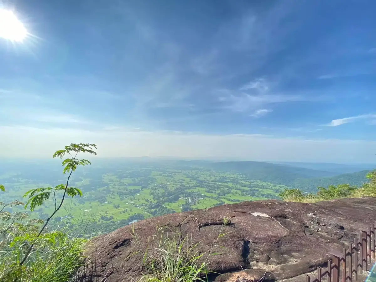
The viewpoint is one of the principal reasons to climb Phu Pha Jia. From open areas on the ridge, visitors can see the urban landscape of Mukdahan, residential areas, roads, farmland, and the Mekong River. In clear weather, the landscape beyond the river in Laos can also be distinguished. The contrast between the quiet forest and the expanding city below gives the mountain a strong sense of place.
Early morning is generally the most suitable time to climb. Temperatures are lower, the eastern sky provides good light, and mist or moisture may remain above the lowlands and Mekong River. Visitors planning to reach the viewpoint for sunrise should not enter the trail alone in complete darkness. Some junctions are not continuously signposted and may lead towards caves or less frequently used ridges.
A headlamp is essential for a pre-dawn walk. Each group should also save the starting location, carry an offline map, and inform a temple or community caretaker of its intended route. Travelling with at least 2–3 people provides additional safety if someone is injured, loses the route, or develops a medical problem.
As daylight reaches the ridge, the forest becomes active with birds and insects. Visitors should select stable ground for resting and remain well behind cliff edges. Rock at the edge of a viewpoint may contain hidden fractures or rest on only a thin layer of soil. A dramatic photograph does not justify standing on an unsupported overhang.
Phu Pha Jia contains several rock cavities and caves formed by natural cracking, movement, erosion, and weathering. Some are shallow shelters reached by daylight, while others extend into darker and more enclosed spaces. The cave names used by villagers and hikers may vary, and their precise positions are not always shown on publicly available maps.
Tham Suea Yai, translated as the Great Tiger Cave, is a local name for one of the mountain’s notable rock cavities. The name may preserve memory, imagination, or older stories about wildlife, but it should not be interpreted as evidence that tigers currently occupy the cave. No visitor should enter expecting to find a tiger or claim a modern tiger record without a verified wildlife survey.
The cave area contains uneven rock, low passages, loose fragments, and surfaces which may become slippery. Before entering, visitors need to assess ceiling height, cracks, footing, air circulation, and recent weather. Rock that appears solid can contain unstable sections. Pulling, climbing, or dislodging material from a cave wall is dangerous and damages the site.
Rain falling on the upper mountain can enter fractures and reach a cave after a delay. A dry entrance does not guarantee a dry interior. Caves should not be entered during thunderstorms, prolonged rain, or immediately after intense rainfall. Narrow passages may collect water quickly and become difficult to exit.
Tham Phra, or the Buddha Cave, reflects the close relationship between natural rock shelters and Buddhist practice in Thailand. Caves and overhangs have long served as quiet places for meditation, temporary monastic retreat, and the installation of Buddha images. Visitors should enter respectfully, avoid loud conversation, and never move Buddha images, offerings, candles, or objects associated with worship.
Clothing should be appropriate for both a temple and a forest trail. Shoulders and legs should be reasonably covered, while the fabric should remain breathable and practical for climbing. Visitors must not sit on a Buddha-image platform, point their feet towards an image, or use an altar as a surface for bags and camera equipment.
The natural floor may remain uneven and slippery even when a sacred section requires shoes to be removed. Visitors should follow caretaker instructions regarding footwear. Shoes must not block an entrance, and everyone should inspect the ground before stepping barefoot onto rock, as sharp fragments, insects, and bat droppings may be present.
Bats are an important part of the Phu Pha Jia ecosystem. Insect-eating bats help regulate insect populations, while other bat groups can support pollination and seed dispersal. The continued use of caves by bats indicates that the cavities provide suitable daytime shelter, temperature, humidity, and protection.
Visitors must never use repeated flash photography close to roosting bats, throw objects towards the ceiling, strike cave walls, or shout to make the animals fly. Forcing bats to leave during the day wastes energy. Repeated disturbance during pregnancy or the nursing season can reduce the survival of young bats and may cause an entire colony to abandon the cave.
Bats should not be handled, even when one is found on the floor or appears unable to fly. A frightened or injured animal may bite in self-defence. Visitors should remain at a distance and report the animal to a caretaker. Any bite or scratch requires immediate washing with soap and running water followed by medical assessment.
Bat guano supports insects and other organisms within a cave ecosystem, but dust from dry accumulations should not be inhaled unnecessarily. Visitors must not sweep, kick, or disturb guano deposits and should never eat inside a roost. People with respiratory conditions should carefully assess whether entering such a cave is appropriate.
Every cave visitor needs an independent torch, while the group should carry additional backup lighting. A mobile telephone is not an adequate primary light source because its battery may fail or the device may be dropped. A helmet is advisable in low-ceiling areas, and long sleeves and gloves can reduce injuries from sharp rock.
Groups must remain together and avoid entering side passages without a guide. Marks must never be carved, painted, or written on cave walls. Route information should come from a local guide, map, or temporary removable marker system. Graffiti creates permanent damage and can obscure natural and cultural evidence.
Caves are not campsites. Fires produce smoke in enclosed spaces, disturb animals, and leave soot on the walls. Heat may also fracture rock. Overnight stays should take place only in an authorised outdoor area selected by the temple or community, never inside a cave, directly at its entrance, or beneath unstable rock.
A separate element of Phu Pha Jia’s identity is the local story about a radar installation or military activity behind the mountain during the Cold War. The story has been passed through local conversation and the memories of people who have explored the ridge. Publicly available official evidence has not yet established the equipment type, military unit, installation date, or purpose of the location.
The Phu Pha Jia story must not be confused with the well-documented American radar installation at Phou Pha Thi, also known as Lima Site 85, in Laos. Phou Pha Thi was a separate mountain and military site involved in the Secret War in Laos. Phu Pha Jia is in Mukdahan Province, Thailand, and no evidence currently establishes that it performed the same function.
Concrete bases, metal fragments, posts, trenches, or older structures on the rear ridge should not automatically be identified as American radar equipment. Such features may have been constructed at different times for communication, surveying, temporary operations, or later government use. Determining their age and purpose would require historical documents, old aerial photographs, testimony from several independent witnesses, and specialist assessment.
Visitors must not climb, remove, or collect pieces of old structures. Rusted metal can be sharp, foundations may be unstable, and vegetation can hide holes or collapsed sections. Any object resembling ammunition, an explosive device, or military equipment must not be touched. The location should be recorded from a safe distance and reported to the authorities.
The value of the radar story lies partly in what it reveals about local memory. Mukdahan stands beside the Mekong and opposite Laos, a region shaped by Cold War politics, military movement, migration, and changing cross-border relationships. Community stories preserve how local people understood these wider events, even when the technical details remain undocumented.
Future historical research could interview older residents, monks, former officials, and people who worked in or travelled through the area. Comparing independent accounts with maps, aerial photographs, and government records could establish a clearer chronology. Oral history should be preserved respectfully while remaining distinct from conclusions supported by documentary evidence.
Wat Weluwanaram at the base of Phu Pha Jia is the principal starting point for mountain access. Its quiet forest-temple atmosphere supports meditation and community religious activity. Before climbing, visitors should inform a monk or caretaker of the intended destination, route, group size, and expected return time.
The temple must not be treated merely as a parking area. Vehicles should remain in designated spaces without blocking local access. Music and loud engines are inappropriate. Permission should be requested before using toilets, water, rest areas, or other facilities, as these services primarily support monastic and community needs.
Municipal records also identify a local tradition known as the Phra Phu bathing ceremony. Such an event expresses the relationship between Buddhist practice, the mountain, and the surrounding community. It can involve worship, collective maintenance of the route, cleaning, and the transmission of local knowledge between generations.
During a ceremony or community event, the number of visitors can be considerably higher than normal. Travellers must follow traffic management, parking rules, climbing schedules, and organiser instructions. Narrow trail sections should be shared patiently with older participants, and suitable clothing is necessary when joining religious activity.
Phu Pha Jia was used as part of the Mukdahan SEZ Trail Run 2025, opened on 14 September 2025 near the Ruam Jai Building of the Rajamangala University of Technology Thanyaburi Mukdahan Campus–Phu Pha Jia. The event demonstrates the continuing role of the area in exercise, trail tourism, and the promotion of local businesses and accommodation.
A race route is not automatically a permanent public hiking trail. During an organised event, markings, checkpoints, medical support, and staff are provided for a limited period. Ribbons or paint remaining after an event may later disappear or lead towards a route designed for competition rather than ordinary visitors.
Developing Phu Pha Jia for ecotourism requires a balance between access and protection. Direction signs, entry records, rest points, and safety information can reduce accidents. Excessive construction, bright lighting, vehicle access on the ridge, or uncontrolled visitor numbers could damage the caves, disturb bats, and weaken the temple’s peaceful atmosphere.
The visitor landscape can be understood as several functional areas. The first is Wat Weluwanaram and the lower trailhead, where visitors can worship, contact caretakers, prepare equipment, and receive route information. The second is the ascending forest trail, which includes soil, rock, roots, and steeper sections.
The third area is the exposed ridge and city viewpoint. It provides views of Mukdahan and the Mekong and is suitable for sunrise photography and short rests. Visitors must remain away from unsupported cliff edges and should not camp or block the trail without permission.
The fourth area contains the caves and rock shelters locally known as Tham Suea Yai, Tham Phra, and bat-roosting cavities. Access is more physically and environmentally sensitive. The caves may be unsuitable for children, older travellers, people with respiratory illness, or anyone unable to bend, crawl, or balance on uneven rock.
The fifth area is the rear ridge associated with the local radar story. Paths can be less visible and more heavily overgrown than the main viewpoint route. No one should continue towards a distant structure without a knowledgeable guide, adequate time, and confirmation that access is permitted.
The sixth area connects with the Ruam Jai Building and the Mukdahan–Phu Pha Jia campus used for organised events. This access point may be different from the temple entrance. Travellers should verify the precise destination rather than assuming that every road and trail joins the same place.
The forest is an important green space beside the city. Trees, shrubs, roots, and ground plants reduce erosion, retain moisture, and provide habitat for insects, birds, reptiles, and small mammals. Wildlife should never be caught, handled, or fed merely because it is encountered close to a community.
Vegetation changes according to soil depth, exposure, and season. Taller trees occur in deeper soil, while exposed rock supports grasses, shrubs, mosses, ferns, and small plants rooted in fractures. Plants, flowers, roots, and seedlings must not be collected, even when they appear abundant.
Bird activity is often greatest in the morning and late afternoon. Binoculars allow observation without approaching nests. Recorded bird calls should not be played to attract birds, as territorial individuals may waste energy responding to an artificial intruder, particularly during breeding.
Snakes, lizards, skinks, and other reptiles may occur among rocks, dry leaves, or cave entrances. Visitors should inspect the ground before sitting or placing a hand on rock. An animal should be given space to leave rather than struck or captured.
Food scraps can attract monkeys, rodents, or other mammals. Feeding wildlife encourages animals to approach people, steal food, and enter temple or residential areas. Every wrapper and food fragment must be carried away.
The late rainy season and cool season are generally the best periods for hiking. The forest remains green, morning temperatures are comfortable, and visibility often improves after rain. Wet roots and rock remain slippery, and descending can place greater pressure on the knees than climbing.
Cool-season mornings may be windy on the exposed ridge. A lightweight outer layer is useful, but fires must never be lit for warmth. Sparks can spread through dry leaves and grass before visitors realise that a wildfire has begun.
The hot season brings intense sun and high rock-surface temperatures. Walks should begin early, avoiding approximately 10:00–15:00. Headache, nausea, confusion, and severe weakness can indicate heat illness and require immediate rest, cooling, and assistance.
Wildfire risk increases during dry conditions. Smoking, discarded cigarette ends, and unauthorised cooking fires are prohibited. Smoke, ash, or the sound of burning leaves should be reported immediately, and visitors must leave according to caretaker instructions.
The rainy season creates hazards from thunderstorms, falling branches, slippery stone, and rapid water movement. At the first sign of thunder, visitors should leave exposed ridges, cliffs, and isolated trees. A cave should not be used as an automatic storm shelter because water can enter and unstable rock may fall.
Essential equipment includes closed shoes with reliable tread, drinking water, a hat, rain protection, a headlamp, a charged telephone, a power bank, personal medication, a first-aid kit, and a rubbish bag. Long trousers protect against sharp grass, insects, and branches.
Visitors should carry at least 1–1.5 litres of water for the basic viewpoint walk and more when adding caves or the rear ridge. Water from pools, cave drips, or natural depressions should not be consumed untreated, even when it appears clear.
Food should be compact and create little waste. Reusable containers are preferable to foam boxes and multiple disposable bags. No food should be eaten in bat-roosting areas, and every scrap must leave the mountain with the group.
Groups should appoint a leader and a final person. Slower walkers should remain within the group rather than being left behind. Anyone stopping for photography must tell the others. At an uncertain junction, the group should wait or return rather than dividing into separate search parties.
A lost visitor should stop in a safe place and use a telephone or whistle. Following a drainage channel is dangerous because it may lead to a cliff, slippery ravine, or the remote rear side of the mountain. Informing the temple before departure greatly improves the response to an emergency.
Camping is not automatically permitted simply because an open rock surface appears suitable. Authorisation must be obtained from the temple, community, or responsible organisation. A potential campsite may be a wildlife route, religious area, bat habitat, fire-risk zone, or location exposed to falling branches and strong wind.
When camping is approved, tents must remain in the designated place and away from cliff edges, drainage channels, dead trees, and cave entrances. Trenches must not be dug, pegs must not damage rock or structures, and amplified music is inappropriate.
Photographers can use a wide-angle lens for the city and Mekong views and a close-focusing lens for plants and rock details. Flash should not be used repeatedly in bat caves. Buddha images and meditation areas should be photographed only when appropriate and without moving offerings.
Cliff photography requires constant awareness of footing. Visitors must not walk backwards without looking, jump on boulders, or climb onto unsupported ledges. Tripods should not block the route and must be kept away from the edge during strong wind.
Drone use requires permission from the land caretaker and compliance with Thai aviation regulations. Drone noise disturbs bats, birds, monks, residents, and other visitors. Flights near caves, temple buildings, or possible government and security-related structures are inappropriate without specific approval.
The upper trail is unsuitable for pushchairs and may be difficult for people with limited balance. Children require continuous supervision and must not approach cliffs or caves alone. Older visitors and people with knee, heart, or respiratory conditions may prefer the lower temple area.
Anyone with claustrophobia or anxiety in darkness should not be pressured to enter a cave. Waiting safely near the entrance with another person is acceptable. Phu Pha Jia can still be experienced through its temple, forest, viewpoint, and community story.
Getting There from central Mukdahan involves travelling towards Mukdahan Subdistrict and the Ban Dan Kham–Ban Kut Ngong area. A private car or motorcycle is the most convenient option. Searching specifically for Wat Weluwanaram or Wat Phu Pha Jia and confirming the entrance with Muk Subdistrict Municipality reduces the risk of arriving at an event or campus access point on another side of the mountain.
Ordinary vehicles can reach the lower temple area in normal conditions, but parking and the exact trailhead may change during religious or community events. Vehicles must not be driven onto dirt tracks or forest paths without permission.
Motorcyclists should wear helmets and reduce speed on wet roads and when passing through the community before sunrise. Loud exhaust noise disturbs residents, monks, and animals around the temple.
Regular public transport does not consistently reach the trailhead. Travellers without a vehicle can arrange a local taxi or hired car from Mukdahan city and agree on a return time. The driver should be told clearly that the destination is Wat Weluwanaram or Phu Pha Jia, not Phu Pha Thoep National Park or Phu Manorom.
A half-day plan can begin at the temple in the early morning, continue to the city viewpoint, and return before midday. Entering caves requires additional time and a guide. Tham Suea Yai, Tham Phra, the bat areas, and the rear ridge should not all be compressed into a short 2–3-hour visit.
A full-day plan can combine the sunrise viewpoint with an authorised cave visit after resting at the temple. The rear ridge should be treated as a separate guided activity. Visitors must turn back while sufficient daylight remains rather than continuing because a distant structure appears close.
Travellers interested in history can combine Phu Pha Jia with the Indochina Market, Wat Si Mongkhon Tai, the city pillar, and the Second Thai–Lao Friendship Bridge. This creates a broader understanding of Mukdahan as a Mekong border city connected with Laos, migration, trade, religion, and Cold War memory.
A cultural route may connect the mountain with Wat Weluwanaram and riverside religious sites. A separate nature route can include Phu Pha Thoep National Park or Phu Manorom on another day. Attempting to visit every mountain attraction in one day leaves insufficient time for walking and safe route management.
Most restaurants are in Mukdahan city and along the Mekong. Water and snacks should be purchased before arriving at the temple because daily commercial services are not guaranteed at the trailhead. Restaurant opening hours should be checked directly, particularly for groups.
Accommodation within approximately 2–4 kilometres includes small hotels and resorts around Mukdahan Subdistrict and the Tad Khaen area. Staying on this side of the city is convenient for an early ascent. Riverside hotels are more suitable for travellers combining the mountain with the Indochina Market and evening activities.
Phu Pha Jia is cared for collectively by Wat Weluwanaram, Village No. 5, the Ban Dan Kham–Ban Kut Ngong communities, and Muk Subdistrict Municipality. Because no permanent tourism office or fixed trail schedule has been publicly announced, visitors should contact the municipality at 042-620681 or 042-620835 for current coordination information.
No standard admission fee has been publicly announced. Visitors may make a voluntary temple donation. Organised trail races, community activities, guides, or camps may charge separate fees determined by the relevant organiser.
Current conditions must be checked before every visit. The lower temple may remain active while caves or the rear ridge are temporarily unavailable because of heavy rain, wildfire risk, ceremonies, trail maintenance, or bat protection. Access to one area does not imply permission to enter every part of the mountain.
Responsible travel requires carrying out all rubbish, leaving plants and rock untouched, avoiding graffiti, respecting Buddha images, and never handling bats. No object should be removed from a location associated with historical structures. Established routes should be used rather than creating new paths through vegetation.
Noise is a major but invisible impact. Music, shouting inside caves, and loud engines disturb monks, residents, bats, birds, and nocturnal animals. Quiet behaviour allows visitors to hear the forest and experience the mountain as a living place rather than merely a background for photographs.
Phu Pha Jia is therefore more than a viewpoint close to Mukdahan city. It is a place where forest, caves, Buddhist practice, bats, community traditions, and Cold War oral history overlap. The Great Tiger Cave and Buddha Cave preserve local naming and belief, while the radar story demonstrates why oral history and documented military history must be considered carefully and separately.
Visitors who prepare properly, contact local caretakers, and accept the limits of access will gain more than those who rush between locations. Phu Pha Jia rewards slow observation, respectful conversation with local people, and an understanding that the significance of a mountain lies not only at its summit but also in the living culture and memory surrounding its base.
| Name | Phu Pha Jia, Mukdahan |
| Thai Name | ภูผาเจี้ย จังหวัดมุกดาหาร |
| Alternative Names | Phu Pha Kia, Phu Pha Chia, Phu Pha Jea, and Wat Phu Pha Jia |
| Attraction Type | Mountain, viewpoint, hiking route, natural caves, and a Buddhist forest-temple area |
| Location | Mukdahan Subdistrict, Mueang Mukdahan District, Mukdahan Province, Thailand |
| Community Area | Village No. 5 and the Ban Dan Kham–Ban Kut Ngong communities |
| Main Trailhead | Wat Weluwanaram, also known as Wat Phu Pha Jia |
| Highlights | Mukdahan city and Mekong viewpoints, an approximately 1-km ascent, Tham Suea Yai, Tham Phra, bat caves, forest trails, and a local Cold War radar story |
| Landscape | Open forest, rocky ridges, sandstone surfaces, cliffs, rock shelters, natural cavities, and several steep sections |
| Viewpoint | Views of Mukdahan city, the Mekong River, the border landscape, and sunrise in the east |
| Main Caves | Tham Suea Yai, Tham Phra, and natural cavities used by bats |
| Historical Oral Tradition | Local stories refer to a radar or American military-related activity during the Cold War, but no publicly available official record confirms the radar type, unit, date, or mission |
| Main Areas / Zones | 1. Wat Weluwanaram And The Lower Trailhead 2. Forest Ascent 3. Mukdahan City And Mekong Viewpoint 4. Tham Suea Yai 5. Tham Phra 6. Bat Roosting Caves 7. Rear Ridge 8. Local Cold War Radar-Story Location 9. Ruam Jai Building And Mukdahan–Phu Pha Jia Campus Area 10. Trail-Running And Community-Ceremony Routes |
| Open Days | The lower temple area is accessible daily according to temple activities. Mountain, cave, and rear-ridge access should be arranged in advance. |
| Opening Hours | No official fixed trail hours have been announced. Recommended visiting time is 06:00–17:00, with all visitors returning before dark. |
| Admission Fee | No standard admission fee has been announced. Voluntary temple donations are welcome. Special activities may have separate charges. |
| Facilities | Limited parking and basic facilities near the temple; very limited facilities on the mountain and inside the caves |
| Activities | Hiking, sunrise viewing, city and Mekong photography, cave study, bat observation, community-cultural learning, and organised trail running |
| Walking Distance | Approximately 1 km uphill to the main viewpoint, with additional distance for caves and the rear ridge |
| Difficulty | Moderate for the main viewpoint and more demanding for cave exploration and the rear-ridge route |
| Best Season | Late rainy season through the cool season, particularly early morning for sunrise and lower temperatures |
| Recommended Duration | 2–4 hours for the temple and viewpoint; half a day to a full day when adding caves and the rear ridge |
| Camping | Advance permission is required. Camping is prohibited inside caves, at cave entrances, beside cliffs, in bat-roosting zones, and in religious-ceremony areas. |
| Travel Information | Travel from Mukdahan city towards Mukdahan Subdistrict and Wat Weluwanaram. A private car, motorcycle, or hired vehicle is the most convenient option. |
| Caretakers | Wat Weluwanaram, Village No. 5, the Ban Dan Kham–Ban Kut Ngong communities, and Muk Subdistrict Municipality |
| Contact Numbers | Muk Subdistrict Municipality: 042-620681, 042-620835 |
| Current Status | The temple and community remain active, and Phu Pha Jia was included in a trail-running event in 2025. Cave and rear-ridge access must be checked for each visit. |
| Visitor Guidelines | Inform caretakers before climbing, travel in a group, avoid disturbing bats, do not use flash inside roosts, light no fires, remove no objects, never touch suspected ammunition or explosives, and carry out all rubbish |
| Nearby Tourist Attractions | Approximate distances from Phu Pha Jia 1. Mukdahan Provincial Stadium, 6.4 km 2. Golden Jubilee Public Park, 6.5 km 3. Mukdahan Night Market, 6.9 km 4. Mukdahan City Pillar Shrine, 7 km 5. Wat Si Mongkhon Tai, 7.3 km 6. Indochina Market, 7.5 km 7. Second Thai–Lao Friendship Bridge, 7.7 km 8. Ananta Nakarat Naga Shrine, 7.7 km |
| Nearby Restaurants | Approximate distances from Phu Pha Jia 1. Krua Saigon, 7 km, Tel. 042-615303 2. Nightbox Market Mukdahan, 7 km 3. Nat Phop Rim Khong, 8 km 4. Mum Sabai Rim Khong, 8 km, Tel. 099-9989443 5. Ban Lao Yuan Na Rim Khong, 8 km 6. Sawan Sumran, 9 km, Tel. 042-632669 |
| Nearby Accommodations | Approximate distances from Phu Pha Jia 1. The Muk Lagoon Hotel, 2.3 km 2. Chomduan Resort, 3.5 km, Tel. 080-1930236, 084-2609911 3. Wassana House Hotel, 4 km, Tel. 085-8654410 4. Villa Thiwa Hotel, 4.1 km 5. Bandahla Hotel Mukdahan, 5.5 km, Tel. 088-5699546 6. Ploy Palace Hotel, 6.8 km, Tel. 042-614988 7. River City Hotel Mukdahan, 7.7 km, Tel. 042-615443 |
Frequently Asked Questions (FAQ)
Q: Are Phu Pha Kia and Phu Pha Jia the same place?
A: Yes. The spelling used by Muk Subdistrict Municipality is Phu Pha Jia. Phu Pha Kia, Phu Pha Chia, and Phu Pha Jea are alternative pronunciations or spellings found in local use and online content.
Q: Where is Phu Pha Jia located?
A: It is in Mukdahan Subdistrict, Mueang Mukdahan District, Mukdahan Province. The principal trailhead is at Wat Weluwanaram, also known as Wat Phu Pha Jia.
Q: What time is Phu Pha Jia open?
A: No official fixed opening hours have been announced for the mountain trail. Visiting between 06:00 and 17:00 is recommended, and visitors should contact a local caretaker before climbing or entering a cave.
Q: Is there an admission fee?
A: No standard admission fee has been announced. Visitors may make a voluntary temple donation. Organised events, guides, or camps may have separate charges.
Q: How far is the walk to the viewpoint?
A: The main viewpoint requires an uphill walk of approximately 1 kilometre. Walking time depends on fitness and trail conditions, and a local guide is advisable because some junctions are not clearly marked.
Q: Can visitors enter Tham Suea Yai and Tham Phra without a guide?
A: Entering alone is not recommended. Visitors should confirm that the caves are open and safe and should carry backup lights, closed footwear, and helmets while travelling with a knowledgeable local guide.
Q: Was there an American military radar station at Phu Pha Jia?
A: Local oral history refers to a radar location or American military-related activity during the Cold War, but no publicly available official document confirms the radar type, military unit, or mission. The story must not be confused with the documented American radar site at Phou Pha Thi in Laos.
Q: Is camping permitted on Phu Pha Jia?
A: Permission must be obtained from the temple or local caretaker. Camping is prohibited inside caves, at cave entrances, beside cliffs, in bat habitats, and in religious-ceremony areas.
 Category: ●Nature and Wildlife
 Group: ●Mountain (Doi)
Last Update : 3 MonthAgo
 Last Update : 3 MonthAgo
 Click to Access the Navigation Map GPS
 Art, Culture and Heritage
 Historical Sites and Monuments(2)
 Landmarks and Memorials(3)
 Art, Craft Centres, Tradition(2)
 Museums(1)
 Places of Worship
 Temple(17)
 Other Sacred Sites(3)
 Suburban Living
 Village, Community(4)
 Local Market(2)
 National Parks and Marine Reserves(4)
Mountain (Doi)(5)
National Parks and Marine Reserves(4)
Mountain (Doi)(5)
 Dam, Reservoir, Lake(3)
 Waterfalls(5)
 Caves(2)
 River, Canal(2)
 Bays and Beaches(1)
 Other natural attractions(1)
 Entertainment and Agricultural
 Farms, Parks and Ecotourism(1)
 Travel Articles, Recipes
 Travel Review, Food Review(1)


