
lovethailand home >Northeastern Travel Attractions >Mukdahan Travel Attractions >Nong Sung >Ban Pao > Wat Tham Phu Pha Khao (Wat Tham Som)
TL;DR: Wat Tham Phu Pha Khao (Wat Tham Som) is located at Phu Khiao Mountain, Ban Pao Subdistrict, Nong Sung District, Mukdahan Province, Thailand, open Daily, hours 08:00 – 17:00.

Wat Tham Phu Pha Khao (Wat Tham Som)
Open Days: Daily
Opening Hours: 08:00 – 17:00
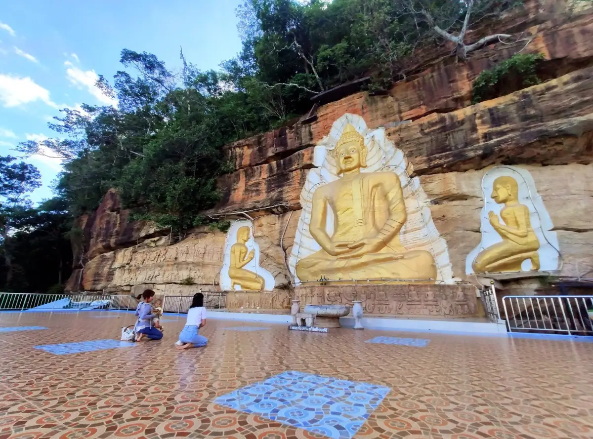
Wat Tham Phu Pha Khao in Mukdahan Province, locally known by the Phu Thai name Wat Tham Som, is a mountain forest monastery and meditation site built against the eastern cliff of Phu Khiao Mountain in Ban Pao Subdistrict, Nong Sung District. The temple faces east and overlooks Ban Pao, neighboring villages, agricultural land and the broad mountain landscape of Nong Sung. Its defining landmark is a large seated Buddha carved directly into the cliff and finished in a radiant golden tone. Four smaller Buddha images are arranged beside the main figure, with 2 on each side. The complex also includes buildings attached to the rock face, traditional-looking wooden monk residences, concrete walking routes, stairways, a ceremonial terrace, viewing platforms and forest areas suited to quiet contemplation.
Although Phu Khiao Mountain lies west of Ban Pao, the principal religious area occupies its eastern cliff. This orientation exposes the temple to the morning sun. At sunrise and during the early hours, light reaches the golden Buddha, rock surfaces and projecting buildings, creating a visual character very different from that of the afternoon. From the ceremonial terrace and viewpoint, visitors can look back across the lowlands of Ban Pao. The relationship between orientation, morning light, cliff and village landscape is therefore a central part of the temple’s identity.
Wat Tham Som is the traditional Phu Thai name used by residents of the area. Wat Tham Phu Pha Khao is now more common in tourism information and outside the community, but the older name remains present in oral history, signs and local directions. Both names refer to the same monastery. Wat Tham Phu Pha Khao describes the mountain and pale rock landscape, while Wat Tham Som preserves the linguistic and cultural identity of the Phu Thai communities of Nong Sung District.
Phu Khiao forms part of the sandstone mountain and plateau landscape of northeastern Thailand. Portions of the ridge are relatively level, while the sides descend through steep slopes and cliffs. Moist zones support denser evergreen vegetation, while areas receiving stronger sunlight contain mixed deciduous woodland. Differences in altitude, slope, water retention and orientation create a varied forest environment. The mountain becomes deep green during the rainy season, while the cool season brings stronger winds, lower temperatures and occasional mist around the ridge and cliffs.
Before the development of the cliff Buddha and larger buildings, the cave and rock shelters provided a secluded environment for monks. Distance from the settlement, natural shade and protection from weather made the mountain appropriate for meditation. In Buddhist practice, seclusion does not mean merely escaping other people. It means reducing physical and mental distractions so that thoughts, emotions and attachment can be observed more clearly. The mountain and forest therefore remain part of the practice environment rather than serving only as scenery.
The cliff-carved Buddha was developed through cooperation between the monastery and local residents. One event that strongly affected Buddhists at the time was the destruction of the ancient Bamiyan Buddhas in Afghanistan in March 2001. Those monumental figures had stood in their cliffs for more than a millennium before being destroyed. The event inspired the community to create a new cliff Buddha on Phu Khiao as a Buddhist memorial and as a reminder that teachings, ethical conduct and faith can continue even when historic religious objects are lost.
The Buddha at Wat Tham Phu Pha Khao is not a direct copy of the Bamiyan monuments. The concept of carving a sacred figure into a mountain was adapted to local rock, available space, craftsmanship and community faith. The work required examination of the cliff surface, selection of a stable position and adjustment of proportions so that the image could be seen from the terrace. Cliff carving is considerably more difficult than building a free-standing image on level ground because workers must manage height, equipment, material transport and safety within a confined area.
The main Buddha is carved into the rock and finished in gold, making it visible against the brown, grey and green tones of the mountain. Four smaller figures, 2 on either side, create a balanced composition. The arrangement transforms the natural cliff into a form of open-air shrine in which the mountain acts simultaneously as wall, background and supporting structure.
The group of figures encourages reflection on more than a single visual representation of the Buddha. The smaller images may lead visitors to consider the transmission of the Dhamma, the monastic community and the continuation of Buddhist teaching across generations. Even visitors unfamiliar with the individual postures can use the space to recollect non-violence, compassion, mindfulness and the effort to reduce greed, anger and delusion.
Additional carved panels and prepared areas around the buildings are intended to present Buddhist narratives. Development has proceeded gradually according to community donations, temple resources and annual merit-making events. Visitors may therefore encounter unfinished artwork, building material or temporarily restricted areas. This is common at rural monasteries where structures are created over many years rather than through a single large construction budget.
The cliff provides very little level space, preventing the complex from following the conventional layout of a lowland Thai monastery with separate ordination hall, viharn, sermon hall and courtyard. Several structures are attached to the rock and arranged on different levels. The roof or upper terrace of one building functions as a worship and ceremonial area facing the carved Buddha. This solution makes efficient use of limited ground and allows the cliff itself to define sacred space without enclosing every side with conventional walls.
The building projecting from the cliff serves both religious and viewing functions. Its structure must withstand the weight of visitors and materials as well as strong mountain winds. Everyone should remain behind barriers, avoid climbing parapets and prevent large groups from concentrating in one place. Elevated platforms provide impressive views, but safety must always take priority over photography.
Ban Pao and surrounding communities can be seen from the viewpoint. Roads, fields, gardens and clusters of houses reveal the connection between mountain and settlement. Phu Khiao provides forest, water, religious space and an important landscape reference for local people. Looking down from the monastery makes it clear that Ban Pao did not develop separately from the mountain but in relation to its environment and resources.
On clear days, visitors can see the flat-topped sandstone hills of Nong Sung and neighboring districts. After rain or during the beginning of the cool season, mist may drift through valleys and across the lowlands. Under suitable conditions, it can resemble a sea of mist from the terrace. This remains a natural phenomenon dependent on temperature, moisture and wind and cannot be guaranteed on a particular day.
Some monk residences are constructed from timber and positioned along the cliff. Their simple appearance resembles older rural buildings. Timber reduces structural weight and is practical where foundations and material transport are restricted. These buildings are private areas used for residence, study and meditation. Visitors must not enter, open doors or photograph interiors without permission.
The cliffside residences also express the restrained lifestyle of a forest monastery. Monks require only sufficient space for rest, essential belongings and meditation. Living beside forest and rock involves wind, darkness, changing weather and seclusion, all of which can support patience and awareness. Visitors can respect this environment by speaking quietly, limiting phone use and keeping entertainment outside the monastery.
The eastern approach from Ban Pao includes concrete road, steep walking sections and stairways. Because of the mountain’s gradient, vehicles can travel only part of the route according to road conditions, weather and current temple management. Recent visitors have used a lower parking area before completing the final steep section on foot. Some parts of the path receive limited shade, making drinking water and careful timing important.
Concrete steps have been added where needed to reduce slipping and define the route. Other sections remain sloping concrete paths adapted to the natural mountain. Shoes with secure grip are strongly preferable to smooth sandals, particularly in rain when water, moss, wet leaves and loose soil make the route slippery.
Older visitors, people with knee pain, heart disease or limited experience of steep walking should assess their condition before climbing. Resting is not a failure. Everyone should move at a steady pace without competition. Dizziness, chest pain, difficulty breathing or weakness are signs to stop in a safe area and request assistance. Families should remain together rather than allowing children or elderly members to walk alone.
A western approach connects with Nong Phok District in Roi Et Province and the Phra Maha Chedi Chai Mongkol area. Vehicles may reach higher portions of the mountain from this side, although the route still contains slopes, curves and surfaces affected by seasonal weather. Drivers should confirm current conditions and avoid unmarked forest roads or navigation shortcuts lacking reliable signs.
The mountain forms a natural connection between Mukdahan and Roi Et. Road distance can therefore be much greater than straight-line distance because vehicles must follow the contours of the ridge. Travelers starting in Mukdahan or Nong Sung will normally find the Ban Pao approach more practical. Those arriving from Nong Phok or Phra Maha Chedi Chai Mongkol may prefer the western route.
The lower parking area provides a place to prepare before the climb, with basic rest space and toilets. Facilities on the mountain are more limited than at an urban temple. Visitors should use the restroom, organise belongings and carry sufficient water before beginning. Food should be eaten only in permitted areas, and all packaging must be removed. Leaving food in the forest attracts animals and changes their natural behaviour.
The forest helps retain moisture, stabilise soil and provide habitat for birds, insects, reptiles and small mammals. Roads, buildings and paths must therefore be balanced with the preservation of existing trees. Visitors must not collect plants, orchids, rocks or natural objects. An action that appears harmless when performed once becomes destructive when repeated by many people.
Evergreen and mixed deciduous vegetation respond differently to season and moisture. Trees in humid areas retain foliage longer, while deciduous species reduce water loss by shedding leaves during the dry season. Dry leaves create a significant wildfire risk. Cigarette ends, matches, incense and hot materials must never be discarded in the forest. Candles and incense should be used only in designated areas and extinguished completely.
Forest recovery after fire or severe weather takes years. Young trees must survive dry seasons, wind and shallow mountain soil. Restoration requires not only planting but preventing further fire, protecting seedlings and controlling waste. Barriers, signs and newly planted zones must be respected.
Temperatures on the mountain are lower than on the plains, particularly in the morning, evening and cool season. Strong winds are common between November and February. A light jacket may be useful even when Ban Pao feels warm. Hats and loose belongings should be secured so that they are not blown beyond the barriers.
The rainy season creates lush scenery and a greater possibility of mist but also increases risk from slippery surfaces, falling branches, small landslides and reduced visibility. During heavy rain, thunderstorms or unusually strong wind, visitors should avoid cliff edges and should not continue toward exposed high areas. A photograph of mist is never worth unnecessary danger.
March through May is hot and sunny, particularly on the east-facing route. Climbing before 09:00 or after 15:00 is generally more comfortable. Water, breathable clothing and rest stops are essential. Anyone planning to see sunrise must first verify access because normal public visiting hours begin around 08:00, and steep travel in darkness is hazardous.
The most practical visiting periods are 08:00–10:30 and 14:30–17:00. Morning light reaches the east-facing Buddha and cliff, while the later afternoon is cooler. Visitors arriving late must allow enough time to descend before darkness and should not remain in the upper area beyond opening hours without permission.
The temple is generally open daily from 08:00 to 17:00 and does not charge an admission fee. Voluntary donations support paths, buildings, the cliff Buddha, electricity, toilets and monastic activities. Donations should be placed in authorised boxes or made through official channels. Ceremonies, Kathin events and construction may temporarily restrict certain areas.
The first principal zone is the entrance and lower parking area, where visitors should prepare water, footwear and essential belongings. The route then follows concrete paths and steps through forest and steep terrain toward the cliff buildings.
The second zone consists of buildings attached to the rock face. These provide rest areas, worship space and operational facilities. Because the structures occupy several levels, movement depends on stairs and connecting paths. Visitors should keep to the inner side, use handrails and avoid stopping for photographs in the middle of stairways.
The third zone is the golden cliff Buddha and its 4 accompanying figures. Worshippers may sit quietly, chant or recollect the Buddha’s qualities. Climbing the wall, touching painted surfaces, attaching gold leaf or placing objects on the base without permission can damage the work and create serious safety risks.
The fourth zone is the ceremonial terrace and viewpoint. It serves for chanting, meditation, community merit-making and landscape observation. Religious use takes priority. When ceremonies are taking place, visitors should remain quiet, avoid crossing through the centre and keep photographic equipment out of the congregation’s space.
The fifth zone contains wooden monk residences and private monastic areas. Even when visually interesting, they must be treated as residences rather than attractions. Visitors should not approach doors, photograph interiors or rest immediately outside the buildings. Anyone wishing to meet a monk should inquire in a public area.
The sixth zone consists of forest, ridge and nature-study areas. Certain paths may be reserved for monastic walking meditation or secluded practice. Only marked routes should be used. Dense vegetation can conceal cliff edges, making informal shortcuts especially dangerous.
People wishing to undertake formal meditation should contact the monastery in advance regarding accommodation, schedules, food and rules. Staying as a practitioner differs from sightseeing. Participants must observe moral discipline, dress appropriately, limit phone use and follow the monastery’s timetable.
Silence is one of the site’s most important resources. Loud conversation, speakers, drones and shouting across the cliff disturb monks, practitioners, wildlife and other visitors. Phones should remain silent. Necessary calls should be taken away from worship and meditation areas.
Clothing must be suitable for both a temple and a mountain climb. Shoulders should be covered, trousers or skirts should be of appropriate length, and fabric should permit safe movement. Closed shoes are preferable. Very long skirts can catch on steps, and clothing with offensive images or language is inappropriate.
Shoes must be removed where indicated. Feet should not be pointed toward Buddha images, and visitors must not stand on religious bases or pose disrespectfully. Non-Buddhist visitors are not required to perform every ritual. Quiet and respectful behaviour is sufficient.
Photography is acceptable when paths remain clear and visitors stay safely behind cliff barriers. Flash should be avoided during prayer. Monks and worshippers should not be photographed closely without permission. Commercial filming, large lighting systems, multiple tripods and drones require approval.
Children must remain under adult supervision. The complex contains slopes, stairways, high edges and barriers. Running, climbing railings and throwing objects from the viewpoint are dangerous. A family visit can instead focus on learning about Buddhism, forest ecology and mountain safety.
Organised groups should ascend in smaller units to prevent congestion. Coaches should coordinate parking and transfers in advance because the access road includes narrow, steep sections. Heavy traffic during holidays, Kathin and mist-viewing periods can obstruct both arriving and departing vehicles.
Getting There from Mukdahan city involves following Highway 12 or AH12 toward Khamcha-i and Nong Sung District, then entering Ban Pao Subdistrict. Depending on the starting point, the route may connect with the former Highway 299 and Rural Road 2370. Inside Ban Pao, small concrete roads and local signs lead toward Wat Tham Phu Pha Khao or Wat Tham Som. The final approach is steep and narrow.
From central Nong Sung, continue toward Ban Pao and ask for Wat Tham Som if necessary, because the local name remains widely understood. Navigation systems may display several routes. The correct eastern approach should pass through Ban Pao and have visible signs. Unmarked agricultural or dirt-road shortcuts should be avoided.
Ordinary vehicles can normally reach the lower parking area. Further access depends on signs, road condition and temple management. Underpowered vehicles, heavily loaded vehicles or vehicles with weak brakes should not attempt steep sections. Low gears should be used both uphill and downhill, and drivers should avoid continuous braking.
Motorcycles can use the road with caution, but gravel, water, moss and sand reduce traction. Helmets are essential, loads should remain balanced and heavy rain should be avoided. Inexperienced riders should park safely and complete the final section on foot.
The western road connects from Nong Phok District and Phra Maha Chedi Chai Mongkol. This may reduce travel for visitors arriving from Roi Et, but ridge roads can be affected by rain and repair work. Current local information should be checked before departure.
A half-day itinerary should begin in the morning and allow 2–3 hours for the climb, carved Buddha, cliff buildings and viewpoint. After descending, visitors can eat in Ban Pao or Nong Sung and continue to Ban Phu Cultural Village or the Isan Literary Botanical Garden.
A full-day route may add Pha Kiew Lom, Wat Tham Champa Kantasilawat and Phra Maha Chedi Chai Mongkol. Planning must follow road direction rather than straight-line distance because mountain routes often require significant detours.
Ban Phu and nearby Phu Thai communities offer opportunities to learn about language, textiles, clothing, food and agricultural life. Visiting the community demonstrates that Wat Tham Som developed through the support of people living around the mountain. Purchasing local products allows tourism income to reach households directly.
The Isan Literary Botanical Garden presents plants associated with regional literature and northeastern ecosystems. Combining it with Wat Tham Phu Pha Khao allows travelers to compare managed botanical study with natural mountain forest. The garden’s operating schedule should be checked separately.
Phra Maha Chedi Chai Mongkol stands on the Roi Et side of the same broader mountain landscape. Visiting both sites illustrates different uses of elevated terrain. Wat Tham Phu Pha Khao centres on cave, cliff and carved Buddha, while Phra Maha Chedi Chai Mongkol is organised around a monumental chedi and formally planned religious complex.
Restaurants near the monastery are limited. Most options are found in Ban Pao, Nong Sung, the wind-farm route and Nikhom Kham Soi. Local choices include Isan food, beef, cooked-to-order dishes, coffee and drinks. Groups should telephone ahead because rural businesses may adjust their hours or close earlier than urban restaurants.
Rai Kanghan Lom Mukdahan offers food and drinks along the mountain route. Nong Sung Beef Steak Restaurant reflects the district’s cattle-farming reputation, while Im Pung Kang provides another option in the Nong Sung area. Travelers continuing toward Nikhom Kham Soi can use Good View Cafe or Thai House-Isaan Restaurant.
Accommodation directly beside the mountain is limited. Thai House-Isaan Guesthouse and Noi Khan Tae Resort provide options along connecting rural routes. Travelers wanting larger hotels can stay in Mukdahan city at Bird Day Boutique Hotel, Hotel de Ladda or Riverfront Hotel Mukdahan and depart early for Nong Sung.
Anyone wishing to stay inside the monastery for practice must obtain permission in advance. Temple accommodation is not a commercial service. Guests must follow the schedule, observe moral rules, avoid alcohol and entertainment and assist with cleanliness.
The temple is valuable to students of Buddhist art because the cliff becomes the material and support of the main image. The Buddha cannot be separated from the mountain in the manner of a free-standing statue. Proportions, golden color and the 4 smaller figures were adapted to an irregular natural surface.
Architecture enthusiasts can examine how structures project from and attach to a confined cliff. Foundations, floors, columns and circulation must follow actual rock formations rather than a standard lowland plan. The buildings represent a practical compromise between use, safety, available funding and terrain.
Nature enthusiasts can observe how vegetation changes with elevation, moisture and season. Study should be non-destructive. Plants must not be collected, and wildlife must not be approached or fed. Snakes, insects and other animals should be given space to move away naturally.
For meditation practitioners, the steep approach can represent perseverance but should never become an excuse to injure the body. Practice begins with recognising actual physical conditions. Fatigue should be known as fatigue, and resting can be done mindfully. Wind, silence and wide views may reveal thoughts normally hidden beneath daily activity.
The cliff Buddha represents continuity within change. Rock, paint and architecture are exposed to sun, rain, wind and erosion. Even stone religious objects are impermanent. Conservation does not make them eternal; it slows deterioration so that meaning can be passed to future generations.
The destruction of the Bamiyan Buddhas, which influenced the local project, demonstrates the vulnerability of religious heritage. Monuments can disappear through war, hatred, disaster and neglect. The Ban Pao community responded not by creating further conflict but by cooperating to build a new Buddhist image and meditation place on its own mountain.
Donations should be made through official temple channels. Funds may support paths, barriers, paint conservation, forest protection, waste management and toilets. Support should improve safety and religious use without introducing structures that unnecessarily dominate the landscape.
The current abbot’s name has not been confirmed through a recent publicly available official record. Route, community and group-visit information can be coordinated with Ban Pao Subdistrict Municipality, which publishes information about the temple and surrounding community. Avoiding an unverified personal name prevents outdated information from being repeated after monastic responsibilities change.
Weather should be checked before departure, particularly during the rainy season. Heavy rain and storm warnings are valid reasons to postpone the climb and visit a lowland community attraction instead. Changing plans under unsafe conditions respects the mountain and reduces risk to local responders.
Solo travelers should inform someone of their route and expected return time. Phones should be charged and emergency numbers saved. Signal coverage may vary on rural and mountain sections. Small groups of 2–3 people are safer than leaving the marked path alone.
Wat Tham Phu Pha Khao should not be treated as a rapid photographic stop. The climb, forest, wind, silence and time spent before the Buddha are all part of the experience. Allowing 2–3 hours creates a safer pace and provides space for genuine observation.
The temple combines Phu Thai language, community cooperation, cliff art, adaptive architecture, wooden residences, viewpoints, evergreen forest, mixed deciduous woodland and meditation. Removing any one dimension would reduce the meaning of the place. Its protection must therefore consider religion, architecture, nature and community life together.
Standing before the Buddha and looking down toward Ban Pao reveals the relationship between mountain and plain. The monastery is secluded but still faces the community. It is neither completely hidden in inaccessible forest nor absorbed into the noise of the village. This position creates a balance between retreat and continuing connection with local people.
Wat Tham Phu Pha Khao is suitable for pilgrims, Buddhist-art enthusiasts, mountain travelers, students of Phu Thai culture and people seeking a quiet environment. The most meaningful visit involves physical preparation, respect for the path, protection of silence and leaving no harmful trace. Visitors should take home memories and reflection rather than rocks, plants or objects from the mountain.
| Name | Wat Tham Phu Pha Khao |
| Local Name | Wat Tham Som, a traditional Phu Thai name used by local communities |
| Type | Mountain forest monastery, cliff-Buddha shrine and meditation site |
| Location | Phu Khiao Mountain, Ban Pao Subdistrict, Nong Sung District, Mukdahan Province, Thailand |
| Address | Ban Pao Subdistrict, Nong Sung District, Mukdahan 49160, Thailand |
| Map Reference | Plus Code C8CF+XPC, Ban Pao, Nong Sung, Mukdahan |
| Landscape | An east-facing cliff on Phu Khiao Mountain with steep paths, ridge forest, evergreen and mixed deciduous vegetation and broad views across Ban Pao |
| Temple Orientation | The principal religious area faces east, receiving morning light and overlooking the Ban Pao communities |
| Highlights | Golden cliff-carved Buddha, 4 smaller Buddha figures, buildings attached to the cliff, wooden monk residences, viewpoint, mountain path, forest and seasonal mist |
| Cliff Buddha | A large Buddha carved into the rock and finished in gold, accompanied by 2 smaller Buddha figures on each side |
| Artistic Inspiration | Created through cooperation between monks and the local community after the destruction of the Bamiyan Buddhas in Afghanistan in 2001 |
| Site Care | Maintained by the resident monastic community and Ban Pao residents; the current abbot’s name has not been confirmed in a recent public government record |
| Main Areas / Zones | 1. Entrance and lower parking 2. Concrete mountain path and stairways 3. Cliffside building complex 4. Golden cliff Buddha and accompanying figures 5. Ceremonial terrace and viewpoint 6. Wooden monk residences and restricted monastic zone 7. Meditation and walking-practice areas 8. Forest, ridge and nature-study areas |
| Current Status | Active monastery and meditation site; some structures or artwork may undergo continuing construction or improvement |
| Open Days | Daily |
| Opening Hours | 08:00 – 17:00 |
| Admission Fee | Free admission; voluntary donations for maintenance of the monastery, paths and cliff Buddha are welcome |
| Facilities | Lower parking, toilets, rest pavilion, concrete walking path, steps, barriers, worship terrace and viewpoint |
| Eastern Ban Pao Route | Follow Highway 12 toward Nong Sung and enter Ban Pao. Vehicles can use part of the mountain road before visitors continue on foot along steep concrete paths and steps |
| Western Route | Approach through Nong Phok District, Roi Et, and the Phra Maha Chedi Chai Mongkol area. Vehicle access may reach higher sections, but current road conditions should be checked |
| Recommended Visiting Time | 08:00–10:30 or 14:30–17:00. The cool season is windy, while the rainy season may bring mist and slippery paths |
| Recommended Visit Duration | Approximately 2–3 hours, including the climb, worship area and viewpoint |
| Local Information Contact | Ban Pao Subdistrict Municipality, Tel. 042-642-589, 042-642-577 |
| Visitor Etiquette | Dress respectfully, use secure footwear, remain quiet, avoid climbing cliffs or barriers, do not touch Buddha images, respect restricted monastic areas, obtain permission before drone use and leave plants and rocks in place |
| Nearby Tourist Attractions | 1. Ban Phu Cultural Community, approximately 4 km by road 2. Pha Kiew Lom, approximately 6 km by road 3. Isan Literary Botanical Garden, approximately 8 km by road 4. Wat Tham Champa Kantasilawat, approximately 10 km by road 5. Phra Maha Chedi Chai Mongkol, approximately 12 km via the western route 6. Wat Banphot Khiri or Wat Phu Chok Ko, approximately 32 km by road |
| Nearby Restaurants | 1. Rai Kanghan Lom Mukdahan, approximately 14 km, Tel. 085-853-9158 2. Nong Sung Beef Steak Restaurant, approximately 18 km, Tel. 094-894-5048 3. Im Pung Kang Restaurant, approximately 18 km, Tel. 088-964-9716 4. Good View Cafe, approximately 30 km, Tel. 064-325-5289 5. Thai House-Isaan Restaurant, approximately 31 km, Tel. 090-843-2970 |
| Nearby Accommodations | 1. Thai House-Isaan Guesthouse, approximately 31 km, Tel. 090-843-2970 2. Noi Khan Tae Resort, approximately 34 km, Tel. 085-144-1680, 081-071-2796 3. Bird Day Boutique Hotel, approximately 62 km, Tel. 093-469-5588, 042-615-007 4. Hotel de Ladda, approximately 64 km, Tel. 042-611-499, 042-611-497 5. Riverfront Hotel Mukdahan, approximately 64 km, Tel. 042-612-948-9, 081-703-1705 |
Frequently Asked Questions (FAQ)
Q: Are Wat Tham Phu Pha Khao and Wat Tham Som the same place?
A: Yes. Wat Tham Phu Pha Khao is the name commonly used in tourism information, while Wat Tham Som is the traditional Phu Thai name used by local communities.
Q: Where is Wat Tham Phu Pha Khao located?
A: The monastery is on the eastern cliff of Phu Khiao Mountain in Ban Pao Subdistrict, Nong Sung District, Mukdahan Province. The principal area faces east and overlooks Ban Pao.
Q: What are the opening hours and admission fee?
A: The temple is open daily from 08:00 to 17:00. Admission is free, and visitors may make voluntary donations toward maintenance of the paths, buildings and cliff Buddha.
Q: Can vehicles reach the upper temple?
A: From Ban Pao, vehicles can travel part of the mountain road before visitors continue on foot along steep concrete paths and steps. The western route from Nong Phok may provide higher vehicle access, but current road conditions should be confirmed.
Q: What is the main highlight of the temple?
A: The principal highlight is a large golden Buddha carved directly into the cliff, accompanied by 2 smaller Buddha figures on each side. The cliff buildings, wooden monk residences, viewpoint and mountain forest are also important.
Q: Can visitors see a sea of mist?
A: Mist may form after rain and during the beginning of the cool season, but it depends on daily temperature, moisture and wind and cannot be guaranteed.
Q: Is the temple suitable for older travelers?
A: Older travelers can visit when their health and the route are assessed carefully. The climb is steep and requires walking. Assistance, regular rest and secure footwear are recommended.
Q: How much time should travelers allow for a visit?
A: Allow approximately 2–3 hours for the mountain approach, cliff Buddha, buildings, worship and viewpoint without rushing.
 Category: ●Places of Worship
 Group: ●Temple
Last Update : 2 MonthAgo
 Last Update : 2 MonthAgo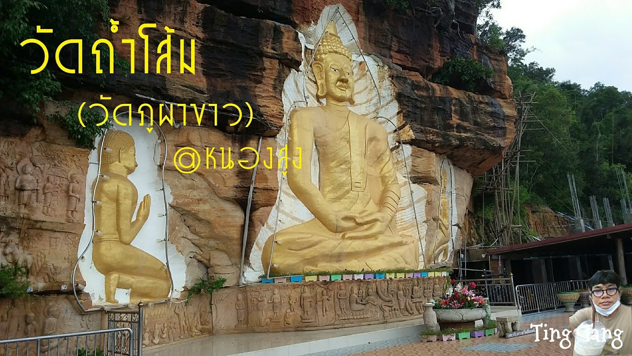
 Click to Access the Navigation Map GPS
Wat Tham Phu Pha Khao (Wat Tham Som) Map
Recommend

 Art, Culture and Heritage
 Historical Sites and Monuments(2)
 Landmarks and Memorials(3)
 Art, Craft Centres, Tradition(2)
 Museums(1)
Temple(17)
Museums(1)
Temple(17)
 Other Sacred Sites(3)
 Suburban Living
 Village, Community(4)
 Local Market(2)
 Nature and Wildlife
 National Parks and Marine Reserves(4)
 Mountain (Doi)(5)
 Dam, Reservoir, Lake(3)
 Waterfalls(5)
 Caves(2)
 River, Canal(2)
 Bays and Beaches(1)
 Other natural attractions(1)
 Entertainment and Agricultural
 Farms, Parks and Ecotourism(1)


