
lovethailand home >Northeastern Travel Attractions >Kalasin Travel Attractions >Muang Kalasin >Lam Pao > Lam Pao Dam
TL;DR: Lam Pao Dam is located at Lam Pao Reservoir area, Kalasin Province, covering several districts including Mueang Kalasin, Yang Talat, Nong Kung Si, and Sahatsakhan, open Daily, hours 08.30 – 16.30.

Lam Pao Dam
Open Days: Daily
Opening Hours: 08.30 – 16.30
Lam Pao Dam in Kalasin Province is one of the most important large earthen dams in northeastern Thailand. Built across the Lam Pao River and Huai Yang, the dam serves several essential purposes: storing water, reducing flood impacts, supporting agriculture, sustaining inland fisheries, and providing a scenic freshwater recreation area for local communities and travelers. Today, Lam Pao Dam is widely known not only as an irrigation project, but also as a major leisure destination in Kalasin, especially around Hat Dok Ket, the popular freshwater beach often described as the “Isan Sea”.
Lam Pao Dam is more than a sightseeing spot. It is a major water-management structure that influences the daily life, agriculture, fisheries, and local economy of several districts around the reservoir, including Mueang Kalasin, Yang Talat, Nong Kung Si, and Sahatsakhan. The dam was built to block the Lam Pao River and Huai Yang near Ban Nong Song Hong in Lam Pao Subdistrict, Mueang Kalasin District. The construction created a large reservoir north of the dam. In its early formation, the reservoir had the character of twin water bodies, so a connecting channel was dug to link them and improve water management.
The history of Lam Pao Dam began with the need to control flooding and address water shortages in agricultural areas of Kalasin and nearby provinces. Construction started in 1963 and was completed in 1968. Since then, the dam has become one of the major irrigation projects that transformed the landscape, economy, and way of life along the Lam Pao basin. What was once a natural river system and rural farmland became a vast reservoir that stores water for dry-season use, supports irrigation, and helps reduce flood pressure during the rainy season.
The dam itself is an earthen dam standing about 33 metres high from the riverbed. Its crest is approximately 7.8 kilometres long and about 8 metres wide. Because of its long earth embankment and open reservoir views, the area is suitable for scenic drives, photography, and relaxed sightseeing. In the early morning and late afternoon, the light reflecting on the water gives the reservoir a calm and spacious atmosphere. Travelers often visit the dam crest, nearby viewpoints, Hat Dok Ket, and the reservoir-side food areas to enjoy the landscape and local lifestyle.
There are two commonly cited figures for the reservoir capacity. General tourism information often states that Lam Pao Reservoir can store around 1,430 million cubic metres of water, while current water-management reports use a reservoir capacity figure of about 1,980 million cubic metres at the normal storage level. Both figures appear in different contexts. The 1,430-million-cubic-metre figure is often found in tourism descriptions and older general references, while the 1,980-million-cubic-metre figure is used in current operational water-management reporting.
The primary functions of Lam Pao Dam are water storage, irrigation supply, flood mitigation, and water-security support for the surrounding region. The reservoir supplies water to large agricultural areas in Kalasin, especially rice fields and seasonal crops that depend on irrigation during crucial growing periods. It is also an important inland fishery, supporting local fishermen and reservoir-side communities. This makes Lam Pao Dam both an engineering project and a living economic landscape where agriculture, fisheries, food culture, and tourism are closely connected.
For most travelers, the most recognizable recreational area at Lam Pao Dam is Hat Dok Ket. This freshwater beach sits along the reservoir and has become one of Kalasin’s best-known leisure spots. It features a wide waterside area where visitors can sit, eat, relax, take photos, and enjoy the breeze from the reservoir. During hot-season weekends, long holidays, and Songkran, the atmosphere becomes especially lively as families and groups of friends come to swim, dine, and spend time by the water.
The name Hat Dok Ket is linked to local vegetation, especially the pandanus-like kara-ket plants associated with the area. The name was shortened into the easier local name “Dok Ket”, which eventually became the name of the popular waterfront destination. Although it is not a real sea, the combination of sand, open water, waterside seating, and a relaxed holiday mood gives it the feeling of a beach. This is why many people refer to the area as a freshwater sea or the Isan Sea of Kalasin.
Activities around Lam Pao Dam and Hat Dok Ket vary by season and local services. Visitors can enjoy the reservoir view, sit under shaded areas, eat local food, take photographs, rent inner tubes or life jackets in designated areas, join raft dining services, or take short boat trips where available. Safety remains important. Travelers who enter the water should stay in supervised areas, use life jackets when needed, avoid deep or fast-flowing water, follow warning signs, and never leave children unattended near the water.
Another major highlight connected with Lam Pao Reservoir is Thepsuda Bridge. This reinforced-concrete bridge crosses the reservoir and connects Sahatsakhan District with Nong Kung Si District. With a length of about 2.04 kilometres, it is widely recognized as one of Thailand’s longest freshwater bridges. Driving across the bridge offers broad views over the reservoir, making it a memorable scenic route. It is also a practical link to attractions in Sahatsakhan, including Sirindhorn Museum, Wat Phuttha Nimit Phu Khao, Phra That Yakhu, and other cultural sites in Kalasin.
The communities around Lam Pao Dam also give the destination a strong local character. Visitors will find freshwater fish dishes, grilled tilapia, grilled prawns, som tam, spicy salads, and Isan-style meals served at reservoir-side restaurants and raft dining areas. The local food scene reflects the relationship between the reservoir and the people who live around it. Eating fish or prawns while looking out over the water is one of the most enjoyable parts of visiting Lam Pao Dam.
For travelers interested in geography and water systems, Lam Pao Dam is a clear example of how a natural river basin can be reshaped into a large reservoir for public benefit. The Lam Pao River is part of the broader water network of northeastern Thailand, and the dam helps store water, regulate flows, and support downstream areas. Its role is particularly important during seasonal changes, when the region may face either heavy rainfall or dry conditions. This makes Lam Pao Dam an important case study in water management, rural development, and regional resilience.
The reservoir also has environmental value as a large freshwater ecosystem. It supports fish, aquatic life, birds, and seasonal wetland areas. Responsible tourism is therefore essential. Visitors should avoid throwing rubbish into the water, disturbing wildlife, leaving plastic waste behind, or using the reservoir carelessly. Keeping the area clean helps preserve both the tourism value of Lam Pao Dam and the quality of water resources used by nearby communities.
The best time to visit Lam Pao Dam depends on the travel style. For a lively beach-like atmosphere, the hot season and long holiday periods are the most energetic, especially around Hat Dok Ket. For quiet sightseeing, photography, and scenic drives, weekdays in the early morning or late afternoon are more comfortable. During the rainy season and the transition into the cool season, the surrounding landscape becomes greener and the reservoir often looks fuller, but travelers should check weather conditions and water-management announcements before visiting.
Getting There from Kalasin city is most convenient by private car or rental vehicle. Take Highway 213 on the Kalasin – Maha Sarakham route. Around kilometre markers 33 – 34, turn onto the paved road toward Lam Pao Dam and continue for about 20 – 26 kilometres, depending on the specific area you plan to visit. Travelers heading to Hat Dok Ket should follow the route toward Lam Khlong Subdistrict in Mueang Kalasin District, while those going to Thepsuda Bridge and Sahatsakhan can continue toward Laem Non Wiset and the Sahatsakhan tourism route. Because attractions around the reservoir are spread out, having your own vehicle is the most practical option.
Travelers using public transport can first arrive in Kalasin city by interprovincial bus or van, then continue to the dam by local transport, hired vehicle, or private transfer. Planning ahead is recommended, especially for visitors who want to cover several places in one day, such as Lam Pao Dam, Hat Dok Ket, Thepsuda Bridge, Sirindhorn Museum, and Wat Phuttha Nimit Phu Khao. Starting early gives enough time for sightseeing, lunch by the reservoir, and a safe return before evening.
Lam Pao Dam is suitable for families, groups of friends, nature travelers, photographers, and visitors interested in local engineering and water-management landscapes. Its strength lies in the variety of experiences it offers in one area: learning about a major irrigation project, enjoying reservoir scenery, eating local freshwater dishes, relaxing by the water, and connecting onward to Kalasin’s cultural and archaeological attractions.
A one-day trip can begin in Kalasin city in the morning, continue to the dam crest and reservoir viewpoints, then stop at Hat Dok Ket for lunch and leisure time. In the afternoon, travelers can drive to Thepsuda Bridge for panoramic reservoir views and then visit Sirindhorn Museum or Wat Phuttha Nimit Phu Khao in Sahatsakhan. With 2 days and 1 night, the route can be expanded to include Phra That Yakhu, Mueang Fa Daet Song Yang, Wat Sakkawan, and more local food experiences around the reservoir.
Useful items to bring include a hat, sunglasses, sunscreen, sandals or water-friendly shoes, spare clothes, a waterproof phone pouch, and some cash for small local shops or seasonal services. During festivals, visitors should allow extra travel time because Hat Dok Ket and the main waterside areas may become crowded. For photography, early morning and late afternoon provide softer light and more attractive reservoir views than the strong midday sun.
Lam Pao Dam ultimately represents the close relationship between water, agriculture, local communities, and tourism in Kalasin Province. What began as a major irrigation and flood-mitigation project has grown into a beloved freshwater recreation area with Hat Dok Ket, Thepsuda Bridge, local restaurants, fishing communities, and scenic routes around the reservoir. A visit to Lam Pao Dam is therefore not only about seeing a dam, but also about understanding a large freshwater landscape that continues to support people, nature, and the local economy of northeastern Thailand.
| Name | Lam Pao Dam |
| Location | Lam Pao Reservoir area, Kalasin Province, covering several districts including Mueang Kalasin, Yang Talat, Nong Kung Si, and Sahatsakhan |
| Address | Main tourism areas around Lam Pao / Lam Khlong Subdistrict, Mueang Kalasin District, and connected areas in Yang Talat District, Kalasin Province |
| Coordinates | Approx. 16.73, 103.54 |
| Highlights | Large earthen dam, wide reservoir, Hat Dok Ket, Thepsuda Bridge, scenic viewpoints, and reservoir-side fish and prawn restaurants |
| History | Construction began in 1963 and was completed in 1968 to store water, reduce flood impacts, and support agriculture in Kalasin Province |
| Name Origin | Named after the Lam Pao River, one of the main waterways blocked by the dam together with Huai Yang |
| Distinctive Features | Earthen dam about 33 metres high, with a crest about 7.8 kilometres long and about 8 metres wide, forming a large reservoir with several recreation zones |
| Reservoir Capacity | General tourism references often cite about 1,430 million cubic metres, while current water-management reporting uses about 1,980 million cubic metres at normal storage level |
| Travel Information | From Kalasin city, take Highway 213 toward Maha Sarakham. Around kilometre markers 33 – 34, turn onto the paved road toward Lam Pao Dam and continue about 20 – 26 km. Highway 2416 can also be used to access the dam area |
| Current Status | Open as a tourist attraction and still operating as a major irrigation dam in Kalasin Province |
| Open Days | Daily |
| Opening Hours | 08.30 – 16.30 |
| Fees | No admission fee |
| Facilities | Road access, viewpoints, parking areas in some zones, reservoir-side restaurants, seasonal local shops, inner tube and life jacket rentals around Hat Dok Ket, and raft dining services in selected areas |
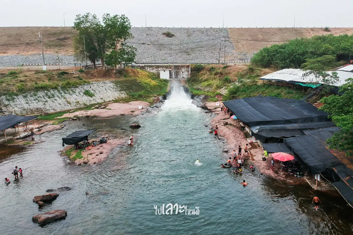
| Main Areas / Zones | 1. Dam crest and Lam Pao Dam viewpoints 2. Hat Dok Ket 3. Water diversion and seasonal swimming areas 4. Thepsuda Bridge and Laem Non Wiset 5. Fishing communities and reservoir-side restaurants |
| Caretaker | Lam Pao Operation and Maintenance Project, Regional Irrigation Office 6, Royal Irrigation Department; Project Director: Mr. Samruay Inphithak |
| Main Contact Number | 043-813-024 |
| Official Website / Official Page | Lam Pao Operation and Maintenance Project, Regional Irrigation Office 6 |
| Nearby Tourist Attractions | 1. Hat Dok Ket, about 1 km 2. Thepsuda Bridge, about 18 km 3. Sirindhorn Museum, about 28 km 4. Wat Phuttha Nimit Phu Khao, about 30 km 5. Phra That Yakhu, Mueang Fa Daet Song Yang, about 35 km 6. Wat Sakkawan, Phu Kum Khao, about 28 km |
| Nearby Restaurants | 1. Jae Oi Grilled Fish And Prawns, Hat Dok Ket & Lam Pao Dam, about 1 km, Tel. 088-552-4862, 083-084-3302 2. Pui Grilled Fish And Prawns, Hat Dok Ket & Lam Pao Dam, about 1 km, Tel. 061-064-9097 3. Dok Ket Seafood, about 1 km 4. Pho Noi Soi Derm, about 2 km 5. Phae Waranphon, Thepsuda Bridge, about 18 km, Tel. 082-110-7977, 081-369-0522, 081-054-2724 6. Baan Choeng Khao Restaurant, about 24 km, Tel. 080-734-8715 |
| Nearby Accommodations | 1. Phu Aree Resort, about 2 km, Tel. 095-178-0562 2. Rich Lam Pao Resort, about 18 km, Tel. 091-575-4507 3. Baan Suan Khwam Hak Resort, about 23 km, Tel. 082-117-9083 4. Sukwan Boutique Home, about 26 km, Tel. 063-727-3729 5. Iyara Resort Kalasin, about 27 km, Tel. 098-661-4929 6. Phupeng House Resort, about 30 km, Tel. 087-948-6967 |
Frequently Asked Questions (FAQ)
Q: Where is Lam Pao Dam located?
A: Lam Pao Dam is located in Kalasin Province, northeastern Thailand. Its reservoir covers several districts, with main tourist areas around Mueang Kalasin, Yang Talat, Nong Kung Si, and Sahatsakhan.
Q: What is Lam Pao Dam known for?
A: It is known for its large earthen dam, wide freshwater reservoir, Hat Dok Ket, Thepsuda Bridge, scenic viewpoints, and reservoir-side local food.
Q: What is Hat Dok Ket?
A: Hat Dok Ket is a popular freshwater beach on Lam Pao Reservoir where visitors can relax, eat local food, enjoy the water, and experience a beach-like atmosphere in northeastern Thailand.
Q: Is there an admission fee for Lam Pao Dam?
A: There is no admission fee. However, private services such as tube rental, life jacket rental, raft dining, or local activities may have separate charges.
Q: When is the best time to visit Lam Pao Dam?
A: The dam can be visited year-round. The hot season and long holidays are lively around Hat Dok Ket, while weekdays, early mornings, and late afternoons are better for quieter sightseeing and photography.
Q: How can travelers get to Lam Pao Dam from Kalasin city?
A: Take Highway 213 toward Maha Sarakham, turn toward Lam Pao Dam around kilometre markers 33 – 34, and continue for about 20 – 26 km depending on the destination area.
Q: Is Lam Pao Dam suitable for families?
A: Yes. It is suitable for families because it has scenic areas, local restaurants, waterside relaxation spots, and light activities. Children should always be supervised near the water and wear life jackets when swimming.
Q: What attractions can be visited together with Lam Pao Dam?
A: Travelers can combine Lam Pao Dam with Thepsuda Bridge, Sirindhorn Museum, Wat Phuttha Nimit Phu Khao, Phra That Yakhu, and Wat Sakkawan at Phu Kum Khao.
 Category: ●Nature and Wildlife
 Group: ●Dam, Reservoir, Lake
Last Update : 2 MonthAgo
 Last Update : 2 MonthAgo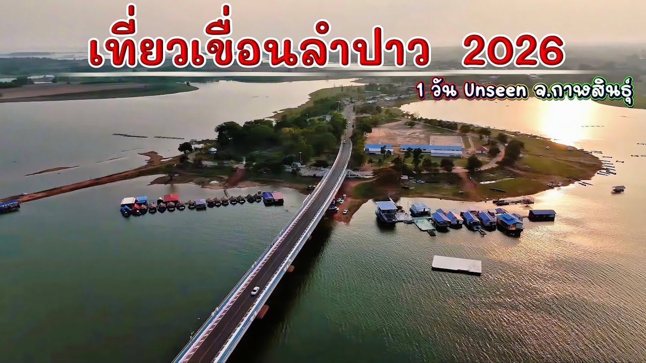
 Click to Access the Navigation Map GPS
 Art, Culture and Heritage
 Historical Sites and Monuments(2)
 Landmarks and Memorials(3)
 Art, Craft Centres, Tradition(4)
 Museums(3)
 Art Gallery(1)
 Educational Places
 Educational Gardens, Farm(1)
 Places of Worship
 Temple(21)
 Other Sacred Sites(6)
 Suburban Living
 Village, Community(3)
 National Parks and Marine Reserves(3)
 Mountain (Doi)(2)
Dam, Reservoir, Lake(5)
Mountain (Doi)(2)
Dam, Reservoir, Lake(5)
 Waterfalls(4)
 Caves(2)
 River, Canal(3)
 Bays and Beaches(1)
 Other natural attractions(2)
 Entertainment and Agricultural
 Animal camps and shows(1)
 Farms, Parks and Ecotourism(2)


