
lovethailand home >Northeastern Travel Attractions >Buri Ram Travel Attractions >Ban Kruat >Prasat > Chong Obok
TL;DR: Chong Obok is located at Ban Sai Tho 1, Prasat Subdistrict, Ban Kruat District, Buriram Province, open Access is subject to official permission and local security conditions, hours Access is subject to official permission and local security conditions.

Chong Obok
Open Days: Access is subject to official permission and local security conditions
Opening Hours: Access is subject to official permission and local security conditions
Chong Obok in Buriram Province is a Thai-Cambodian border pass in Prasat Subdistrict, Ban Kruat District. It is known as a natural frontier route, a border viewpoint, a place connected with local history, and a meaningful learning site along the Phanom Dong Rak mountain range. The name comes from Khmer: “O” refers to a stream, while “Bok” describes water flowing strongly from the mountain down to lower ground. Today, visitors must follow instructions from local authorities because the area is part of a sensitive border zone.
Chong Obok in Buriram Province is one of the most meaningful border locations in the lower northeastern region of Thailand. It is not only a viewpoint or a rural destination on the map, but also a place where geography, language, history, water systems, local communities, and border memory come together. The word “chong” in Thai often refers to a mountain pass or a natural opening through a range of hills. The word “Obok” has Khmer roots. “O” means a stream or creek, while “Bok” describes the action of water flowing down strongly from a mountain to lower land in separate currents. The name therefore reflects the physical character of the area: a pass where streams and mountain runoff move through the landscape.
Chong Obok is located around Ban Sai Tho 1 in Prasat Subdistrict, Ban Kruat District, Buriram Province, close to the Thai-Cambodian border. The surrounding landscape belongs to the edge of the Phanom Dong Rak range, a long mountain system that forms part of the natural frontier between Thailand and Cambodia. This setting explains why Chong Obok has been important for generations. Before modern borders were defined by official maps, natural mountain passes such as this served as practical routes for local people. They connected villages, forests, fields, water sources, and communities on both sides of the range.
For foreign travelers, Chong Obok offers a different way to understand Buriram. The province is widely known for Phanom Rung Historical Park, Prasat Muang Tam, football culture, and Khmer stone sanctuaries. However, Ban Kruat District reveals another side of Buriram: a border district with ancient kilns, metallurgical sites, sandstone resources, community reservoirs, rural settlements, and frontier history. Visiting Chong Obok helps travelers see that Buriram’s cultural landscape extends far beyond its famous monuments. It includes border routes, local waterways, hill passes, and the everyday lives of people who have lived near the frontier for generations.
In the past, Chong Obok functioned as a contact route between Thai and Cambodian communities. People living along the border did not see the landscape only as a political boundary. For them, forests, streams, mountain paths, and passes were part of daily life. They were used for travel, small-scale exchange, family contact, and access to natural resources. Local culture in this part of Thailand carries strong influences from Khmer-speaking communities, as well as other ethnic and linguistic groups in the lower Isan region. This is why the name Chong Obok itself is important: it preserves a linguistic trace of the cultural relationship between people and place.
The physical landscape of Chong Obok explains the meaning of its name. Water descending from the mountain range, natural channels, slopes, and seasonal runoff are all part of the local environment. In many Thai and Khmer-speaking communities, place names were often formed from direct observation of geography. A stream, a hill, a rocky terrace, a pass, or a large tree could become a permanent name that later generations continued to use. Chong Obok is one of those names. It is not just a label; it is a compact description of the terrain.
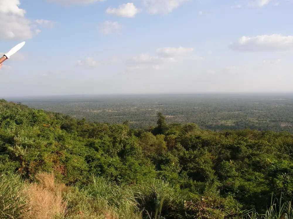
Today, Chong Obok has been developed as a border viewpoint and a place for learning about local history. From certain viewpoints, visitors can sense the openness of the frontier landscape and the connection between the Thai side and the Cambodian side. The atmosphere is quieter and more serious than that of a typical tourist attraction. It is suitable for travelers who are interested in history, geography, community identity, and the role of border areas in shaping local life. This is not a commercial entertainment destination. It is a place that should be visited with awareness and respect.
The present-day significance of Chong Obok is also connected with border security and national memory. Ban Kruat District has been involved in several periods of Thai-Cambodian border history. The surrounding mountains, passes, and ridges have been part of modern security operations and military memory. At Chong Obok, a memorial honoring Lieutenant Colonel Theeradej Phetbut was opened to commemorate sacrifice and duty in protecting Thai sovereignty. For visitors, this gives the site an educational dimension. It is a place to remember that border landscapes are not only scenic, but also deeply connected with the people who have served and lived there.
The memorial at Chong Obok turns the area into an outdoor history classroom. It allows younger generations, students, local residents, and travelers to understand the importance of the border in a more tangible way. Standing in such a place, visitors can see how geography, state boundaries, and human responsibility overlap. The site is therefore especially meaningful for those interested in military history, local studies, Thai-Cambodian border relations, and the cultural geography of the lower northeast.
Another important nearby feature is Obok Reservoir, also known as Sai Tri Phatthana 1 Reservoir. This reservoir is connected with the runoff system from the Phanom Dong Rak mountain area around Chong Obok. It supports local water use for households and agriculture in nearby communities. The relationship between the pass and the reservoir shows that Chong Obok is not only a route or a viewpoint. It is also part of a water landscape that helps sustain local life. Mountain water, streams, seasonal flow, and agricultural communities are all part of the same local system.
For travelers who want to understand the broader context of Ban Kruat, Chong Obok can be combined with archaeological and cultural sites in the district. Ban Kruat is known for ancient kiln sites, old metallurgical traces, Khmer-style sanctuaries, and stone resources. Sites such as Prasat Thong, also known as Prasat Ta Jia, Prasat Thamo, ancient kiln areas, and laterite or sandstone remains reveal the historical depth of the district. These places show that Ban Kruat was not an isolated border area. It was part of a wider cultural and technological landscape in the Khmer-influenced region of mainland Southeast Asia.
The experience of visiting Chong Obok is different from visiting the famous stone temples of Buriram. At Phanom Rung or Prasat Muang Tam, visitors encounter grand architecture, religious symbolism, and carefully preserved archaeological remains. At Chong Obok, the experience is more about landscape, memory, and frontier awareness. The attraction lies in understanding why this natural pass mattered, how water shaped the area, how people moved through it, and why it remains carefully monitored today. This makes the site especially valuable for slow travelers and cultural travelers.
Because Chong Obok is located in a border zone, travelers should plan their visit responsibly. Access may depend on local conditions and official permission at the time of travel. Visitors should not assume that every part of the area is open for free movement. Some zones may be related to operational bases, checkpoints, or security areas. Travelers should stay on permitted routes, avoid restricted zones, refrain from photographing sensitive facilities, and never use drones without approval. In border areas, respectful behavior is part of responsible tourism.
The best time to visit Chong Obok is generally during daylight, especially in the morning or when the weather is clear. The view is easier to appreciate when visibility is good. The rainy season can make the landscape lush and visually powerful, while also making routes more challenging. The cool season offers more comfortable weather for viewpoint visits and photography. However, because the area is sensitive, the most important planning step is not the season, but checking local conditions before traveling.
Getting There is most convenient by private car or rental car. From Buriram city, travelers can drive toward Prakhon Chai District, continue to Ban Kruat District, and then follow the route toward Prasat Subdistrict and Ban Sai Tho 1. The final section leads closer to the border area, so visitors should drive carefully, travel during the daytime, prepare enough fuel and drinking water, and follow local signs and official instructions. Public transport options are limited for this type of rural border route, so independent transport is strongly recommended.
Travelers starting from Ban Kruat town or Talat Nikhom Prasat have a shorter journey to Chong Obok than those starting from Buriram city. It is practical to use Ban Kruat town as a preparation point before heading toward the border. Visitors can buy drinking water, food, and basic supplies there. Those who are unfamiliar with rural Thai roads should avoid traveling late in the day. If possible, traveling with someone who knows the local route is helpful, especially for first-time visitors.
Photography at Chong Obok should focus on permitted scenic areas, the landscape, signs, the viewpoint, and the broader atmosphere of the frontier. Visitors should avoid taking photos of operational posts, checkpoints, military or police details, or restricted areas. The purpose of visiting should be to appreciate the landscape and history, not to interfere with security work. Asking local officers before taking photographs in unclear areas is always the safest approach.
Culturally, Chong Obok reflects the identity of the lower Isan region. This part of Thailand is home to Thai, Khmer-speaking, Kuy, and other local communities. Place names, oral histories, temple sites, water systems, and ancient remains all show how deeply connected this region is with Khmer cultural geography. The name Chong Obok itself is a small but important piece of this cultural memory. It reminds visitors that language, landscape, and local history are often inseparable.
A one-day itinerary can begin in Ban Kruat town, continue to Prasat Thong or another nearby archaeological site, then proceed to Chong Obok during a suitable time of day. After the visit, travelers can return to Ban Kruat for a meal or continue to Obok Reservoir, Huai Mekha Dam, or ancient kiln-related sites. This route gives a well-rounded view of the district: archaeology, border geography, water resources, and local community life.
A two-day itinerary can connect Chong Obok with Prasat Muang Tam and Phanom Rung Historical Park. On the first day, travelers can focus on Ban Kruat and the border landscape. On the second day, they can continue toward Prakhon Chai and Chaloem Phra Kiat districts to see the major Khmer stone monuments of Buriram. This makes the trip more complete because it connects the frontier environment of Ban Kruat with the grand religious architecture of ancient Khmer culture.
Chong Obok should be understood as a meaningful travel destination rather than a simple photo stop. Its value lies in the combination of a Khmer-derived place name, a natural mountain pass, streams flowing from the highlands, a historical contact route, a border viewpoint, and a modern memorial landscape. It helps visitors understand how border communities live with geography and history at the same time.
For foreign travelers who want to go beyond mainstream tourism in Buriram, Chong Obok offers a rare perspective. It introduces the province as a place of border routes, ancient production sites, community reservoirs, mountain landscapes, and living memory. A visit here requires respect, preparation, and attention to local regulations, but it can also provide a deeper understanding of the Thai-Cambodian frontier and the cultural landscape of the lower northeast.
In the end, the most rewarding way to visit Chong Obok is to see it as a place where nature and history speak together. The flowing water behind the name, the mountain pass, the nearby reservoir, the communities of Ban Kruat, and the memorial at the border all create a layered story. For travelers interested in cultural geography, local history, and meaningful border landscapes, Chong Obok is one of Buriram’s most distinctive destinations.
| Name | Chong Obok |
| Location | Ban Sai Tho 1, Prasat Subdistrict, Ban Kruat District, Buriram Province |
| Address | Prasat Subdistrict, Ban Kruat District, Buriram 31180, Thailand |
| Highlights | Thai-Cambodian border viewpoint, natural pass on the Phanom Dong Rak range, local history learning area, and memorial landscape |
| History | A natural contact route historically used by Thai and Cambodian communities, now also significant as a modern border area of Ban Kruat District |
| Name Origin | The name comes from Khmer. “O” means stream, while “Bok” refers to water flowing strongly from the mountain down to lower ground |
| Distinctive Features | A natural mountain pass and stream landscape connecting hills, forest, water systems, and border communities |
| Travel Information | From Buriram city, drive toward Prakhon Chai, continue to Ban Kruat, then follow the route toward Prasat Subdistrict and Ban Sai Tho 1. Private car or rental car is recommended |
| Current Status | A border viewpoint and monitored frontier area. Access depends on official announcements and local security conditions |
| Open Days | Access is subject to official permission and local security conditions |
| Opening Hours | Access is subject to official permission and local security conditions |
| Facilities | Viewpoint area, local history learning area, access routes through nearby communities, and services available in Ban Kruat town before entering the border area |
| Main Areas / Zones | 1. Chong Obok border viewpoint 2. Border operational and safety monitoring area 3. Memorial of Lieutenant Colonel Theeradej Phetbut 4. Stream and mountain runoff landscape connected with Phanom Dong Rak 5. Nearby Obok Reservoir, also known as Sai Tri Phatthana 1 Reservoir |
| Caretaker | The border area is monitored by local security authorities. Obok Reservoir is within Prasat Municipality area and is connected with irrigation-related management |
| Main Contact Number | Ban Kruat District Office, Tel. 044-679-007 |
| Nearby Tourist Attractions | 1. Obok Reservoir / Sai Tri Phatthana 1 Reservoir, about 8 km 2. Prasat Thong / Prasat Ta Jia, Ban Kruat District, about 31 km 3. Prasat Thamo, Ban Kruat District, about 34 km 4. Ancient kiln sites of Tao Nai Jian and Tao Sawai, Ban Kruat District, about 35 km 5. Huai Mekha Dam, Ban Kruat District, about 40 km 6. Prasat Muang Tam, Prakhon Chai District, about 62 km 7. Phanom Rung Historical Park, Chaloem Phra Kiat District, about 70 km |
| Nearby Restaurants | 1. RINTR Plus Cafe Bar Restaurant, about 26 km 2. Coco Cool Cafe, about 31 km, Tel. 064-778-7799 3. First Da & Ped, about 31 km, Tel. 098-597-1641 4. Tang Tao Mookata & Bar, about 29 km, Tel. 095-478-2247 5. Wind Cafe’, about 32 km, Tel. 085-778-8995 6. SMiNi Cafe Ban Kruat, about 30 km |
| Nearby Accommodations | 1. Ban Kruat Garden Resort, about 31 km, Tel. 044-679-263, 086-250-4186 2. Ban Kruat Home Hug 69, about 32 km 3. Nakhonmanee Resort, about 33 km 4. Tin Thong Resort, about 34 km 5. Sakchai Resort, about 31 km 6. Tinna Resort, about 38 km 7. Wansin Resort, about 31 km, Tel. 080-354-6956, 044-115-225 |
Frequently Asked Questions (FAQ)
Q: Where is Chong Obok located?
A: Chong Obok is located around Ban Sai Tho 1, Prasat Subdistrict, Ban Kruat District, Buriram Province, close to the Thai-Cambodian border.
Q: Why is Chong Obok important?
A: It is important as a historical contact route between Thai and Cambodian communities, a border viewpoint, a local history learning area, and a memorial landscape.
Q: What does the name Chong Obok mean?
A: The name has Khmer roots. “O” means stream, and “Bok” refers to water flowing strongly from the mountain down to lower ground.
Q: What type of travelers should visit Chong Obok?
A: Chong Obok is suitable for travelers interested in border history, cultural geography, local communities, scenic viewpoints, and meaningful off-the-main-route destinations.
Q: How can travelers get to Chong Obok?
A: The most practical way is by private car or rental car from Buriram city via Prakhon Chai and Ban Kruat, then onward to Prasat Subdistrict and Ban Sai Tho 1.
Q: Is Chong Obok open to visitors every day?
A: Access depends on official permission and local security conditions because Chong Obok is part of a monitored border area.
Q: What should visitors be careful about at Chong Obok?
A: Visitors should follow official instructions, stay on permitted routes, avoid restricted areas, avoid photographing sensitive locations, and should not use drones without permission.
Q: Which nearby places can be combined with a trip to Chong Obok?
A: Travelers can combine Chong Obok with Obok Reservoir, Prasat Thong, Prasat Thamo, ancient kiln sites in Ban Kruat, Huai Mekha Dam, Prasat Muang Tam, and Phanom Rung Historical Park.
 Category: ●Nature and Wildlife
 Group: ●Other natural attractions
Last Update : 3 MonthAgo
 Last Update : 3 MonthAgo
 Click to Access the Navigation Map GPS
Chong Obok Map
Recommend

 Art, Culture and Heritage
 Historical Sites and Monuments(14)
 Landmarks and Memorials(2)
 Art, Craft Centres, Tradition(6)
 Museums(3)
 Educational Places
 Museum for Study(1)
 Places of Worship
 Temple(74)
 Other Sacred Sites(5)
 Suburban Living
 Village, Community(3)
 National Parks and Marine Reserves(2)
 Mountain (Doi)(1)
 Dam, Reservoir, Lake(14)
 River, Canal(1)
 Bays and Beaches(1)
Other natural attractions(2)
Bays and Beaches(1)
Other natural attractions(2)
 Entertainment and Agricultural
 Animal camps and shows(1)
 Stadium(2)
 Farms, Parks and Ecotourism(2)
 Waterpark(1)


