lovethailand home >Central Travel Attractions >Saraburi Travel Attractions >Kaeng Khoi >Tha Maprang > Krok E-Dok Waterfall
TL;DR: Krok E-Dok Waterfall is located at Chet Khot–Pong Kon Sao forest area, Kaeng Khoi District, Saraburi, open Open Daily, subject to announced rounds, hours Registration and waterfall departures are generally in the 06:00 – 10:00 window.

Krok E-Dok Waterfall

Open Days: Open Daily, subject to announced rounds
Opening Hours: Registration and waterfall departures are generally in the 06:00 – 10:00 window
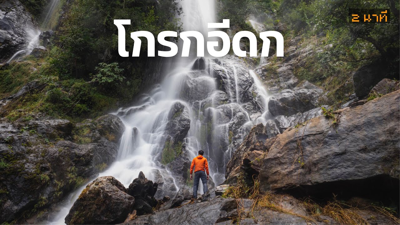
Krok E-Dok Waterfall, Saraburi is one of the most demanding and rewarding rainforest hikes in Saraburi. Rather than being a waterfall you can simply drive up to, this is a genuine forest trek into the Chet Khot–Pong Kon Sao nature zone, an area closely connected with the forested mountain landscape on the Khao Yai side. That setting gives the waterfall a very different character from ordinary roadside nature attractions. Visitors come here not only to see water, but to earn the view through a real trail experience.
The waterfall is widely known among Thai hikers as one of the tallest waterfalls in central Thailand. Tourism sources describe it as a large 7-tier waterfall with a total height of around 350 meters. Water is present through much of the year, but the site is especially striking during the rainy season when the cliff face carries much stronger flow and the surrounding forest turns intensely green. In practical travel terms, that makes Krok E-Dok both more beautiful and more physically demanding in the wet season.
What makes Krok E-Dok special is the full journey, not just the final viewpoint. The trail crosses streams, climbs steep sections, passes bamboo areas, and moves through a humid forest environment rich in ferns, mosses, mushrooms, and rain-loving plant life. Sandy patches by the stream can also act as butterfly mineral spots, adding another layer of interest for visitors who enjoy nature beyond the main waterfall itself. This is why the hike feels immersive from the start rather than becoming interesting only at the end.
The waterfall itself has the kind of scale that creates a strong arrival moment. After several hours of hiking, the vertical drop and dark wet rock walls feel dramatic and powerful. It is not the kind of waterfall built around easy access and casual swimming. Its appeal comes from height, forest enclosure, and the contrast between the difficulty of the trail and the force of the water at the destination.
Another important point is access control. Krok E-Dok is not treated as a free-form unguided forest route. Recent caretaker announcements show that hikers are registered and released in morning rounds, with recent published windows ranging from about 06:00–09:30 and 07:00–10:00 depending on the day and the arrangement. In practice, that means visitors should always check the most recent registration instructions before leaving home.
This managed entry system matters because the trail is not easy. Depending on conditions, the out-and-back route is commonly described in the range of about 6.6 to 8 kilometers, and the total trip often takes roughly 5 to 7 hours. Rain, water level, group fitness, and rest stops all affect the final timing. Even strong hikers should treat the route seriously, especially if the forest is wet.
Krok E-Dok also helps reveal a different side of Saraburi. Many travelers associate the province with temples, quick nature stops, or places close to Bangkok that are easy to visit. This waterfall shows a much deeper wilderness identity. It is one of those places that makes Saraburi feel more rugged, greener, and more adventurous than many first-time visitors expect.
Preparation is therefore part of the experience. Good grip footwear, quick-drying clothes, drinking water, snacks, and waterproof protection for valuables are all sensible essentials. A trekking pole can also be useful on stream crossings and slippery slopes. Visitors who do not hike often should assess their fitness honestly, because the route is beautiful but physically real.
One advantage of the wider area is that the Chet Khot–Pong Kon Sao zone can serve as a practical base. Travelers can stay nearby, camp, or spend a night around the study center area before starting the hike in the morning. That makes the trip safer and more comfortable, especially for people coming from Bangkok very early in the day.
Travel Information for Krok E-Dok Waterfall is straightforward by car. From Bangkok, head toward Saraburi and continue along Mittraphap Road toward Muak Lek. Before reaching the Thap Kwang area, follow the signs leading to the Chet Khot–Pong Kon Sao Nature Study and Ecotourism Center, then continue on the paved access road into the nature zone. Visitors planning to hike Krok E-Dok should confirm the current registration point and release round before departure, because the access process is managed rather than completely open-ended.
Overall, Krok E-Dok Waterfall is one of the strongest adventure destinations in Saraburi for travelers who want more than a simple sightseeing stop. It offers a high multi-tier waterfall, dense rainforest scenery, a challenging trail, and a genuine sense of immersion in nature. For hikers and adventure-minded travelers, it is one of the most memorable one-day forest routes near Bangkok.
| Name | Krok E-Dok Waterfall |
| Location | Chet Khot–Pong Kon Sao forest area, Kaeng Khoi District, Saraburi |
| Address | Main access coordination is through the Chet Khot–Pong Kon Sao Nature Study and Ecotourism Center, Moo 5, Tha Maprang Subdistrict, Kaeng Khoi, Saraburi |
| Coordinates | 14.45331, 101.21531 |
| Highlights | A high 7-tier rainforest waterfall, total height around 350 meters, stream crossings, rich fern-and-moss forest, and a serious hiking experience |
| History | A major ecotourism hiking route in the Chet Khot–Pong Kon Sao zone, promoted as one of Saraburi’s signature forest waterfall trails |
| Name Origin | Local usage links “Krok” with mountain terrain and reflects the dense, rugged character of the area |
| Distinctive Features | Natural hiking route through deep forest, steep sections, stream crossings, and a large waterfall that is most dramatic in the rainy season |
| Travel Information | Drive from Bangkok via Saraburi and Mittraphap Road, then follow the route toward the Chet Khot–Pong Kon Sao access road and confirm the current registration point before arrival |
| Current Status | Open to visitors with managed registration and release rounds |
| Open Days | Open Daily, subject to announced rounds |
| Opening Hours | Morning registration/departure is generally in the 06:00 – 10:00 range |
| Facilities | Registration point, trail caretakers/guides, parking, and basic facilities in the Chet Khot–Pong Kon Sao center zone |
| Main Areas / Zones | Forest stream route, bamboo sections, butterfly mineral spots, main waterfall viewpoint, and the 7-tier waterfall zone |
| Main Contact Number | 065-706-2959 |
| Official Website / Official Page | Amazing Thailand, Thailand Tourism Directory, Krok E-Dok trail caretaker page |
| Nearby Tourist Attractions | 1) Chet Khot–Pong Kon Sao Nature Study and Ecotourism Center 8 km 2) Chet Khot Waterfall 8 km 3) Chet Khot Viewpoint 9 km 4) Manasikarn 24 km 5) Wat Tham Phra Phothisat 30 km |
| Nearby Restaurants | 1) Khob Chon 2 km Tel. 065-562-9542, 081-795-3947 2) Baan Slate 2 km 3) Baanrai Porpiang Camping & Cafe 3 km 4) Be right back coffee 6 km 5) Krua Pa Daeng 1 9 km Tel. 086-131-0323 |
| Nearby Accommodations | 1) Chet Khot–Pong Kon Sao Nature Study and Ecotourism Center 8 km 2) Phu Pha Tawan 10 km 3) Lalanta Camping & Cafe 7 km 4) Baanrai Fa Kiang Than 8 km 5) Phu Nam Sap Resort Saraburi 9 km |
Frequently Asked Questions (FAQ)
Q: Is Krok E-Dok Waterfall open every day?
A: Yes, but visitors are admitted according to announced registration and release rounds.
Q: Do I need to register before hiking?
A: Yes. You should contact the trail caretakers in advance because access is managed in scheduled rounds.
Q: Is the trail difficult?
A: It is a fairly demanding forest hike with stream crossings, steep sections, and a long walking time, so reasonable fitness is important.
Q: How long does the trip take?
A: Most hikers should expect roughly 5 to 7 hours for the full out-and-back trip, depending on conditions and pace.
Q: How tall is the waterfall?
A: Tourism sources describe the waterfall as around 350 meters in total height and 7 tiers in structure.
Q: When is the best time to visit?
A: The rainy season and just after fresh rains are usually the most dramatic for waterfall flow and forest greenery, though the trail is also harder then.
Q: What should I bring?
A: Bring good-grip footwear, quick-drying clothes, drinking water, snacks, and waterproof protection for your valuables.
Mobile : 0892378659, 0859683520, 0818099982
Fax : 036346202
![]() Category: ●Nature and Wildlife
Category: ●Nature and Wildlife
![]() Group: ●Waterfalls
Group: ●Waterfalls
Last Update : 2 MonthAgo