lovethailand home >North Travel Attractions >Lampang Travel Attractions >Mae Phrik >Phra Bat Wang Tuang > Doi Chong National Park
TL;DR: Doi Chong National Park is located at Village No. 6, Ban Na Mai Daeng, Na Yang Subdistrict, Sop Prap District, Lampang Province, covering parts of Sop Prap, Thoen, Mae Phrik, open Daily, hours 08.00 – 16.30.

Doi Chong National Park

Open Days: Daily
Opening Hours: 08.00 – 16.30
Doi Chong National Park is located across southern Lampang and northern Lamphun, covering parts of Sop Prap, Thoen, and Mae Phrik districts in Lampang Province, as well as Li District in Lamphun Province. The park covers approximately 207,500 rai and is known for its extensive deciduous forest, mountain ridges, pine woodland, limestone cliffs, seasonal waterfalls, and a challenging trekking route to Doi Chong summit. It is one of the best places in Lampang for travelers who want to experience quiet forest, seasonal forest colors, and a more serious outdoor journey rather than a quick roadside viewpoint.
The landscape of Doi Chong National Park is made up of continuous mountain ranges and long ridge systems. Along Highway No. 106, especially near the boundary between Thoen District in Lampang and Li District in Lamphun, travelers can see dense dry dipterocarp and mixed deciduous forest on both sides of the road. Toward the end of the cool season, these forests become especially beautiful as leaves change color before falling in the dry season. The result is a warm landscape of yellow, orange, brown, and gold, giving the park a strong seasonal character.
The park is not only a scenic forest area. It also contains pine groves, high ridges, limestone cliffs, and broad viewpoints. Some areas on the ridge are relatively open and flat, with clusters of pine trees scattered across the landscape. Several cliffs serve as natural viewpoints where visitors can see sunrise, sunset, forested mountains, and the agricultural plains of Sop Prap and Ko Kha districts. This combination of deciduous forest, pine woodland, cliffs, and ridge trails makes Doi Chong different from many other natural attractions in Lampang.
Doi Chong summit is the most important destination in the park. In the past, the summit area was used as a Royal Thai Air Force telecommunication station. After a radar station was later built on Doi Inthanon, the former station on Doi Chong was discontinued, and the area came under national park management. This gives the summit both natural and historical interest. It is not simply a viewpoint but a place that reflects former strategic use of high mountain terrain.
The trek from the park headquarters to Doi Chong summit is about 7 km, but the distance alone does not describe the difficulty. The trail is steep in places, with separate ascent and descent routes. Some descending sections are very steep and covered with small gravel, requiring careful footing. The uphill walk can take more than 5 hours. Visitors who want to reach the summit must contact park staff for guidance and prepare food, water, tents, sleeping bags, flashlights, personal medicine, warm clothing, and proper trekking equipment.
A suitable plan for the Doi Chong trek is usually a multi-day trip. San Pa Kia is an important camping area along the route, where two-needle and three-needle pine trees grow more densely than in other areas. The atmosphere of this pine ridge is one of the most memorable parts of the route, with open woodland, wind through pine branches, and a cool mountain feeling. Spending the night here allows trekkers to continue toward the summit the next morning without rushing.
From the ridge and summit area, visitors can see wide plains, farmland, forested valleys, and long mountain lines stretching across Lampang. The view feels more rewarding because it must be reached by walking through the forest. Morning brings soft light and possible mist over the valleys, while evening offers warm sunset colors across the ridges. For many trekkers, the experience of reaching Doi Chong is as important as the view itself.
The vegetation along the high ridge is especially interesting. Some sections are covered with oak-like forest mixed with pine. The ground layer contains Siam tulip plants that bloom pink in the early rainy season. Another important plant is the fa mui orchid, a beautiful wild orchid associated with Doi Chong and used as a symbolic flower of the park. It blooms around October to January. Visitors should never collect orchids, wildflowers, or any plants from the park.
Pha Kan is located about 2 km from Doi Chong summit. The route descends steeply and is suitable only for careful hikers. Pha Kan is a sharp limestone cliff and is known as a good place for birdwatching and wide forest views. From the cliff, visitors can see long mountain ridges and broad forest below, while Doi Chong summit rises behind the viewpoint. Because the limestone surface can be sharp and exposed, visitors should follow staff guidance and avoid risky climbing.
Mae Ap Forest Viewpoint is located along the Thoen – Li road around kilometer markers 13 – 26. This area is suitable for visitors who want to enjoy the seasonal forest scenery without trekking to the summit. During the late cool season and dry season, the deciduous forest along the road changes color beautifully. Drivers should stop only at safe points and avoid parking on dangerous curves or narrow road sections.
Mae Nga Chang Waterfall is a small waterfall about 12 meters high, located about 2 km from the park headquarters in Na Yang Subdistrict, Sop Prap District. It has water mainly during the rainy season. Although it is not a large waterfall, it provides a peaceful natural stop close to the park headquarters. Visitors should check the season before expecting flowing water.
Tat Pu La Waterfall is a small two-level waterfall located about 1 km from the park headquarters. Like Mae Nga Chang Waterfall, it has water mainly during the rainy season. It is suitable for a short visit near the headquarters, especially for travelers who do not plan to hike to Doi Chong summit. However, small waterfalls can still have slippery rocks during the rainy season, so visitors should walk carefully.
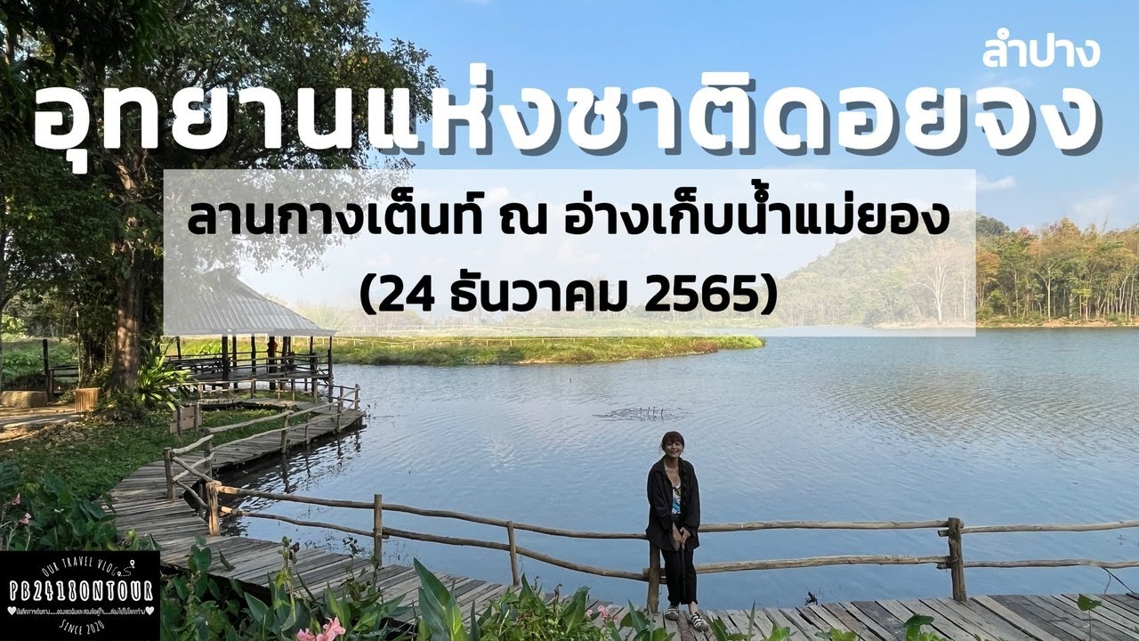
Pha Khang is a small hill opposite the park headquarters, near Huai Mae Yong Reservoir. From the hill, visitors can look down over the reservoir, the park office area, and the layered mountains in the background. This is a convenient viewpoint for visitors with limited time. The reservoir also gives the headquarters area a calm and pleasant atmosphere, suitable for resting before or after a nature walk.
The park also contains several other caves and waterfalls that have been surveyed but are not fully developed for tourism, including Huai Mae Pu Waterfall, Huai Khang Waterfall, Pha Yong, Huai Daeng Cave, Kon Hoi Cave, and Mae Keng Cave. These places show the park’s broader natural potential, but they should not be visited without staff permission and guidance. Undeveloped natural sites may have difficult access, safety risks, and conservation restrictions.
Facilities at Doi Chong National Park are basic. The park is suitable for camping and self-prepared nature travel rather than resort-style tourism. Visitors should bring tents, sleeping equipment, drinking water, food, flashlights, cooking equipment, and other personal supplies. There is no full-service restaurant inside the park. Those who need fresh food or supplies should buy them in Sop Prap town before entering the park.
Camping at Doi Chong requires responsibility. The park generates its own electricity, and water comes from Huai Mae Nga Chang. Visitors should use water and electricity carefully, avoid loud noise, do not light fires outside permitted areas, and manage all waste properly. This kind of travel offers a closer connection with nature, but it requires more preparation and discipline than staying in a hotel.
Getting There from Lampang city is most convenient by private car. Use Highway No. 1 southward for about 54 km to Sop Prap District Office, then turn right onto the Ban Lai – Ban Kaen road. At Ban Na Mai Daeng, about 8 km from Phahonyothin Road, turn left and continue about 7 km to Doi Chong National Park headquarters. The total distance from Lampang city to the park headquarters is about 68 km.
Travelers on Highway No. 106 between Thoen District and Li District can enjoy the forest scenery along the road, especially during the late cool season when the forest changes color. This road passes through attractive deciduous forest, but it is a mountain route with curves and changing road conditions. Drivers should use caution and stop only at safe viewpoints.
The best season depends on the type of trip. Late cool season and dry season are good for forest colors. Early rainy season is good for Siam tulip flowers. October to January is the fa mui orchid blooming period. Anyone planning to climb Doi Chong summit must check current park announcements and booking conditions in advance, because summit access and camping areas may close seasonally for safety or forest recovery.
Food options are mainly found in Sop Prap town and along access roads before entering the park. Nearby choices include local restaurants in Sop Prap, Sop Prap pork-rib noodle shops, Luen Cafe, Ban Tong Cafe, and Krua Ban Suan Sop Prap. Trekkers and campers should buy food, drinking water, and supplies before entering the park because options inside the park are limited.
Accommodation options include the park camping area and local stays in Sop Prap, Thoen, or nearby districts. Visitors who want a true nature experience can camp in permitted areas by contacting park staff in advance. Those who prefer rooms, toilets, restaurants, and easier onward travel may stay in Sop Prap or Thoen and visit the park during the day.
Visitors should follow all park rules. Do not leave trash, collect orchids or wildflowers, catch animals, feed wildlife, light fires outside permitted areas, or walk off trail. Do not attempt the Doi Chong summit trek without park staff guidance. Some trail sections are steep and slippery with gravel or dry leaves. Proper trekking shoes, enough water, and clear communication with park staff are essential.
Doi Chong National Park is best suited for travelers who want a deeper forest experience in Lampang. It offers seasonal deciduous forest, pine ridges, cliffs, waterfalls, camping, wild orchids, Siam tulips, and a challenging summit route. Its beauty is not only in the summit view but in the changing forest, the quiet ridges, and the feeling of entering a less commercial natural area.
Overall, Doi Chong National Park is an important protected forest area shared by Lampang and Lamphun. Its 207,500 rai include Doi Chong summit, San Pa Kia, Pha Kan, Pha Khang, Mae Nga Chang Waterfall, Tat Pu La Waterfall, Mae Ap forest scenery, and several lesser-developed natural sites. With careful preparation, respect for park rules, and responsible travel behavior, Doi Chong can be one of Lampang’s most memorable mountain and forest experiences.
| Name | Doi Chong National Park |
| Location | Village No. 6, Ban Na Mai Daeng, Na Yang Subdistrict, Sop Prap District, Lampang Province, covering parts of Sop Prap, Thoen, Mae Phrik, and Li District in Lamphun Province |
| Address | Doi Chong National Park Headquarters, Village No. 6, Ban Na Mai Daeng, Na Yang Subdistrict, Sop Prap District, Lampang 52170 |
| Highlights | Doi Chong summit, San Pa Kia pine ridge, Pha Kan, Pha Khang, Mae Ap forest viewpoint, seasonal forest colors, fa mui orchids, Siam tulips, Mae Nga Chang Waterfall, and Tat Pu La Waterfall |
| History | Doi Chong summit was formerly used as a Royal Thai Air Force telecommunication station before the area came under national park management. |
| Name Origin | The park is named after Doi Chong summit, the key mountain and main trekking destination in the area. |
| Distinctive Features | A 207,500-rai protected forest with dry dipterocarp forest, mixed deciduous forest, pine woodland, limestone cliffs, viewpoints, and a challenging trekking route |
| Travel Information | From Lampang city, take Highway No. 1 south for about 54 km to Sop Prap District, turn right toward the Ban Lai – Ban Kaen road, then continue through Ban Na Mai Daeng to the park headquarters. Total distance is about 68 km. |
| Current Status | Open as a national park and natural attraction. Doi Chong summit trekking and overnight camping on the route require advance contact with park staff and must follow current access announcements. |
| Open Days | Daily |
| Opening Hours | 08.00 – 16.30 / Summit Trekking And Overnight Camping Must Be Arranged With Park Staff In Advance |
| Fees | Please Confirm Current Entrance, Camping, And Vehicle Fees With The Park Before Visiting |
| Facilities | Visitor center, camping area, parking area, toilets, viewpoints, trekking routes, and basic nature-camping facilities. Visitors should bring food, drinking water, and personal equipment. |
| Main Areas / Zones | Park headquarters, Doi Chong summit, San Pa Kia, Pha Kan, Pha Khang, Huai Mae Yong Reservoir, Mae Nga Chang Waterfall, Tat Pu La Waterfall, and Mae Ap forest viewpoint |
| Caretaker | Department Of National Parks, Wildlife And Plant Conservation / Doi Chong National Park |
| Main Contact Number | Doi Chong National Park, Tel. 081-724-6732 / Email: doichong_np13@hotmail.com |
| Recommended Season | Late cool season and dry season are ideal for forest colors, early rainy season for Siam tulips, and October – January for fa mui orchids. |
| Visitor Guidelines | Do not trek to the summit without park staff, do not collect orchids or wildflowers, do not light fires outside permitted areas, do not litter, stay on trails, and prepare proper trekking equipment. |
| Nearby Tourist Attractions | 1. Pha Khang And Huai Mae Yong Reservoir, about 0.5 km 2. Tat Pu La Waterfall, about 1 km 3. Mae Nga Chang Waterfall, about 2 km 4. Doi Chong Summit Trailhead, about 7 km 5. Sop Prap Town Center, about 15 km 6. Mae Ap Forest Viewpoint On The Thoen – Li Road, about 30 km 7. Thoen Town Center, about 45 km |
| Nearby Restaurants | 1. Local Restaurants In Sop Prap Town, about 15 km 2. Sop Prap Pork Rib Noodle Shop, about 10 km 3. Krua Ban Suan Sop Prap, about 15 km, Tel. 090-971-3262, 054-242-282 4. Luen Cafe, about 15 km 5. Ban Tong Cafe, about 16 km 6. Roadside Restaurants On The Sop Prap – Thoen Route, about 20 km |
| Nearby Accommodations | 1. Doi Chong National Park Camping Area, about 0 km, Tel. 081-724-6732 2. Local Accommodations In Sop Prap District, about 15 km 3. Camping Kanokkorn Garden, about 25 km 4. Thoen Park Resort / Thoen Park, about 45 km, Tel. 081-892-6386, 086-447-3200 5. Thoen 5 Star Rooms / Hotel, about 45 km, Tel. 098-631-3383 6. Accommodations In Lampang City, about 68 km |
Frequently Asked Questions (FAQ)
Q: Where is Doi Chong National Park located?
A: Doi Chong National Park is located at Ban Na Mai Daeng, Na Yang Subdistrict, Sop Prap District, Lampang Province, and covers parts of Sop Prap, Thoen, Mae Phrik, and Li District in Lamphun Province.
Q: What are the main attractions in Doi Chong National Park?
A: Main attractions include Doi Chong summit, San Pa Kia pine ridge, Pha Kan, Pha Khang, seasonal forest colors, fa mui orchids, Siam tulips, Mae Nga Chang Waterfall, Tat Pu La Waterfall, and Mae Ap forest viewpoint.
Q: Is trekking to Doi Chong summit difficult?
A: Yes. The trail is about 7 km from the park headquarters and includes steep sections. The uphill walk can take more than 5 hours, and visitors must contact park staff for guidance before trekking.
Q: What are the opening hours of Doi Chong National Park?
A: The park headquarters is generally open daily from 08.00 to 16.30. Summit trekking and overnight camping require advance contact with park staff.
Q: Does Doi Chong National Park have accommodation or restaurants?
A: The park mainly provides camping areas and basic nature-camping facilities. Visitors should bring their own food, drinking water, tents, sleeping gear, and personal equipment.
Q: How can travelers get to Doi Chong National Park?
A: From Lampang city, take Highway No. 1 south to Sop Prap District, then continue via the Ban Lai – Ban Kaen road and Ban Na Mai Daeng to the park headquarters. The total distance is about 68 km.
Q: What is the best season to visit Doi Chong National Park?
A: Late cool season and dry season are suitable for forest colors, early rainy season for Siam tulips, and October to January for fa mui orchids.
Q: What nearby attractions can be visited after Doi Chong National Park?
A: Nearby places include Pha Khang, Huai Mae Yong Reservoir, Tat Pu La Waterfall, Mae Nga Chang Waterfall, Sop Prap town, Mae Ap forest viewpoint, and Thoen town.
![]() Category: ●Nature and Wildlife
Category: ●Nature and Wildlife
![]() Group: ●National Parks and Marine Reserves
Group: ●National Parks and Marine Reserves
Last Update : 2 MonthAgo
Doi Chong National Park Map
Gellery
Recommend


