lovethailand home >North Travel Attractions >Sukhothai Travel Attractions >Khiri Mat >Si Khirimat > Ramkhamhaeng National Park (Khao Luang)
TL;DR: Ramkhamhaeng National Park (Khao Luang) is located at Khiri Mat, Mueang Sukhothai, and Ban Dan Lan Hoi Districts, Sukhothai Province, open Daily, hours 08.00 – 16.30.

Ramkhamhaeng National Park (Khao Luang)
")
Open Days: Daily
Opening Hours: 08.00 – 16.30
Ramkhamhaeng National Park, also known as Khao Luang, is one of the most distinctive national parks in Sukhothai Province. It is a rare destination where mountain scenery, forest ecology, waterfalls, caves, medicinal plants, ancient routes, local legends, and historical remains from the Sukhothai period exist within the same protected landscape. For foreign travelers, this park offers a deeper way to understand Sukhothai beyond the famous historical park. It reveals the natural highlands that shaped the region, the sacred mountain associated with local beliefs, and the ecological landscape that continues to support communities around the old capital.
The park is widely known among Thai travelers as Khao Luang Sukhothai. The name Khao Luang refers to the great mountain that rises prominently above the surrounding plains. From a distance, the mountain range appears as a strong natural landmark standing behind rice fields, villages, and the historical landscape of Sukhothai. Its position makes it visually powerful and culturally meaningful. Visiting this park is therefore not only a nature trip, but also a journey into the mountain landscape that has long been part of Sukhothai’s identity.
Ramkhamhaeng National Park was officially established on 27 October 1980 and is recognized as Thailand’s first historical national park. The name was chosen in honor of King Ramkhamhaeng the Great, one of the most important kings of the Sukhothai Kingdom. The official name also helps distinguish this park from Khao Luang National Park in Nakhon Si Thammarat. By carrying the name of King Ramkhamhaeng, the park reflects the connection between nature, history, and the cultural foundations of Thailand.
The park covers approximately 213,215 rai, or about 341 square kilometers, across Mueang Sukhothai, Khiri Mat, and Ban Dan Lan Hoi Districts. Its terrain is mostly mountainous, with forested slopes, streams, waterfalls, caves, viewpoints, and natural grasslands on the high ridges. This varied geography creates important habitats for plants and animals while also serving as a watershed for nearby communities. The forests help retain moisture, protect soil, support biodiversity, and maintain the environmental balance of the Sukhothai plain.
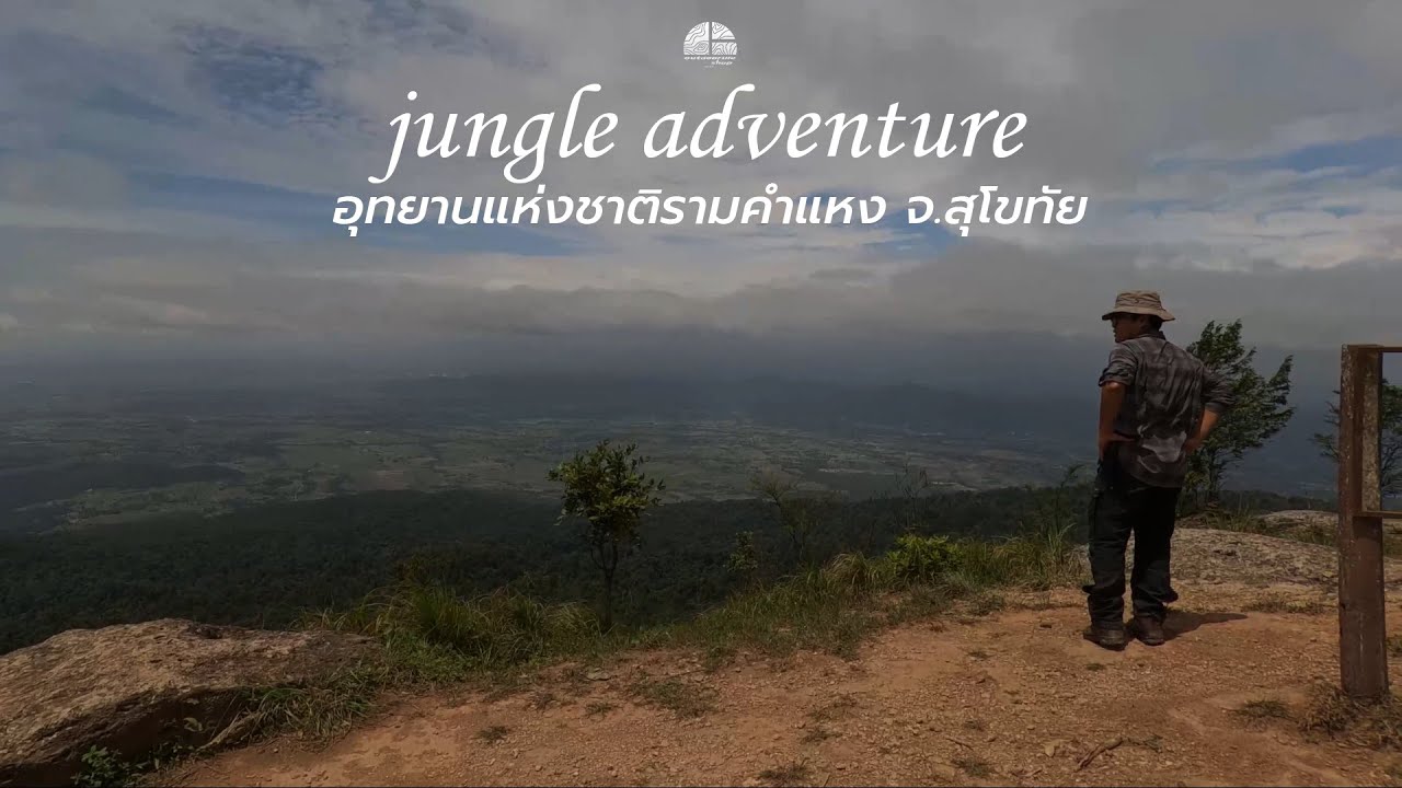
Khao Luang is the main highlight of the park and the primary goal for hikers. The summit area rises to about 1,200 meters above sea level, making it the highest point in Sukhothai Province. The air is noticeably cooler than the lowlands, especially during the cool season and after the rains. Mist often covers the forested ridges, and the summit area offers wide views over Sukhothai’s plains, fields, villages, and mountain lines. Many visitors hike up to camp overnight so they can watch the sunset, stargaze, and wake up early for sunrise and sea of mist.
The summit area consists of four important peaks: Khao Narai, Khao Phra Mae Ya, Khao Phu Ka, and Khao Phra Chedi. Each peak has its own character. Khao Narai is known for broad scenic views. Khao Phra Mae Ya is associated with the revered figure of Phra Mae Ya, who is deeply respected in Sukhothai. Khao Phu Ka offers beautiful forest and mountain scenery, while Khao Phra Chedi is connected with religious symbolism and historical memory. Together, these peaks make Khao Luang more than a hiking destination. They form a cultural mountain landscape where natural beauty and local beliefs are closely linked.
The hiking route to Khao Luang is about 3.7 kilometers long, but the trail is steep in many sections and requires good preparation. The route passes through forest, tree roots, rocks, rest points, and changing vegetation as the elevation increases. Visitors should start early in the day and should not begin the climb too late. Essential items include drinking water, dry food, a flashlight, warm clothing, personal medicine, a trash bag, and proper hiking shoes. Porters may be available during the open hiking season, but travelers should confirm availability with the park before arrival.
At the top of Khao Luang, visitors will find open natural grassland mixed with shrubs and forest patches. The atmosphere is very different from the lowland area. Morning air is cool, and mist may move across the ridgeline. In the evening, the summit becomes one of the most atmospheric places in Sukhothai for sunset. From the high viewpoints, travelers can see forests, rice fields, communities, and distant hills stretching across the horizon. The beauty of Khao Luang lies not only in its height, but also in the way it reveals the relationship between the mountain and the historical plain below.
Several interesting points can be found along the hiking route. Sai Ngam is a large banyan tree that serves as a natural rest point for hikers. Its spreading branches create a shaded space that feels like a natural gateway into the higher forest. Another notable point is Plong Nang Nak, a small natural pit linked to local legends of Phra Ruang. These stories add cultural depth to the hike. The trail is therefore not only a physical challenge, but also a route filled with local beliefs, oral history, and the living imagination of Sukhothai people.
Ramkhamhaeng National Park is also important for its plant diversity and medicinal herbs. Species associated with the area include local forest plants and traditional medicinal plants such as wan dong mai ru lom, hom klai dong, nang khum, hanuman prasan kai, and kamlang suea khrong. These plants reflect the richness of the Khao Luang forest and the long relationship between local communities and natural knowledge. The lower area near the park office includes a herbal plant area known as Suan Lum or Suan Lumpiniwan, where visitors can learn more about local plant resources before exploring deeper into the park.
Wildlife in the park includes barking deer, wild boar, monkeys, squirrels, tree shrews, birds, reptiles, and many smaller forest animals. Seeing large wildlife is not guaranteed, as most animals avoid people and remain hidden in quiet areas. However, the sounds of birds, insects, and forest movement remind visitors that the park is an active habitat. Travelers should move quietly, avoid feeding animals, keep food secure, and respect the natural behavior of wildlife. A national park is not only a recreation area; it is primarily a protected home for living species.
The historical dimension of Ramkhamhaeng National Park is one of its most unusual qualities. The park contains historical gates such as Pratu Pa, Pratu Makha, Pratu Plueai, and Pratu Phra Ruang. These gates are located around the lower mountain area and are associated with old routes, defensive landscapes, and local legends. Pratu Phra Ruang is especially connected with stories of Phra Ruang, a legendary figure deeply tied to Sukhothai memory. These features show that Khao Luang was not an isolated mountain, but part of a wider historical and cultural landscape.
The Buddha footprint carved on slate is another important historical feature. It is believed to be about 600 years old and is associated with the period of King Maha Thammaracha Lithai. The footprint reflects Buddhist devotion in the Sukhothai era. Khao Pu Cha Prang is another archaeological site in the park, showing Khmer artistic influence from the Baphuon style. It was likely connected with religious activities or a stopping point for travelers in the past. These remains make the park especially valuable because visitors can experience forest ecology and historical heritage in the same journey.
The caves in the park also connect nature with belief. Tham Phra Narai once contained an image of Avalokitesvara, although only the base remains today. Tham Phra Mae Ya was once associated with the image of Phra Mae Ya, now enshrined at the Phra Mae Ya Shrine in front of Sukhothai City Hall. The belief in Phra Mae Ya is central to Sukhothai’s local identity, and its connection with Khao Luang gives the mountain a spiritual dimension. For foreign visitors, these stories help explain why the mountain is meaningful not only as a viewpoint, but also as a sacred cultural landscape.
Phra Ruang Road is another important historical feature connected with this landscape. This ancient route is believed to have linked Kamphaeng Phet, Sukhothai, and Si Satchanalai over a distance of more than 123 kilometers. It functioned as an important communication and strategic route in the past. Its association with the Khao Luang area helps visitors understand that mountains, cities, routes, and religious sites were part of an interconnected historical system. A trip to Ramkhamhaeng National Park can therefore deepen one’s understanding of Sukhothai as a living cultural geography rather than only a group of ancient monuments.
Sai Rung Waterfall is one of the best-known natural attractions in the park. The waterfall originates from the Khao Chedi area and drops down from a high cliff through forested terrain. When sunlight hits the spray at the right time, the water droplets create a rainbow-like effect, giving the waterfall its name, which means “rainbow waterfall.” It is especially attractive during the rainy season and the early cool season when the forest is lush and the water flow is stronger. Visitors should take care on wet rocks and follow park instructions for safety.
The park also has a nature study trail of about 3 kilometers, taking approximately 2 hours to walk. This route is suitable for visitors who want a shorter educational experience rather than a full summit hike. The trail passes herbal plant areas, dry evergreen forest, Sai Ngam, soil and rock formations, and Hin Rang Waterfall. Interpretive signs along the route help explain the natural environment. This makes the trail suitable for families, students, and travelers who want to learn about forest ecology without taking on the more demanding climb to Khao Luang.
The best time to visit Ramkhamhaeng National Park is generally from September to February. During this period, the weather is cooler, the forest is fresh, and the summit area has a higher chance of misty views. Late rainy season and early cool season are especially beautiful for photography and hiking. The hot season is still suitable for short visits around the park office and nature trail, but visitors should bring enough water and sun protection. During the rainy season, waterfalls and forests are at their most vibrant, but trails may become slippery, so caution is essential.
Getting There is easiest by private car. From Bangkok, travelers can take Highway 32 through Nakhon Sawan, continue on Highway 1 toward Kamphaeng Phet, and then use Highway 101 toward Khiri Mat District in Sukhothai. From there, turn toward the park office for about 16 kilometers. From Sukhothai town, drive toward Khiri Mat District and continue to the park entrance. Travelers using public transport can get off at Khiri Mat and hire a local songthaew or local vehicle to the park. It is best to agree on the fare and return time clearly before entering the park.
The visitor service area provides basic facilities such as a visitor center, welfare shop, camping ground, toilets, parking area, and staff contact point. The summit area of Khao Luang is more limited and natural, so hikers who plan to camp should bring food, water, sleeping gear, a flashlight, warm clothing, and a personal trash bag. Accommodation, tents, camping spaces, and equipment should be checked or reserved through the Department of National Parks system or the park’s official channels, especially during weekends, long holidays, and the main hiking season.
The national park entrance fee is 40 baht for Thai adults and 20 baht for Thai children. For foreign visitors, the fee is 200 baht for adults and 100 baht for children. A vehicle fee applies, such as 30 baht for a car. Additional fees may apply for camping, tents, equipment, or other services depending on the type of stay and current park regulations. Travelers should confirm details before arrival, especially if planning to hike to the summit or stay overnight.
The park can be understood in several main zones. The first is the park office and visitor service zone, where travelers receive information and contact staff. The second is the nature study trail zone for short educational walks. The third is Sai Rung Waterfall zone for waterfall and forest scenery. The fourth is the Khao Luang hiking trail zone. The fifth is the summit and camping zone. The sixth is the historical and cultural zone, which includes ancient gates, the Buddha footprint, Khao Pu Cha Prang, Tham Phra Narai, Tham Phra Mae Ya, and traces of Phra Ruang Road. Travelers should choose routes according to time, fitness, weather, and park announcements.
The park is managed by the Department of National Parks, Wildlife and Plant Conservation. Park officers are responsible for conservation, visitor management, safety, fire prevention, environmental education, and protection of natural and historical resources. The latest publicly available information identifies Mr. Wichai Thaojaiwong as the head of Ramkhamhaeng National Park. Managing this park requires balancing conservation and tourism because the area contains forests, wildlife, archaeological remains, hiking routes, and local community interests.
Ramkhamhaeng National Park is suitable for many types of travelers. Hikers can climb Khao Luang and camp on the summit. Families can visit the visitor center, nature trail, and accessible waterfall areas. History lovers can explore ancient gates, the Buddha footprint, Khao Pu Cha Prang, caves, and the story of Phra Ruang Road. Photographers can capture mist, sunrise, sunset, forest scenery, and sweeping views over Sukhothai. Foreign travelers who want to understand Sukhothai beyond the ancient city will find that Khao Luang adds an essential natural and cultural layer to the province.
Visitors should follow responsible travel practices. Do not litter, do not remove plants, rocks, flowers, or natural materials, do not write on archaeological remains or signs, do not feed wildlife, and do not walk outside marked routes. Hikers should assess their health honestly and prepare personal medication if needed. Solo travelers should inform park staff before taking the trail. It is also important to check seasonal closure announcements, especially for the Khao Luang summit and camping area, as these areas may close annually for ecological recovery and safety management.
Ramkhamhaeng National Park can be planned in several ways. A 1-day trip is suitable for the visitor area, nature trail, and waterfall depending on the season. A 2-day, 1-night trip is better for travelers who want to hike to Khao Luang, camp on the summit, and watch sunrise. With more time, visitors can combine the park with Sukhothai Historical Park, Ramkhamhaeng National Museum, Wat Si Chum, Wat Mahathat, and Si Satchanalai Historical Park. This creates a well-rounded Sukhothai itinerary that includes nature, history, culture, and outdoor learning.
Ramkhamhaeng National Park is therefore much more than a scenic mountain destination. It is a protected natural landscape, a watershed forest, a historical mountain, a place of local belief, and a gateway to understanding Sukhothai from a wider perspective. Travelers who visit Khao Luang experience the living connection between forest, mountain, ancient routes, sacred stories, and the old capital below. For anyone seeking a meaningful nature and culture journey in Thailand, this park is one of Sukhothai’s most valuable destinations.
| Name | Ramkhamhaeng National Park (Khao Luang) |
| Location | Khiri Mat, Mueang Sukhothai, and Ban Dan Lan Hoi Districts, Sukhothai Province |
| Address | 124 Moo 2, Si Khiri Mat Subdistrict, Khiri Mat District, Sukhothai 64160, Thailand |
| Coordinates | 16.8779, 99.6909 |
| Highlights | Khao Luang summit, panoramic viewpoints, sea of mist, Sai Rung Waterfall, nature trails, medicinal plants, and historical remains from the Sukhothai period |
| History | Established as a national park on 27 October 1980 and recognized as Thailand’s first historical national park |
| Name Origin | Named in honor of King Ramkhamhaeng the Great, reflecting the park’s strong connection with Sukhothai history |
| Distinctive Features | A national park combining mountains, forests, waterfalls, caves, medicinal plants, wildlife, and archaeological remains in one protected landscape |
| Travel Information | From Bangkok, take Highway 32 via Nakhon Sawan, continue on Highway 1 toward Kamphaeng Phet, then use Highway 101 toward Khiri Mat District and continue about 16 km to the park office. Public transport users can get off at Khiri Mat and hire local transport to the park. |
| Current Status | Open daily, while the Khao Luang summit and camping area may close seasonally according to park announcements |
| Open Days | Daily |
| Opening Hours | 08.00 – 16.30; hiking start times follow park regulations |
| Fees | Thai visitors: adults 40 baht, children 20 baht Foreign visitors: adults 200 baht, children 100 baht Car fee: 30 baht |
| Facilities | Visitor center, welfare shop, camping ground, toilets, parking area, staff contact point, tent service, camping equipment, and porter service during available periods |
| Main Areas / Zones | 1. Park Office And Visitor Center Zone 2. Nature Study Trail Zone 3. Sai Rung Waterfall Zone 4. Khao Luang Hiking Trail Zone 5. Khao Luang Summit And Camping Zone 6. Historical Zone With Ancient Gates, Buddha Footprint, Khao Pu Cha Prang, Tham Phra Narai, And Tham Phra Mae Ya |
| Caretaker | Department of National Parks, Wildlife and Plant Conservation / Head of Ramkhamhaeng National Park: Mr. Wichai Thaojaiwong |
| Main Contact Number | 098-883-9297, DNP Hotline 1362 |
| Official Website / Official Page | Ramkhamhaeng National Park Official Page / National Park Accommodation Reservation System, Department of National Parks, Wildlife and Plant Conservation |
| Nearby Tourist Attractions | 1. Sai Rung Waterfall, about 5 km 2. Sukhothai Historical Park, about 25 km 3. Ramkhamhaeng National Museum, about 26 km 4. Wat Si Chum, about 27 km 5. Wat Mahathat Sukhothai, about 26 km |
| Nearby Restaurants | 1. Na Khothai, about 16 km, Tel. 062-949-1715 2. Jae Hae Sukhothai Noodles, about 19 km 3. Kuay Tiew Thai Ta Pui, about 19 km, Tel. 084-686-8928 4. Fueng Fah Pla Mae Nam, about 20 km, Tel. 061-284-3800, 092-341-7926 5. Café Amazon Muang Kao Branch, about 16 km |
| Nearby Accommodations | 1. Thai Thai Sukhothai Resort, about 15 km, Tel. 084-932-1006 2. Sukhothai Garden, about 17 km, Tel. 091-843-1537 3. Le Charme Sukhothai Resort, about 17 km, Tel. 055-633-333, 02-642-5497 4. Scent of Sukhothai Resort, about 16 km 5. Legendha Sukhothai Resort, about 17 km |
Frequently Asked Questions (FAQ)
Q: Where is Ramkhamhaeng National Park located?
A: Ramkhamhaeng National Park is located in Sukhothai Province, covering parts of Khiri Mat, Mueang Sukhothai, and Ban Dan Lan Hoi Districts. The park office is in Si Khiri Mat Subdistrict, Khiri Mat District.
Q: What is the main highlight of Ramkhamhaeng National Park?
A: The main highlight is Khao Luang Sukhothai, a mountain summit about 1,200 meters above sea level, with hiking trails, viewpoints, sea of mist, waterfalls, medicinal plants, and historical remains.
Q: Is Khao Luang suitable for beginner hikers?
A: It is suitable for reasonably fit beginners who prepare properly. The trail is not very long, but it has several steep sections, so hikers should start early and bring water, food, hiking shoes, and camping gear if staying overnight.
Q: How much is the entrance fee?
A: The entrance fee is 40 baht for Thai adults and 20 baht for Thai children. For foreign visitors, it is 200 baht for adults and 100 baht for children. A car fee of 30 baht applies.
Q: When is the best time to visit Ramkhamhaeng National Park?
A: September to February is generally the best period, with cooler weather, greener forest, and a good chance of seeing mist on Khao Luang. Travelers should check park announcements before visiting.
Q: Can visitors camp on Khao Luang summit?
A: Camping is available during the open season. Visitors should contact the park in advance because the summit and camping area may close annually for ecological recovery and safety management.
Q: Can travelers reach the park by public transport?
A: Yes. Travelers can take public transport to Khiri Mat District and then hire a local songthaew or local vehicle to the park. It is best to agree on the fare and return time before entering the park.
Q: How many days should travelers plan for this park?
A: A 1-day visit is enough for the visitor area, nature trail, and waterfall. Travelers who want to hike to Khao Luang and watch sunrise should plan a 2-day, 1-night trip.
Tel : 025620760
![]() Category: ●Nature and Wildlife
Category: ●Nature and Wildlife
![]() Group: ●National Parks and Marine Reserves
Group: ●National Parks and Marine Reserves
Last Update : 3 WeekAgo
Ramkhamhaeng National Park (Khao Luang) Map
Gellery
Recommend


