
lovethailand home >North Travel Attractions >Chiang Rai Travel Attractions >Wiang Pa Pao >Wiang > Mae Tho Waterfall Forest Park
TL;DR: Mae Tho Waterfall Forest Park is located at Wiang Subdistrict, Wiang Pa Pao District, Chiang Rai, open Daily, hours 06:00 - 18:00. Highlights include A quiet multi-tiered waterfall, forest scenery, mountain streams, and a peaceful natural atmosphere.

Mae Tho Waterfall Forest Park
Open Days: Daily
Opening Hours: 06:00 - 18:00
Mae Tho Waterfall Forest Park is one of those quiet natural spots in Chiang Rai that feels far removed from crowded mainstream attractions. Located in Wiang Subdistrict, Wiang Pa Pao District, this forest park is best suited to travelers who want forest scenery, mountain streams, a modest multi-tiered waterfall, and a peaceful atmosphere rather than commercial facilities. Its appeal lies in simplicity: flowing water, dense greenery, fresh air, and a setting that still feels closely connected to the original forest landscape.
The forest park covers about 4,000 rai within the reserved forest areas of Pa Mae Poon Noi, Pa Mae Poon Luang, and Pa Huai Pong Men. It was officially established by the Royal Forest Department on 9 November 1997. The area borders natural forest on the north and east, Huai Sai stream on the south, and Ban Poon Luang village on the west. This setting gives the site an identity that is closely tied both to protected woodland and to the surrounding local community.
Geographically, Mae Tho Waterfall Forest Park forms part of a mountainous landscape at roughly 600-965 meters above sea level, with an average slope of about 40 percent. Several waterways run through and around the area. Huai Mae Tho flows through the center, Huai Hin Tho runs along the north, Huai Lu passes to the south, and Mae Poon Luang flows on the eastern side. These streams are the reason the waterfall remains a year-round attraction and why the forest stays lush and refreshing for much of the year.
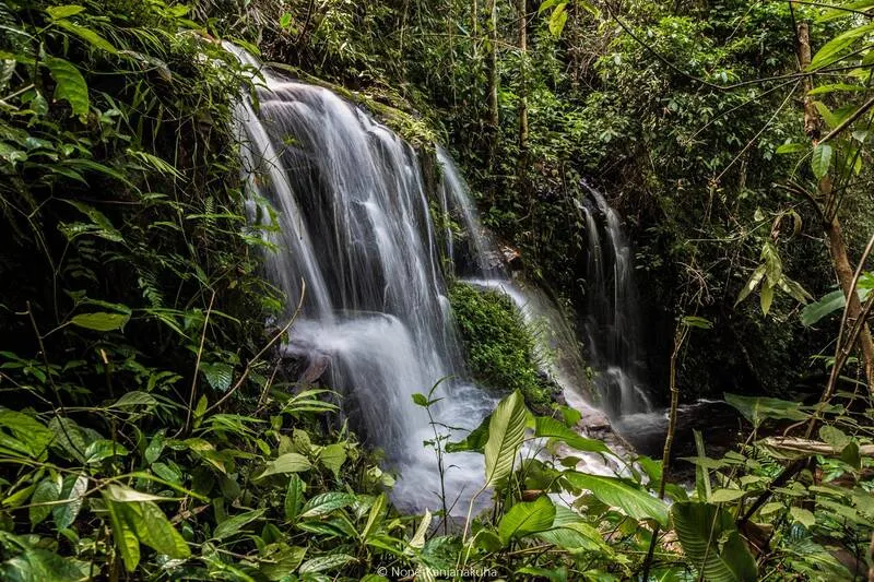
The main attraction is Mae Tho Waterfall, a small multi-tiered waterfall formed by Huai Mae Tho. Each section is generally around 5-10 meters high. It is not promoted as a dramatic mega-waterfall, but that is exactly what makes it appealing to many travelers. The site offers a more intimate forest-waterfall experience, where the sound of water and the shade of the trees matter more than built viewpoints or large tourism infrastructure. It is especially attractive for visitors who enjoy natural photography, quiet walks, and slower travel.
The surrounding forest is classified as dry evergreen forest, and the plant diversity adds depth to the experience of visiting the park. Tree species recorded in the area include yang, daeng nam, ta baek, ta khian hin, makha mong, giant neem, wild mango, mafai, san, and wild longan. Lower vegetation includes bamboo species, wild banana, ginger, galangal, and ferns. Together, these create a layered forest environment that feels shaded, humid, and biologically rich.
Wildlife is another important part of the site’s character. Species reported from the area include barking deer, wild boar, civets, jungle cats, lesser mouse-deer, junglefowl, pheasants, many bird species, amphibians, and reptiles. Visitors may not always encounter wildlife directly, but the presence of these species shows that the area still functions as real habitat rather than just a scenic stop. That is why respectful travel matters here: keeping noise low, avoiding litter, and not disturbing the surroundings are all essential.
What many travelers appreciate most about Mae Tho Waterfall Forest Park is the atmosphere. This is the kind of place where the forest itself becomes part of the attraction. The soundscape is dominated by water, wind, and birds rather than traffic or crowds. For travelers coming from the Chiang Mai-Chiang Rai highway corridor, the park offers a very different mood from roadside viewpoints, cafés, or town-based attractions. It feels more secluded and much closer to the natural rhythm of the upland forest.
In practical travel terms, this destination is best for people who are comfortable going beyond the main road network. The final approach involves smaller roads and rougher access than a standard city attraction. That makes private transport the most convenient option. Visitors should prepare drinking water, comfortable walking shoes with good grip, suitable clothing, and enough time for the journey in and out. During or after periods of rain, road conditions may be slower and more challenging, so extra caution is wise.
Facilities are basic. Available information indicates that there are restrooms, but there are no park houses for overnight stays. Travelers who want to camp need to bring their own tent and contact the site staff directly for permission. Because of this, many visitors choose to stay in Wiang Pa Pao or near Highway 118 and visit the waterfall as a day trip instead. That arrangement works well for travelers who want easier access to restaurants, fuel stations, and lodging while still enjoying a forest destination during the day.
The name Mae Tho is closely linked to Huai Mae Tho, the stream that runs through the area and gives rise to the waterfall. In northern Thailand, place names often reflect local waterways, landforms, or village geography, and Mae Tho follows that pattern. The name therefore reinforces the site’s identity as a stream-fed forest landscape rather than a built recreation park.
Travel Information from Chiang Rai city generally follows Highway 1 to the Mae Suai intersection for about 22 kilometers, then Highway 1019 to Wiang Pa Pao for about 66 kilometers. From there, the route continues along an unpaved road for around 10 kilometers to Ban Mae Poon Lang, followed by another approximately 10 kilometers on a secondary access route toward the waterfall area. Travelers coming from Chiang Mai can also use Highway 118 toward Wiang Pa Pao and then continue inward. Because the final section is not a standard urban road, driving carefully and allowing extra time is strongly recommended.
For GPS navigation, an accessible reference point used for directions is 19.424078, 99.386837. This helps travelers plan their route more accurately, especially once they leave the main highway network. Even with navigation support, however, it remains sensible to travel during daylight and to avoid rushing the final section of the route.
Mae Tho Waterfall Forest Park may not be as widely publicized as some of Chiang Rai’s best-known attractions, but that is part of its strength. It suits travelers who enjoy quieter natural destinations, forest landscapes, and less commercialized experiences. For anyone building a Chiang Rai itinerary around waterfalls, upland scenery, and peaceful nature-based travel, this forest park deserves consideration as a rewarding detour in Wiang Pa Pao District.
| Name | Mae Tho Waterfall Forest Park |
| Location | Wiang Subdistrict, Wiang Pa Pao District, Chiang Rai |
| Address | Within Pa Mae Poon Noi, Pa Mae Poon Luang, and Pa Huai Pong Men Reserved Forest Areas, Wiang Subdistrict, Wiang Pa Pao District, Chiang Rai |
| Coordinates | 19.424078, 99.386837 |
| Highlights | A quiet multi-tiered waterfall, forest scenery, mountain streams, and a peaceful natural atmosphere |
| History | Officially established by the Royal Forest Department on 9 November 1997 |
| Name Origin | Named after Huai Mae Tho, the stream flowing through the center of the area and forming the waterfall |
| Distinctive Features | Mountain forest terrain at 600-965 meters above sea level with dry evergreen forest and year-round water flow |
| Travel Information | From Chiang Rai, take Highway 1 to the Mae Suai intersection for about 22 km, continue on Highway 1019 to Wiang Pa Pao for about 66 km, then follow an unpaved road for about 10 km to Ban Mae Poon Lang and another secondary route for around 10 km to the waterfall area |
| Current Status | No permanent closure announcement was found, and the site still appears in related tourism and government-linked systems |
| Open Days | Daily |
| Opening Hours | 06:00 - 18:00 |
| Facilities | Restrooms, self-brought tent camping with prior permission, no park houses |
| Main Areas / Zones | Huai Mae Tho stream, waterfall tiers, dry evergreen forest zone, surrounding stream corridors |
| Caretaker | Protected Areas Regional Office 15 (Chiang Rai) |
| Main Contact Number | 053711402 |
| Official Website / Official Page | Protected Areas Regional Office 15 (Chiang Rai), E-mail: mfcd_15@hotmail.com |
| Nearby Tourist Attractions | 1) Khun Chae National Park Approx. 27 km 2) Mae Kachan Hot Spring Approx. 35 km 3) Thaweesin Hot Spring Approx. 37 km 4) Wat Phra That Mae Chedi Approx. 34 km 5) Doi Mod Approx. 30 km |
| Nearby Restaurants | 1) Ban Mo Noodle Approx. 17 km Tel. 097-930-5775 2) Janchay Restaurant Wiang Pa Pao Approx. 18 km Tel. 080-122-3395, 093-221-4259 3) Mengrai by Treetop Approx. 19 km Tel. 065-4295623 4) WongLor Restaurant & Bar Approx. 18 km Tel. 053-648528 5) Inthanin Coffee Wiang Pa Pao Approx. 18 km Tel. 089-851-3788 |
| Nearby Accommodations | 1) Palm Hug Resort Approx. 17 km Tel. 090-332-2866 2) Na Bua Villa Chiangrai Approx. 20 km Tel. 097-974-7201 3) Full House Resort Approx. 19 km Tel. 080-502-4506 4) Phoomtada Homestay Approx. 32 km 5) Baan Ta Auan Resort Approx. 20 km Tel. 093-229-0044 |
Frequently Asked Questions (FAQ)
Q: Where is Mae Tho Waterfall Forest Park?
A: It is in Wiang Subdistrict, Wiang Pa Pao District, Chiang Rai, within protected reserved forest areas.
Q: What is the main highlight of this place?
A: Its main appeal is a quiet multi-tiered waterfall surrounded by forest, streams, and a calm natural atmosphere.
Q: When is the best time to visit?
A: It can be visited year-round, but the rainy season through the cool season usually offers the greenest scenery and the fullest water flow.
Q: Are there park houses for overnight stays?
A: No. Visitors who want to stay overnight need to bring their own tent and contact the staff directly for permission.
Q: Is private transport recommended?
A: Yes. Private transport is the most practical choice because the final approach uses smaller and rougher roads beyond the main highway.
Q: Is there a GPS reference point for navigation?
A: Yes. A usable navigation reference is 19.424078, 99.386837.
Tel : 053711402
 Tel : 053711402
 Category: ●Nature and Wildlife
 Group: ●National Parks and Marine Reserves
Last Update : 5 MonthAgo
 Last Update : 5 MonthAgo
 Click to Access the Navigation Map GPS
Mae Tho Waterfall Forest Park Map
Recommend

 Art, Culture and Heritage
 Historical Sites and Monuments(3)
 Landmarks and Memorials(7)
 Art, Craft Centres, Tradition(6)
 Museums(8)
 Historic Homes and Cities(1)
 Educational Places
 Museum for Study(1)
 Library(1)
 Educational Gardens, Farm(3)
 Places of Worship
 Temple(38)
 Other Sacred Sites(5)
 Research and Development
 Royal Project(9)
 Suburban Living
 Village, Community(16)
 Local Market(5)
National Parks and Marine Reserves(18)
Local Market(5)
National Parks and Marine Reserves(18)
 Mountain (Doi)(20)
 Dam, Reservoir, Lake(8)
 Waterfalls(16)
 Hot Springs(6)
 Caves(8)
 River, Canal(10)
 Sea, Beach(1)
 Other natural attractions(3)
 Entertainment and Agricultural
 Animal camps and shows(1)
 Farms, Parks and Ecotourism(9)
 Shopping
 Shopping and Night Market(2)
 Call Customer Service in Tourism
 Call Customer Service in Tourism(1)
 Travel Articles, Recipes
 Travel Review, Food Review(1)
 Food Menu, North Recipes(1)


