
lovethailand home >North Travel Attractions >Kamphaeng Phet Travel Attractions >Muang Kamphaeng Phet >Nakhon Chum > Wat Chedi Klang Thung
TL;DR: Wat Chedi Klang Thung is located at Nakhon Chum Subdistrict, Mueang Kamphaeng Phet District, Kamphaeng Phet Province, open Daily, hours 00.00 – 23.59.
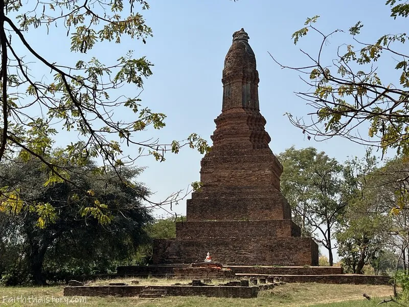
Wat Chedi Klang Thung
Open Days: Daily
Opening Hours: 00.00 – 23.59
Wat Chedi Klang Thung in Kamphaeng Phet Province is an important ancient Buddhist monument in Nakhon Chum Subdistrict, Mueang Kamphaeng Phet District. Located south of the old Nakhon Chum area, the site reflects the artistic and architectural influence of the Sukhothai period through its distinctive lotus-bud-shaped main stupa, east-facing temple plan, brick vihara base, and surrounding water boundary known as an udaka sima. Although the temple is now an archaeological ruin rather than an active monastery, its remaining structures still reveal important information about Buddhist faith, temple planning, community landscape, and the spread of Sukhothai art into Kamphaeng Phet.
This site is especially suitable for travelers who want to explore a quieter and less crowded side of Kamphaeng Phet. Unlike the major monuments inside Kamphaeng Phet Historical Park, Wat Chedi Klang Thung stands in a more open rural setting. Its stupa rises from the surrounding field, creating a calm and memorable scene. The site allows visitors to understand how Buddhist monuments were not limited to royal or urban centers, but were also embedded in local communities, agricultural areas, waterways, and village landscapes.
The name Wat Chedi Klang Thung means “the temple with a stupa in the middle of the field.” The original historical name of the temple is not clearly known, but local people named it according to its most visible feature: a large lotus-bud-shaped stupa standing prominently in an open field. This name is simple but meaningful because it directly connects the monument with its landscape. Visitors immediately understand the name when they see the stupa rising quietly from the field.
The location of the temple is historically significant because Nakhon Chum was an old settlement on the western side of the Ping River. It was closely connected with Kamphaeng Phet and the Sukhothai cultural sphere. Nakhon Chum still contains several important cultural sites, including Wat Phra Borommathat Nakhon Chum, Khlong Suan Mak, old community areas, markets, and wooden heritage houses. Wat Chedi Klang Thung is therefore part of a wider cultural landscape rather than an isolated ruin.
The temple faces east, a direction traditionally associated with auspiciousness, light, and spiritual awakening in Buddhist planning. Many ancient Buddhist monuments were oriented eastward because the direction symbolized the rising sun and the beginning of enlightenment. At Wat Chedi Klang Thung, the east-facing layout guides visitors from the front vihara toward the main stupa behind it, following a clear sacred axis.
One of the most important features of the site is the surrounding water boundary, or udaka sima. This moat-like water boundary defined the sacred area of the temple. In Buddhist tradition, boundaries are important because they separate religious space from ordinary space and help define areas used for monastic functions. The use of water as a boundary reflects a form of temple planning associated with the Sukhothai period and shows how religious meaning was expressed through landscape design.
The udaka sima also reveals practical knowledge of site planning. A water boundary helped mark the temple area, manage water, and create a calm visual setting. Even though Wat Chedi Klang Thung was located outside the city and not within a large royal temple compound, the presence of this water boundary shows that the temple was carefully planned and held religious significance for the local community.
At the front of the temple are the remains of a brick vihara base. Only the lower part of the building survives today, but its position and layout are still readable. The vihara once served as a religious assembly hall where monks and laypeople could gather for worship, chanting, and Buddhist ceremonies. Its placement in front of the main stupa follows a common pattern in ancient Thai temple planning, where the vihara leads worshippers toward the sacred stupa behind it.
The brick base of the vihara helps visitors understand construction techniques of the Sukhothai and Kamphaeng Phet cultural sphere. Raising the building above the ground gave the structure dignity, helped reduce moisture, and marked the space as religiously significant. Even though the upper structure has disappeared, the remaining base still communicates the original organization of the temple.
The main stupa behind the vihara is the heart of Wat Chedi Klang Thung. It is a lotus-bud-shaped stupa, also known in Thai as a phum khao bin or dok bua tum form. This type of stupa is strongly associated with Sukhothai art. Its base consists of several square tiers, followed by decorative molding, a reduced-angle body, and the lotus-bud top. Although parts of the upper section are damaged, the overall form remains clear and impressive.
The lotus-bud stupa carries deep Buddhist meaning. In Buddhist symbolism, the lotus represents purity, spiritual growth, and enlightenment. A lotus rises from muddy water but blooms clean and beautiful above the surface. By transforming the lotus into a stupa form, ancient craftsmen expressed Buddhist ideals through architecture. The stupa at Wat Chedi Klang Thung is therefore not merely an old structure; it is a symbolic expression of faith.
The stupa also demonstrates the connection between Kamphaeng Phet and Sukhothai. The lotus-bud form was one of the most important architectural forms of the Sukhothai period and spread to related cities and communities. Kamphaeng Phet was not only a strategic frontier city but also an important center of Buddhist culture and art. Wat Chedi Klang Thung helps visitors see how Sukhothai artistic ideas were adapted within the local context of Nakhon Chum.
From an archaeological perspective, the temple is valuable because it represents a rural or extra-urban Buddhist site with a clear plan. It was located outside Nakhon Chum, surrounded by a water boundary, and arranged with a front vihara and rear stupa. This layout helps scholars and visitors understand how religious spaces were distributed beyond city centers. Temples of this type reveal how Buddhism was integrated into settlement patterns, agricultural landscapes, and community life.
Compared with large monuments inside the old city, Wat Chedi Klang Thung is modest but highly informative. It has fewer structures, but its essential components are clear: a vihara, a main stupa, an east-facing plan, and a water boundary. This simplicity makes it easier for visitors to understand the basic structure of an ancient Buddhist temple. The site is therefore useful not only for sightseeing but also for learning.
The open-field atmosphere is one of the site’s most memorable qualities. The stupa stands quietly within a rural setting, making it feel closely connected to local land and community. This setting shows how ancient temples were part of everyday life. Religion, agriculture, waterways, and settlement were not separate worlds. They existed together within the same landscape.
For photographers, Wat Chedi Klang Thung offers a distinctive visual character. The best images often include the lotus-bud stupa together with the open field or water boundary. Morning light creates a calm atmosphere, while late afternoon light highlights the warm tones of brick and the sculptural form of the stupa. Medium-distance views often work well because they show both the monument and its surrounding landscape.
A typical visit takes around 30 minutes. Visitors who want to read the site carefully, observe the water boundary, examine the vihara base, and take photographs may spend 45 minutes to 1 hour. Because the site is outdoors, visitors should bring sun protection, drinking water, and comfortable shoes. The morning and late afternoon are the most pleasant times to visit.
Visitors should follow conservation etiquette. Do not climb on the stupa or the vihara base, do not scratch or write on ancient materials, do not move bricks or fragments, and do not leave litter. The remaining structures are valuable archaeological evidence, and responsible behavior helps protect the site for future generations.
Wat Chedi Klang Thung can be visited together with other cultural attractions in Nakhon Chum, such as Wat Phra Borommathat Nakhon Chum, Nakhon Chum Retro Market, Khlong Suan Mak, Baan Hang Rama V, and Wat Sawang Arom. These places together show different aspects of Nakhon Chum: faith, old community life, canal culture, heritage houses, local markets, and ancient monuments.
For travelers interested in Sukhothai history, this temple is worth careful attention. The lotus-bud stupa helps explain how Sukhothai architectural forms appeared beyond Sukhothai itself. Seeing this monument in Nakhon Chum helps visitors understand Sukhothai as a cultural network rather than a single city. It also shows that Kamphaeng Phet and Nakhon Chum played important roles within that network.
For families and students, the site is easy to understand because its major components are clear. Children can see the vihara base, stupa, and water boundary in one place. Explaining the lotus-bud form, the east-facing plan, and the udaka sima helps make history and Buddhism more concrete. A real site like this can make classroom learning more meaningful.
For international travelers, Wat Chedi Klang Thung provides a clear introduction to Sukhothai-style architecture in a quiet local setting. The lotus-bud stupa is visually distinctive and easy to connect with Buddhist symbolism. The surrounding water boundary also helps explain how sacred space was defined in ancient Thai Buddhist culture.
Getting There is easiest by private car, rental car, or hired local transport. From Kamphaeng Phet town, cross the Ping River to Nakhon Chum Subdistrict and continue south of the old Nakhon Chum area. Because the site is located in a field and is less famous than major temples, using map coordinates is recommended. The coordinates are 16.472204, 99.514269.
Travelers without a private car can arrive in Kamphaeng Phet town by bus and continue by hired local vehicle to Nakhon Chum and Wat Chedi Klang Thung. It is helpful to show the driver the coordinates because the site may be less familiar than Wat Phra Borommathat or Kamphaeng Phet Historical Park.
The best time to visit is in the morning or late afternoon. The site is exposed to sunlight, so midday can be hot. During the rainy season, visitors should be careful of slippery ground and wet areas near the water boundary. During the hot season, sun protection and drinking water are recommended.
In terms of cultural value, Wat Chedi Klang Thung is a small but meaningful monument. It preserves evidence of Sukhothai-style architecture, water-boundary temple planning, and the relationship between Buddhist faith and rural landscape. Visiting this site helps travelers see a quieter but important layer of Kamphaeng Phet’s history.
In summary, Wat Chedi Klang Thung is a valuable ancient monument in Kamphaeng Phet Province. Its main features include a lotus-bud-shaped stupa, brick vihara base, surrounding udaka sima, east-facing temple plan, and open-field setting south of Nakhon Chum. The site offers insight into Sukhothai Buddhist architecture, local religious practice, and the cultural landscape of Nakhon Chum. For visitors who want to explore Kamphaeng Phet beyond the main historical park, this quiet monument is a worthwhile stop.
| Name | Wat Chedi Klang Thung |
| Location | Nakhon Chum Subdistrict, Mueang Kamphaeng Phet District, Kamphaeng Phet Province |
| Address | Nakhon Chum Subdistrict, Mueang Kamphaeng Phet District, Kamphaeng Phet 62000, Thailand |
| Coordinates | 16.472204, 99.514269 |
| Highlights | Lotus-bud-shaped main stupa, east-facing temple plan, brick vihara base, surrounding udaka sima, and peaceful open-field setting |
| History | An ancient monument in Nakhon Chum reflecting Sukhothai artistic influence, with a lotus-bud-shaped stupa as its main feature |
| Name Origin | The name means “the stupa in the middle of the field,” referring to the main stupa standing prominently in an open field south of Nakhon Chum |
| Distinctive Features | An east-facing temple with a surrounding water boundary, a front brick vihara base, and a relatively well-preserved lotus-bud-shaped main stupa |
| Important Elements | Brick vihara base, lotus-bud-shaped main stupa, stepped stupa base, reduced-angle body, and surrounding udaka sima |
| Main Areas / Zones | Udaka sima water boundary, front vihara base, main stupa area, surrounding field, and Nakhon Chum archaeological landscape |
| Travel Information | From Kamphaeng Phet town, cross the Ping River to Nakhon Chum Subdistrict and continue south of the old Nakhon Chum area. Private car, rental car, or hired local transport is recommended. Use coordinates 16.472204, 99.514269 for accuracy. |
| Current Status | An ancient monument and historical attraction in the Nakhon Chum community |
| Open Days | Daily |
| Opening Hours | 00.00 – 23.59 |
| Fees | Free admission |
| Facilities | Toilets in the community attraction area |
| Caretaker | Nakhon Chum Community-Based Tourism Group and local agencies responsible for cultural heritage sites |
| Nearby Tourist Attractions | 1. Wat Phra Borommathat Nakhon Chum, about 2 km 2. Nakhon Chum Retro Market, about 2 km 3. Khlong Suan Mak, about 3 km 4. Baan Hang Rama V / Baan Pha Pho, about 3 km 5. Wat Sawang Arom, about 3 km 6. Kamphaeng Phet National Museum, about 6 km 7. Kamphaeng Phet Historical Park, about 7 km |
| Nearby Restaurants | 1. Krua Khun Krit, opposite Wat Phra Borommathat Nakhon Chum, about 2 km, Tel. 082-780-5129 2. Krua Rim Khlong Suan Mak Nakhon Chum, about 3 km 3. Pad Thai Hor Khai Na Rong Phak, about 4 km 4. Krua Mae Somchit, about 6 km, Tel. 086-549-1097, 055-721-064, 081-533-8192 5. Thammarat Phochana, about 6 km, Tel. 055-714-247, 088-228-5449 6. Kamphaeng Phet Phochana, about 6 km, Tel. 055-713-035 |
| Nearby Accommodations | 1. Techno Riverview Resort, about 3 km, Tel. 055-799-799 2. La Riva Boutique Hotel, about 5 km 3. Navarat Heritage Hotel, about 5 km, Tel. 055-711-211, 055-711-219 4. Chakungrao Riverview Hotel, about 6 km, Tel. 055-714-900-4 5. Grand The Room Hotel, about 6 km 6. P. Paradise Hotel, about 7 km, Tel. 055-741-888, 092-034-3747 |
Frequently Asked Questions (FAQ)
Q: Where is Wat Chedi Klang Thung located?
A: Wat Chedi Klang Thung is located in Nakhon Chum Subdistrict, Mueang Kamphaeng Phet District, Kamphaeng Phet Province, south of the old Nakhon Chum area.
Q: What is the main highlight of Wat Chedi Klang Thung?
A: The main highlight is the lotus-bud-shaped main stupa, also known as a Sukhothai-style phum khao bin stupa, together with the surrounding udaka sima water boundary.
Q: Is there an entrance fee?
A: No. The site has free admission.
Q: What is an udaka sima?
A: An udaka sima is a sacred boundary defined by water. At Wat Chedi Klang Thung, it appears as a water boundary surrounding the temple area.
Q: How is Wat Chedi Klang Thung related to Sukhothai art?
A: The temple’s lotus-bud-shaped stupa is a key form associated with Sukhothai architecture and reflects Sukhothai artistic influence in the Nakhon Chum area.
Q: How long should visitors spend at the site?
A: Visitors should spend around 30 minutes to 1 hour to see the vihara base, main stupa, water boundary, and surrounding field.
Q: What nearby places can be visited together with Wat Chedi Klang Thung?
A: Nearby places include Wat Phra Borommathat Nakhon Chum, Nakhon Chum Retro Market, Khlong Suan Mak, Baan Hang Rama V, Wat Sawang Arom, and Kamphaeng Phet Historical Park.
Q: How can travelers get to Wat Chedi Klang Thung?
A: From Kamphaeng Phet town, cross the Ping River to Nakhon Chum Subdistrict and continue south of old Nakhon Chum. Using the coordinates 16.472204, 99.514269 is recommended.
 Category: ●Places of Worship
 Group: ●Temple
Last Update : 5 MonthAgo
 Last Update : 5 MonthAgo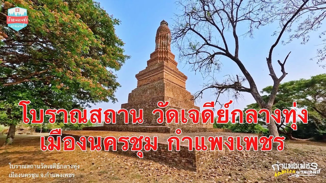
 Click to Access the Navigation Map GPS
Wat Chedi Klang Thung Map
Recommend

 Art, Culture and Heritage
 Historical Sites and Monuments(4)
 Landmarks and Memorials(1)
 Art, Craft Centres, Tradition(4)
 Museums(4)
 Historic Homes and Cities(1)
Temple(25)
Historic Homes and Cities(1)
Temple(25)
 Other Sacred Sites(8)
 Research and Development
 Royal Project(2)
 Suburban Living
 Village, Community(2)
 Local Market(2)
 Nature and Wildlife
 National Parks and Marine Reserves(4)
 Mountain (Doi)(2)
 Dam, Reservoir, Lake(4)
 Waterfalls(4)
 Hot Springs(1)
 River, Canal(3)
 Bays and Beaches(2)
 Other natural attractions(1)
 Entertainment and Agricultural
 Farms, Parks and Ecotourism(5)
 Waterpark(1)
 Shopping
 Shopping and Night Market(1)
 Travel Articles, Recipes
 Travel Review, Food Review(1)


