lovethailand home >North Travel Attractions >Tak Travel Attractions >Tha Song Yang >Tha Song Yang > Doi Thu Le
TL;DR: Doi Thu Le, Tak attractions : Nature and Wildlife, Mountain (Doi).

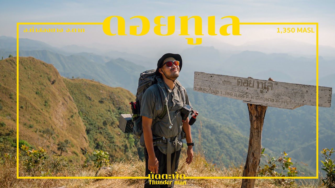
Doi Thu Le

Open Days: Contact the Doi Thu Le-Jawale community trekking group or Tha Song Yang Subdistrict Administrative Organization before visiting
Opening Hours: Advance registration and direct confirmation are required before the trip
Doi Thu Le in Tak Province is one of the most rewarding trekking destinations in Tha Song Yang District. Located around Ban Mae Chawang, Tha Song Yang Subdistrict, this mountain is known for its sea of mist, golden grassland, wild orchids, sunrise and sunset views, and the cultural landscape of a Karen community at the foot of the mountain. Doi Thu Le is not a drive-up viewpoint. It is a real trekking route that requires registration, local coordination, physical preparation, and respect for community-based tourism rules.
Doi Thu Le is located in Ban Mae Chawang, Tha Song Yang Subdistrict, Tha Song Yang District, Tak Province. The access point is near Highway 105 around kilometre 152+500. The name “Thu Le” comes from the Karen language and means “golden mountain,” a name that matches the appearance of the mountain during the cool and dry seasons when the grassland turns golden under the sunlight. This golden ridge scenery has become one of the most recognisable images of Doi Thu Le.
The main attraction of Doi Thu Le is the journey itself. Travelers cannot simply arrive, take a photo, and leave. They must begin from the community area, meet local coordinators or guides, and walk into the mountain landscape. The trek takes several hours and passes through forest, slopes, streams, grassland, and ridge areas. For many visitors, the sense of effort is part of the reward. Reaching the campsite after hours of walking makes the sunrise, sunset, and mist feel more meaningful.
Ban Mae Chawang is the gateway community to Doi Thu Le. The village is connected with Mae Chawang stream, forest resources, waterfalls, and highland landscapes. It is also a Karen community with a way of life shaped by mountains, water, farming, and forest knowledge. Visiting Doi Thu Le therefore gives travelers more than a scenic mountain experience. It also introduces them to the local community that helps manage access, guides visitors, supports porter services, and protects the trail.
Before trekking to Doi Thu Le, visitors should contact the Doi Thu Le-Jawale community trekking group or the local administrative organization to confirm the opening season, registration process, guide arrangement, porter availability, meeting point, and current safety requirements. Travelers should not attempt to walk independently without coordination because the area is a natural mountain route that requires local knowledge. Proper registration also helps manage visitor numbers and reduce environmental impact.
The journey usually begins in Tha Song Yang District using Highway 105. Travelers then continue toward Ban Mae Chawang according to the meeting point provided by local coordinators. Before entering the trail, visitors should prepare food, water, trekking gear, personal medication, and all necessary supplies because there are no ordinary shops or tourist services along the mountain trail. Careful preparation at the starting point is essential for a safe and comfortable trek.
The Doi Thu Le trekking route is varied. It starts near community and forest areas, then gradually climbs toward the ridge. Some sections are dirt trails, some are steep, and some pass through damp forest or stream areas. As the trail gains elevation, the landscape opens wider, showing mountain layers and forested slopes of Tha Song Yang District. This gradual transition from village to forest to ridge is one of the most memorable parts of the trek.
For beginner trekkers, Doi Thu Le should not be underestimated. The distance may not seem extremely long compared with some major trekking routes, but steep sections, heat, wind, backpack weight, and personal fitness can make the walk demanding. Travelers should exercise in advance, practice walking uphill and downhill, and pack only essential items. Every unnecessary kilogram becomes noticeable after several hours on a mountain trail.
The golden grassland is the signature image of Doi Thu Le. During the cool and dry seasons, the grass on the ridge turns yellow-gold, especially beautiful in the morning and evening light. When sunlight moves across the slope, the entire ridge appears warm and glowing. This scenery explains why the name “golden mountain” feels so appropriate and why many trekkers remember Doi Thu Le as one of the most atmospheric mountains in Tak Province.
In the early morning, Doi Thu Le is an excellent place to view sea mist. From November to February, the cool air and moisture in the valleys often create white mist below the ridge. As sunlight begins to rise, the mist slowly moves between mountain folds while the golden grass catches the first light. The combination of mist, ridge, grassland, and open sky creates a peaceful and powerful mountain scene.
Sunset is another highlight of the trek. After a long walk, many visitors sit quietly on the ridge and watch the sun descend behind the mountains. The colour of the grass changes with the light, shifting from gold to orange and then to muted brown as the sky darkens. This moment often becomes one of the strongest memories of the trip because it comes after real physical effort.
Doi Thu Le is also known for seasonal plants and wild orchids. Depending on the time of year, trekkers may encounter orchids, native grasses, forest plants, and changing vegetation along the route. The late rainy season offers fresh greenery and moist forest conditions, while the cool season brings clearer skies and golden grass. Each season gives the trail a different character, so repeat visitors may experience the mountain differently each time.
Camping on Doi Thu Le is a core part of the experience. Visitors sleep in tents among grassland and mountain scenery. There is no resort-style comfort on the ridge, but there is fresh air, silence, wind, and the feeling of being surrounded by nature. Travelers must bring or arrange tents, sleeping bags, mats, warm clothing, food, water, lights, and essential supplies. Porter services may be available through the local community depending on current arrangements.
Recommended equipment includes trekking shoes with good grip, breathable clothes for walking, warm clothes for night, a sleeping bag, headlamp, power bank, personal medication, blister plasters, waterproof bags, rubbish bags, and high-energy food that is not too heavy. Water planning is important and should follow the advice of local guides because water availability can vary by season and trail condition.
Responsible trekking is essential at Doi Thu Le. Visitors should carry all rubbish back down, avoid leaving food waste, avoid cutting plants, avoid picking wildflowers or orchids, keep noise low, and stay on the designated trail. A good trek should leave no visible damage behind. Doi Thu Le remains beautiful because the community, local coordinators, and responsible travelers help protect the route together.
The cultural context of Ban Mae Chawang adds meaning to the trip. The Karen community has long lived with the forest, streams, farming areas, and mountain resources. Travelers passing through the village should communicate politely, respect local ways of life, avoid photographing people without permission, and support community services when appropriate. Using local guides, porters, food services, or homestays helps distribute income to the community that helps maintain the route.
Doi Thu Le can be planned in different ways. A 2-day, 1-night itinerary is suitable for travelers focusing mainly on Doi Thu Le. Day 1 involves trekking from the community to the campsite, watching sunset, camping overnight, and waking early for mist and sunrise before descending. For travelers who want to connect the route with Doi Jawale or Mon Klui, a 3-day, 2-night itinerary or longer may be more suitable depending on local route management and visitor fitness.
The best time to visit Doi Thu Le is from November to February. The weather is cool, the sky is more likely to be clear, sea mist is common, and the golden grassland is at its most photogenic. The late rainy season offers green landscapes, but trails may be slippery and more demanding. During the dry season, visitors must follow fire-safety rules strictly because dry grassland can be vulnerable to wildfire.
For photography, Doi Thu Le offers wide mountain views, golden grassland, mist, sunset, sunrise, and trail atmosphere. A wide-angle lens is useful for landscapes, while a medium zoom helps capture mountain layers and mist movement. Photographers should carry extra batteries because cold weather may drain power faster. A waterproof bag or dry bag is useful for protecting cameras and phones from moisture.
Safety should always come first. Visitors should inform guides and companions about medical conditions, avoid walking too fast, stay with the group, and drink water regularly. If symptoms such as dizziness, cramps, knee pain, or unusual breathing occur, the guide should be informed immediately. Trekking is not a race. The goal is to reach the destination safely and still have enough energy to enjoy the mountain.
Doi Thu Le is a good example of community-based nature tourism. When visitors travel responsibly, income from guiding, porter services, and local support helps the community. At the same time, the trail and natural environment can remain protected. Choosing community-managed services and following local rules is one of the best ways to keep this trekking route sustainable.
Overall, Doi Thu Le is ideal for travelers who want to leave comfort behind and experience real mountain nature. It requires preparation, effort, and respect, but the reward is a memorable combination of sea mist, golden grass, wild orchids, open sky, local community, and the feeling of reaching a mountain through one’s own steps. For travelers seeking an adventurous natural destination in Tak Province, Doi Thu Le is one of the most meaningful routes to consider.
| Name | Doi Thu Le / Mon Thu Le |
| Location | Ban Mae Chawang, Tha Song Yang Subdistrict, Tha Song Yang District, Tak Province |
| Address | Ban Mae Chawang, Tha Song Yang Subdistrict, Tha Song Yang District, Tak 63150 |
| Coordinates / Reference Point | Ban Mae Chawang, Tha Song Yang Subdistrict, Tha Song Yang District, Tak Province; access point near Highway 105 around kilometre 152+500 |
| Highlights | Trekking route, sea of mist, golden grassland, wild orchids, sunrise, sunset, and Ban Mae Chawang community experience |
| History | A nature-based trekking destination in Tha Song Yang Subdistrict, connected with Ban Mae Chawang Karen community and the mountainous landscape of western Tak Province. |
| Name Origin | “Thu Le” is a Karen word meaning “golden mountain,” referring to the golden grassland on the ridge during the cool and dry seasons. |
| Distinctive Features | A mountain trekking route in Tha Song Yang with a campsite on the ridge, sea-mist viewpoints, golden grassland, and seasonal wild plants. |
| Travel Information | Use Highway 105 toward Tha Song Yang and Ban Mae Chawang, then register and coordinate with local route managers before starting the trek. |
| Current Status | A trekking route requiring advance contact and registration with local route managers. Visitors should check the current opening season and regulations before traveling. |
| Open Days | Contact the Doi Thu Le-Jawale community trekking group or Tha Song Yang Subdistrict Administrative Organization before visiting. |
| Opening Hours | Advance registration and direct confirmation are required before the trip. |
| Facilities | Registration point in Tha Song Yang area, local guide and porter services arranged by the community, mountain campsite, and basic services in the gateway village. |
| Main Areas / Zones | 1. Registration / Meeting Point in Tha Song Yang 2. Ban Mae Chawang 3. Doi Thu Le Trekking Trail 4. Mountain Camping Area 5. Sea-of-Mist Viewpoint 6. Sunrise and Sunset Viewpoints 7. Connecting Route to Doi Jawale / Mon Klui according to local route management |
| Caretaker / Area Authority | Doi Thu Le-Jawale community trekking group and Tha Song Yang Subdistrict Administrative Organization |
| Main Contact Number | Doi Thu Le registration Tel. 085-2670549 Numbers published by TAT: 055-577437, 089-2680119, 085-7054459, 080-1815820 |
| Official Website / Official Page | Doi Thu Le Facebook page and tourism information from Tha Song Yang Subdistrict Administrative Organization |
| Nearby Tourist Attractions | 1. Ban Mae Chawang, about 6 km from Tha Song Yang town area 2. Ban Mae Chawang Waterfall, about 1 km from Ban Mae Chawang 3. Doi Jawale, about 8 km on the community trekking route 4. Mon Klui / Klui Luang, about 10 km on the community trekking route 5. Mae Moei National Park, about 65 km from Ban Mae Chawang area |
| Nearby Restaurants | 1. Ban Mae Chawang community food services, about 6 km from Tha Song Yang town area 2. Cozy House Cafe & Bistro, Tha Song Yang, about 25 km, Tel. 092-575-7289 3. Krua Chaba Kaew, Tha Song Yang, about 25 km, Tel. 098-564-9466 4. New Mae Salit Guest House, about 35 km, Tel. 055-531409, 055-546121, 055-546122 5. Local restaurants and shops in Tha Song Yang town area, about 25 km |
| Nearby Accommodations | 1. Doi Thu Le Campsite, on Doi Thu Le route, contact route manager Tel. 085-2670549 2. Ban Mae Chawang Homestay / Community Stay, about 6 km from Tha Song Yang town area 3. New Mae Salit Guest House, about 35 km, Tel. 081-9715592 4. Wasan Guest House, Tha Song Yang, about 25 km, Tel. 082-8828292 5. Accommodation in Tha Song Yang town area, about 25 km |
Frequently Asked Questions (FAQ)
Q: Where is Doi Thu Le located?
A: Doi Thu Le is located around Ban Mae Chawang, Tha Song Yang Subdistrict, Tha Song Yang District, Tak Province.
Q: Who is Doi Thu Le suitable for?
A: It is suitable for trekkers, campers, nature photographers, and travelers who are physically ready for several hours of mountain walking.
Q: What does the name Doi Thu Le mean?
A: “Thu Le” is a Karen word meaning “golden mountain,” referring to the golden grassland on the ridge.
Q: Do visitors need to register before trekking to Doi Thu Le?
A: Yes. Visitors should contact and register with local route managers before the trip for guide, porter, and safety arrangements.
Q: When is the best time to visit Doi Thu Le?
A: November to February is the best period because the weather is cool, sea mist is more likely, and the golden grassland is beautiful.
Q: What should visitors prepare for Doi Thu Le?
A: Trekking shoes, warm clothes, tent, sleeping bag, flashlight, drinking water, food, personal medication, rubbish bags, and waterproof bags are recommended.
Q: How many days are recommended for Doi Thu Le?
A: A 2-day, 1-night trip is common for Doi Thu Le only. If connecting with Doi Jawale or Mon Klui, 3 days and 2 nights or longer may be more suitable.
![]() Category: ●Nature and Wildlife
Category: ●Nature and Wildlife
![]() Group: ●Mountain (Doi)
Group: ●Mountain (Doi)
Last Update : 1 MonthAgo
Doi Thu Le Map
Gellery
Recommend


