lovethailand home >North Travel Attractions >Chiang Mai Travel Attractions >Omkoi >Mon Chong > Doi Mon Chong Mountain
TL;DR: Doi Mon Chong Mountain, Chiang Mai attractions : Nature and Wildlife, Mountain (Doi).

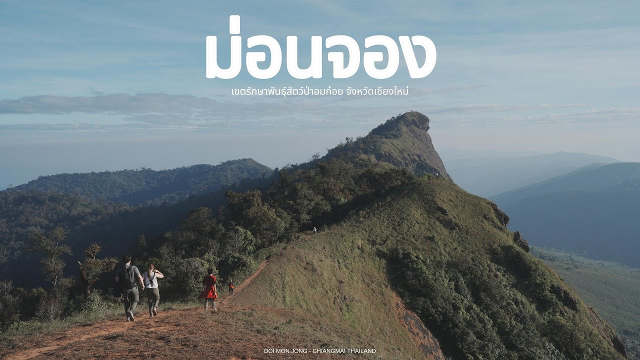
Doi Mon Chong Mountain

Open Days: Generally “seasonal” during November – February (based on announcements/reservations and management of Omkoi Wildlife Sanctuary; always check the latest status before traveling)
Opening Hours: No fixed opening–closing hours like city attractions (common practice is to check in at the coordination point before noon on the hiking day, and start early so you reach the campsite before dark)
Doi Mon Chong, often casually called “Mon Chong Mountain,” is a legendary trekking destination in southern Chiang Mai, within Omkoi Wildlife Sanctuary. What makes it special isn’t just the elevation or summit views, but the long layers of mountain ridges stretching to the horizon, the quiet of the forest that naturally slows you down, and the “chance to see an iconic wild animal” like the mainland serow (known among hikers as the “heavenly horse”). That alone is a big reason many people are willing to travel far and work hard to experience this place for themselves.
Doi Mon Chong lies inside Omkoi Wildlife Sanctuary, covering Omkoi District in Chiang Mai Province and connecting in parts to Sam Ngao District in Tak Province. The terrain here is rugged, mountainous forest; the weather changes quickly; and access conditions vary by season. That’s why “Mon Chong” is a route that requires real respect for site regulations, and it suits travelers who genuinely come to hike and learn from nature — not those looking for a quick photo stop.
The highlight most people talk about is the mainland serow, a rare wild animal that lives along cliffs and ridgelines. Sightings depend on timing and, honestly, how quiet you are. This isn’t a zoo — no one can guarantee you’ll see one. What you can do is improve your chances by walking quietly, not running, not playing music, not using drones, and not trying to “get closer for a sharper photo.” A sharper picture is never worth the risk of startling wildlife or altering natural behavior.
Another “prime window” is December to January, when you may see rhododendrons blooming along the ridges, plus crisp mountain air that makes sea-of-mist scenes and sunrise light look extra sharp. The tradeoff is real cold, especially if you camp for 1 night. Bring a jacket that truly works, a sleeping bag rated for low temperatures, and a windproof layer — because on some days the wind up on Mon Chong is strong enough that “standing still is freezing.”
For bird lovers, this area also has reports of rare species such as the white-bellied hawk-eagle, black-winged kite, booted eagle, white-bellied green pigeon, red-throated barbet, and the black-throated babbler, among others — depending on season and forest conditions. If you are serious about birding, having a local guide and hiking without rushing helps you “see more than you just pass by.”
A crucial point before planning is that Doi Mon Chong is a regulated tourism area. You must request permission and follow the rules of Omkoi Wildlife Sanctuary. In practice, travelers often coordinate through the Doi Mon Chong Tourist Service Center (community) to arrange permits, 4WD transfers, porters, and staff/local guides under the conditions set by the area. You should also confirm whether the trail is open for your travel dates, because some years it may close for restoration or due to weather-related safety concerns.
Getting There If starting from Chiang Mai city, the main route is Highway 108 (Chiang Mai–Chom Thong–Hot), then turn left at Hot District onto Highway 1099 toward Omkoi town. Continue along Highway 1099 for about 40 km to reach “Mu Se Unit,” a key coordination point for the sanctuary. From Mu Se Unit to the trailhead/community service center, some sections are narrow unpaved roads with cliffside curves, and generally “require a 4WD vehicle” with a highly experienced driver for safety.
If traveling by public bus, there is typically a route from Chang Phueak Gate in Chiang Mai city to Omkoi (times may change depending on the operating schedule). From Omkoi, you’ll need to coordinate a 4WD transfer locally. It’s best to buy your main supplies in Omkoi town because once you enter the unit/community zone, shops are limited and phone signal can be unreliable.
A “one-day round trip” hike is technically possible, but extremely demanding and requires a very early start (the general idea is at least 06:30). If you want a steadier pace with time to absorb the views, a 2 days 1 night plan is more suitable. It helps you manage time to reach the campsite before dark, set up camp, rest properly, and catch sunrise on the ridge without rushing.
Non-negotiable gear includes hiking shoes with strong grip, leech protection/insect repellent (especially late rainy season into early winter), a rain jacket that doesn’t balloon in wind, enough drinking water for stretches without refill points, easy-to-prepare trail food, a headlamp, a power bank, and your own trash bag. Many trekking-area rules emphasize “all trash must leave the forest” to avoid adding burden to the environment and the community.
For safety, Doi Mon Chong is a place where weather shifts fast, fog arrives quickly, and temperatures drop noticeably at night. Respecting turnaround times, hiking in a group, and following staff/guide instructions are essential. Don’t split off alone, don’t shortcut, and don’t “push for the summit” when conditions aren’t right — because in real wilderness, moving slower can be the safest choice.
From a “responsible travel” perspective, Mon Chong is a high-sensitivity wildlife area. Simple rules help immediately: don’t feed animals, keep noise down, don’t use drones, don’t leave food scraps/plastic behind, don’t pick flowers or plants, and don’t approach serows for photos. Small disturbances from visitors can become long-term impacts on wildlife behavior.
Lastly, if you ask who Mon Chong is for, the answer is: people who want a “real” trekking experience — real trails, real weather, real regulations — and who are willing to cooperate with the community and staff so tourism can coexist with nature without harming it. If you come with that mindset, Doi Mon Chong can leave a sharp, lasting memory — the views, the meaningful exhaustion, and a kind of quiet you won’t get from trips that end at a drive-up viewpoint.
| Place Name | Doi Mon Chong (Mon Chong Mountain) |
| Location | Omkoi Wildlife Sanctuary, Omkoi District, Chiang Mai Province (partly connected to Sam Ngao District, Tak Province) |
| Key Features | Mountain trekking with layered ridgelines, chance to spot mainland serow (“heavenly horse”), rhododendrons in Dec–Jan, and reported rare bird sightings (depending on season and conditions) |
| Nearby Attractions (With Distance) | Doi Mon Chong Tourist Service Center (Ban Mu Se entrance area) – 0 km, Tel. 092-559-7201 Omkoi Wildlife Sanctuary (coordinate via Ban Mu Se center) – 0 km, Tel. 093-731-0626 Ob Luang National Park (Hot District) – 120 km, Tel. 081-602-1290 Mae Ping National Park (Visitor Center) – 140 km, Tel. 0-5203-0380 Mae Tuen Wildlife Sanctuary (Tak Province) – 150 km, Tel. 055-577-441 |
| Nearby Restaurants (With Distance) | Krua Pijit (Omkoi) – 45 km, Tel. 085-232-1189 Aena ณ Omkoi – 45 km, Tel. 082-648-5778 good morning omkoi – 45 km, Tel. 098-950-4091 Ping Fai Cafe – 45 km, Tel. 098-952-3416 Omkoi Resort (Food/Stay) – 45 km, Tel. 086-188-1910 |
| Nearby Accommodations (With Distance) | Mon Chong Homestay (Ban Mu Se) – 5 km, Tel. 086-193-1399 Wan Wela Homestay & Camping – 45 km, Tel. 093-276-6287 Kade’ Homestay, Ban Na Kian – 70 km, Tel. 080-385-2146 Chalermphan Resort (Omkoi) – 45 km, Tel. 082-888-1919 Omkoi Resort – 45 km, Tel. 086-188-1910 |
Frequently Asked Questions (FAQ)
Q: Which months is Doi Mon Chong open?
A: It is generally seasonal during November–February, but you must follow the official announcements and reservation/management rules for the specific year before planning your trip.
Q: Do I need permission before hiking?
A: Yes. You must obtain permission and follow site regulations. It is recommended to coordinate through the Doi Mon Chong Tourist Service Center (community) to arrange permits, 4WD transfers, porters, and guides under the required conditions.
Q: Can I do it as a day trip?
A: Technically yes, but it is very exhausting and requires an extremely early start. If you want a more manageable pace and time to enjoy the scenery, a 2 days 1 night plan is usually better.
Q: When is the best chance to see rhododendrons?
A: Most commonly in December–January (depending on that year’s weather). Nights can be very cold, so bring proper cold-weather gear and a sleeping bag suitable for low temperatures.
Q: What should I do if I spot a serow?
A: Observe quietly from a safe distance. Do not approach, do not make loud noises, do not use flash/drones, and do not feed it — so wildlife behavior remains natural.
Tel : 053467109
![]() Category: ●Nature and Wildlife
Category: ●Nature and Wildlife
![]() Group: ●Mountain (Doi)
Group: ●Mountain (Doi)
Last Update : 7 MonthAgo
Doi Mon Chong Mountain Map
Gellery
Recommend


