
lovethailand home >North Travel Attractions >Chiang Mai Travel Attractions >Saraphi >Don Kaeo > Wat San Klang
TL;DR: Wat San Klang is located at Ban San Klang, Don Kaew Subdistrict, Saraphi District, Chiang Mai Province, open Daily, hours 08.00 – 17.00.
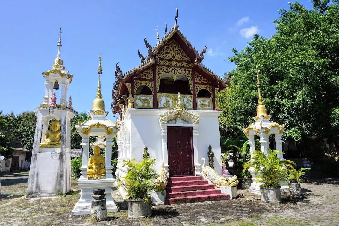
Wat San Klang
Open Days: Daily
Opening Hours: 08.00 – 17.00
Wat San Klang (Pa Tan) is located at No. 167, Ban San Klang, Rim Ping Road, Don Kaew Subdistrict, Saraphi District, Chiang Mai Province. It is a local Buddhist temple under the Mahanikaya sect and one of the historic community temples of Don Kaew. The temple was founded in B.E. 2417 and was originally known as Wat Rim Ping because it stood near the bank of the Ping River. Since the riverbank was repeatedly eroded by water, the temple was later moved to raised farmland in the middle of the village and rebuilt as Wat San Klang. It is also known locally as Wat Pa Tan.
The history of Wat San Klang is closely connected with the Ping River and the way local communities adapted to the landscape. The Ping River is one of Chiang Mai’s most important waterways, shaping agriculture, settlement, movement, and local culture for generations. At the same time, a temple located too close to the riverbank was vulnerable to erosion. The relocation of Wat Rim Ping to the center of the village shows how the community preserved its sacred space while adapting to environmental change.
The name Wat San Klang reflects the temple’s new location. In northern Thai usage, “san” often refers to raised ground or a ridge, while “klang” means central. The name therefore suggests a temple located on raised ground in the middle of the village. After the move from the riverbank, the temple became more accessible to residents and developed into the spiritual center of Ban San Klang.
The temple’s other name, Wat Pa Tan, preserves another layer of local memory. Village temple names in Lanna culture often refer to landscape, vegetation, water sources, or local stories. The presence of multiple names does not weaken the temple’s identity. Instead, it shows how the temple has been understood across time: first as a riverside temple, later as a temple at the village center, and also as a place associated with the older local landscape.
Don Kaew Subdistrict covers about 6.92 square kilometers, or approximately 4,325 rai. Its lowland environment is shaped by settlement, agriculture, irrigation channels, a main irrigation canal, and the Ping River. Wat San Klang therefore stands within a landscape where water, farmland, village roads, and temples are closely connected. This makes the temple a meaningful example of a Lanna village temple formed by both faith and geography.
Don Kaew Subdistrict consists of 7 villages: Ban Tamnak Nuea, Ban Tamnak Tai, Ban San Ton Kok, Ban Don Kaew Village No. 4, Ban Don Kaew Village No. 5, Ban Nam Cho, and Ban San Klang. Wat San Klang is one of the important Buddhist sites of the subdistrict, together with Wat Tamnak, Wat San Ton Kok, Wat Don Kaew, and Wat Nam Cho. These temples form a local temple network that reflects the traditional northern Thai pattern in which each village has a temple as a spiritual and social center.
Wat San Klang was founded in B.E. 2417 and received its royal consecrated boundary on August 31, B.E. 2486. The consecrated boundary measures 7.90 meters wide and 21 meters long. This boundary is significant because it formally designates the area for important Sangha rites. The temple therefore functions not only as a village place of worship but also as a complete Buddhist temple within the Mahanikaya monastic tradition.
The temple land covers 8 rai, 6 ngan, and 77 square wah under land title deed No. 19060. Its northern boundary adjoins a public irrigation channel, the southern boundary also adjoins a public irrigation channel, the eastern boundary adjoins villagers’ rice fields, and the western boundary adjoins a public irrigation channel. This setting clearly shows the relationship between the temple, irrigation system, and agricultural land.
The irrigation channels around the temple are important for understanding Wat San Klang. In Lanna communities, irrigation channels were not just waterways. They were part of agricultural life, village organization, and local cooperation. A temple surrounded by irrigation channels and rice fields stands at the center of both spiritual and everyday life. Visitors should therefore pay attention not only to the temple buildings but also to the landscape around the temple.
The important confirmed structures of Wat San Klang include a viharn, Tripitaka hall, monks’ residences, dining hall, and merit-making hall. The viharn serves as the main space for worship, sermons, and Buddhist ceremonies. The Tripitaka hall reflects the temple’s role in preserving Buddhist teachings and scriptures. The dining hall supports offerings to monks, while the merit-making hall serves community ceremonies and memorial activities.
The Tripitaka hall is especially meaningful because it represents the preservation of Buddhist learning. In a village temple, such a hall is not merely a storage building. It reflects respect for the Dhamma and the role of the temple as a place of knowledge, memory, and religious continuity. Wat San Klang therefore has both ceremonial and educational value within the community.
The most important sacred objects at Wat San Klang include a Chiang Saen-period bronze Buddha image and the Buddha image known as Phra Fon Saen Ha. A Chiang Saen-style Buddha image is important in northern Thai Buddhist art because it is associated with one of the great artistic traditions of the region. Its presence gives the temple cultural and artistic value for visitors interested in Lanna Buddhist heritage.
Phra Fon Saen Ha gives Wat San Klang another layer of meaning. The name of the image is associated with rain, abundance, and coolness. In a community surrounded by irrigation channels, rice fields, and the Ping River, a Buddha image with a name connected to rain naturally resonates with agricultural life and local belief. It reflects how Buddhist faith and the needs of a farming community can be expressed through sacred objects.
Wat San Klang remains an active religious site. Recent temple activity information identifies Phra Khru Wichian Panya as the abbot and records 5 resident monks. This confirms the temple’s continuing role as a living Buddhist community where monks and residents maintain merit-making activities, ceremonies, and local religious traditions.
Annual Buddhist activities associated with Wat San Klang include Buddhist holy days, Buddhist Lent, the end of Lent, Kathin, robe-offering events, memorial merit-making, and local village ceremonies. During major events, the temple becomes a space for cooperation. Residents gather to prepare offerings, cook food, listen to sermons, support the monks, and take part in shared community traditions.
Don Kaew Subdistrict also preserves local Lanna traditions such as Fon Phi Meng, Song Satong during the Northern Thai New Year period, the fourth lunar month Peng new rice merit-making tradition, the ninth northern lunar month tradition, candle processions for Buddhist Lent, and Loy Krathong. Temples in Don Kaew therefore support both Buddhist practice and the preservation of local cultural identity.
The atmosphere of Wat San Klang is peaceful and community-oriented. It is not a large commercial tourist temple. Its value lies in its story as a former riverside temple, its relocation to the center of the village, its sacred objects, and its relationship with irrigation channels and farmland. Visitors should begin at the viharn, pay respect to the important Buddha images, observe the Tripitaka hall, and take time to understand the surrounding landscape.
The main highlight of Wat San Klang is its history of movement from the Ping River to the heart of the village. This story makes the temple a cultural record of riverside life and environmental adaptation. When the temple moved inland, the spiritual center of the community moved with it. The name Wat San Klang therefore preserves both the new location and the temple’s role as the heart of Ban San Klang.
Wat San Klang is suitable for travelers interested in old temples in Chiang Mai, local temples in Saraphi, Lanna village history, riverside communities, and quieter cultural routes outside the main city temple circuit. Its value is not based on size or spectacle. It lies in the layered relationship between river, village, farmland, Buddhist art, and community faith.
A cultural route in Don Kaew Subdistrict can begin at Wat San Klang and continue to Wat Nam Cho, Wat Don Kaew, Wat San Ton Kok, and Wat Tamnak. Wat Nam Cho is known for Phra Kaew Chao Maha Chakkraphat Maha Setthi Than Chai and Burmese-Lanna artistic influence. Wat Don Kaew preserves a local story about an auspicious village gem, while Wat Tamnak is connected with Phraya Kawila. Visiting these temples together gives travelers a broader understanding of Don Kaew’s local temple network.
Travelers can also extend the route to Wiang Kum Kam and the Chiang Mai–Lamphun rubber tree road. Wiang Kum Kam adds an important Lanna historical dimension, while the tree-lined road is one of the most memorable landscapes of Saraphi. Combining Wat San Klang with nearby temples, Wiang Kum Kam, and the rubber tree road creates a balanced cultural itinerary of river, village, temple, and history.
Getting There is easiest by private car, rental car, motorbike, taxi, or ride-hailing service from Chiang Mai city. Travel south toward Saraphi District, enter Don Kaew Subdistrict, and continue to Ban San Klang. The temple is located within a community area, so visitors without their own vehicle should arrange a return trip or hire a vehicle for several hours if they plan to visit nearby temples, restaurants, and accommodations.
The best time to visit is in the morning or late afternoon when the weather is more comfortable and the temple atmosphere is peaceful. During Buddhist festivals such as Kathin, robe-offering events, Buddhist Lent, and village ceremonies, the temple may become livelier with community participation. Visitors seeking a quiet visit should choose a weekday outside major ceremonies.
Visitors should follow standard Thai temple etiquette: dress modestly, speak softly, remove shoes where required, avoid entering private monastic areas, do not disturb ceremonies, and ask permission before taking close-up photos of people or religious activities. Respectful behavior is especially important because this is an active village temple and a living religious space for the local community.
In summary, Wat San Klang (Pa Tan) is a historic community temple in Ban San Klang, Don Kaew Subdistrict, Saraphi District, Chiang Mai. Founded in B.E. 2417, it was formerly known as Wat Rim Ping before being moved from the Ping River bank to raised land in the center of the village. The temple preserves important structures such as a viharn, Tripitaka hall, monks’ residences, dining hall, and merit-making hall, along with important sacred objects including a Chiang Saen-period bronze Buddha image and Phra Fon Saen Ha. It is a meaningful stop for travelers who want to understand local Lanna Buddhism, village history, and the quieter cultural side of Saraphi.
| Name | Wat San Klang (Pa Tan) |
| Location | Ban San Klang, Don Kaew Subdistrict, Saraphi District, Chiang Mai Province |
| Address | No. 167, Ban San Klang, Rim Ping Road, Don Kaew Subdistrict, Saraphi District, Chiang Mai 50140, Thailand |
| Coordinates | 18.69445, 98.9908 |
| Temple Type | Local Buddhist temple under the Mahanikaya sect |
| Temple Code | 350190904 |
| Area | 8 rai, 6 ngan, 77 square wah |
| Land Title Deed | No. 19060 |
| Boundaries | North: adjoining a public irrigation channel South: adjoining a public irrigation channel East: adjoining villagers’ rice fields West: adjoining a public irrigation channel |
| Highlights | Historic temple formerly known as Wat Rim Ping, later moved from the Ping River bank to raised land in the center of the village; important sacred objects include a Chiang Saen-period bronze Buddha image and Phra Fon Saen Ha |
| History | Founded in B.E. 2417; originally known as Wat Rim Ping and later rebuilt as Wat San Klang or Wat Pa Tan after riverbank erosion made the old location unsuitable |
| Former Name | Wat Rim Ping |
| Alternative Name | Wat Pa Tan |
| Name Origin | The former name came from the original riverside location near the Ping River, while the current name refers to the temple’s relocation to raised land in the village center |
| Consecrated Boundary | Granted on August 31, B.E. 2486; 7.90 meters wide and 21 meters long |
| Community Context | Located in Ban San Klang, one of the 7 villages of Don Kaew Subdistrict, a lowland area shaped by the Ping River, irrigation channels, farming land, and village settlement |
| Distinctive Features | A local Lanna village temple connected with the Ping River, irrigation channels, rice fields, and the relocation of a riverside temple into the village center |
| Important Zones And Structures | Viharn Tripitaka Hall Monks’ Residences Dining Hall Merit-Making Hall Temple Grounds And Community Religious Activity Area |
| Sacred Objects | Chiang Saen-period bronze Buddha image and Phra Fon Saen Ha |
| Important Ceremonies | Kathin, robe-offering events, Buddhist Lent, the end of Lent, Buddhist holy days, memorial merit-making, and annual community ceremonies |
| Travel Information | Accessible from Chiang Mai city toward Saraphi District, then Don Kaew Subdistrict and Ban San Klang; best reached by private car, rental car, motorbike, taxi, or ride-hailing service |
| Current Status | Open as an active community temple used for Buddhist ceremonies, merit-making, and local village activities |
| Open Days | Daily |
| Opening Hours | 08.00 – 17.00 |
| Abbot / Caretaker | Phra Khru Wichian Panya |
| Resident Monks | 5 monks |
| Nearby Tourist Attractions | 1. Wat Nam Cho, about 2 km 2. Wat Don Kaew, about 3 km 3. Wat San Ton Kok, about 4 km 4. Wat Tamnak, about 5 km 5. Wiang Kum Kam, about 9 km 6. Chiang Mai–Lamphun Rubber Tree Road, about 10 km |
| Nearby Restaurants | 1. The Garage FOODS & COFFEE Don Kaew-Saraphi, about 2 km, Tel. 097-198-9968 2. BBQ Na 7 Don Kaew Saraphi, about 2 km, Tel. 092-329-4508 3. Zaeb Nua In Front Of Wat Nam Cho, about 2 km, Tel. 097-283-0973 4. MEE Cafe Sansai San Sai Noi, about 3 km, Tel. 096-313-0625 5. Por Pla Pao Don Kaew Plaza, about 4 km, Tel. 091-480-4838 |
| Nearby Accommodations | 1. Parichai Home Stay, about 3 km, Tel. 081-602-4425 2. Lang Suan Resort Saraphi, about 4 km, Tel. 093-469-3555 3. Chiang Mai Garden Bungalows, about 5 km, Tel. 083-272-6681 4. Patarada Boutique House, about 5 km, Tel. 081-885-2513 5. Relax Garden House, about 6 km, Tel. 090-326-6108 |
Frequently Asked Questions (FAQ)
Q: Where is Wat San Klang (Pa Tan) located?
A: Wat San Klang is located at No. 167, Ban San Klang, Rim Ping Road, Don Kaew Subdistrict, Saraphi District, Chiang Mai Province 50140.
Q: What are the opening days and hours of Wat San Klang?
A: The temple is open daily from 08.00 to 17.00.
Q: Why is Wat San Klang historically important?
A: Wat San Klang was founded in B.E. 2417. It was originally known as Wat Rim Ping because it stood near the Ping River before being moved to raised land in the center of the village due to riverbank erosion.
Q: When did Wat San Klang receive its royal consecrated boundary?
A: Wat San Klang received its royal consecrated boundary on August 31, B.E. 2486. The boundary measures 7.90 meters wide and 21 meters long.
Q: What important structures are found at Wat San Klang?
A: Important structures include a viharn, Tripitaka hall, monks’ residences, dining hall, and merit-making hall.
Q: What sacred objects are important at Wat San Klang?
A: Important sacred objects include a Chiang Saen-period bronze Buddha image and Phra Fon Saen Ha.
Q: What is the main highlight of Wat San Klang?
A: Its main highlight is the story of relocation from the Ping River bank into the village center, together with its relationship with irrigation channels, rice fields, and important old Buddha images.
Q: What nearby places can be visited with Wat San Klang?
A: Nearby places include Wat Nam Cho, Wat Don Kaew, Wat San Ton Kok, Wat Tamnak, Wiang Kum Kam, and the Chiang Mai–Lamphun rubber tree road.
 Category: ●Places of Worship
 Group: ●Temple
Last Update : 2 WeekAgo
 Last Update : 2 WeekAgo
 Click to Access the Navigation Map GPS
 Muang Chiang Mai(121)Chom Thong(47)Mae Chaem(25)Chiang Dao(33)Doi Saket(68)Mae Taeng(85)Mae Rim(69)Samoeng(29)Fang(71)Mae Ai(59)Phrao(70)San Pa Tong(103)San Kamphaeng(66)San Sai(73)Hang Dong(73)Hot(32)Doi Tao(22)Omkoi(11)Saraphi(74)Wiang Haeng(15)Chai Prakan(28)Mae Wang(32)Mae On(22)Doi Lo(33)Galyani Vadhana(1)


