
lovethailand home >North Travel Attractions >Chiang Mai Travel Attractions >Mae On >Huai Kaeo > Wat Mae Lai
TL;DR: Wat Mae Lai is located at Moo 2, Ban Mae Lai, Huai Kaeo, Mae On District, Chiang Mai 50130, Thailand. is a community Buddhist temple in Moo 2, Ban Mae Lai, Huai Kaeo Subdistrict, Mae On District, Chiang Mai 50130. It is a Mahanikaya temple.
Wat Mae Lai
Operating day: Daily
Operating time: 08.00 - 17.00
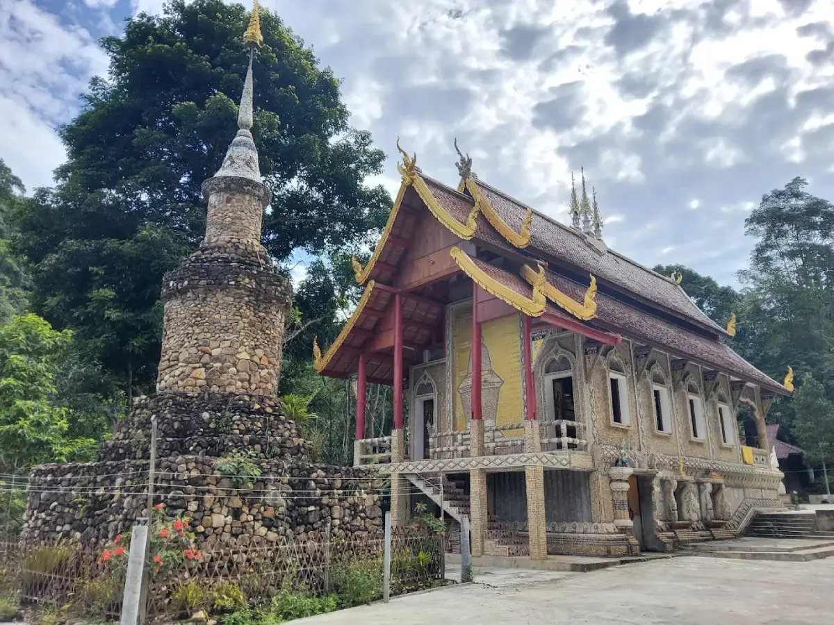
Wat Mae Lai is a community Buddhist temple in Moo 2, Ban Mae Lai, Huai Kaeo Subdistrict, Mae On District, Chiang Mai 50130. It is a Mahanikaya temple registered under code 350230406 and was established in 1937. For nearly nine decades, the monastery has served as the spiritual center of Ban Mae Lai while developing a distinctive architectural identity based on the landscape surrounding it. River stones from the Mae Lai stream have been used to decorate the ubosot, viharn, stupa, gateways, columns, stair railings and other sacred structures, creating one of the most recognizable temple styles in this part of Mae On. The temple also contains a principal Buddha image, a stone-decorated stupa and the locally revered Phra Chao Than Chai. Surrounded by mountain forest, miang tea gardens, coffee farms and the stream that gives the village its name, Wat Mae Lai offers a direct connection between Buddhist faith, Lanna community life and the natural environment.
Wat Mae Lai is the village temple of Ban Mae Lai, Moo 2, one of the eight communities within Huai Kaeo Subdistrict. The village lies among interlocking mountains east of Chiang Mai, surrounded by an extensive watershed landscape. Hills, forested valleys and flowing streams shape both the settlement pattern and local livelihoods. Houses follow the mountain road and waterways, while the humid forest environment keeps temperatures noticeably cooler than the Chiang Mai lowlands during much of the year. The temple's relatively small scale and green surroundings therefore fit naturally into the landscape rather than dominating it.
The history of Ban Mae Lai predates the temple by several generations. Cultural records describe Khmu people and settlers from Chae Hom District in Lampang as among the earlier groups to live and work in the area. Some later moved elsewhere, while northern Thai settlers from Doi Saket gradually established a more permanent community. The village took the name “Mae Lai” from the stream that flows through the settlement and has supported everyday life and agriculture for generations.
Ban Mae Lai covers approximately 2,500 rai and consists largely of rolling slopes, hills and mountain terrain surrounded by the Mae On forest landscape. The Mae Lai stream is one of the village's most important natural resources, providing water for households, miang tea gardens, coffee cultivation and other agricultural activities. Its importance extends beyond livelihood: stones from the same watercourse later became one of the defining materials used in Wat Mae Lai's religious architecture.
Wat Mae Lai was created in 1937 under the leadership of Kruba Som, who worked with village residents to establish a Buddhist center of their own. Early temple records identify land donated by Ban Tevabut for the monastery. Establishing a temple in a remote mountain settlement required significant community cooperation because modern roads and construction logistics did not yet exist in the form travelers see today.
Historical temple documentation records construction beginning in 1937, followed by formal establishment on 6 February 1938. The monastery developed during the same period in which Ban Mae Lai was becoming a more permanent and organized settlement. A local temple meant that residents no longer needed to travel long distances through mountain terrain for Buddhist ceremonies, sermons and merit-making.
Historical abbot records show several generations of monks caring for the monastery, beginning with Kruba Som and continuing through Phra Kaeo, Kruba Inta, Phra Som, Phra Kong, Phra Phut, Phra Ae, Phra Kham Silasivaro and later monastic leaders. More recent temple information identifies Phra Phochat Analayo as abbot. This long succession demonstrates that Wat Mae Lai is not simply an architectural landmark but a religious institution sustained by generations of monks and villagers.
Older temple records mention a prayer hall and monks' residences among the early monastic structures. The temple has changed and developed considerably since those records were compiled, most visibly through the use of river stones in the ubosot, viharn and stupa. Rather than weakening the temple's local character, these later developments strengthened the connection between the monastery and the landscape of Ban Mae Lai.
The most distinctive feature is the use of stones from the Mae Lai stream. Individual stones vary in shape, color and texture, producing surfaces that cannot be reproduced uniformly. Their significance comes from more than appearance. They originated in the waterway that supports the village, and local residents brought stones as offerings for the construction and decoration of Buddhist structures.
The ubosot provides one of the clearest examples. River stones decorate gateways, columns, railings and surrounding surfaces, giving the ordination hall a character unlike conventional plaster temples. From close range, visitors can see the irregularity of individual stones; from farther away, the separate pieces merge into a unified architectural pattern.
Parts of the ubosot also incorporate representations of the twelve zodiac animals. These details add another cultural layer to the architecture and reflect northern Thai traditions in which birth years and animal cycles remain familiar elements of identity and belief.
Inside the ubosot, the principal Buddha image forms the focus of worship. Stone decoration continues into the interior, connecting the outer architecture with the sacred space within. Visitors should remove their shoes where required, keep voices low and allow priority to worshippers.
The viharn is another major structure decorated with Mae Lai river stones. In a Lanna community temple, the viharn traditionally plays an especially important role for laypeople, providing space for worship, sermons and religious gatherings. Its stone decoration therefore represents more than ornamental design; it expresses the community's direct participation in the building it continues to use.
The stone-decorated stupa is another defining landmark. Villagers contributed stones that were incorporated into the structure, creating an appearance very different from the gilded or whitewashed stupas more commonly associated with northern Thai temples. The result visually connects a Buddhist sacred monument with the geography of the village.
The community effort behind the stone architecture is central to its meaning. Collecting, moving, selecting and arranging large numbers of stones required sustained cooperation. Each stone can therefore be understood not simply as a construction material but as a small element in a collective act of merit-making.
Ban Mae Lai is also associated with the revered Phra Chao Than Chai. Within Lanna devotional culture, Than Chai Buddha images are commonly connected with prayers for success and the fulfillment of sincere wishes. Visitors therefore come not only to examine the unusual architecture but also to worship and make merit.
The temple's natural setting reinforces the experience. The Mae Lai stream runs through the mountain community throughout the year, supporting a humid environment in which mosses, ferns and forest plants thrive. Combined with the river-stone architecture, this gives Wat Mae Lai an appearance deeply integrated into its surroundings.
Ban Mae Lai borders Ban Pok to the north, Mae Kampong to the south, mountainous terrain toward Lampang to the east and Ban Tharnthong to the west. The village therefore sits within a network of highland communities while maintaining a quieter rhythm than heavily visited Mae Kampong.
Traditional livelihoods have long centered on miang tea gardens. Fermented tea leaves known as miang are an important part of northern Thai food culture and were historically a major cash crop in mountain communities around Chiang Mai. Mae Lai's humid forest and cooler elevation created suitable conditions for tea cultivation.
Coffee later became another important crop. Arabica coffee grown in shaded highland conditions provides additional income, while cafés and homestays have incorporated local coffee culture into the modern visitor economy.
Residents have also practiced other livelihoods including broom making, preserved bamboo-shoot production and composting. The range of economic activities shows that Ban Mae Lai remains more than a tourism village. Agriculture, forest resources and household production continue to matter.
Ban Mae Lai also appears within Chiang Mai's community-forest network. The forest is not merely scenic background; it protects the watershed, supports biodiversity and maintains the cool, moist conditions required by tea, coffee and village water systems.
The importance of water becomes especially clear at Mae Lai Waterfall, located roughly two kilometres above the village area. Water from the upper watershed moves through the waterfall, forest and agricultural landscape before continuing into the settlement.
The waterfall includes multiple natural levels surrounded by mountain forest. The route passes through areas associated with coffee gardens and woodland. The rainy season and early cool season bring the greenest conditions, although wet rocks and paths require greater care.
Wat Mae Lai therefore functions as an effective introduction to the village. Starting with the temple and then walking or driving toward the stream, gardens and waterfall allows visitors to understand how the community fits together. The stones in the monastery come from the water, the water comes from the forest, and the forest supports the agriculture on which generations of residents have depended.
This relationship gives the temple meaning that cannot be separated from its location. If the stone architecture were removed from Mae Lai and rebuilt elsewhere, part of its story would immediately disappear. Its significance depends on the connection among river stone, community faith and the mountain settlement itself.
Wat Mae Lai has increasingly appeared in Mae On cultural tourism routes, particularly for its river-stone architecture. Chiang Mai tourism networks have presented the temple alongside caves, Buddhist sites, hot springs and other district attractions, bringing greater attention to a monastery that remains modest in scale.
Visitors should begin by paying respect to the principal Buddha image and then examine the stone details of the ubosot and viharn. The zodiac motifs, gateways, columns and railings reward close observation. The stone stupa and Phra Chao Than Chai can then be visited before exploring the surrounding community.
Although tourism has increased, Wat Mae Lai remains a working Buddhist temple. Visitors should cover shoulders and knees, remove shoes where indicated, speak quietly and avoid climbing or touching stone decorations unnecessarily.
Photography is appropriate in public areas when it does not interfere with worship. During ceremonies or sermons, visitors should give priority to residents and monks. Images that include the temple, forest and water convey the character of Mae Lai particularly well.
Morning is one of the best periods to visit. Temperatures are cool, the village is relatively quiet and soft light reveals the texture of the stone architecture. The rainy season offers especially vivid greenery, while the cool season is ideal for an overnight stay.
Mae Lai lies close to Mae Kampong but offers a noticeably different visitor experience. Mae Kampong has a dense concentration of restaurants, cafés and day visitors, while Mae Lai remains quieter, with accommodation and cafés dispersed along the stream and mountain road.
Teen Tok Royal Project Development Center is easy to combine with the temple. The center played an important role in diversifying highland agriculture through Arabica coffee, shiitake mushrooms and other crops, providing useful context for the economic transformation of Huai Kaeo.
Pha Nam Lod is another nearby nature stop characterized by forest, rock and flowing water. It can be visited before continuing toward Mae Kampong, allowing travelers to combine cultural and environmental attractions within a compact mountain area.
Wat Khantha Phueksa, commonly known as Wat Mae Kampong, provides an interesting comparison. Wat Mae Kampong is known for its wooden viharn and stream-surrounded ordination hall, while Wat Mae Lai is distinguished by extensive river-stone decoration. Visiting both demonstrates how neighboring highland communities developed different forms of religious architecture using their natural surroundings.
Mae Kampong Village lies only a few kilometres farther along the mountain route. Travelers can visit Wat Mae Lai in the morning, eat or drink coffee in Mae Lai and continue to Mae Kampong later in the day, or reverse the route.
Staying overnight in Mae Lai offers a quieter experience after day visitors have left the broader mountain corridor. Evening is dominated by the sound of water, while early morning provides an opportunity to visit the temple before traveling onward.
Baan Pak Plern & Pa Noi Lung Chu is one of the closest accommodations to the temple and sits within Moo 2. Other local options include Ban Rabieng Doi and Shinrin-yoku Chiang Mai, both within the Mae Lai community.
The Lai Tiny House and Taloh Homestay Chiang Mai provide additional small-scale accommodation within Huai Kaeo. Choosing accommodation within or near Moo 2 reduces the need to drive repeatedly along narrow mountain roads.
Food and café options also reflect the streamside atmosphere. Claai Cafe & Eatery is a riverside café in Ban Mae Lai, while Atlantis Valley occupies a forested, multi-level setting with a stream running through the property.
Kampor is another small café in the Mae Lai area, while Baan Pak Plern has provided both accommodation and food. Additional cafés and restaurants are available farther along the road toward Mae Kampong and Ban Pok.
Getting There from Chiang Mai city is easiest via San Kamphaeng and Mae On. Follow the main route toward Huai Kaeo and Mae Kampong. Near Teen Tok Royal Project Development Center, take the branch road toward Ban Mae Lai and continue into Moo 2. Searching for “Wat Mae Lai, Huai Kaeo, Mae On” helps identify the correct temple.
The temple is located at approximately 18.88103, 99.34939 and an elevation of around 928 metres. The approach road includes mountain curves and gradients, so drivers should reduce speed, particularly in rain or fog.
Ban Mae Lai is approximately 50 kilometres from central Chiang Mai, depending on the starting point. Private car, rental car or hired driver is the most practical option for travelers planning to visit multiple attractions.
Roads inside the village can be narrow, with homes, accommodation and cafés positioned close to the route. Visitors should avoid blocking household entrances and should use designated parking whenever possible.
The rainy season brings the deepest green scenery and stronger stream flow, but also slippery surfaces. The cool season offers comfortable temperatures and is particularly suitable for overnight stays. During warmer months, morning visits are generally the most pleasant.
Families can use the temple as an accessible cultural stop before continuing to the Royal Project or waterfall. Older travelers should take care on wet or uneven surfaces, although visiting the main temple area does not require a long mountain hike.
Architecture enthusiasts should allow at least forty-five minutes to one hour. Important details appear on gateways, pillars, railings, zodiac decorations, the stupa and interior surfaces rather than only in the overall outline of the buildings.
Visitors interested in community life should also walk through Ban Mae Lai. Wooden houses, gardens, streams, cafés and accommodation appear throughout the settlement. Respect for private land and residential space is essential.
Wat Mae Lai can also be connected with other temples in Huai Kaeo, including Wat Khantha Phueksa, Wat Ban Pok, Wat Mae Tao Din and Wat Huai Kaeo. Each reflects the history and landscape of a different village.
A practical half-day route combines Wat Mae Lai, Ban Mae Lai, Teen Tok Royal Project Development Center and Pha Nam Lod. A full day can add Mae Lai Waterfall, Wat Khantha Phueksa and Mae Kampong Village.
The temple's greatest strength is not monumental size but the fact that nearly every architectural element can be connected back to the surrounding landscape. River stones speak of the stream and watershed; the viharn and ubosot represent village faith; the stupa reflects collective merit; and surrounding tea and coffee gardens reveal the economic life of the community.
From 1937 to 2026, Wat Mae Lai has witnessed approximately eighty-nine years of change. Roads, vehicles, homestays, cafés and tourism have transformed the mountain corridor, yet the monastery continues to express the relationship between local residents and Buddhist life.
Wat Mae Lai is therefore particularly suitable for travelers who want to combine Buddhist worship with community and environmental learning. Its stone architecture, miang tea culture, coffee farms, watershed forest and proximity to Mae Kampong make it an unusually complete cultural stop within Mae On.
Today, Wat Mae Lai remains both the village's Buddhist center and a distinctive work of locally rooted religious art. The ubosot, viharn, stone stupa, principal Buddha image, Phra Chao Than Chai and zodiac details provide multiple points of interest, while the Mae Lai stream, forest, tea gardens and mountain community give those sacred structures their wider meaning.
| Name | Wat Mae Lai |
| Type | Community Buddhist Temple, Mahanikaya Order |
| Temple Code | 350230406 |
| Location | Moo 2, Ban Mae Lai, Huai Kaeo, Mae On District, Chiang Mai 50130, Thailand |
| Coordinates | Approximately 18.88103, 99.34939 |
| Elevation | Approximately 928 metres above sea level |
| Established | 1937 |
| Temple Age | Approximately 89 years in 2026 |
| Founding Figure | Kruba Som and the Ban Mae Lai community, on land donated for the monastery by Ban Tevabut |
| Abbot | Phra Phochat Analayo |
| Main Highlight | Ubosot, viharn and stupa decorated with stones from the Mae Lai stream |
| Ubosot | River-stone decoration on gateways, columns, railings and walls, including zodiac motifs |
| Viharn | Community worship hall incorporating Mae Lai river stones into its decorative design |
| Stupa | Stone-decorated stupa created through community faith and donated river stones |
| Main Sacred Features | Principal Buddha image, stone stupa and Phra Chao Than Chai |
| Community Role | Village Buddhist center and spiritual focus of Ban Mae Lai |
| Traditional Livelihoods | Miang tea gardens, coffee cultivation, agriculture, broom making, preserved bamboo shoots and compost production |
| Natural Resources | Mae Lai stream, watershed forest, miang tea gardens, coffee farms and community forest |
| Getting There | From Chiang Mai, travel through San Kamphaeng and Mae On toward Huai Kaeo and Mae Kampong, then take the Ban Mae Lai branch near Teen Tok Royal Project Development Center. |
| Current Status | Active village Buddhist temple listed in the current temple register |
| Nearby Attractions | 1. Teen Tok Royal Project Development Center – about 1 km 2. Pha Nam Lod – about 1 km 3. Mae Lai Waterfall – about 2 km 4. Wat Khantha Phueksa / Wat Mae Kampong – about 4 km 5. Mae Kampong Village – about 5 km |
| Nearby Restaurants And Cafés | 1. Baan Pak Plern / Kin Plern – about 0.3 km, Tel. 083-263-5332 2. Claai Cafe & Eatery – about 0.5 km, Tel. 081-111-7841 3. Kampor – about 0.5 km, Tel. 065-367-6483 4. Atlantis Valley – about 1 km, Tel. 092-463-5428 5. The Giant Chiangmai – about 5 km, Tel. 086-776-2946 |
| Nearby Accommodations | 1. Baan Pak Plern & Pa Noi Lung Chu – about 0.3 km, Tel. 083-263-5332 2. Ban Rabieng Doi – about 0.5 km, Tel. 063-291-5844 3. Shinrin-yoku Chiang Mai – about 1 km, Tel. 098-376-4816 4. The Lai Tiny House – about 2 km, Tel. 080-605-5992 5. Taloh Homestay Chiang Mai – about 2 km, Tel. 095-748-7419 |
Frequently Asked Questions (FAQ)
Q: Where is Wat Mae Lai?
A: Wat Mae Lai is in Moo 2, Ban Mae Lai, Huai Kaeo Subdistrict, Mae On District, Chiang Mai 50130. Its approximate coordinates are 18.88103, 99.34939.
Q: When was Wat Mae Lai established?
A: Wat Mae Lai was established in 1937 under the leadership of Kruba Som and Ban Mae Lai residents, with land donated for the village monastery.
Q: What is the main highlight of Wat Mae Lai?
A: The temple is best known for using stones from the Mae Lai stream to decorate the ubosot, viharn, stupa, gateways, columns and railings, creating architecture closely connected with the village landscape.
Q: What can visitors worship at Wat Mae Lai?
A: Important sacred features include the principal Buddha image, the stone-decorated stupa and Phra Chao Than Chai. Visitors can also examine the zodiac motifs and extensive river-stone decoration.
Q: Why is Wat Mae Lai important to the village?
A: It has served as Ban Mae Lai's community temple and spiritual center since 1937. The use of stones from the village stream further connects the monastery with the natural and cultural identity of the community.
Q: How do I get to Wat Mae Lai?
A: From Chiang Mai, travel through San Kamphaeng and Mae On toward Huai Kaeo and Mae Kampong. Near Teen Tok Royal Project Development Center, take the branch road toward Ban Mae Lai and continue into Moo 2.
Q: Is Wat Mae Lai close to Mae Kampong?
A: Yes. Wat Mae Lai, Ban Mae Lai, Wat Khantha Phueksa and Mae Kampong Village can easily be combined within the same mountain itinerary.
Q: What should I visit after Wat Mae Lai?
A: Nearby options include Mae Lai Waterfall, Teen Tok Royal Project Development Center, Pha Nam Lod, Wat Khantha Phueksa and Mae Kampong Village. Staying overnight in Mae Lai or Huai Kaeo allows a more relaxed itinerary.
 Category: ●Places of Worship
 Group: ●Temple
Last Update : 22 HourAgo
 Last Update : 22 HourAgo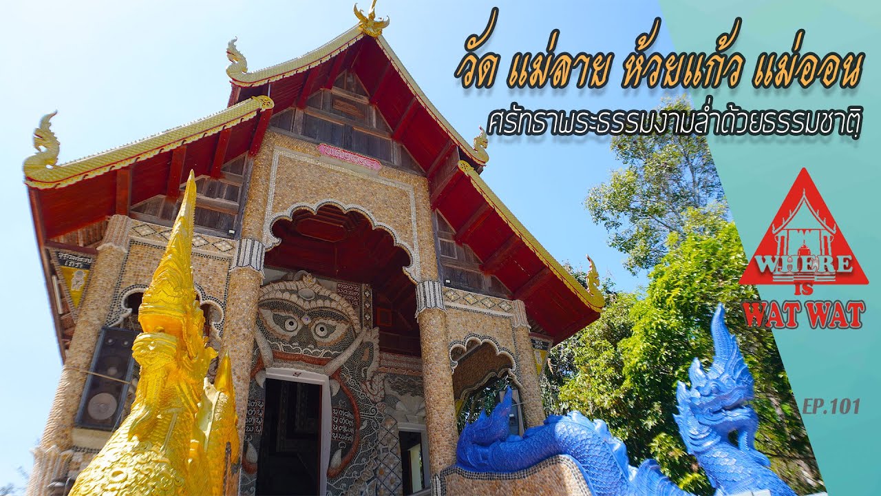
 Click to Access the Navigation Map GPS
Wat Mae Lai Map
Recommend

 Muang Chiang Mai(121)Chom Thong(47)Mae Chaem(25)Chiang Dao(33)Doi Saket(68)Mae Taeng(85)Mae Rim(69)Samoeng(29)Fang(71)Mae Ai(59)Phrao(70)San Pa Tong(103)San Kamphaeng(66)San Sai(73)Hang Dong(73)Hot(32)Doi Tao(22)Omkoi(11)Saraphi(74)Wiang Haeng(15)Chai Prakan(28)Mae Wang(32)Mae On(22)Doi Lo(34)Galyani Vadhana(1)


