
lovethailand home >North Travel Attractions >Chiang Mai Travel Attractions >Chom Thong >Khuang Pao > Wat Mai San Tueng
TL;DR: Wat Mai San Tueng is located at Ban Mai San Tueng, Moo 8, Khuang Pao Subdistrict, Chom Thong District, Chiang Mai Province, open Daily, hours Daytime visits are recommended.
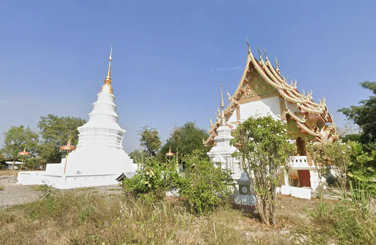
Wat Mai San Tueng
Open Days: Daily
Opening Hours: Daytime visits are recommended
Wat Mai San Tueng is located at 139 Ban Mai San Tueng, Moo 8, Khuang Pao Subdistrict, Chom Thong District, Chiang Mai Province. It is a Mahanikaya local Buddhist temple that plays an important role in the religious and community life of Ban Mai San Tueng. The temple received permission for construction on 11 May 1984 and was officially established as a temple on 11 November 1987. Its origin reflects the collective faith of local villagers who needed a temple closer to home because traveling to the temple they regularly supported was inconvenient.
Wat Mai San Tueng is best understood as a living community temple rather than a large tourist landmark. Its value lies in the way it grew from local necessity, donated land, village cooperation, and Buddhist faith. The temple provides a place for merit-making, Dhamma listening, community ceremonies, and seasonal Buddhist activities. It is a meaningful stop for travelers who want to see how village temples continue to support everyday religious life in Chom Thong District.
Ban Mai San Tueng is Moo 8 of Khuang Pao Subdistrict, an area in the northern part of Chom Thong District. The subdistrict is connected by Highway 108, the Chiang Mai-Hot road, and is also close to routes leading toward Doi Inthanon, Mae Klang Waterfall, and other natural attractions. This makes Wat Mai San Tueng suitable for travelers who want to combine local temple visits with the Doi Inthanon route.
The temple’s founding history is closely connected with local generosity. The land for the temple was donated by Nai Tip Ruean Fa and Nang Kham Ruean Fa, while Nai Chatchawet Sai Chana applied for permission to construct and establish the temple. The reason for building the temple was that the village was far from the temple where local people regularly made merit, making travel inconvenient. The villagers therefore joined together to create a temple within their own community.
The name Wat Mai San Tueng directly reflects the village identity of Ban Mai San Tueng. “Mai” relates to the village name and a sense of a newer community, while “San Tueng” is the local place name. Using the village name as the temple name makes the relationship between the temple and community clear. The temple is not only a religious site but also a symbol of Ban Mai San Tueng itself.
Historical records state that the temple land originally covered 18 rai, 1 ngan, and 20 square wah. Current local records list 17 rai and 3 ngan under land title deed number 44442. The northern boundary touches a public road and a local residence, the southern boundary touches a public road and another residence, the eastern boundary touches a public road and a local residence, and the western boundary touches a public road and a housing area. This shows that the temple is closely embedded in the village landscape.
The southern side of the temple is also near an elderly school and the village sports ground. This detail shows that Wat Mai San Tueng stands within a broader community zone that includes religion, senior activities, sports, village gatherings, and public facilities. The temple should therefore be viewed as part of the everyday social geography of Ban Mai San Tueng.
Wat Mai San Tueng received Wisungkhamsima on 10 July 1984, although the temple record notes that the temple does not yet have an ordination hall. Wisungkhamsima is the consecrated boundary used for formal Sangha acts and the construction of an ordination hall. Since the temple has no ordination hall at present, its practical community role is centered on the viharn, alms hall, monks’ residences, chedi, and merit-making spaces.
The principal sacred object of the temple is the main Buddha image in the viharn, in the blessing posture. The image is approximately 3 meters wide and 3.50 meters high and was created in 1989. The blessing posture gives the image a sense of compassion, auspiciousness, and reassurance. It is the main devotional focus for villagers and visitors who come to pay respect and make merit.
The viharn measures 10 meters wide and 24 meters long and was built in 1997 as a reinforced concrete structure. In a community temple without a functioning ordination hall, the viharn becomes the most important public religious building. It is used for worship, merit-making, listening to Dhamma, and community Buddhist activities. Visitors should dress modestly, remove shoes before entering, and maintain quiet behavior inside the building.
The temple has two monks’ residences. The first measures 10 meters by 15 meters and was built in 1997. The second measures 7 meters by 14 meters and was built in 2022. Both are reinforced concrete structures. The newer residence shows that the temple continues to develop its monastic area. Visitors should avoid entering monks’ residential areas without permission, as these are private monastic spaces.
The alms hall measures 15 meters by 20 meters and was built in 1997 as a reinforced concrete building. It supports food offerings, merit-making, and community religious activities. In northern Thai village temples, an alms hall is an important space because merit-making often involves cooperation between monks, lay supporters, families, and village volunteers.
The temple also has a storage building measuring 6 meters by 10 meters, built in 1997. Although practical in appearance, a storage building is important for a village temple because Buddhist ceremonies and community events require equipment, furniture, utensils, and temple supplies. Proper storage helps the temple maintain order and readiness for merit-making events.
One of the temple’s distinctive features is its applied Thai-Lanna style chedi, measuring 12 meters by 15 meters and built in 2007. The chedi gives the temple a clear northern Thai Buddhist identity and serves as an important devotional landmark within the temple grounds. Visitors should walk around the chedi respectfully and avoid touching or climbing on sacred structures.
Wat Mai San Tueng has several restroom areas, including three rooms behind the monks’ residence, five rooms behind the kitchen, and six rooms at the back of the temple. These facilities help the temple support merit-making events, ceremonies, and village gatherings. Such infrastructure is important for an active community temple that receives lay supporters during Buddhist occasions.
The temple’s utilities include village water supply, Provincial Waterworks Authority water supply, Provincial Electricity Authority electricity, and solar-cell electricity. These utilities support everyday monastic life, temple maintenance, community ceremonies, food preparation, lighting, and general religious activities.
The temple’s administrative history includes Phra Athikan Bunlue Narintho in earlier records, followed by Phra Thanong Chanthawingso and Phra Khru Sukhum Chanthaprachot Chantapajjoto. Current local records identify Phra Khru Sukhum Chanthaprachot Chantapajjoto as the abbot from 1999 onward, and he also certified the 2023 temple record.
The 2023 temple record lists two monks: Phra Khru Sukhum Chanthaprachot Chantapajjoto and Phra Watit Kusonchitto. It also lists one lay steward, Nai Somboon Khamto, and one lay ritual assistant, Nai Praphan Khamwichai. A 2025 Kathin record lists five resident monks and identifies Phra Khru Sukhum Chanthaprachot as abbot. This confirms that the temple remains an active religious site with continuing monastic presence.
Ban Mai San Tueng had 691 residents and 355 households according to April 2024 local population data. Wat Mai San Tueng therefore serves a medium-sized village community. Its role includes merit-making, Buddhist ceremonies, seasonal traditions, community gatherings, and supporting local religious life throughout the year.
Khuang Pao Subdistrict is a Buddhist community landscape with several temples and monastic sites, including Wat Mongkhon Waree, Wat Khamaet, Wat Tha Sala, Wat Huai Tong Sak, Wat Lanna Yanasangwararam, Wat Wang Din, and Wat Mai San Tueng. Visiting Wat Mai San Tueng can therefore be part of a broader cultural route through the village temples of Chom Thong District.
For travelers, Wat Mai San Tueng is also practical because it is close to the route toward Doi Inthanon and Mae Klang Waterfall. It can be visited before heading to natural attractions or after returning from the mountain route. The temple offers a quieter local stop where visitors can pay respect, observe village temple architecture, and understand the religious life of Khuang Pao.
The navigation coordinates derived from local UTM data are approximately 18.45107, 98.69468. Travelers should still verify the destination before departure because Khuang Pao Subdistrict has several nearby temples. Searching for “Wat Mai San Tueng, Khuang Pao, Chom Thong” together with “Ban Mai San Tueng, Moo 8” helps reduce confusion.
Key places to observe inside the temple include the viharn, the blessing-posture principal Buddha image, the Thai-Lanna style chedi, the alms hall, monks’ residences, and community merit-making areas. The temple is not designed as a large tourist attraction, but its value lies in the authenticity of its community role and its continuing use by local people.
Visitors should dress modestly, speak quietly, avoid disturbing monks or worshippers, remove shoes before entering religious buildings, and stay out of monks’ residential areas unless invited. Photography should be done respectfully and should not interfere with temple activities. Since Wat Mai San Tueng is an active community temple, respectful conduct is essential.
Wat Mai San Tueng can be combined with Wat Huai Tong Sak, Wat Lanna Yanasangwararam, Wat Wang Din, Wat Tha Sala, Wat Phrathat Si Chom Thong Worawihan, Mae Klang Waterfall, and Doi Inthanon National Park. This makes it a useful cultural stop for visitors who want to understand Chom Thong beyond its major tourist landmarks.
In summary, Wat Mai San Tueng is a Mahanikaya community temple with strong local value. Its highlights include land donated by Nai Tip and Nang Kham Ruean Fa, official establishment in 1987, the leadership of Phra Khru Sukhum Chanthaprachot Chantapajjoto, the blessing-posture Buddha image, the viharn, applied Thai-Lanna chedi, alms hall, monks’ residences, and its role as the spiritual center of Ban Mai San Tueng. It is a meaningful stop for travelers seeking a quieter, more local Buddhist experience near the Doi Inthanon route.
| Name | Wat Mai San Tueng |
| Location | Ban Mai San Tueng, Moo 8, Khuang Pao Subdistrict, Chom Thong District, Chiang Mai Province |
| Address | 139 Ban Mai San Tueng, Moo 8, Khuang Pao Subdistrict, Chom Thong District, Chiang Mai 50160, Thailand |
| Coordinates | 18.45107, 98.69468 |
| Highlights | Community temple of Ban Mai San Tueng, founded through local faith and land donation, with a blessing-posture Buddha image, viharn, applied Thai-Lanna chedi, alms hall, monks’ residences, and village merit-making spaces |
| History | Permission for construction was granted on 11 May 1984, and the temple was officially established on 11 November 1987. Land was donated by Nai Tip Ruean Fa and Nang Kham Ruean Fa, with Nai Chatchawet Sai Chana applying for permission to establish the temple |
| Sect | Mahanikaya |
| Wisungkhamsima | Granted on 10 July 1984, although the temple record states that the temple does not yet have an ordination hall |
| Temple Land | Historical record lists 18 rai, 1 ngan, 20 square wah; current local record lists 17 rai and 3 ngan under land title deed number 44442 |
| Distinctive Features | A village temple created because local residents lived far from their former merit-making temple and needed a closer Buddhist center |
| Travel Information | From Chiang Mai city, take Highway 108 south toward Chom Thong, then continue to Ban Mai San Tueng, Moo 8, Khuang Pao Subdistrict. Search for “Wat Mai San Tueng, Khuang Pao, Chom Thong” for navigation |
| Current Status | Open as a community temple for worship, merit-making, temple visits, and Buddhist activities according to temple schedules |
| Open Days | Daily |
| Recommended Visiting Time | Daytime visits are recommended |
| Facilities | Viharn, two monks’ residences, storage building, alms hall, applied Thai-Lanna chedi, several restroom areas, village water supply, Provincial Waterworks Authority water supply, Provincial Electricity Authority electricity, and solar-cell electricity |
| Main Areas / Zones | Viharn, blessing-posture Buddha image, applied Thai-Lanna chedi, alms hall, monks’ residences, storage building, restrooms, and community merit-making areas |
| Buddha Images / Sacred Objects | Principal Buddha image in the blessing posture, approximately 3 meters wide and 3.50 meters high, created in 1989, and an applied Thai-Lanna chedi built in 2007 |
| Abbot / Key Figure | Phra Khru Sukhum Chanthaprachot Chantapajjoto, abbot of Wat Mai San Tueng |
| Monks And Temple Personnel | The 2023 temple record lists 2 monks, 1 lay steward, and 1 lay ritual assistant; a 2025 Kathin record lists 5 resident monks |
| Main Contact Number | 092-593-6070 |
| Nearby Tourist Attractions | 1. Wat Huai Tong Sak, about 3 km 2. Wat Lanna Yanasangwararam, about 4 km 3. Wat Wang Din, about 5 km 4. Wat Tha Sala, about 6 km 5. Wat Phrathat Si Chom Thong Worawihan, about 8 km 6. Mae Klang Waterfall, about 10 km 7. Doi Inthanon National Park, about 12 km |
| Nearby Restaurants | 1. Kuai Tiao Aphai, about 5 km, Tel. 053-341-996 2. Pao Male Makro Chom Thong, about 5 km, Tel. 098-282-1040 3. Khon Mueang Chom Thong, about 8 km, Tel. 081-885-8851 4. Khao Soi Kalong, about 8 km, Tel. 087-189-2619 5. Krua Koban, about 10 km, Tel. 089-559-9329, 080-124-3393, 080-501-3622 6. Phing Phukao, about 10 km, Tel. 089-556-4854 |
| Nearby Accommodations | 1. The Farmer Farm Stay & Cafe, about 2 km, Tel. 064-801-7389 2. Huan Khwan Khao, about 2 km, Tel. 084-687-0025, 081-602-0221 3. B-tel Chomthong Chiang Mai, about 5 km, Tel. 098-759-2003 4. Chom Thong Boutique House, about 6 km, Tel. 081-582-9889 5. Bansuan Inthanon Resort, about 11 km, Tel. 086-429-1642 |
Frequently Asked Questions (FAQ)
Q: Where is Wat Mai San Tueng located?
A: Wat Mai San Tueng is located at 139 Ban Mai San Tueng, Moo 8, Khuang Pao Subdistrict, Chom Thong District, Chiang Mai 50160.
Q: When was Wat Mai San Tueng established?
A: Permission for construction was granted on 11 May 1984, and the temple was officially established on 11 November 1987.
Q: Who donated the land for Wat Mai San Tueng?
A: The temple land was donated by Nai Tip Ruean Fa and Nang Kham Ruean Fa, with Nai Chatchawet Sai Chana applying for permission to construct and establish the temple.
Q: Which Buddhist sect does Wat Mai San Tueng belong to?
A: Wat Mai San Tueng belongs to the Mahanikaya order.
Q: Who is the abbot of Wat Mai San Tueng?
A: The abbot of Wat Mai San Tueng is Phra Khru Sukhum Chanthaprachot Chantapajjoto.
Q: What are the main features inside Wat Mai San Tueng?
A: The temple includes a viharn, blessing-posture principal Buddha image, applied Thai-Lanna chedi, alms hall, monks’ residences, storage building, restrooms, and community merit-making areas.
Q: What nearby places can be visited with Wat Mai San Tueng?
A: Nearby places include Wat Huai Tong Sak, Wat Lanna Yanasangwararam, Wat Wang Din, Wat Tha Sala, Wat Phrathat Si Chom Thong Worawihan, Mae Klang Waterfall, and Doi Inthanon National Park.
Q: How can travelers get to Wat Mai San Tueng?
A: From Chiang Mai city, take Highway 108 south toward Chom Thong, then continue to Ban Mai San Tueng, Moo 8, Khuang Pao Subdistrict. Search for Wat Mai San Tueng, Khuang Pao, Chom Thong, for navigation.
 Category: ●Places of Worship
 Group: ●Temple
Last Update : 2 WeekAgo
 Last Update : 2 WeekAgo
 Click to Access the Navigation Map GPS
 Muang Chiang Mai(121)Chom Thong(47)Mae Chaem(25)Chiang Dao(33)Doi Saket(68)Mae Taeng(85)Mae Rim(69)Samoeng(29)Fang(71)Mae Ai(59)Phrao(70)San Pa Tong(103)San Kamphaeng(66)San Sai(73)Hang Dong(73)Hot(32)Doi Tao(22)Omkoi(11)Saraphi(74)Wiang Haeng(15)Chai Prakan(28)Mae Wang(32)Mae On(22)Doi Lo(34)Galyani Vadhana(1)


