

Rating: 4/5 (4 votes)
Prachuap Khiri Khan attractions
Attractions in Thailand
Open Days: Open daily
Opening Hours: 08:00 – 16:30
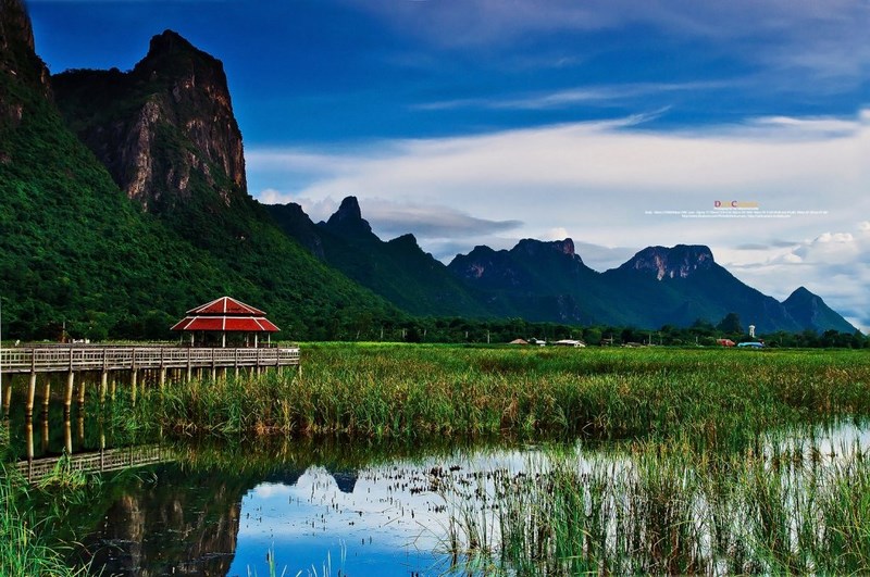
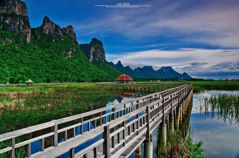
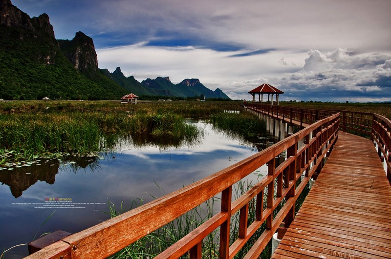
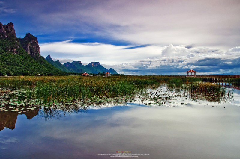
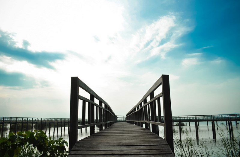
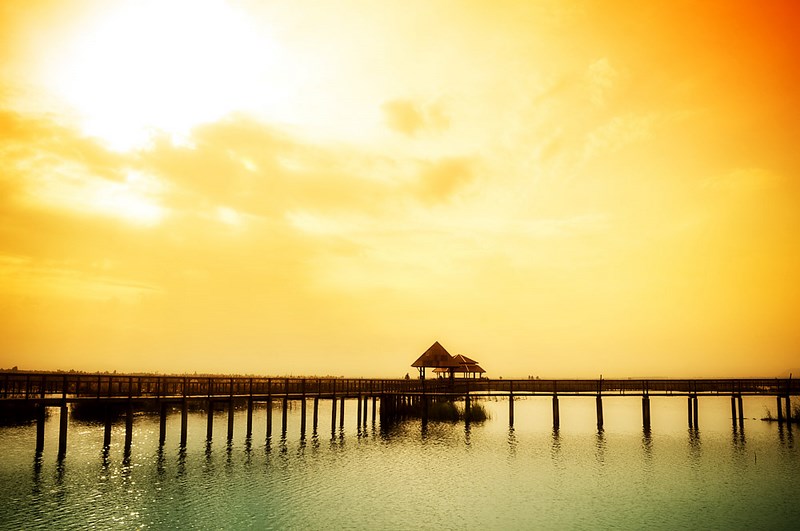
Khao Sam Roi Yot National Park, Prachuap Khiri Khan Province, is the first marine national park in Thailand. Its landscape is distinguished by towering limestone mountains lining the coast, vast lotus wetlands, limestone caves, and an internationally significant wetland ecosystem. Major attractions include Phraya Nakhon Cave, the Kuha Karuhas Pavilion, Bueng Bua Sam Roi Yot, Laem Sala Beach, and the Khao Daeng Viewpoint. It is an ideal destination for hiking, birdwatching, and nature-based travel.
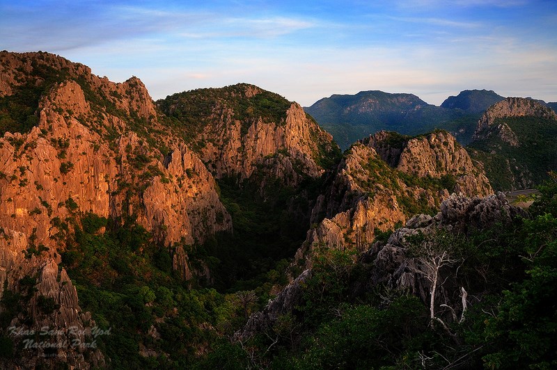
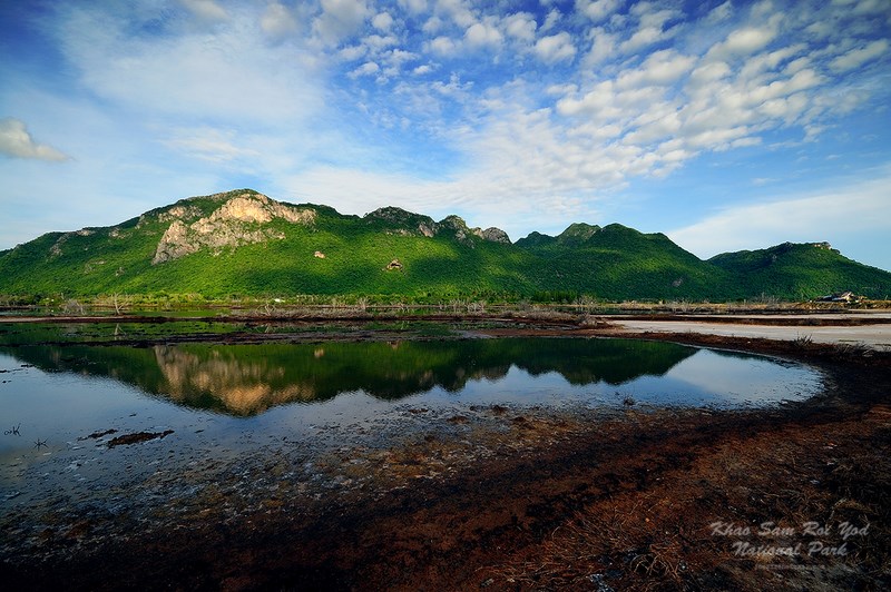
Khao Sam Roi Yot National Park is one of the most famous natural attractions in Prachuap Khiri Khan Province and is officially recognized as Thailand’s first marine national park. The area is notable for its long chain of limestone mountains stretching along the Gulf of Thailand, creating scenery that is both unusual and strikingly beautiful compared with mountain landscapes in other parts of the country. In addition to the limestone peaks, the park also includes grasslands, large wetlands, mangrove forests, and beaches that still retain a natural atmosphere. This makes the park an important destination for travelers who want to experience nature up close.
The park is located in Kui Buri District and Sam Roi Yot District of Prachuap Khiri Khan Province, about 63 kilometers south of Hua Hin. Its terrain consists of limestone mountains formed by geological uplift in the distant past, resulting in numerous peaks lined up in a long coastal formation. From afar, these mountain tops appear layered one behind another, creating a distinctive landscape that has become the visual identity of this area.
The name “Sam Roi Yot” comes from a long-standing local legend. According to the story, this area was once a vast sea filled with many small and large islands. At one time, a fleet of Chinese trading junks passed through the area but encountered a violent monsoon storm that caused the ships to sink. Three hundred survivors scattered across the islands and took shelter there, so the place became known as “Ko Sam Roi Rot,” or “the island of three hundred survivors.” Over time, the pronunciation gradually shifted in local speech until it became “Khao Sam Roi Yot,” the name still used today.
In terms of conservation history, Khao Sam Roi Yot National Park was declared a national park in 1966 and became Thailand’s first marine national park. The creation of the park aimed to protect important natural resources, including the limestone mountains, coastal landscapes, wetland ecosystems, and habitats of many species of wildlife, especially waterbirds that inhabit the marshes and wetland areas within the park.
The geography of Khao Sam Roi Yot National Park is highly diverse. Part of the area is made up of steep limestone mountains that have been shaped by natural erosion over millions of years, creating cliffs, caves, and rocky chambers. Meanwhile, the lower plains contain wetlands and expansive grasslands that serve as habitats for many species of wildlife. The park also includes mangrove forests, which help prevent coastal erosion and serve as important nursery grounds for marine life along the coast.
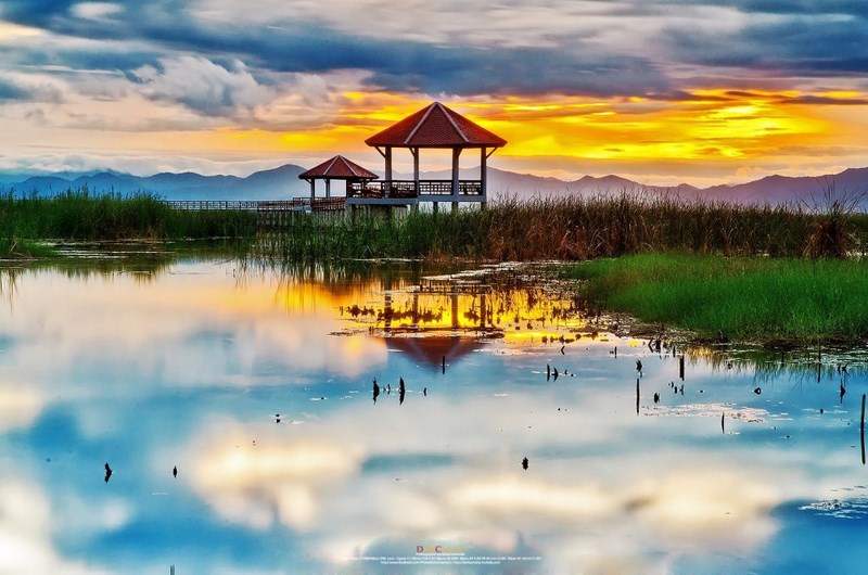
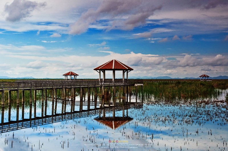
One of the park’s most important attractions is “Bueng Bua Sam Roi Yot,” a large wetland filled with lotus flowers. During the cool season, the lotus blooms spread across the marsh, creating a beautiful natural scene. Visitors can take a boat ride through the lotus marsh to enjoy the landscape and observe a variety of waterbirds that live in the area.
Another iconic attraction that has made Khao Sam Roi Yot National Park famous nationwide is “Phraya Nakhon Cave,” located near Laem Sala Beach. Inside the cave is a large opening in the roof that allows sunlight to shine directly onto the cave floor. Within this cave stands the “Kuha Karuhas Pavilion,” which was built during the reign of King Chulalongkorn (Rama V) to commemorate his royal visit to the cave. The pavilion, illuminated by sunlight streaming through the opening above, creates a breathtaking image and has become one of the most recognizable symbols of the park.
Along the coastline of the park there are also peaceful beaches such as Laem Sala Beach, which offers a shaded and relaxing atmosphere. Many visitors come here to begin the walking trail to Phraya Nakhon Cave, while others use the beach area as a place for camping and resting in a natural seaside setting.
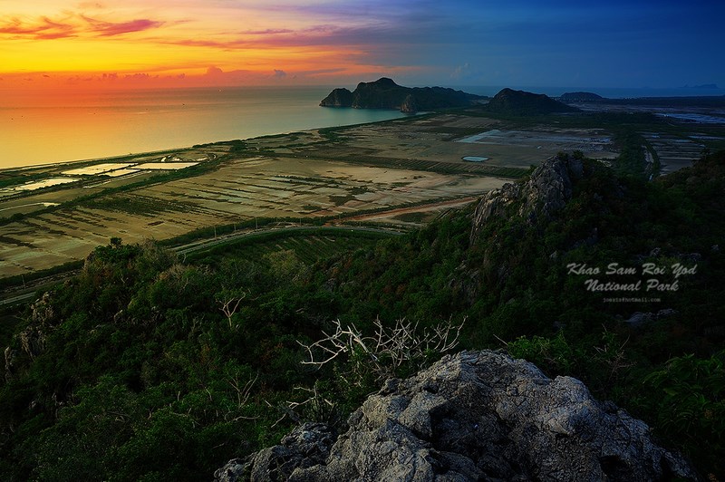
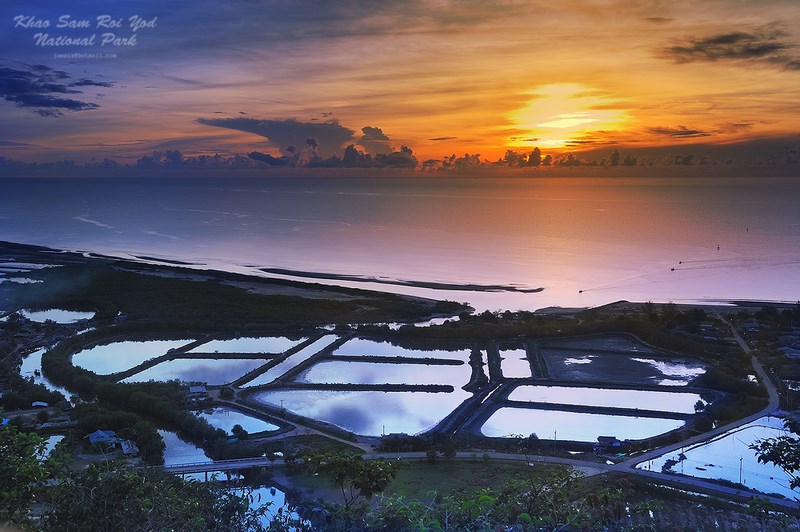
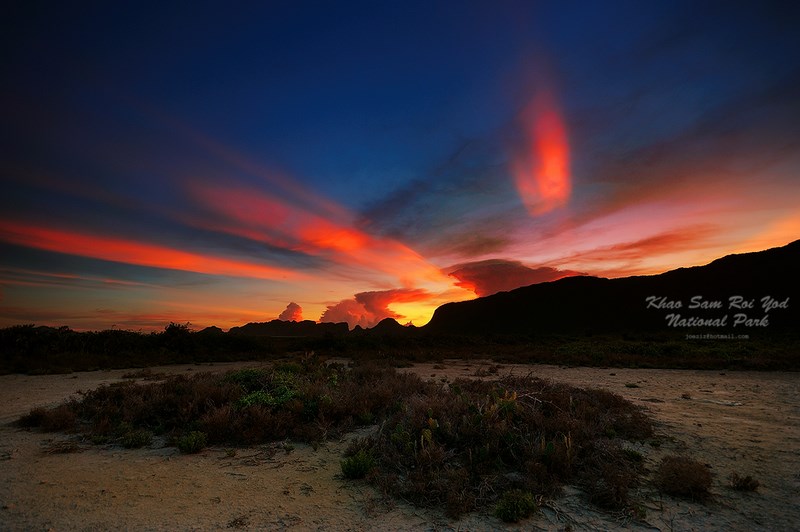
For those who enjoy scenic viewpoints, the Khao Daeng Viewpoint is another place not to miss. This viewpoint is located on a hill near the fishing village of Khao Daeng. From the top, visitors can enjoy sweeping views of the sea, limestone mountains, and the park’s wetland landscapes. It is especially beautiful at sunrise, when the sky and sea change colors, making it a favorite location for both travelers and nature photographers.
Beyond its scenic beauty, Khao Sam Roi Yot National Park is also important for its biodiversity, especially as a habitat for many species of waterbirds. The marshes and wetlands within the park provide food and shelter for migratory birds from various countries during the cool season. For this reason, the area has been recognized as a wetland of international importance under the Ramsar Convention.
There are several ways to travel to Khao Sam Roi Yot National Park. Visitors traveling by private car can use Phetkasem Road (Highway 4), then turn onto the Pran Buri – Pak Nam Pran Buri route and follow the road signs into the park. The distance from Hua Hin is about 63 kilometers. It is also possible to travel by bus, getting off at Pran Buri and continuing by local songthaew to Ban Bang Pu before hiring a local vehicle into the park. Another option is to travel by train from Thon Buri Station to Sam Roi Yot Station, then continue by local transport into the park area.
With its dramatic landscape, varied ecosystems, and famous natural attractions, Khao Sam Roi Yot National Park is an important destination both for nature conservation and ecotourism. Visitors to this park can experience limestone mountains, natural caves, expansive wetlands, and quiet beaches, all of which reflect the richness of nature along Thailand’s Gulf coast in a vivid and memorable way.
| Name | Khao Sam Roi Yot National Park |
| Location | Kui Buri District and Sam Roi Yot District, Prachuap Khiri Khan Province |
| Place Summary | Thailand’s first marine national park, featuring numerous limestone mountains, large wetlands, and an important birdwatching area |
| Highlights | Phraya Nakhon Cave, Kuha Karuhas Pavilion, Bueng Bua Sam Roi Yot, Laem Sala Beach, Khao Daeng Viewpoint |
| Getting There | About 63 kilometers from Hua Hin via Phetkasem Road and the Pran Buri route |
| Current Status | Open to visitors during national park operating hours |
| Contact Number | 032-821568 |
| Nearby Attractions with Distance | 1. Sam Phraya Beach – about 6 km – Tel. 032-821568 2. Khao Daeng – about 7 km 3. Sai Cave – about 12 km 4. Kui Buri National Park – about 55 km – Tel. 032-611275 5. Ao Manao – about 70 km – Tel. 032-661088 |
| Nearby Restaurants with Distance | 1. Jim-Daeng Restaurant – about 8 km – Tel. 081-701-0693 2. Krua Baan Pran – about 25 km – Tel. 032-631-026 3. Krua Lung Rang Seafood – about 20 km – Tel. 089-918-5530 4. Krua Sam Roi Yot Seafood – about 15 km – Tel. 032-559-164 5. Lung Chom Seafood – about 18 km – Tel. 081-815-6673 |
| Nearby Accommodations with Distance | 1. Dolphin Bay Resort – about 10 km – Tel. 032-559-200 2. Anchana Resort – about 12 km – Tel. 032-559-222 3. Green Beach Resort – about 9 km – Tel. 032-559-056 4. Namaste Resort – about 11 km – Tel. 032-559-310 5. Samroiyod Holiday Resort – about 14 km – Tel. 032-559-150 |
Frequently Asked Questions (FAQ)
Q: Which province is Khao Sam Roi Yot National Park in?
A: Khao Sam Roi Yot National Park is in Prachuap Khiri Khan Province and covers areas in Kui Buri District and Sam Roi Yot District.
Q: What are the main attractions of Khao Sam Roi Yot?
A: The park’s highlights include Phraya Nakhon Cave, the Kuha Karuhas Pavilion, Bueng Bua Sam Roi Yot, and the Khao Daeng Viewpoint.
Q: Is the walk to Phraya Nakhon Cave long?
A: The walk is about 430 meters from Laem Sala Beach, with a trail that includes a slight uphill section.
Q: What is the best time to visit Khao Sam Roi Yot?
A: The best period is from November to April, when the weather is suitable for hiking and enjoying nature.
Q: Can visitors camp inside the park?
A: Yes, camping is allowed in designated areas of the park, such as Laem Sala Beach.
Q: What is Bueng Bua Sam Roi Yot?
A: It is a large wetland filled with lotus flowers and is also one of the park’s key birdwatching areas.
 Category:
  Group:
 Comment
Photo Gellery(15) 
|
|
|
|
|
|
 | ● Photographer: Rafaantneverdie ● Link: facebook.com/PhotoByDarkcamera ● Ref: 500px.com/DarkCamera |
|
|
|
 | ● Photographer: Fukez84 ● Link: pixpros.net/forums/showthread.php ● Ref: pixpros.net |
|
|
|
|
|
|
 | ● Photographer: Joeziz photography ● Link: facebook.com/JoezizPhotography ● Ref: facebook.com |
● Copyright Photography. (800*500)
● View full size images from the photographer.
● View full size images from the photographer.
| Keyword (Advance) |
 Facebook Fanpage
 Art, Culture and Heritage
 Historical Sites and Monuments(
 Landmarks and Memorials(
 Royal Palace(
 Art, Craft Centres, Tradition(
 Art Gallery(
 Educational Places
 Museum for Study(
 Educational Gardens, Farm(
 University
 Places of Worship
 Temple(
 Other religious and spiritural sites(
 Research and Development
 Royal Project(
 Suburban Living
 Village, Community(
 Local Market(
 Floating Market(
") Mountain (Doi)(
Mountain (Doi)( Dam, Reservoir, Lake(
 Waterfalls(
 Caves(
 River, Canal(
 Bays and Beaches(
 Islands(
 Other natural attractions(
 Entertainment and Agricultural
 Animal camps and shows(
 Farm, Parks, Gardens and Ecotourism(
 Waterpark(
 Outdoor and Adventure Activities(
 Shopping
 Shopping and Night Market(
 Travel Articles, Recipes
 Travel Review, Food Review(