


Rating: 3.7/5 (7 votes)
Kanchanaburi attractions
Attractions in Thailand
Open Days: Open daily (public areas on the dam crest and surrounding zones)
Opening Hours: 06:00 – 18:00
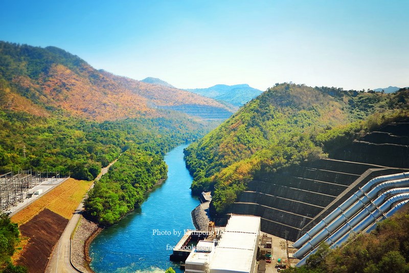
Srinakarin Dam, located in Kanchanaburi Province, lies on the upper reaches of the Khwae Yai River. It is one of Thailand’s most significant multipurpose dams in terms of engineering, energy production, water resource management, and tourism. The dam is the largest rockfill dam with a clay core in Thailand, constructed to block the Khwae Yai River and create a vast reservoir. It has long served as a central pillar of the national power system and water management framework in the Mae Klong River Basin.
Srinakarin Dam is situated in Si Sawat District, Kanchanaburi Province, approximately 4 kilometers from Erawan Waterfall and about 70 kilometers from Kanchanaburi town. Access is via Highway No. 3199 (Kanchanaburi–Si Sawat), an important route linking major natural attractions and large-scale development projects in the area. The surrounding landscape consists of rugged mountains, forests, and rivers, giving the dam both infrastructural importance and outstanding scenic value.
The construction of Srinakarin Dam took place during a period when Thailand was rapidly expanding its energy and water infrastructure to support economic growth and rising electricity demand. The dam is operated by the Electricity Generating Authority of Thailand (EGAT) and was designed as a multipurpose project capable of serving multiple functions, including hydroelectric power generation, irrigation, flood mitigation, and regional economic development.
From an engineering perspective, Srinakarin Dam is a rockfill dam with a clay core, a structure known for its high strength and suitability for mountainous terrain and geological conditions along the Khwae Yai River. The dam complex includes the main dam structure, a large reservoir, a hydroelectric power plant, spillways, and modern safety control systems. This type of dam can withstand immense water pressure and offers flexibility against natural vibrations and seismic activity.
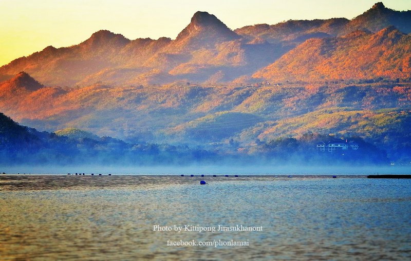
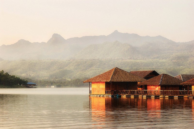
The Srinakarin Reservoir, created by damming the Khwae Yai River, extends over a vast area and stretches for dozens of kilometers. It functions as the principal water storage source for the upper basin. Water in the reservoir is systematically managed to ensure year-round availability for power generation, agricultural irrigation, and ecological balance in downstream river systems. The reservoir’s large storage capacity makes Srinakarin Dam a key component of water management in western Thailand.
Hydroelectric power generation is the primary function of Srinakarin Dam. The power plant uses the potential energy of stored water to generate electricity, which is then transmitted into Thailand’s national grid. This contributes significantly to national energy security, especially during periods of high electricity demand. Hydropower is also considered a clean energy source, helping reduce dependence on fossil fuels and minimizing long-term environmental impacts.
In addition to electricity production, Srinakarin Dam plays a crucial role in irrigation and water allocation. Water released from the reservoir flows into the Khwae Yai River and onward to the Mae Klong River Basin, supporting agricultural activities in Kanchanaburi, Ratchaburi, and other downstream provinces. Effective water management enables farmers to plan cultivation more efficiently, reduces drought risk, and enhances economic stability in the agricultural sector.
Another equally important role of Srinakarin Dam is flood mitigation in the Mae Klong River Basin. During the rainy season, when upstream runoff increases, the dam helps retain excess water and regulate its release in a controlled manner. This significantly reduces the severity of flooding in downstream areas. Past flood events demonstrate that large dams, when properly managed, can greatly reduce damage to lives and property.
From an ecological perspective, the Srinakarin Reservoir serves as a large freshwater habitat supporting a wide range of fish and other aquatic species. Local communities engage in small-scale fisheries and aquaculture alongside conservation efforts. Managing fisheries in such a large reservoir requires close cooperation between government agencies and local residents to ensure sustainable use of aquatic resources.
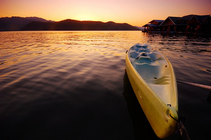
The crest of Srinakarin Dam offers sweeping panoramic views of the expansive reservoir and the surrounding mountain ranges. The atmosphere during early mornings and late afternoons is particularly appealing, with mist, soft sunlight, and tranquil natural surroundings. As a result, the dam crest has become a popular recreational spot for visitors and local residents alike.
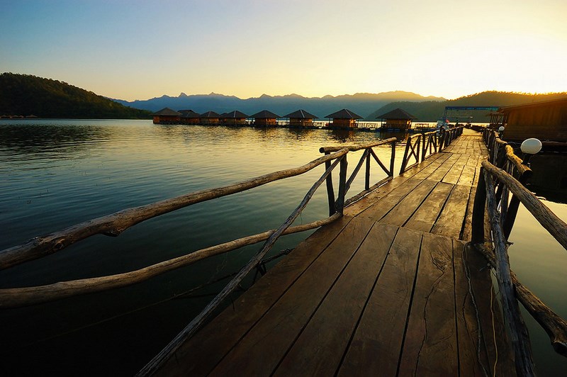
Tourism at Srinakarin Dam combines engineering-based learning with nature-oriented experiences. Visitors can gain insight into the dam’s role in energy production and water management while enjoying the surrounding natural scenery. Popular activities include walking along the dam crest, photography, relaxing by the reservoir, and visiting nearby attractions such as Erawan Waterfall and Srinakarin National Park.
Srinakarin Dam also provides official guesthouses for visitors, operated by the Electricity Generating Authority of Thailand. These accommodations are set in peaceful locations with scenic views, making them ideal for overnight stays and immersive experiences near the reservoir. In addition, there are on-site restaurants and boat services offering cruises on the reservoir, further enhancing the range of tourist activities.
Getting There Srinakarin Dam can be reached by private car from Kanchanaburi town via Highway No. 3199 (Kanchanaburi–Si Sawat), a distance of approximately 70 kilometers. The route winds through mountainous and forested areas, so drivers should exercise caution, especially during the rainy season.
| Overview | A large multipurpose dam on the Khwae Yai River for hydropower, irrigation, flood control, and tourism |
| Key Highlights | Thailand’s largest rockfill dam with clay core, scenic views, vast reservoir, EGAT guesthouses |
| Nearby Attractions | 1) Erawan Waterfall — approx. 4 km 2) Srinakarin National Park — approx. 10 km 3) Huai Mae Khamin Waterfall — approx. 25 km 4) Srinakarin Reservoir — same area 5) Scenic Route 3199 — approx. 5 km |
| Nearby Restaurants | 1) Srinakarin Dam Restaurant — approx. 1 km — Tel. 034-574-001 ext. 2455 2) Floating Restaurant Cruise — approx. 1 km — Tel. 034-574-001 ext. 2457 3) Si Sawat Local Restaurant — approx. 15 km — Tel. 034-575-111 4) Si Sawat Home-style Eatery — approx. 15 km — Tel. 034-575-222 5) Riverside Khwae Yai Restaurant — approx. 20 km — Tel. 034-575-333 |
| Nearby Accommodations | 1) Srinakarin Dam Guesthouse (EGAT) — on-site — Tel. 0-2436-6046-8 2) Si Sawat Resort — approx. 15 km — Tel. 034-576-111 3) Si Sawat Guesthouse — approx. 15 km — Tel. 034-576-222 4) Accommodation near Erawan Waterfall — approx. 5 km — Tel. 034-576-333 5) Khwae Yai Riverside Resort — approx. 20 km — Tel. 034-576-444 |
Frequently Asked Questions (FAQ)
Q: What is the main purpose of Srinakarin Dam?
A: It was built for hydropower generation, water management, irrigation, and flood control in the Mae Klong River Basin.
Q: How far is Srinakarin Dam from Erawan Waterfall?
A: It is approximately 4 kilometers away.
Q: Is the dam open to visitors every day?
A: Yes, public areas are open daily from 06:00 to 18:00.
Q: Where does the electricity from Srinakarin Dam go?
A: The electricity generated is supplied to Thailand’s national power grid, serving multiple regions.
Q: What activities can visitors enjoy at the dam?
A: Scenic viewing, walking along the dam crest, boat cruises, staying in guesthouses, and visiting nearby natural attractions.
 Category:
  Group:
 Comment
Photo Gellery(6) 
|
|
|
 | ● Photographer: Kittipong Jirasukhanont ● Link: facebook.com/phonlamaiphoto ● Ref: thaidphoto.com |
|
|
|
 | ● Photographer: Tj Armer ● Link: tjarmer.multiply.com ● Ref: pixpros.net |
● Copyright Photography. (800*500)
● View full size images from the photographer.
● View full size images from the photographer.
| Keyword (Advance) |
 Facebook Fanpage
 Art, Culture and Heritage
 Historical Sites and Monuments(
 Landmarks and Memorials(
 Art, Craft Centres, Tradition(
 Museums(
 Art Gallery(
 University
 Places of Worship
 Temple(
 Church(
 Other religious and spiritural sites(
 Research and Development
 Royal Project(
 Suburban Living
 Village, Community(
 Local Market(
 National Parks and Marine Reserves(
") Mountain (Doi)(
Mountain (Doi)( Waterfalls(
 Hot Springs(
 Caves(
 River, Canal(
 Other natural attractions(
 Entertainment and Agricultural
 Zoos and Aquariums(
 Animal camps and shows(
 Farm, Parks, Gardens and Ecotourism(
 Cinema(
 Outdoor and Adventure Activities(
 Travel Articles, Recipes
 Travel Review, Food Review(