
lovethailand home >South Travel Attractions >Yala Travel Attractions >Raman >Ka Yu Bo Koh > Bue Yong Waterfall
TL;DR: Bue Yong Waterfall is located at Moo 3, Ban Bue Yong, Kayu Boko Subdistrict, Raman District, Yala Province, open Daily, hours 08.00 – 17.00.

Bue Yong Waterfall
Open Days: Daily
Opening Hours: 08.00 – 17.00
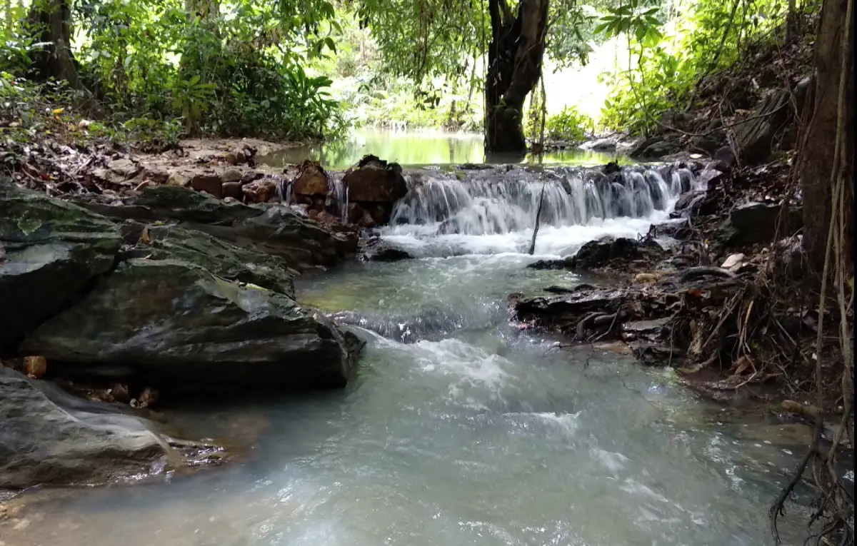
Bue Yong Waterfall in Yala Province is a four-tier community waterfall about 10 meters high, located in Moo 3, Ban Bue Yong, Kayu Boko Subdistrict, Raman District. It lies along the Yala – Raman route, about 22 km from Yala city. Before reaching Ban Bue Yong School, turn right onto the local Subdistrict Administrative Organization road and continue for about 1.5 km to the waterfall. The lower area has a large natural pond suitable for relaxation and careful water play. The atmosphere is shaded, humid, and community-oriented, with access steps for viewing all four tiers. The waterfall is also an important mountain-water supply source for Ban Bue Yong residents.
Bue Yong Waterfall is a natural community waterfall in Raman District, Yala Province. It is located in Moo 3, Ban Bue Yong, Kayu Boko Subdistrict, and is valued not only as a place for recreation but also as a local water source. Compared with larger forest waterfalls in southern Yala, Bue Yong Waterfall is smaller and more closely connected with village life. Its appeal comes from clear water, shaded surroundings, a large lower pond, fruit orchards along the access route, and the role it plays in the daily life of Ban Bue Yong.
The waterfall has four tiers and an approximate height of 10 meters. Water flows down through natural rock levels and stream sections before gathering in a large pond below. This lower pond is one of the main reasons local residents visit the area for rest and water play during free time. The waterfall feels cool and moist because it sits within a green local landscape shaped by streams, orchards, rubber plantations, and low hill areas.
Bue Yong Waterfall should not be understood only as a small swimming spot. It is also an important mountain-water supply source for people in Ban Bue Yong. This gives the site practical community value. The waterfall connects forest cover, local streams, agriculture, household water use, and recreation in one place. Keeping the area clean therefore protects both tourism value and local water quality.
The local Subdistrict Administrative Organization has prepared access steps for residents and visitors to walk and view the height and beauty of the four waterfall tiers. These basic improvements make the waterfall easier to enjoy while keeping its community-natural character. Visitors should still move carefully because natural waterfall areas may include wet rocks, slopes, uneven surfaces, and slippery sections, especially after rain.
Every year, local youth, parents, and community members take part in improving the landscape, planting trees, and caring for the waterfall area. This community involvement is an important part of the identity of Bue Yong Waterfall. It shows that the site is not simply a tourist attraction but a shared public space maintained by people who live near it and depend on the surrounding environment.
Kayu Boko Subdistrict is largely agricultural. The area includes flatland, lowland, some upland and low hill sections, rubber plantations, fruit orchards, rice fields, streams, canals, and ponds. This physical setting explains why Bue Yong Waterfall has a strong local character. The route to the waterfall passes through village and orchard landscapes rather than a highly commercial tourist zone.
Getting to the waterfall is straightforward. From Yala city, take the Yala – Raman road for about 22 km. Before reaching Ban Bue Yong School, turn right onto the local administrative road and continue for about 1.5 km to the waterfall area. Private car, rental car, motorcycle, or local hired transport is recommended because it allows flexible timing and makes it easier to combine the waterfall with other places in Raman and Yala.
Bue Yong Waterfall works well as a half-day trip from Yala city. Travelers can leave in the morning, reach Raman District, spend time resting by the pond, enjoy safe water play, walk along the viewing route, and take photographs. Afterward, they can continue to Raman town, Kota Baru Old Town, Bukeh Pilo Waterfall, Wat Khuhaphimuk, Tham Sin Cave, or return to Yala city for food and accommodation.
The large pond below the waterfall makes the area especially suitable for family-style relaxation. However, water play must be limited to safe sections. Visitors should choose shallow, calm areas where the bottom can be seen clearly. Children must be supervised closely at all times. Even though the waterfall is not very high, natural streams can become risky after rain because rocks are slippery and water levels can change quickly.
The best time to visit is from morning to early afternoon. This period offers enough light for walking, photography, and safe return from the local access road. During the rainy season, the waterfall and stream may look fresher, but slippery surfaces and stronger flow require more caution. During drier periods, access is usually easier, although the amount of water may vary naturally.
Recommended activities include resting by the lower pond, playing in safe water areas, walking to view the four waterfall tiers, photographing streams and fruit orchards, learning about mountain-water supply, and enjoying a quiet community nature setting. The waterfall is not defined by dramatic height but by the balanced relationship between natural water, village life, and local landscape care.
For photography, useful subjects include the four-tier stream, lower pond, rock surfaces, access steps, trees planted by the community, and fruit orchards along the road. The best photographs show the waterfall together with its local surroundings. Visitors should avoid standing on wet rocks or entering unsafe water just to take a better photo.
Main cautions include slippery rocks, water-level changes after rain, and responsible use of a community water source. Visitors should wear non-slip footwear, avoid climbing wet stones, avoid jumping into unknown pools, and leave the stream immediately if the water becomes muddy or flow increases. Waste must be carried out because pollution can affect both the recreation area and the water supply.
Because Bue Yong Waterfall is close to a living community, visitors should drive slowly, avoid blocking village roads, keep noise low, respect local residents, and avoid damaging plants or stream areas. Tourism should support the community atmosphere rather than create disturbance. The waterfall remains attractive because it is cared for by local people and used responsibly.
Kayu Boko Subdistrict has a semi-rural community character. Agriculture is a major livelihood, especially rubber, fruit orchards, and rice farming. When viewed within this context, Bue Yong Waterfall becomes part of a wider local landscape rather than a standalone attraction. A visit helps travelers understand Raman as a district of villages, orchards, water sources, and cultural routes.
Kota Baru Old Town is a strong nearby cultural addition. It is linked with the history of old Raman, earthen wall remains, the former ruler’s residence area, and the Tomb of To Ni. Combining Bue Yong Waterfall with Kota Baru gives travelers both natural scenery and local historical depth in one route.
Bukeh Pilo Waterfall, also known as Tawan Ratsami Waterfall, is another natural attraction in Raman District. It is known for the golden-yellow appearance of underwater rocks when sunlight strikes the stream. Travelers who enjoy small waterfalls with distinctive identities can combine Bue Yong and Bukeh Pilo in the same day.
Wat Khuhaphimuk, also known as Wat Na Tham, and Tham Sin Cave are suitable additions for travelers starting from Yala city. Wat Khuhaphimuk is an important cave temple in Yala, while Tham Sin Cave is known for ancient wall paintings. A route combining Bue Yong Waterfall with these sites gives visitors nature, local community, cave heritage, and history in a single itinerary.
Food planning should focus on Raman town and Kayu Boko Subdistrict rather than the waterfall itself. Nearby dining options include halal restaurants, made-to-order meals, tea shops, cafés, and simple local eateries. Travelers who want more variety can return to Yala city, where there are more restaurants and hotels.
Most visitors should stay in Yala city because the waterfall is only about 22 km away and can be visited as a morning or afternoon trip. Yala city offers more hotels, restaurants, fuel stations, convenience stores, and transportation services. It also makes it easier to combine the waterfall with Kota Baru, Bukeh Pilo, Wat Khuhaphimuk, Tham Sin Cave, and Yala city attractions.
Useful items include non-slip footwear, a change of clothes, towel, waterproof phone pouch, drinking water, personal medicine, a trash bag, and some cash for local purchases. During rainy weather, light rain protection is useful. Visitors should check weather conditions before traveling because local roads and streamside surfaces may become slippery after rain.
Bue Yong Waterfall is a good example of a small destination with meaningful local value. It combines four waterfall tiers, a lower pond, community access steps, annual local landscape improvement, fruit orchards, and an important mountain-water supply role. Its strength is not size but authenticity and the close relationship between nature and the people of Ban Bue Yong.
Getting There from Yala city: take the Yala – Raman road for about 22 km. Before reaching Ban Bue Yong School, turn right onto the local Subdistrict Administrative Organization road and continue about 1.5 km to Bue Yong Waterfall. The route passes fruit orchards and village landscapes. A private car, rental car, motorcycle, or local hired vehicle is recommended. Travel during daylight for safer driving and water activities.
Overall, Bue Yong Waterfall is a modest but valuable nature attraction in Raman District. It offers a four-tier waterfall, a large lower pond, shaded surroundings, orchard scenery, local community care, and the environmental role of a mountain-water supply source. For travelers seeking a quiet and authentic nature stop near Yala city, Bue Yong Waterfall is a worthwhile place to include in a Raman travel route.
| Name | Bue Yong Waterfall |
| Thai Name | น้ำตกบือยอง |
| Location | Moo 3, Ban Bue Yong, Kayu Boko Subdistrict, Raman District, Yala Province |
| Address | Ban Bue Yong area, Moo 3, Kayu Boko Subdistrict, Raman District, Yala 95140, Thailand |
| Reference Coordinates For Ban Bue Yong Area | Latitude 6.47280020894, Longitude 101.400290608 |
| Highlights | Four-tier waterfall about 10 m high, large lower pond, shaded and humid atmosphere, and an important mountain-water supply source for Ban Bue Yong |
| Distinctive Features | Community waterfall with access steps for viewing four tiers, a stream, natural pond, rock areas, and fruit orchards along the local access road |
| Importance | A local recreation area and an important mountain-water supply source for the people of Ban Bue Yong |
| Area Context | Kayu Boko Subdistrict includes agricultural land, rubber plantations, fruit orchards, rice fields, upland areas, low hills, natural canals, streams, and ponds |
| Travel Information | From the Yala – Raman road, about 22 km from Yala city, turn right before Ban Bue Yong School and continue along the local administrative road for about 1.5 km to the waterfall |
| Current Status | Open as a community nature attraction and rest area, with local access improvements and ongoing landscape care by residents |
| Open Days | Daily |
| Opening Hours | 08.00 – 17.00 |
| Best Time To Visit | Morning to early afternoon, especially on days without heavy rain |
| Facilities | Access steps for viewing four waterfall tiers, lower pond, natural rest area, access road from the local SAO road, and basic services in nearby communities |
| Main Areas / Zones | Waterfall tiers 1 – 4, lower pond, stream, rocks, access steps, tree-planting area, and fruit-orchard access route |
| Caretaker / Coordinating Agency | Kayu Boko Subdistrict Administrative Organization, Raman District, Yala Province, and Ban Bue Yong community |
| Main Contact Number | Kayu Boko Subdistrict Administrative Organization Tel. 0-7329-9477 |
| Website / Information Sources | LoveThailand.org, Kayu Boko Subdistrict Administrative Organization, Yala Primary Educational Service Area Office 1, Ban Raman School, Princess Maha Chakri Sirindhorn Anthropology Centre, Ministry of Culture database, and public travel databases |
| Nearby Tourist Attractions | 1. Ban Bue Yong School and Ban Bue Yong community, about 1.5 km 2. Raman town and Kayu Boko area, about 5 km 3. Kota Baru Old Town, about 10 km 4. Tomb of To Ni and former Kota Baru ruler’s residence area, about 10 km 5. Bukeh Pilo or Tawan Ratsami Waterfall, about 20 km 6. Wat Khuhaphimuk or Wat Na Tham, about 28 km 7. Tham Sin Cave, about 30 km |
| Nearby Restaurants | 1. Krua Makan Islamic Food Raman, about 5 km, Tel. 084-720-0323 2. Fadel Food Raman, about 5 km, Tel. 096-212-1911 3. OWL CHA Yala Raman Branch, about 5 km, Tel. 098-729-4638 4. Sami Junee Kitchen Raman, about 6 km, Tel. 080-220-3907 5. Ban Kabu, about 6 km, Tel. 093-715-6714 6. Raman Coconut by Thep Raman Coffee, about 25 km, Tel. 090-220-0279 |
| Nearby Accommodations | 1. @INN YRU Hotel, about 25 km, Tel. 062-182-2662 2. Park View Hotel Yala, about 25 km, Tel. 073-217001-5 3. Yala Rama Hotel, about 25 km, Tel. 073-212563, 073-212815, 073-212841 4. The Linux Garden Hotel Yala, about 26 km, Tel. 073-299-578 5. Yala My House Hotel, about 25 km, Tel. 073-221-236 6. Boonrapee Residence Yala, about 26 km, Tel. 099-489-9449 |
Frequently Asked Questions (FAQ)
Q: Where is Bue Yong Waterfall located?
A: Bue Yong Waterfall is located in Moo 3, Ban Bue Yong, Kayu Boko Subdistrict, Raman District, Yala Province, along the Yala – Raman route.
Q: What are the opening hours?
A: Bue Yong Waterfall is open daily from 08.00 to 17.00. Morning to early afternoon is the best time for visiting and water activities.
Q: How many tiers does Bue Yong Waterfall have?
A: Bue Yong Waterfall has four tiers and is about 10 meters high, with access steps for viewing the tiers and a large pond at the lower section.
Q: Can visitors swim at Bue Yong Waterfall?
A: Water play is possible in safe areas, especially shallow and calm sections. Visitors should be careful with slippery rocks, changing water levels after rain, and children should be supervised closely.
Q: Why is Bue Yong Waterfall important to the local community?
A: It is both a recreation area for local residents and an important mountain-water supply source for the people of Ban Bue Yong.
Q: How do travelers get to Bue Yong Waterfall?
A: From Yala city, take the Yala – Raman road for about 22 km. Before reaching Ban Bue Yong School, turn right onto the local SAO road and continue about 1.5 km to the waterfall.
Q: What should visitors prepare before going?
A: Bring non-slip footwear, a change of clothes, towel, waterproof phone pouch, drinking water, personal medicine, a trash bag, and check weather conditions before departure.
Q: What nearby attractions can be combined with the waterfall?
A: Good nearby options include Raman town, Kota Baru Old Town, Tomb of To Ni, Bukeh Pilo Waterfall, Wat Khuhaphimuk, Tham Sin Cave, and Yala city.
 Category: ●Nature and Wildlife
 Group: ●Waterfalls
Last Update : 2 WeekAgo
 Last Update : 2 WeekAgo
 Click to Access the Navigation Map GPS
Bue Yong Waterfall Map

 Art, Culture and Heritage
 Landmarks and Memorials(1)
 Art, Craft Centres, Tradition(2)
 Museums(2)
 Educational Places
 Educational Gardens, Farm(1)
 Places of Worship
 Temple(6)
 Mosque(2)
 Other Sacred Sites(3)
 Suburban Living
 Village, Community(4)
 National Parks and Marine Reserves(2)
 Mountain (Doi)(5)
 Dam, Reservoir, Lake(5)
Waterfalls(13)
Dam, Reservoir, Lake(5)
Waterfalls(13)
 Hot Springs(2)
 Caves(7)
 River, Canal(4)
 Islands(1)
 Other natural attractions(8)
 Entertainment and Agricultural
 Stadium(1)
 Farms, Parks and Ecotourism(4)
 Outdoor and Adventure Activities(1)
 Travel Articles, Recipes
 Travel Review, Food Review(2)


